BlockBefore
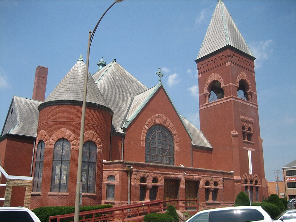
Photograph of First Congregational Church of Sterling
Photograph by IvoShandor, CC BY 2.5. Via Wikimedia Commons.

First Congregational Church of Sterling

Listed on the National Register of Historic Places in 1995.

From the record

“The First Congregational Church of Sterling is a historic church in Sterling, Illinois, United States. The church was built in 1897 and 1898 and is an example of Richardsonian Romanesque architecture.”

Wikipedia article First Congregational Church of Sterling, CC BY-SA 4.0.

One of 11 National Register listings published here for Whiteside County · listed in 1995 · category: Building.

Sources: the Wikipedia article · the case file at the National Archives · the National Register database, National Park Service

The listing

  • What is counted as historic. The nomination lists 1 building as contributing to the listing.
  • Address. 311 Second Ave., Sterling, 61081
  • When was it listed? November 1995
  • Category. building
  • Township. Sterling township
  • Architectural style. Richardsonian Romanesque
  • National Register reference number. 95001234 - the number the National Park Service assigned this property when it was listed, and the key its nomination file is catalogued under at the National Archives.

What happened here

An account from the chapter on Sterling township. The inset identifies its exact source book and publication year.

From History of Whiteside County, Illinois from Its Earliest Settlement to 1908 : Illustrated, with Biographical Sketches of Some Prominent Citizens of the County, published 1908 - Sterling Township

From The Firing Line

Few of our veterans passed through such a continued and exhausting siege of suffering as Isaac Bressler, who enlisted in the 88th Illinois at Chicago, Col. Sherman, 1862, fought at Murfreesboro and Chickamauga, where he was captured with 3,000 men, and taken to Richmond. This was the beginning of a series of imprisonments and rebel torture.

Read the rest of this passage

The ground it stands on

70,698 words

The chapter on Sterling Township in History of Whiteside County, Illinois, from Its First Settlement to the Present Time;, published 1877 names Sterling. This is what it says, exactly as the scans read.

Sterling are three large flouring mills, and nearly a dozen manufactories which derive the motive power for their machinery from this source, and these take only a portion of the power, the Rock Falls mills and manufactories dividing it with them. Most of these manufactories have been built within the past few years, and the number is still steadily on the increase. How many there will be in a score of years from now, human ken cannot foretell. The stately and capacious structures which have already been erected, and the almost ceaseless whirl and hum of their machinery, indicate a constant and growing business in the manufacture of the diiferent kinds of implements and goods carried on within their walls. This must beget competition, as well as induce manufacturers of other staples, and not unlikely luxuries, to seek this favored locality, and erect other and even more pretentious buildings, containing the most powerful and improved machinery, side by side with those which now send forth to all of the States and Territories, and even to many of the foreign lands, articles which equal any of their kind in excellence of make, and beauty of finish. It is not in the nature of things for a power like that at Sterling to keep in motion only the running gear of a limited number of works. It will keep grasping continually for additional wheels, and pulleys, and spindles, and engines, until it is enabled to use all its vast propelling force. 'Sterling, therefore, possessing this power, cannot fail of becoming one of the largest and most important inland manufacturing points in the great West. The next decade may see the smoke arising from the tall chimnies of an hundred factories, and the citizens of the city daily hear the clang and clamor, the hum and the whirl, that issue from, and witness if they choose the hurry and the bustle that abound in, these hundred temples of manufacturing thrift and enterprise. The rich and prolific agricultural country which surrounds Sterling can easily furnish subsistence for the hundreds, or thousands, of mechanics and operatives whose services these factories will require, and the railroad facilities will always be made sufiicient to meet the demand for the import of the raw material, not furnished by home supply, and the export of the manufactured article.

Passage source: History of Whiteside County, Illinois, from Its First Settlement to the Present Time;, published 1877.

The present city of Sterling took its rise from the combination of two towns or villages, known as Harrisburgh and Chatham. Harrisburgh was settled first, the pioneer being Hezekiah Brink, who in early June, 1834, put up a house of logs and rifted lumber in what is now the First Ward of Sterling. This primitive building was the first one erected in the now populous city. Mr. Brink's nearest neighbor at that time was Mr. McClure, who had made a claim on Rock river, near the present village of Prophetstown. Close to his habitation rolled the beautiful Rock river, the Siunissippi of the Indians, and all around him was the boundless prairie, the only variation in the landscape being here and there along the river bank a narrow belt of timber. The place was desolate enough, and illy portended the growth in a comparatively few years of a large and wealthy city. Mr. Brink was soon afterwards joined by others, as mentioned in the history of the township, and the settlement began its career. In the summer of 1836, Capt. D. S. Harris, of the steamer Pioneer, came up the river with a load of provisions, and landed above the rapids, the settlers assisting with their ox teams in towing the boat over them to the landing point. A quantity of these provisions were sold to the settlers, and for payment the Captain took a one half interest in the town, which was then, in his honor, named Harrisburgh. Immediately afterwards Capt. Harris, Elijah Worthington, Hezekiah Brink, and others, had the town surveyed, laid out, and platted, the survey being made by Israel Mitchell, of Jo Daviess county, and the plat recorded in Ogle county. The town was bounded on the east and north by the city limits; on the west by what is now Vine street, in the city of Sterling, and on the south by Rock river. A meeting was held by Capt. Harris and the leading settlers on board the steamer while it was being taken over the rapids, and among other matters discussed was that of establishing a Postoffice in the new town, and it was finally decided that a petition asking for one should be forwarded to Washington, as soon as some other preliminary matters had been settled. This petition was sent on in due time to the Postoffice Pepartment, with a request that the name of the Postoffice be Rock River Rapids, and the Postmaster Hezekiah Brink. The Department immediately acted upon it, and granted both requests, but Mr. Brink declined to accept the position, and the Postoffice was abandoned. Some error having been discovered in the first survey, the town of Hai-risburgh was re-surveyed and re-platted in 1837, by Joseph Crawford, now President of the First National Bank at Dixon. Mr. Swan, an agent of Capt. Harris, built a store that season on the bank of the river, known afterwards as the Richardson House, which was occupied by Worthington & Brink, with a stock of goods. Several dwelling houses were also erected in 1836 and 1837.

Passage source: History of Whiteside County, Illinois, from Its First Settlement to the Present Time;, published 1877.

Machine-read from a century-old scan, so expect the errors a machine makes: misspelled names, dropped words, stray characters.

Read the whole chapter on Sterling Township - 70,698 words on its settlement, mills, schools and churches.

Fires near this property

4 since 2018

Regional context, not property-specific evidence. The federal wildfire occurrence database lists 4 fires within 5 miles of First Congregational Church of Sterling between 2018 and 2019, burning about 3 acres in total. None started naturally. None was recorded as arson. Distance is straight-line from the map coordinates, so a fire counted here may appear on a neighbouring settlement's page as well.

Reported cause Fires
Missing data/not specified/undetermined3
Debris and open burning1

The most recent of them, most recent first, with the day each was reported and the service that recorded it.

DateCause SizeReported by Name on the report
2 May 2018Missing data/not specified/undeterminedunder an acreIllinois Division of Forestry Resources18-369
18 May 2018Missing data/not specified/undeterminedunder an acreIllinois Division of Forestry Resources18-414
9 April 2019Missing data/not specified/undeterminedunder an acreIllinois Division of Forestry Resources19-322
23 March 2019Debris and open burning1.0 acresIllinois Division of Forestry Resources19-274

Every fire recorded in Whiteside County

Mines and quarries near this property

9 within 5 miles

Regional context, not property-specific evidence. The federal mineral resources record lists 9 workings within 5 miles of First Congregational Church of Sterling: 6 past producers, 2 plants, 1 producer. 3 still produce. What was taken out: Sand and Gravel, Construction, Stone, Crushed/Broken. Distance is straight-line from the map coordinates, so a quarry counted here may appear on a neighbouring settlement's page as well.

Where SiteCommodity StatusRecorded
Emerson Quarry & MillStone, Crushed/BrokenPlant
L. Deets QuarryStone, Crushed/BrokenPast Producer
Como PitSand and Gravel, ConstructionPast Producer
Mccue PitSand and Gravel, ConstructionPast Producer
Nelson Sand & Gravel Pit #2 &Sand and Gravel, ConstructionProducer
Propheter PitSand and Gravel, ConstructionPast Producer
Propheter Pit & MillSand and Gravel, ConstructionPast Producer
Rock Falls Pit and MillSand and Gravel, ConstructionPlant
Whiteside Blacktop Company PitSand and Gravel, ConstructionPast Producer

Every working recorded in Whiteside County

Storms near this property

60 of 65 shown

Regional context, not property-specific evidence. The National Weather Service names Sterling, the town this property stands in, in 65 storm reports between 1995 and 2024: 31 thunderstorm wind, 22 hail, 3 heavy rain, 3 flash flood. The reports record 1 injury. Each account below is quoted exactly as the forecast office filed it, from the NOAA Storm Events Database, and each date opens the federal record of that event.

WhenEvent Place namedHarm What the report says
February 1999Thunderstorm WindSterling1 hurt, $28,000no account filed
June 2009Thunderstorm WindSterling$25,000Wind gusts estimated to be 70 mph blew down a large tree at Avenue J and 6th St in Sterling, IL around 615 pm June 27. The tree snapped some power lines and blocked the road. Several other smaller branches were also blown down.
July 2003LightningSterling$20,000Large branch fell on house
July 2003HailSterling$20,000Tampico Rd.
June 2008Thunderstorm WindSterling$15,000Winds estimated to be 65 mph blew down several tree limbs on the west side of Sterling, IL around 11:05 am June 8. The limbs were over six inches in diameter. Some branches broke power lines and cable television lines. A power outage was also noted.
June 2010Thunderstorm WindSterling$10,000Wind gusts estimated to be 70 mph blew down 10 large trees at Emerald Hill Golf Course about 4 miles east northeast of Sterling, IL around 118 pm CST June 18. This report was relayed by a Rockford area television station.
August 2006Thunderstorm WindSterling$4,000A storm survey discovered numerous 3 to 5 inch diameter limbs down on the northwest side of the city.
August 2006Thunderstorm WindSterling$4,000A storm survey discovered numerous 2 to 12 inch diameter limbs down along highway 40 to the Sterling city limits.
May 1998Thunderstorm WindSterling$1,000Thunderstorm winds downed trees and limbs in Northeast Whiteside county.
May 2024Thunderstorm WindSterling-A tree limb was blown down. Time estimated from radar data.
July 2022Thunderstorm WindSterling-A public report of several large tree branches down. The time of the event was estimated using radar.
May 2020Thunderstorm WindSterling-Several reports of tree damage and power pole damage received from the Sterling Rock Falls area. There are numerous power outages on the north side of the city of Sterling.
July 2020Tornado (EFU)Sterling-A video posted on social media confirmed a landspout tornado in a field behind a Menards store on the northeast side of Sterling, Illinois. The tornado was brief and occurred in an open field. No damage was observed to assign an EF-Scale rating.
February 2018FloodSterling-Emergency management relayed widespread flooding of farms and roads near the Rock River, associated with major river flooding, as well as ice jam activity. At the Joslin, Illinois Rock River gauge exceeded major flood stage of 16.5 feet, at 240 PM, February 22nd, and fell back below major flood stage at 2 AM, February 26th. The Rock River at Joslin crested at 18.31 feet, at 115 PM, February 23rd.
February 2017HailSterling-A spotter reported dime size hail.
February 2017HailSterling-A spotter reported hail slightly larger than golf balls.
August 2016Flash FloodSterling-The public reported that there was significant water flowing across roads. Yards and parking lots were also flooded.
July 2016Thunderstorm WindSterling-Strong winds blew a tree onto power lines and damaged the power pole.
June 2015Tornado (EF1)Sterling-Hardwood trees and trunks were snapped, with peak wind speed of 100 mph on this short tornado spin up.
June 2015HailSterling-Hail was reported near Applebees restaurant, on Route 2.
June 2015Flash FloodSterling-Severe street flooding was reported in Sterling and Rock Falls. Water was at least 3 feet deep in streets. Several cars were stalled and pushed to higher ground. Sewer systems were inundated and water supply shut down.
November 2015Thunderstorm WindSterling-The Sterling Police Department reported a few power lines down along with a few tree branches around 4 inches in diameter. The time is based on radar.
August 2014Thunderstorm WindSterling-Wind gusts estimated to be 60 mph blew down a tree limb in Sterling, IL around 230 pm CDT August 25.
May 2013Thunderstorm WindSterling-A trained spotter reported trees and power lines blown down.
May 2013Thunderstorm WindSterling-A trained spotter measured 60 mph winds.
May 2013Thunderstorm WindSterling-A large tree was down on power lines near town.
June 2013Thunderstorm WindSterling-A trained spotter reported a wind gust of 70 mph.
August 2012Thunderstorm WindSterling-A few large diameter tree limbs down.
July 2012Thunderstorm WindSterling-The public reported several large diameter tree limbs down on the northwest side of Sterling. There were also reports of power outages.
July 2011Thunderstorm WindSterling-Wind gusts estimated to be 70 mph were observed in Sterling, IL at 653 am CDT July 11. Reports of trees and large limbs down on power lines in Sterling near the Sinnissippi Park. A number of residents in Whiteside County were left without power in the wake of the storm.
August 2011HailSterling-Hail fell for 1 to 2 minutes with hailstones varying in size from pea to quarter sized.
June 2010Thunderstorm WindSterling-Wind gusts estimated to be 60 mph blew down some large tree limbs in Sterling, IL at 239 pm June 18.
July 2009Flash FloodSterling-Heavy rains resulted in flash flooding of a portion of Highway 40 in Sterling, IL during the late evening hours of July 24. The roadway had to be closed for a time due to water over the road.
May 2008HailSterling-A trained spotter measured penny size hail near Sterling.
May 2008HailSterling-A trained spotter measured nickel size hail in Sterling.
May 2008HailSterling-A trained spotter estimated dime to quarter size hail fell for 6 minutes in Sterling.
June 2008Thunderstorm WindSterling-A 60 mph wind gust was measured in Sterling, IL at 11:35 pm June 12.
August 2008Thunderstorm WindSterling-Wind gusts estimated to be 65 mph blew down some large tree limbs eight inches in diameter across some roads 2 to 5 miles northeast of Sterling, IL at 633 pm August 4.
June 2007Thunderstorm WindSterling-Many trees and power lines were blown down by wind estimated at 70 mph.
June 2007Thunderstorm WindSterling-Many trees and power lines were blown down throughout Sterling by wind estimated at 70 mph.
April 2006Heavy RainSterling-1.05 inches of rain
April 2006HailSterling-pea to penny size hail
May 2006Thunderstorm WindSterling-Straight line winds & torrential rain; unsubstantiated reports of lightning damage to a department store and a high tension line down east of the city.
May 2006Thunderstorm WindSterling-Measured gust on wind equipment; also pea size hail
October 2006HailSterling-Hail from penny to nickel size for about 10 minutes.
October 2006HailSterling-Penny size hail covered the ground.
August 2005Heavy RainSterling-Water ponding on some streets.
September 2005Thunderstorm WindSterling-A spotter estimated wind gusts at 60 mph.
July 2002Thunderstorm WindSterling-Numerous tree limbs and several power lines blown down.
July 2001Heavy RainSterling-2.92 inches of rain fell in 2 hours, filling ditches and ponding on streets. Reported by a trained storm spotter.
October 2001HailSterling-0.75 inch hail reported by trained spotter.
April 2000HailSterling-Pea-sized hail reported by trained spotter.
June 1995HailSterling-A small band of severe thunderstorms moved southeast out of Minnesota and Wisconsin into northwest Illinois during the late afternoon and early evening hours. Numerous tree limbs were blown down in Sterling. Nickel size hail was reported but little if any hail damage reported.
June 1995Thunderstorm WindSterling-A small band of severe thunderstorms moved southeast out of Minnesota and Wisconsin into northwest Illinois during the late afternoon and early evening hours. Numerous tree limbs were blown down in Sterling. Nickel size hail was reported but little if any hail damage reported.
February 2017HailSterling-no account filed
June 2015HailSterling-no account filed
June 2011HailSterling-no account filed
April 2007HailSterling-no account filed
October 2006HailSterling-no account filed

Every storm recorded in Whiteside County

Map coverage status

No historic map-sheet match is published for this property yet. That does not mean no map exists. This record needs a coordinate-quality review before it can be joined to a sheet boundary. Browse the county's mapped places while that work is pending.

Listed places nearby

2 within 8 miles

Other National Register properties close enough to walk or drive between, ordered by distance from this one. Both positions come from the same geocoding pass that matched these properties to their map sheets.

Photograph PropertyDistance Listed
Sterling Masonic Temple0.2 miles1996
Col. Edward N. Kirk House0.6 miles1980

Sources for this property

National Archives recordThe nomination case file for reference 95001234 in Record Group 79.
Wikipedia articleCommunity-written account of this property, licensed CC BY-SA.
Whiteside CountyAll 11 listed properties in this county.

Provenance

  • Listing record. National Park Service National Register of Historic Places, listed-properties dataset, current to 2026-05-22.
  • Map join. Address geocoded through the United States Census geocoder, then tested against the published boundary of every sheet in the USGS Historical Topographic Map Collection.
  • How this page is made. Listing fields come from federal records; map-sheet coverage is a labelled coordinate-to-boundary calculation, not a source-field claim.
  • Wildfire. Short, Karen C. 2022. Spatial wildfire occurrence data for the United States, 1992-2020 [FPA_FOD_20221014]. 6th Edition. Fort Collins, CO: Forest Service Research Data Archive. https://doi.org/10.2737/RDS-2013-0009.6 Collected with United States Government funding and usable without additional permissions or fees.
  • Mines and quarries. USGS Mineral Resources Data System (MRDS) https://mrdata.usgs.gov/mrds/ A work of the United States government, no copyright under 17 U.S.C. 105.
  • Storms. NOAA National Centers for Environmental Information, Storm Events Database https://www.ncei.noaa.gov/stormevents/ A work of the United States government, no copyright under 17 U.S.C. 105. Narratives are quoted verbatim from the National Weather Service report and are not edited or summarised.