
BlockBefore
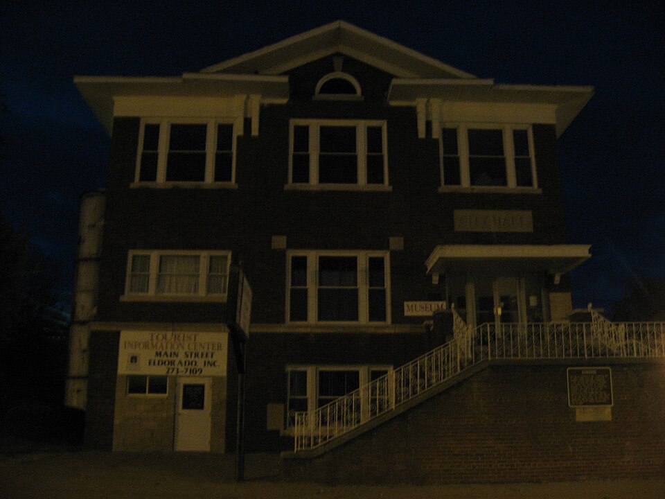
Photograph of Eldorado City Hall
Photograph by Nyttend, Public domain. Via Wikimedia Commons.

Eldorado City Hall

Listed on the National Register of Historic Places in 1995.

From the record

“The Eldorado City Hall, located at 1604 Locust St., is the former city hall of Eldorado, Illinois. Built in 1924, the building was Eldorado's first city hall; prior to its construction, the city government had been operated from the mayors' businesses.”

Wikipedia article Eldorado City Hall, CC BY-SA 4.0.

One of 4 National Register listings published here for Saline County · listed in 1995 · category: Building.

Sources: the Wikipedia article · the case file at the National Archives · the National Register database, National Park Service

The listing

  • What is counted as historic. The nomination lists 1 building as contributing to the listing.
  • Address. 1604 Locust St., Eldorado, 62930
  • When was it listed? November 1995
  • Category. building
  • Township. East Eldorado township
  • Architectural style. Neoclassical architecture
  • National Register reference number. 95001237 - the number the National Park Service assigned this property when it was listed, and the key its nomination file is catalogued under at the National Archives.

Storms near this property

23 since 1996

Regional context, not property-specific evidence. The National Weather Service names Eldorado, the town this property stands in, in 23 storm reports between 1996 and 2025: 10 thunderstorm wind, 6 hail, 3 flash flood, 2 funnel cloud. No death or injury is recorded in these reports. Each account below is quoted exactly as the forecast office filed it, from the NOAA Storm Events Database, and each date opens the federal record of that event.

WhenEvent Place namedHarm What the report says
January 2008Thunderstorm WindEldorado$200,000Damage was reported between Raleigh and Eldorado. Two mobile homes were destroyed. The steeple of a church was blown off in Eldorado. A large tree fell onto a car. An outbuilding was destroyed, and a large tree fell on the corner of a house. Several houses lost pieces of roofing. A carport was lifted and blown onto a van. An oil-filled tank overturned and spilled oil. About 30 homes and businesses reported roof damage across the county, and another 30 were suspected of not reporting or not detecting damage. Downed trees and power lines were reported along Hilltop Road and U.S. 45. Widespread tree damage occurred throughout the county.
May 2011Thunderstorm WindEldorado$100,000A 100-year-old oak tree was uprooted, taking power and phone lines down. The tree roots damaged a water main, causing water levels in the town's water tower to drop sharply. Numerous streets were blocked by downed trees and limbs around town. Four power poles were broken by downed trees. In downtown Eldorado, hundreds of roofing shingles littered the streets.
May 2011Thunderstorm WindEldorado$50,000At least five large trees were blown down. One house was damaged by a large tree that fell on it. Tree limbs fell on streets and other city property.
July 2002Thunderstorm WindEldorado$25,000Numerous trees and power lines were blown down. Minor roof damage occurred to some homes. The roof was blown off a metal structure.
May 2020Thunderstorm WindEldorado$5,000One tree fell on a power line and knocked out power near the city limits of Eldorado.
August 2005Flash FloodEldorado$5,000Flooding was reported on almost every street in town. In downtown Eldorado, floodwaters were two to three feet deep in places. Floodwaters entered at least one business, but no major damage was reported. Rainfall was estimated around one inch within 30 minutes.
August 2000Thunderstorm WindEldorado$5,000Tree limbs fell on power lines.
July 2012Thunderstorm WindEldorado$3,000Power lines were blown down.
February 2025HailEldorado-A report of hail up to 0.75 in diameter was reported via MPING.
March 2023Flash FloodEldorado-Water was over roads in town.
August 2019HailEldorado-Intermittent quarter-size hail fell near Eldorado Reservoir.
April 2018HailEldorado-Heavy pea to penny-size hail was reported.
April 2010Heavy RainEldorado-Standing water was over State Route 142 at a couple of locations just south of Eldorado. There was a major vehicle accident at one of the locations. Several roadways in eastern Saline County were under water.
July 2009Heavy RainEldorado-Water was over two main roads, including Highway 142.
May 2006Thunderstorm WindEldorado-Trees and large limbs were down in several residents' yards.
July 2006Thunderstorm WindEldorado-A trained spotter estimated wind gusts to 60 MPH at the intersection of U.S. Highway 45 and Route 142. Several tree limbs were blown down, including at least one very large one.
April 2014HailEldorado-no account filed
May 2006HailEldorado-no account filed
April 2005HailEldorado-no account filed
April 2005Funnel CloudEldorado-no account filed
May 2004Flash FloodEldorado-no account filed
June 2004Funnel CloudEldorado-no account filed
July 1996Thunderstorm WindEldorado-no account filed

Every storm recorded in Saline County

Map coverage status

No historic map-sheet match is published for this property yet. That does not mean no map exists. This record needs a coordinate-quality review before it can be joined to a sheet boundary. Browse the county's mapped places while that work is pending.

Listed places nearby

1 within 8 miles

Other National Register properties close enough to walk or drive between, ordered by distance from this one. Both positions come from the same geocoding pass that matched these properties to their map sheets.

Photograph PropertyDistance Listed
Harrisburg City Hall7.3 miles1998

Sources for this property

National Archives recordThe nomination case file for reference 95001237 in Record Group 79.
Wikipedia articleCommunity-written account of this property, licensed CC BY-SA.
Saline CountyAll 4 listed properties in this county.

Provenance

  • Listing record. National Park Service National Register of Historic Places, listed-properties dataset, current to 2026-05-22.
  • Map join. Address geocoded through the United States Census geocoder, then tested against the published boundary of every sheet in the USGS Historical Topographic Map Collection.
  • How this page is made. Listing fields come from federal records; map-sheet coverage is a labelled coordinate-to-boundary calculation, not a source-field claim.
  • Storms. NOAA National Centers for Environmental Information, Storm Events Database https://www.ncei.noaa.gov/stormevents/ A work of the United States government, no copyright under 17 U.S.C. 105. Narratives are quoted verbatim from the National Weather Service report and are not edited or summarised.