 Block
From the record
4 National Register listings published here.
Sources: the National Register database, National Park Service
55 topographic sheets cover 39 settlements here, and 4 properties are on the National Register of Historic Places.
4 National Register listings published here.
Sources: the National Register database, National Park Service
Every property in this county listed on the National Register of Historic Places, with the year it was listed and the federal nomination document.
| Photograph | Property | Type | Listed | Reference |
|---|---|---|---|---|
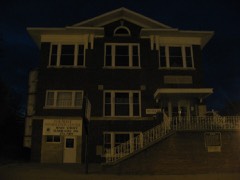 | Eldorado City Hall | building | 1995 | 95001237 |
 | Harrisburg City Hall | building | 1998 | 98001356 |
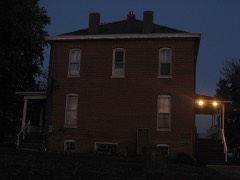 | Saline County Poor Farm | district | 2001 | 00001048 |
Every wildfire the federal occurrence database records inside this county: 56 of them, burning about 1,870 acres. None started naturally and 15 were recorded as arson. Each settlement page carries the fires within five miles of it.
| Reported cause | Fires |
|---|---|
| Missing data/not specified/undetermined | 16 |
| Debris and open burning | 16 |
| Arson/incendiarism | 15 |
| Recreation and ceremony | 5 |
| Equipment and vehicle use | 3 |
| Power generation/transmission/distribution | 1 |
The five largest, by the area the report gives. Three of them were set deliberately.
| Date | Cause | Size | Reported by | Name on the report |
|---|---|---|---|---|
| 5 March 2009 | Equipment and vehicle use | 1,000 acres | Illinois Division of Forestry Resources | MASSEY |
| 5 March 2009 | Missing data/not specified/undetermined | 160 acres | Crab Orchard National Wildlife Refuge | RALEIGH |
| 20 March 2005 | Debris and open burning | 115 acres | Shawnee National Forest | WIEDEMAN HOLLOW |
| 2 November 1994 | Arson/incendiarism | 110 acres | Shawnee National Forest | WAMBLE 2 |
| 3 October 2007 | Missing data/not specified/undetermined | 100 acres | Shawnee National Forest | MINE |
| 18 March 1995 | Arson/incendiarism | 88 acres | Shawnee National Forest | WAMBLE MTN. III |
| 4 April 1994 | Arson/incendiarism | 80 acres | Shawnee National Forest | not named |
| 5 March 2009 | Debris and open burning | 35 acres | Shawnee National Forest | RICE RD, |
Every settlement page carries the fires within five miles of it - see the settlement index below.
The NOAA Storm Events Database holds 321 reports for this county, causing 9 deaths, 104 injuries and about $37,052,780 in recorded property damage. Each settlement page carries the reports that name it.
| Kind of event | Reports |
|---|---|
| Thunderstorm Wind | 144 |
| Hail | 78 |
| Flash Flood | 43 |
| Tornado | 18 |
| Flood | 18 |
| Heavy Rain | 15 |
| Funnel Cloud | 5 |
The most serious of them, by death, then injury, then recorded damage. The accounts are quoted exactly as the forecast office filed them.
| When | Event | Place named | Harm | What the report says |
|---|---|---|---|---|
| February 2012 | Tornado (EF4) | Carriers Mills | 8 killed, 95 hurt, $2,000,000 | The tornado touched down about a mile north of Carrier Mills, then moved east-northeast through Harrisburg. The violent tornado produced a swath of devastation in south and southeast parts of Harrisburg. In Harrisburg, over 200 homes and about 25 businesses were heavily damaged or destroyed. The damage was in residential neighborhoods in the far south and southeast sections of Harrisburg. The commercial strip along U.S. Highway 45 in the south part of the city was directly impacted. A strip mall on the east side of U.S. Route 45 was destroyed. The tornado struck the Harrisburg medical center and surrounding residences on the southeast side of town. At least ten homes or other buildings were levelled, with several home structures displaced from their foundations. The neighborhood with the levelled homes and fatalities was adjacent to the destroyed strip mall. The tornado proceeded across Illinois Route 13 a few miles east of Harrisburg, destroying a farm house and a business. Hundreds of large trees were snapped or uprooted, along with many downed power lines. Peak winds were estimated near 180 mph based on numerous levelled and displaced homes. The average path width was 275 yards. The tornado continued into Gallatin County shortly after crossing Highway 142. |
| May 2017 | Flood | Pankeyville | 1 killed, $30,000 | The middle fork of the Saline River remained flooded for much of the month. An elderly man drowned after driving around barricades to a bridge over the river. The man's truck was washed off the road in the area of the bridge. The incident occurred on a county road southeast of Harrisburg. |
| April 2002 | Tornado (F2) | Galatia | 3 hurt, $3,500,000 | The tornado struck Galatia directly, damaging about 55 structures and destroying several. Peak winds were estimated between 120 and 130 MPH. The roof of a car wash was blown off, and then the walls collapsed on a police cruiser that was sheltered there. A coal mine sustained a quarter million dollars in damage. Two persons were injured in an overturned trailer. Two brick homes lost their roofs and some walls. |
| March 1961 | Tornado (F2) | not stated | 2 hurt, $250,000 | no account filed |
| April 2024 | Tornado (EF2) | Grayson | 2 hurt, $225,000 | An EF-2 tornado occurred approximately two miles southeast of Eldorado during the early morning hours of Tuesday, April 2nd. The tornado began near the intersection of Highway 142 and Ridgway Road. Here, the tornado destroyed an outbuilding, uprooted several large trees, and removed portions of the roofs of two homes. Crossing Ridgway Road and the intersection of White Road, the tornado severely damaged an industrial garage and two manufactured homes. One manufactured home was moved several feet off its foundation and had one of its walls torn open. Two occupants of the home suffered laceration injuries due to flying debris. About five large hardwood trees just behind this home were all snapped at the base. Moving east-southeast, the tornado lifted near Dusty Road just south of Ridgway Road. Peak winds were estimated at 115 mph. |
| January 2013 | Tornado (EF2) | Galatia | 2 hurt, $200,000 | One home was destroyed. The home was unroofed, and three out of four exterior walls collapsed. Several homes sustained roof damage, including roof decking. Windows were blown out of at least one house. A poorly constructed garage and an awning were destroyed. A machine shed was levelled, and the doors were blown out of another one. One home lost a brick chimney. A hay bale feeder was thrown 250 yards. Huge trees up to 14 feet in circumference were uprooted and snapped. There was an eyewitness to the funnel cloud. One person was critically injured by a large tree which fell on his mobile home, trapping him inside. Another person received minor injuries. The average path width was 100 yards. Peak winds were estimated near 115 mph. |
| March 2008 | Flood | Galatia | $16,800,000 | Over 16 million dollars in damage occurred to homes and businesses in Harrisburg due to disastrous flooding. Five homes and one business were considered destroyed. At least 30 homes and 44 businesses had water over the first floor. All three of the supermarkets in the city were closed due to flooding. Eighteen homes and three businesses reported water in the basement, though many others likely did not report basement flooding. About 300 residents of the city were evacuated, many to a Red Cross shelter. Emergency personnel evacuated at least one family from flooded areas outside the city. Many streets were closed in Harrisburg. U.S. Highway 45 was closed for days. Significant damage occurred to roads countywide. Four feet of water covered the basement of a church in Carrier Mills. Access to the local Harrisburg hospital was blocked by floodwaters, closing it for a short time. In Carrier Mills, 17 homes were flooded, five more had flooded basements, and vehicles and sheds were submerged. A major problem in Carrier Mills was contamination of the wells that supply public drinking water. Residents were urged to boil water before using it. Utilities were shut off to the hardest hit flood zones. A makeshift levee about seven feet tall was constructed on State Route 34 to protect parts of Harrisburg from renewed flooding of the Saline River. The levee worked, even though a vehicle drove through barricades and struck the levee. The main water line to Galatia broke, and residents were urged to boil their water. Near Stonefort, a railway was washed out. About 100 basements were flooded in Eldorado. |
| May 2009 | Thunderstorm Wind | Newhope | $4,500,000 | Widespread wind damage occurred across the county. The pockets of greatest damage were in northern parts of the county including Galatia and Raleigh, as well as southwestern parts around Carrier Mills. Harrisburg itself escaped the worst of the damage, and power outages there only affected several hundred customers. Winds were estimated near 90 mph in the Harco area. Extensive power outages lasted three to six days in the hardest hit areas, including Galatia. The power losses rendered pumping stations that supply water inoperable. Many structures were damaged. Every street in Galatia had trees down across streets, houses, vehicles, or outbuildings. Two homes in Galatia received major damage. Barns were destroyed in the Harco area. A mobile home used as a school for the Amish blew off its foundation. Some roofs were blown off. Other structures were damaged by falling trees. A semi was blown over north of Harrisburg on Illinois 34. Emergency responders had difficulty reaching the scene due to downed trees. Many roads were closed by downed trees and power lines, including major routes such as Illinois 34 and U.S. Highway 45. A state disaster declaration included Saline County. |
| May 1996 | Flash Flood | Harrisburg | $1,500,000 | no account filed |
| April 1996 | Flash Flood | Harrisburg | $1,500,000 | no account filed |
| May 2024 | Flash Flood | Beulah Hgts | $800,000 | Significant flash flooding occurred in Eldorado. Ferrell Hospital sustained floodwater damage with 55,000 sq ft of the hospital affected, requiring transfer of patients to other facilities. Flooding on roads leading to the hospital hindered emergency crews. Several streets around the city flooded, and water intruded into the Eldorado High School entrance. Torrential rainfall rates produced radar estimated 1.5-2 inches of rain in Eldorado, with most of the rain occurring between 1515-1615CST. Flash flooding transitioned to a flood event through the evening. |
| April 2018 | Tornado (EF2) | Banlick | $500,000 | The tornado entered Saline County from Williamson County. In Saline County, three homes were destroyed. The peak intensity occurred between the Williamson County line and Galatia, where a single-wide mobile home was completely demolished. A well-built house was completely unroofed, and portions of the exterior walls collapsed. Peak winds were estimated near 125 mph at this location. Over a dozen other homes were damaged, with at least partial loss of shingles and siding. A couple dozen barns and pole barns were destroyed or heavily damaged. Hundreds of trees were snapped or uprooted. |
| May 2009 | Thunderstorm Wind | Harrisburg | $400,000 | This microburst struck a 10-block long area in the city of Harrisburg, from the southwest edge of town to the southeast side. The damage ended after striking the commercial strip on U.S. Highway 45. The damage swath was about one-half mile wide. Porches were blown off a couple of housees. Trees up to two feet in diameter fell on houses. Some power lines were down. The wind caused some direct minor structural damage to houses. The press box at a football field was blown out of the stands. A construction trailer was blown on its side. Storage sheds and outbuildings were blown over, including one shed that struck and damaged a few vehicles. A gas station canopy was heavily damaged. |
| May 2004 | Thunderstorm Wind | Countywide | $310,000 | no account filed |
| July 2024 | Flash Flood | Harrisburg Arpt | $250,000 | Flash flooding occurred in and around Eldorado. Water rescues occurred in the city. Several dozen homes and businesses, along with Ferrell Hospital, sustained some water intrusion. Several roads were closed due to flooding in the north half of Saline County. Radar estimated rainfall from Raleigh to Eldorado was 3 to 5 inches between 1900-2200CST. |
| April 2011 | Thunderstorm Wind | Beulah Hgts | $250,000 | Extensive damage occurred just to the south and east of Eldorado. A tree fell across a house, a barn and a grain bin were destroyed, and a mobile home was flipped over. Some roofs were damaged in the Eldorado area. Three power poles were knocked across Illinois Route 142. Trees were blown down, including some that landed across roads. Due to tree and power line damage, much of Eldorado was without power into the following day. |
| October 1990 | Tornado (F1) | not stated | $250,000 | no account filed |
| January 1975 | Tornado (F2) | not stated | $250,000 | no account filed |
| April 2014 | Flash Flood | Harrisburg | $200,000 | Widespread flash flooding occurred in the cities of Harrisburg and Eldorado. Multiple streets were under water and residences were flooded in Harrisburg. Most of the flooding occurred on the southeast side of town. In Eldorado, vehicles were stranded and several homes were evacuated. Vehicle rescues were performed along U.S. Highway 45. Sections of Route 45 were under one to two feet of water. Several businesses received water damage. |
| January 2008 | Thunderstorm Wind | Eldorado | $200,000 | Damage was reported between Raleigh and Eldorado. Two mobile homes were destroyed. The steeple of a church was blown off in Eldorado. A large tree fell onto a car. An outbuilding was destroyed, and a large tree fell on the corner of a house. Several houses lost pieces of roofing. A carport was lifted and blown onto a van. An oil-filled tank overturned and spilled oil. About 30 homes and businesses reported roof damage across the county, and another 30 were suspected of not reporting or not detecting damage. Downed trees and power lines were reported along Hilltop Road and U.S. 45. Widespread tree damage occurred throughout the county. |
| November 2005 | Thunderstorm Wind | Harrisburg | $200,000 | On Old Route 13 just east of Harco Road, several power poles were snapped. Near the airport just west of Raleigh, a barn and outbuilding were damaged, and a greenhouse was destroyed. An auger was tipped over and destroyed, and a tractor and combine were damaged by flying debris. In Raleigh, a portion of a church's roof was peeled off, and a few outbuildings were destroyed. |
| August 2007 | Thunderstorm Wind | Harrisburg | $150,000 | Numerous trees were blown down from Harrisburg south to the county line. At the county fairgrounds in Harrisburg, the grandstands were heavily damaged, fencing was damaged, and utility poles were down. Trees landed on a cattle barn and concession stand. Elsewhere around the city, doors and windows of four businesses were blown out. A garage partially collapsed. Portions of the roof were lifted off an auto body shop and a utility service building. Large trees were uprooted and power lines were down in Harrisburg. |
| June 2007 | Thunderstorm Wind | Galatia | $125,000 | Extensive wind damage occurred in northwest and north central Saline County. A carport was blown on top of a mobile home. The wall of the mobile home was punctured by the carport. A large tree limb landed on the mobile home. Parts of a metal roof were peeled off another home. A large number of trees were down through the area. One tree landed on a pickup truck. Approximately 20 trees were uprooted or snapped in and around a cemetery. Some of the trees were greater than two feet in diameter. There was damage to cemetery buildings, including a chapel, gazebo, and outbuilding. Window panes were blown out of an adjacent church built in 1906, and cross beams were broken around the bell tower. A moving vehicle struck a downed tree at least 2 feet in diameter on Route 34. The driver was taken to a local hospital for a leg injury. The pattern and orientation of the damage suggested downburst winds. |
| August 2019 | Hail | Galatia | $100,000 | A narrow swath of very large hail up to 3.5 inches in diameter occurred across northern Saline County. The biggest hailstone was photographed alongside a ruler. The biggest hailstones and associated damage were in farmland just north of the communities of Galatia and Raleigh. Two roofs were damaged 3.5 miles north-northwest of Galatia. A truck roof was dented, and there were some minor dents in cars. A window was broken out of a tractor cab. A few lights were knocked out. Some crop damage occurred north of Galatia. A local emergency manager and insurance agent confirmed that damage reports were scant. This may be attributable to the very sparse population of the area. Another possibility is that the very large hailstones were few in number compared to a prolific amount of small hail. |
| May 2011 | Thunderstorm Wind | Eldorado | $100,000 | A 100-year-old oak tree was uprooted, taking power and phone lines down. The tree roots damaged a water main, causing water levels in the town's water tower to drop sharply. Numerous streets were blocked by downed trees and limbs around town. Four power poles were broken by downed trees. In downtown Eldorado, hundreds of roofing shingles littered the streets. |
| April 2011 | Thunderstorm Wind | Harrisburg | $100,000 | Buildings in the downtown area suffered minor damage, such as pieces of roofing blown off. Two windows of a downtown storefront were broken. Scaffolding around a downtown commercial building was blown down. A carport blew into a power line. A chimney was blown down. An antenna tower used for fire department radio communications was blown over. Many trees were blown down, including a few on power lines. |
| February 1999 | Thunderstorm Wind | Harrisburg | $100,000 | A severe thunderstorm struck parts of Harrisburg with winds estimated near 80 MPH. A roof was blown off a house, and windows were blown out of a business. Signs were blown down or damaged, and a car was blown off the road. In downtown Harrisburg along Route 13, three businesses sustained major roof damage. An auto parts store lost a quarter of its roof, which damaged about a quarter of its inventory. |
| June 1998 | Thunderstorm Wind | Harrisburg | $100,000 | A thunderstorm produced wind gusts estimated near 100 MPH in Harrisburg. Hundreds of trees were uprooted or snapped. Some of the trees were up to 5 feet in diameter. Several utility poles were blown over or snapped. A few storage barns and garages were blown off their foundations. Weak structures such as small sheds were completely destroyed. Numerous power lines were down, knocking out power to an estimated 35,000 people. The damage path ranged from 3/4 to 1 mile wide, and between 4 and 5 miles long. |
| May 2024 | Thunderstorm Wind | Carriers Mills | $80,000 | A broad area of straight-line wind damage, primarily from the rear-flank downdraft of a supercell storm, occurred south of Carrier Mills. Tree branch damage occurred on US Hwy 45 and Tuller Rd while more significant tree damage occurred on Pankey Rd and Taborn Rd with uprooted trees. A large span chicken house collapsed on Walnut Grove Rd. |
| May 2024 | Tornado (EF1) | Ledford | $80,000 | An EF-1 tornado formed southeast of Carrier Mills with tree damage north of Walnut Grove Rd. The tornado tracked east-southeastward. Several dozen trees were snapped or uprooted along with many large branches broken along the path. A few homes and barns with minor roof damage. One home was slightly shifted off its foundation on Walnut Grove Rd. The heaviest concentration of tree damage was on Willow Grove Rd. Damage became more sparse as the tornado crossed fields east of Hwy 145, with tree damage visible on the South Fork Saline River. Additional tree damage occurred in Somerset, with the tornado lifting at Shawnee Rd. Peak winds with this tornado were estimated at 95 mph. Many locations experienced straight-line wind damage north and south of the track from inflow regions of the supercell. |
| May 2011 | Thunderstorm Wind | Harrisburg | $80,000 | In Harrisburg, numerous trees were blown down, and signs were blown over. Several roofs were damaged. Siding was ripped off a building. The area of greatest damage was in a neighborhood on the southeast side of Harrisburg, where a microburst about one mile long and one-third mile wide downed hundreds of trees and limbs. A garage was flattened by an uprooted tree. Winds in the microburst were estimated near 75 mph. A trained spotter seven miles west of Harrisburg estimated winds gusted to 60 mph. |
| January 1999 | Flood | Countywide | $80,000 | Heavy rains from a succession of thunderstorms produced 2 to 3 inches of rain across much of Saline County, including 2.42 inches at the Harrisburg Sewer Plant. Rural county roads were heavily damaged by the runoff. Several roads had water over them for extended periods of time. A few road washouts and road closures were reported. |
| September 2025 | Thunderstorm Wind | Pankeyville | $75,000 | Delayed report. An anchored single-wide trailer was overturned and partially collapsed by thunderstorm downburst winds on Brier Creek Road. Nearby mature corn rows were also blown down. Thunderstorm winds are estimated to be around 80 to 90 mph. |
| April 2024 | Tornado (EF1) | Stonefort | $75,000 | This EF-1 tornado began in Williamson County during the early morning hours of Tuesday, April 2nd, crossing over into Saline County in the middle of Stonefort. The tornado continued to produce tree and roof damage in Stonefort, then proceeded eastward along Battleford Rd damaging a few more trees before lifting around a mile east of Stonefort, past the railroad crossing on Brattleford Rd. Estimated peak wind gusts in the Saline County portion of this tornado were 105 mph. |
| May 2024 | Flash Flood | Harrisburg | $75,000 | Training thunderstorms produced significant street flooding in Harrisburg. Floodwaters were estimated at 6 to 12 inches deeper than usual for floodprone streets. Water crossed U.S. 45 south of Harrisburg. The fire department was dispatched to a car floating in a Walmart parking lot. Roughly 2-3 inches of rain (radar estimates were 3-4 inches but hail contamination is likely) fell within 2 hours between 1800-2000CST. |
| May 2024 | Thunderstorm Wind | Mitchellsville | $75,000 | An Eagle Coal metal structure collapsed as a result of rear flank downdraft winds just south of a tornado track. |
| August 2020 | Thunderstorm Wind | Raleigh | $75,000 | Trees and power lines were down. Some roof damage occurred. Power was out. The area of damage was mainly near and north of Harrisburg. |
| November 2005 | Flash Flood | Countywide | $75,000 | A spotter measured 8.5 inches of rain from overnight thunderstorms in Galatia, on the north end of the county. On the south end, only 3.22 inches unofficially fell at Carrier Mills. Numerous roads had water over them, including primary roads such as U.S. Route 45 near Ledford. In Harrisburg, streets were barricaded, and there was considerable flooding of yards and fields. Residents of a nursing home in Harrisburg were moved from their rooms after one wing of the facility flooded. A few basements were flooded. |
| October 2013 | Tornado (EF1) | Stonefort | $70,000 | This tornado, which began in Williamson County, crossed into Saline County near Stonefort. The tornado contained estimated peak winds near 100 mph. Three barns and four homes were damaged. The damage consisted mainly of roof damage, including one home with its roof torn off. Numerous trees were uprooted and snapped. Power lines were blown down. |
| May 2012 | Thunderstorm Wind | Muddy | $60,000 | Trees were blown down. Some trees landed on houses and power lines. Traffic was stopped by debris. Wind-driven hail contributed to some of the damage. |
| July 2012 | Thunderstorm Wind | Carriers Mills | $60,000 | The roof was blown off a building onto a street. Building debris was in the roadway on U.S. Highway 45. Shingles were blown off houses. Several large trees were blown down, including one that landed on a street. |
| May 2011 | Flood | Rileyville | $60,000 | no account filed |
| May 2024 | Flash Flood | Harrisburg | $50,000 | Significant flash flooding occurred in Harrisburg. Several roads flooded with cars stuck in water. Most of the softball field flooded. Torrential rainfall rates produced radar estimated 1.5-2 inches of rain in Harrisburg, with most of the rain occurring between 1515-1615CST. Flash flooding transitioned to a flood event through the evening. |
| June 2018 | Thunderstorm Wind | Galatia | $50,000 | Widespread wind damage occurred across the county. Numerous trees and power lines were down, causing widespread power outages. A large tree blocked Route 34, and a sign was blown apart at the Harrisburg-Raleigh Airport. |
| May 2011 | Thunderstorm Wind | Eldorado | $50,000 | At least five large trees were blown down. One house was damaged by a large tree that fell on it. Tree limbs fell on streets and other city property. |
| December 2008 | Thunderstorm Wind | Harrisburg | $50,000 | One building in Harrisburg lost its roof. A business in Raleigh lost one fourth of its roof. Large trees were down, blocking Highway 34. |
| June 1995 | Thunderstorm Wind | Countywide | $50,000 | Many trees were downed. Several trees fell on roads, houses, and power lines. The rubber top of the roof of the Harrisburg City Hall was peeled back, causing about $10,000 damage. Part of the wall extending above the city hall roof was broken by the wind. Power outages were widespread, and not all power was restored until early the next day. Shingles were blown off roofs in Eldorado. Also in Eldorado, a tree fell on a truck. |
| August 2009 | Thunderstorm Wind | Carriers Mills | $40,000 | The roof was peeled off a mobile home in Carrier Mills. Several trees and power lines were blown down in Harrisburg. One large oak tree landed across a street and power lines, closing the street for a few hours. |
| August 2005 | Thunderstorm Wind | Harrisburg | $40,000 | Wind gusts estimated from 55 to 60 MPH downed trees and power lines. At least a half dozen trees were knocked down in Eldorado. Several of the trees fell across houses and garages. One tree fell on a swimming pool. Numerous tree limbs and small trees fell across Harrisburg streets. |
| May 2000 | Thunderstorm Wind | Harrisburg | $40,000 | A thunderstorm microburst produced strong damaging winds, estimated between 75 and 80 MPH. Several mobile homes in a rural area just south of Route 13 near the Gallatin County line were affected by the microburst, which was about 1/4 mile wide and 1/2 to 3/4 mile long. One mobile home was destroyed when a tree about 2.5 feet in diameter fell on it. On another mobile home, about 3/4 of a 60-foot attached screened-in porch was torn off. A third mobile home used for storage was moved a few feet off of its foundation. A nearby house lost some shingles and gutters. Several hundred trees in the area were blown down. |
| April 2015 | Thunderstorm Wind | Galatia | $35,000 | Damaging winds swept across northern Saline County. In Galatia, large tree limbs were blown down. In Raleigh, law enforcement personnel estimated a wind gust of 65 to 70 mph downed a tree. In Eldorado, a tree was down on a trailer home. |
| April 2017 | Flash Flood | Harrisburg | $30,000 | Widespread flash flooding of streets occurred throughout the Harrisburg area, including about 10 square blocks that were impassable in the city. A trained spotter in Eldorado measured 5.25 inches in the overnight storms. |
| July 2006 | Thunderstorm Wind | Countywide | $30,000 | Numerous trees and power lines were down countywide. A tree fell on a dump truck on Route 142 about three miles south of Eldorado. Another tree fell on a car. |
| June 1995 | Hail | West End to Muddy | $30,000 | About 340 cars were damaged at a car dealership in Muddy. State police reported golf ball-size hail in Eldorado. |
| May 2024 | Thunderstorm Wind | Rudement | $25,000 | Straight-line thunderstorm winds to the south of a tornado track blew down a barn off of Williams Rd. |
| July 2023 | Thunderstorm Wind | Harrisburg | $25,000 | Numerous trees were blown down in the county. There were eleven different calls for trees and power lines down in Harrisburg alone. |
| July 2016 | Thunderstorm Wind | Galatia | $25,000 | Trees were down on homes, with damage reported. There were local power outages. |
| July 2002 | Thunderstorm Wind | Eldorado | $25,000 | Numerous trees and power lines were blown down. Minor roof damage occurred to some homes. The roof was blown off a metal structure. |
| December 1957 | Tornado (F2) | not stated | $25,000 | no account filed |
| May 2024 | Thunderstorm Wind | Ledford | $20,000 | Straight-line wind damage on the north end of a tornado track was found along Blue Hole Rd, Feazel Rd, Butler Rd, and Willow Grove Rd. Tree damage generally fell towards the south or southeast. The most significant damage was an uprooted tree which fell onto a house. |
The Survey's mineral resources record lists 13 workings inside this county. 1 still produces and 12 are closed or unrecorded. Each settlement page carries the workings within five miles of it.
| Commodity | Workings |
|---|---|
| Fluorine-Fluorite | 6 |
| Stone, Crushed/Broken | 4 |
| Barium-Barite | 2 |
| Clay | 1 |
The least common of them first, because a county's hundredth gravel pit says nothing its first ten did not.
| Where | Site | Commodity | Status | Recorded |
|---|---|---|---|---|
| Harrisburg Grick and Tile Co. Clay | Clay | Past Producer | ||
| Barite Porspect Number 1 | Barium-Barite | Occurrence | ||
| Barite Porspect Number 1 | Barium-Barite | Occurrence | ||
| Downstate No. 1 | Stone, Crushed/Broken | Producer | ||
| Harrisburg City Eng. | Stone, Crushed/Broken | Past Producer | ||
| Limestone Prospect | Stone, Crushed/Broken | Occurrence | ||
| Saline Highway Department | Stone, Crushed/Broken | Past Producer | ||
| Big Four Mine | Fluorine-Fluorite | Past Producer | ||
| Big Four Mine | Fluorine-Fluorite | Past Producer | ||
| Gibbons Mine | Fluorine-Fluorite | Occurrence | Fluorite | |
| Gibbons Mine | Fluorine-Fluorite | Prospect | ||
| King | Fluorine-Fluorite | Occurrence | Fluorite, Galena, Sphalerite | |
| King | Fluorine-Fluorite | Prospect |
Named settlements recorded in the Geographic Names Information System, each with the topographic sheets covering it. Villages, hamlets and abandoned places alike. Each is shown with the nearest named watercourse or landform and the survey quadrangle it falls on.
Carrier Mills township · 62987 · On Brier Creek · Carrier Mills quadrangle
22 sheets, 1925 to 1996
Mountain township · 62947 · Near Rocky Branch Hollow · Rudement quadrangle
22 sheets, 1916 to 1996
Harrisburg township · 62946 · On Pankey Branch · Harrisburg quadrangle
20 sheets, 1925 to 1996
Tate township · 62890 · On Halltown Creek · Akin quadrangle
18 sheets, 1908 to 1987
No longer a settlement
Mountain township · 62934 · Near Hargrave Hollow · Rudement quadrangle
22 sheets, 1916 to 1996
Independence township · 62917 · On Old Channel · Harrisburg quadrangle
20 sheets, 1925 to 1996
Cottage township · 62934 · Eldorado quadrangle
17 sheets, 1905 to 1987
No longer a settlement
Independence township · 62946 · Near Mud Springs Hollow · Rudement quadrangle
22 sheets, 1916 to 1996
Carrier Mills township · 62987 · On Black Slough · Carrier Mills quadrangle
22 sheets, 1925 to 1996
Independence township · 62946 · On Spring Valley Creek · Rudement quadrangle
22 sheets, 1916 to 1996
No longer a settlement
Mountain township · 62946 · Near Stillhouse Hollow · Rudement quadrangle
22 sheets, 1916 to 1996
Mountain township · 62946 · On Spring Valley Creek · Rudement quadrangle
22 sheets, 1916 to 1996
No longer a settlement
The vanished settlements of Saline County: the places named above that are no longer on the map.