Listed on the National Register of Historic Places in 1995.
From the record
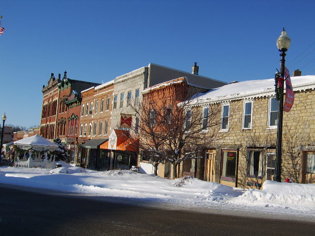
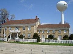
“The Warren Commercial Historic District is a historic commercial district located in Warren, Illinois. The district encompasses the town's central business district and includes 34 contributing buildings and a water tower.”
Wikipedia article Warren Commercial Historic District (Warren, Illinois), CC BY-SA 4.0.
One of 17 National Register listings published here for Jo Daviess County · listed in 1995 · category: District.
National Register reference number.95001241- the number the National Park Service assigned this property when it was listed, and the key its nomination file is catalogued under at the National Archives.
Although Black Hawk's movement across the Mississippi, on the 6th of April, was at once construed into a hostile demonstration, and Davenport skillfully cultivated the idea, he was accompanied by his old men, women and children. !N"o Indian warriors ever went on the war path encumbered in that way. More than this, it does not appear, from the sixth <lay of April until Stillman's drunken soldiers fired on his flag of truce, on the 12th of May, that a single settler was murdered, or sufiered any material injury at the hands of Black Hawk or his band. In truth, Hon. H. S. Townsend, of Warren, states that in one instance, at least, where they took corn from a settler, they paid him for it. Capt. W. B. Green writes: " 1 never heard of Black Hawk's band, while passing up Rock River, committing any depredation whatever, not even petty theft." Frederick Stahl, Esq., of Galena, states that he was informed by the veteran John Dixon, that " when Black Hawk's band passed his post, before the arrival of the troops, they were at his house. Ne-o-Pope had the young braves well in hand, and informed him that they intended to commit no depredations, and should not fight unless they were attacked."
John S. Miller's house* was known as " Miller's tavern," and was situated on or near the corner of what is Branch and Dodge Streets, in that part of the city called " Old Town." On the same day the above order was entered, the following named citizens and voters were selected to serve as petit jurors : James Craig, John Chandler, Thomas Gray, Francis Kirkpatrick, John Barrel], James Smith, Thomas Drum, Joseph Hardy, John Kay, William Henry, James Langworthy, Samuel Whitesides, Martin Warren, Moses Eastman, James Cherry, James Kindall, Adam Hymer, Thomas Hymer, Peter Carr, George Ferguson, William H. Smith, James Brady, Enoch Wethers and William Brazier.
Regional context, not property-specific
evidence. The
federal wildfire occurrence database
lists 10 fires within 5 miles of Warren Commercial Historic District
between 2004 and 2019, burning about 27 acres in total. None started naturally. None was recorded as arson.
Distance is straight-line from the map coordinates, so a fire counted
here may appear on a neighbouring settlement's page as well.
Reported cause
Fires
Missing data/not specified/undetermined
7
Recreation and ceremony
1
Equipment and vehicle use
1
Debris and open burning
1
The most recent of
them, most recent first, with the day each was reported and the service
that recorded it.
Regional context, not property-specific
evidence. The federal mineral resources record lists
4 workings within 5 miles of Warren Commercial Historic District: 3 past producers, 1 producer.
1 still produces. What was taken out: Stone, Crushed/Broken. Distance is straight-line from the
map coordinates, so a quarry counted here may appear on a neighbouring
settlement's page as well.
Regional context, not property-specific
evidence. The National Weather Service names
Warren, the town this property stands in, in 30 storm reports between 2000 and 2026: 17 thunderstorm wind, 9 hail, 1 heavy rain, 1 flash flood.
The reports record 1 injury. Each account below is quoted exactly as the forecast office
filed it, from the NOAA Storm Events Database, and each date
opens the federal record of that event.
Winds estimated to be 70 mph blew down trees and power lines. Several trees fell onto some houses. One person was transported to a hospital with a minor injury and later released. Power and phone service was knocked out to about half of the town.
A trained spotter observed a brief tornado in an open field near Warren. The tornado is designated as an EF-U (unknown), as no damage was observed to assign an EF-scale rating.
No historic map-sheet match is published
for this property yet. That does not mean no map exists. This record needs
a coordinate-quality review before it can be joined to a sheet boundary.
Browse the county's mapped places while that work is
pending.
Listed places nearby
2 within 8 miles
Other National Register properties close
enough to walk or drive between, ordered by distance from this one. Both
positions come from the same geocoding pass that matched these properties
to their map sheets.
Listing record. National Park Service National Register of Historic Places, listed-properties dataset, current to 2026-05-22.
Map join. Address geocoded through the United States Census geocoder, then tested against the published boundary of every sheet in the USGS Historical Topographic Map Collection.
How this page is made. Listing fields come from federal records; map-sheet coverage is a labelled coordinate-to-boundary calculation, not a source-field claim.
Wildfire. Short, Karen C. 2022. Spatial wildfire occurrence data for the United States, 1992-2020 [FPA_FOD_20221014]. 6th Edition. Fort Collins, CO: Forest Service Research Data Archive. https://doi.org/10.2737/RDS-2013-0009.6 Collected with United States Government funding and usable without additional permissions or fees.
Mines and quarries. USGS Mineral Resources Data System (MRDS) https://mrdata.usgs.gov/mrds/ A work of the United States government, no copyright under 17 U.S.C. 105.
Storms. NOAA National Centers for Environmental Information, Storm Events Database https://www.ncei.noaa.gov/stormevents/ A work of the United States government, no copyright under 17 U.S.C. 105. Narratives are quoted verbatim from the National Weather Service report and are not edited or summarised.
 Block