BlockBefore
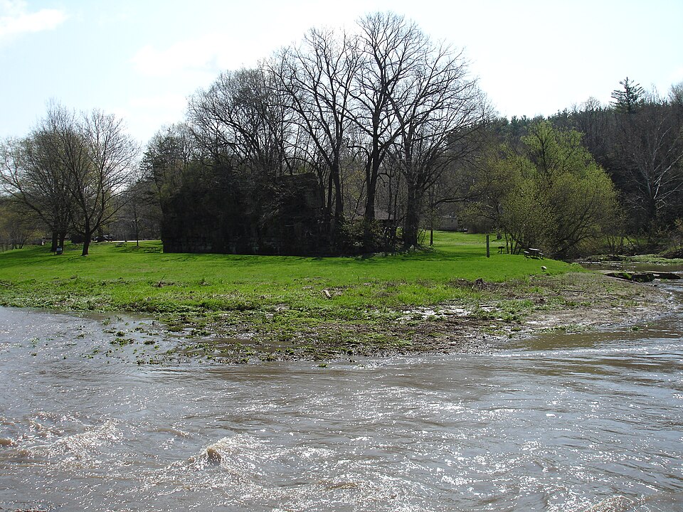
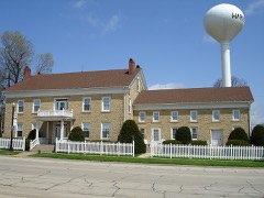
Photograph of Millville
Photograph by IvoShandor, CC BY-SA 3.0. Via Wikimedia Commons.

Millville Town Site

Listed on the National Register of Historic Places in 2003.

From the record

“Millville is a defunct settlement in Jo Daviess County, Illinois, United States, located within the boundaries of Apple River Canyon State Park. Founded in 1835 and platted in 1846, the community was washed away completely by a flood in 1892.”

Wikipedia article Millville, Illinois, CC BY-SA 4.0.

One of 17 National Register listings published here for Jo Daviess County · listed in 2003 · category: Site.

Sources: the Wikipedia article · the case file at the National Archives · the National Register database, National Park Service · the Wikipedia article
The listing

The ground it stands on

8,407 words

The chapter on Rush Township in The History of Jo Daviess County, Illinois, Containing a History of the County, Its Cities, Towns, Etc., a Biographical Directory of Its Citizens, War Record of Its Volunteers in the Late Rebellion ... History of the Northwest, History of Illinois ... Constitution of the United States, published 1878 names Apple River. This is what it says, exactly as the scans read.

In the month of August, 1828, a Mr. Kirker erected the first house that was ever built in the Township of Rush on the old Sucker Trail, running along a branch of Apple River. Mr. Kirker built the house for the purpose of keeping a tavern, but as there was no travel in Winter, the business did not pay, and the would-be landlord left the house to take care of itself. In 1830, he sold his house to Hiram Imus, Jr., who with his wife moved into it.

Passage source: The History of Jo Daviess County, Illinois, Containing a History of the County, Its Cities, Towns, Etc., a Biographical Directory of Its Citizens, War Record of Its Volunteers in the Late Rebellion ... History of the Northwest, History of Illinois ... Constitution of the United States, published 1878.

In 1835, Thomas Burbridge and his two brothers, Rollin and Jackson, accompanied by John R. Smith, ,built a house on Apple River, at a place afterwards called Millville, and moved into it. In the Spring of 1836, they built a saw mill at that place, which was the first saw mill built on Apple River, with the exception of one built by Mr. Craig, at a place then called Wappello, but now known as Hanover. In this saw mill the Burbridges cut a vast amount of lumber, which they sold very readily to the new settlers who were then coming into the country. The Burbridges were all young men. Their mother kept house for them many years. She was a type of the pioneer women of America, and was highly respected by all who knew her. She died in 1874, in the 97 th year of her age.

Passage source: The History of Jo Daviess County, Illinois, Containing a History of the County, Its Cities, Towns, Etc., a Biographical Directory of Its Citizens, War Record of Its Volunteers in the Late Rebellion ... History of the Northwest, History of Illinois ... Constitution of the United States, published 1878.

Machine-read from a century-old scan, so expect the errors a machine makes: misspelled names, dropped words, stray characters.

Read the whole chapter on Rush Township - 8,407 words on its settlement, mills, schools and churches.

Fires near this property

7 since 2008

Regional context, not property-specific evidence. The federal wildfire occurrence database lists 7 fires within 5 miles of Millville Town Site between 2008 and 2010, burning about 16 acres in total. None started naturally. None was recorded as arson. Distance is straight-line from the map coordinates, so a fire counted here may appear on a neighbouring settlement's page as well.

Reported cause Fires
Missing data/not specified/undetermined7

The most recent of them, most recent first, with the day each was reported and the service that recorded it.

DateCause SizeReported by Name on the report
24 May 2008Missing data/not specified/undetermined10 acresIllinois Division of Forestry ResourcesWAND
7 April 2009Missing data/not specified/undetermined1.0 acresIllinois Division of Forestry ResourcesCNR
7 April 2009Missing data/not specified/undeterminedunder an acreIllinois Division of Forestry ResourcesSTAGECOACH
30 April 2008Missing data/not specified/undeterminedunder an acreIllinois Division of Forestry Resources8011
11 April 2009Missing data/not specified/undetermined2.0 acresIllinois Division of Forestry ResourcesGERLACH
22 March 2009Missing data/not specified/undetermined1.0 acresIllinois Division of Forestry ResourcesNIEMANN
17 March 2010Missing data/not specified/undetermined1.0 acresIllinois Division of Forestry ResourcesSCOUT

Every fire recorded in Jo Daviess County

Mines and quarries near this property

7 within 5 miles

Regional context, not property-specific evidence. The federal mineral resources record lists 7 workings within 5 miles of Millville Town Site: 5 past producers, 1 plant, 1 producer. 2 still produce. What was taken out: Stone, Crushed/Broken. Distance is straight-line from the map coordinates, so a quarry counted here may appear on a neighbouring settlement's page as well.

Where SiteCommodity StatusRecorded
Anderson QuarryStone, Crushed/BrokenPast Producer
Mark QuarryStone, Crushed/BrokenPast Producer
Russell QuarryStone, Crushed/BrokenPast Producer
Sweet Home QuarryStone, Crushed/BrokenProducer
Townsend QuarryStone, Crushed/BrokenPast Producer
Westaby QuarryStone, Crushed/BrokenPast Producer
Yungbluth Quarry & MillStone, Crushed/BrokenPlant

Every working recorded in Jo Daviess County

Storms near this property

10 since 1997

Regional context, not property-specific evidence. The National Weather Service names Apple River, the town this property stands in, in 10 storm reports between 1997 and 2019: 7 thunderstorm wind, 3 hail. No death or injury is recorded in these reports. Each account below is quoted exactly as the forecast office filed it, from the NOAA Storm Events Database, and each date opens the federal record of that event.

WhenEvent Place namedHarm What the report says
July 2011Thunderstorm WindApple River$100,000Wind gusts estimated to be 70 mph blew down several large trees and a metal flag pole in Apple River, IL at 620 am CDT July 11. Almost every property in the 400 person town suffered some damage. Information from this report was also attained from a news paper article.
September 2019Thunderstorm WindApple River-A tree was blown down at the corner of Apple River Canyon Road and East Stagecoach road. Report relayed by 911 call center.
July 2016Thunderstorm WindApple River-Local law enforcement reported trees were down along with some power lines near Stagecoach Trail west of Apple River. A tree was also down across the railroad tracks along Stagecoach Trail. Winds were estimated to be up to near 70 MPH.
July 2009HailApple River-Golf ball-sized hail fell in Apple River, IL around 552 pm July 24.
August 2009Thunderstorm WindApple River-Wind gusts estimated to be 65 mph blew down several 10 to 12 inch diameter tree limbs in Apple River, IL around 152 pm August 9.
August 2006HailApple River-The fire department reported penny to nickel size hail that lasted for 1 minute with non-severe wind gusts.
April 2002Thunderstorm WindApple River-Power lines knocked down.
August 2002Thunderstorm WindApple River-Several large trees, at least 2 feet in diameter, blown down in Apple River Canyon State Park.
June 1997Thunderstorm WindApple River-Numerous trees down with diameters up to 12 inches.
May 2000HailApple River-no account filed

Every storm recorded in Jo Daviess County

Map coverage status

No historic map-sheet match is published for this property yet. That does not mean no map exists. This record needs a coordinate-quality review before it can be joined to a sheet boundary. Browse the county's mapped places while that work is pending.

Listed places nearby

4 within 8 miles

Other National Register properties close enough to walk or drive between, ordered by distance from this one. Both positions come from the same geocoding pass that matched these properties to their map sheets.

Photograph PropertyDistance Listed
Townsend House4.7 miles2005
Old Stone Hotel4.9 miles1975
Warren Commercial Historic District5.0 miles1995
W.E. White Building6.7 miles1997

Sources for this property

National Archives recordThe nomination case file for reference 03000066 in Record Group 79.
Wikipedia articleCommunity-written account of this property, licensed CC BY-SA.
Jo Daviess CountyAll 17 listed properties in this county.

Provenance

  • Listing record. National Park Service National Register of Historic Places, listed-properties dataset, current to 2026-05-22.
  • Map join. Address geocoded through the United States Census geocoder, then tested against the published boundary of every sheet in the USGS Historical Topographic Map Collection.
  • How this page is made. Listing fields come from federal records; map-sheet coverage is a labelled coordinate-to-boundary calculation, not a source-field claim.
  • Wildfire. Short, Karen C. 2022. Spatial wildfire occurrence data for the United States, 1992-2020 [FPA_FOD_20221014]. 6th Edition. Fort Collins, CO: Forest Service Research Data Archive. https://doi.org/10.2737/RDS-2013-0009.6 Collected with United States Government funding and usable without additional permissions or fees.
  • Mines and quarries. USGS Mineral Resources Data System (MRDS) https://mrdata.usgs.gov/mrds/ A work of the United States government, no copyright under 17 U.S.C. 105.
  • Storms. NOAA National Centers for Environmental Information, Storm Events Database https://www.ncei.noaa.gov/stormevents/ A work of the United States government, no copyright under 17 U.S.C. 105. Narratives are quoted verbatim from the National Weather Service report and are not edited or summarised.