BlockBefore
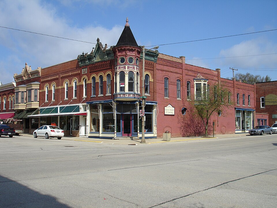
Photograph of W.E. White Building
Photograph by IvoShandor, CC BY-SA 3.0. Via Wikimedia Commons.

W.E. White Building

Listed on the National Register of Historic Places in 1997.

From the record

“White Building is a historic commercial building located in downtown Stockton, Illinois, United States. It was constructed in the Queen Anne style in 1897 and designed and built by Peter Schroeder.”

Wikipedia article W.E. White Building, CC BY-SA 4.0.

One of 17 National Register listings published here for Jo Daviess County · listed in 1997 · category: Building.

Sources: the Wikipedia article · the case file at the National Archives · the National Register database, National Park Service

The listing

  • What is counted as historic. The nomination lists 1 building as contributing to the listing.
  • Listed as. White, W.E., Building - the National Register files a house under its owner's surname.
  • Address. 100 N. Main St., Stockton, 61085
  • When was it listed? November 1997
  • Category. building
  • Township. Stockton township
  • Architectural style. Queen Anne style architecture in the United States
  • National Register reference number. 97001339 - the number the National Park Service assigned this property when it was listed, and the key its nomination file is catalogued under at the National Archives.

The ground it stands on

5,386 words

The chapter on Stockton Township in The History of Jo Daviess County, Illinois, Containing a History of the County, Its Cities, Towns, Etc., a Biographical Directory of Its Citizens, War Record of Its Volunteers in the Late Rebellion ... History of the Northwest, History of Illinois ... Constitution of the United States, published 1878 names Stockton. This is what it says, exactly as the scans read.

This name was suggested by Alanson Parker, who desired it named after a town in the East, and, also, as suggestive of the future development of the township, as one devoted to the raising of stock. The prophetic eye which foresaw this, was not in error, for to-day the farmers of this township are nearly all exclusive stock-raisers, and the beautiful prairies through it are devoted to pasturage or meadows ; and stacks of hay are far more numerous than piles of straw, while the stubble is that of grass and corn, rather than of oats and wheat. The first settler of the township was Henry Rice, who moved from Galena to Section 3 in 1832 with Philip Rice and others, who have been referred to more at length in the history of Rush Township. John Hayes moved to this township in 1836, from Indiana, where soon after his little daughter died - this being doubtless the first death of a white person in Stockton Township. Discouraged by the hardships of Western life, Mr. Hayes sold his claim and cabin, in 1837, to Elisha C. Hamilton, and returned to Indiana. Mr. Hamilton continued to live there until the time of his death, gaining a large circle of friends and being elected the first Supervisor of his township.

Passage source: The History of Jo Daviess County, Illinois, Containing a History of the County, Its Cities, Towns, Etc., a Biographical Directory of Its Citizens, War Record of Its Volunteers in the Late Rebellion ... History of the Northwest, History of Illinois ... Constitution of the United States, published 1878.

The first school records were made in 1843, when E. C. Hamilton, J. R. Patridge and B. F. Parker were appointed trustees by the Commissioners Court. An enumeration of school children was made that year and it was found that there were seventy-five in the township. In 1868 there were 670, and at the present time there are 559. In 1843 the township was divided into two districts; now there are eight school-houses and a number of joint districts with other townships. The early history of Stockton and Ward's Grove Townships is intimately connected, and many men who are now residents of Stockton Township, came to Ward's Grove as early as 1835 to '38. The Tyrrells came in 1838; Miles and Frank are now living in Stockton Township. James Blair was also an early settler of Ward's Grove, although now living in Stockton. The vicinity of Morseville has been a trading point for a great many years ; a blacksmith shop in 1851 by Jonathan Parker, and store, was one of the early institutions. In 1852, Miles Tyrrell purchased the business of Talbot, and has since been continually connected with the business interests of the place. In 1866, Ashael Morse had the Village of Morseville platted and recorded. In 1871 he built his hotel there, and, during the same year, the greater part of the buildings in the village were erected. In an early day the people were poorly provided with post-offices, although the township now has five. There was a post-office in the south part of the township known as West Plum River, but that was abandoned in 1842. Another office was established at or ne'ar the same place about 1849. During Buchanan's administration it was removed to Morseville, and Miles Tyrrell made postmaster. R. Strickland at present manages the office. In the Spring of 1862 another office was established, known as Yankee Hollow, and G. L. Dow made postmaster. He held the office until 1865, when B. F. Parker took it and held it until his death in 1874. His daughter was commissioned in Feb., 1875, and now holds the office. At quite an early day an office was established near the centre of the township known as Stockton, and Fred. Tucker was made postmaster. He went to California several years ago, when his wife took charge of the office, and continued to discharge the duties until May, 1875, when it was removed to Geo. Justus', and he was made postmaster. A post-office called Pitcherville was established in the northeast part of the township in 1868, and Mr. Pitcher officiated as postmaster. S. T. Eade now has charge of the office. In 1874 an office named Winters was established near the centre, with Henry Winter as postmaster. He still acts in that capacity. There are two church buildings in the township ; one at the centre, and one at Morseville. The centre church nominally belongs to the Free Will Baptists, but the organization is very weak, and maintains no regular services. It was built in 1868. The church at Morseville is a Union church which was erected in 1870, and any denomination is welcome to the use of it. The Winebrenarians have a feeble organization, but do not hold regular services.

Passage source: The History of Jo Daviess County, Illinois, Containing a History of the County, Its Cities, Towns, Etc., a Biographical Directory of Its Citizens, War Record of Its Volunteers in the Late Rebellion ... History of the Northwest, History of Illinois ... Constitution of the United States, published 1878.

Machine-read from a century-old scan, so expect the errors a machine makes: misspelled names, dropped words, stray characters.

Read the whole chapter on Stockton Township - 5,386 words on its settlement, mills, schools and churches.

Fires near this property

1 since 2004

Regional context, not property-specific evidence. The federal wildfire occurrence database lists 1 fire within 5 miles of W.E. White Building in 2004, burning about 2 acres in total. None started naturally. None was recorded as arson. Distance is straight-line from the map coordinates, so a fire counted here may appear on a neighbouring settlement's page as well.

Reported cause Fires
Recreation and ceremony1

The most recent of them, most recent first, with the day each was reported and the service that recorded it.

DateCause SizeReported by Name on the report
17 April 2004Recreation and ceremony2.0 acresIllinois State Fire Marshal's Officenot named

Every fire recorded in Jo Daviess County

Mines and quarries near this property

6 within 5 miles

Regional context, not property-specific evidence. The federal mineral resources record lists 6 workings within 5 miles of W.E. White Building: 5 past producers, 1 producer. 1 still produces. What was taken out: Stone, Crushed/Broken, Limestone, General. Distance is straight-line from the map coordinates, so a quarry counted here may appear on a neighbouring settlement's page as well.

Where SiteCommodity StatusRecorded
Piierce QuarryLimestone, GeneralPast Producer
Anderson QuarryStone, Crushed/BrokenPast Producer
Lena PitStone, Crushed/BrokenProducer
Millershane QuarryStone, Crushed/BrokenPast Producer
Townsend QuarryStone, Crushed/BrokenPast Producer
Westaby QuarryStone, Crushed/BrokenPast Producer

Every working recorded in Jo Daviess County

Storms near this property

60 of 73 shown

Regional context, not property-specific evidence. The National Weather Service names Stockton, the town this property stands in, in 73 storm reports between 1993 and 2026: 42 thunderstorm wind, 16 hail, 7 flash flood, 5 heavy rain. The reports record 1 injury. Each account below is quoted exactly as the forecast office filed it, from the NOAA Storm Events Database, and each date opens the federal record of that event.

WhenEvent Place namedHarm What the report says
February 1999Thunderstorm WindStockton1 hurtno account filed
June 2011Thunderstorm WindStockton$50,000Wind gusts estimated to be 70 mph caused tree damage and siding damage across Stockton, IL around 930 pm CDT June 8. One large tree limb fell onto a car.
July 2003Thunderstorm WindStockton$50,000Trees & power lines down
July 2017Flash FloodStockton$40,000A trained spotter reported widespread flooding in the town of Stockton. Rainfall totals reached 7.81 inches in 6 hours.
August 2008Thunderstorm WindStockton$25,000Wind gusts estimated to be 70 mph blew a tree onto a house in Stockton, IL at 610 pm August 4.
June 2004Flash FloodStockton$10,000U.S. 20 impassable
August 2003LightningStockton$7,500Location is 0.5 to 1.5 miles west of Loran, Illinois in Stephenson County. The barn was in poor condition and was used to house only cattle and hay. All the cattle were successfully evacuated from the barn and the hay was very old and in poor quality.
June 2005Thunderstorm WindStockton$5,000Power out.
August 2003Thunderstorm WindStockton$5,000Measured gust by Co-op
June 2006Thunderstorm WindStockton$2,000trees and power lines down
July 2011Thunderstorm WindStockton$1,000Wind gusts estimated to be 65 mph blew some storm windows into a home in Stockton, IL at 627 am CDT July 11. Some metal yard furniture was also blown around the yard. This report was relayed by WREX.
March 2005Thunderstorm WindStockton$500Reported by Co-op.
August 2008Thunderstorm WindStockton$200Wind gusts estimated to be 65 mph blew down some five inch diameter tree branches and bent a metal pole supporting a wind sock in half in Stockton, IL at 628 pm August 4. A metal table was also blown off of a deck.
March 2026HailStockton-The COOP Observer reported that the hail lasted for 3 minutes.
April 2026Thunderstorm WindStockton-Recorded with an anemometer.
April 2026Thunderstorm WindStockton-Power poles blown down just south of Stockton Illinois. This was determined to be done by straight line winds.
April 2026Thunderstorm WindStockton-A 3 foot diameter tree blown down.
April 2026HailStockton-Photos on social media.
May 2024Thunderstorm WindStockton-Several large trees damaged. Time estimated from radar data.
July 2024Thunderstorm WindStockton-The COOP observed report tat several trees were down of various diameter. One was a foot in diameter.
July 2024Thunderstorm WindStockton-The COOP Observer reported a measured 84 MPH gust on a personal home weather station.
November 2022Thunderstorm WindStockton-A COOP Observer reported a very strong wind gusts measured on a wind sensor 24 feet above the ground. There were many branches down.
July 2022Flash FloodStockton-The COOP Observer reported patio flooded with water flowing through the basement window. Measured 3.05 inches of rain between 9 and 11 PM.
October 2021Thunderstorm WindStockton-A trained spotter reported a brief strong wind gust from there personal weather station.
October 2021Thunderstorm WindStockton-A trained spotter reported a measured wind gust of 60 knots.
August 2020Thunderstorm WindStockton-A power pole and wires were blown down in Stockton, Illinois.
June 2019Thunderstorm WindStockton-A public report via social media of a shed flipped and destroyed on Simmons Steet. The time of the event was estimated using radar.
September 2019Thunderstorm WindStockton-Electric and phone wires blown down on the southeast side of Stockton Illinois. The report was relayed by the 911 call center.
October 2018Flash FloodStockton-Law enforcement reported water over the road from creek flooding at the intersection of Howardsville Road and Mammoser Road.
July 2017Flash FloodStockton-The Illinois Department of Highways reported Highway 20 east of Stockton was closed due to high water.
March 2017Thunderstorm WindStockton-A large tree was down on a power line in Stockton resulting in a power outage for the local area.
June 2017Thunderstorm WindStockton-Tree branches and power poles were blown down.
July 2016Thunderstorm WindStockton-Local law enforcement reported trees and power lines were down. The time was estimated by radar.
June 2014Thunderstorm WindStockton-Wind measured on wind equipment.
June 2014Thunderstorm WindStockton-Measured on home weather station.
June 2014Thunderstorm WindStockton-A large grain bin was blown onto Willow Road near Stockton.
June 2014Thunderstorm WindStockton-The emergency manager reported widespread wind damage with Highway 20 closed from Stockton east into Stephenson county. Several other highways were closed due to trees blocking the roads.
May 2013Thunderstorm WindStockton-A COOP observer measured 65 mph winds.
May 2013Thunderstorm WindStockton-A COOP observer measured a 4 inch diameter tree limb down at the residence.
July 2012Thunderstorm WindStockton-A COOP observer measured a 58 mph wind gust. He also reported an 8 inch diameter main tree branch broken off near Stockton and several small 1 inch diameter branches down.
July 2011Heavy RainStockton-As of 850 pm CDT July 27, the rainfall total in Stockton, IL was 3.00 inches and it was still raining.
July 2011Tornado (EF0)Stockton-Around 755 pm CDT July 27, a tornado was reported about 3 miles northeast of Stockton, IL near Tiger Whip Road. This report was relayed by the emergency manager.
July 2011Heavy RainStockton-As of 1230 am CDT July 28, the 5 1/2 hour rainfall total in Stockton, IL was 4.95 inches.
August 2011Heavy RainStockton-The rain fell over a period of 25 minutes.
September 2010HailStockton-Half dollar-sized hail fell in Stockton, IL at 327 pm CDT September 21.
June 2010Flash FloodStockton-Heavy rains of 1.5 inches in 30 minutes resulted in flash flooding in Stockton, IL during the afternoon of June 15. This report was relayed by WREX TV.
July 2009HailStockton-Tennis ball-sized hail fell 2 miles north of Stockton, IL around 558 pm July 24.
July 2009HailStockton-Golf ball-sized hail fell about 4 miles east northeast of Stockton, IL around 604 pm July 24.
July 2009HailStockton-Golf ball-sized hail fell for a few minutes in Stockton, IL around 605 pm July 24.
July 2009HailStockton-Hail up to 2 inches in diameter fell in Stockton, IL around 607 pm July 24.
July 2009Thunderstorm WindStockton-Wind gusts were estimated to be 50 to 60 mph about 3 miles northwest of Stockton, IL at 855 pm July 27.
June 2008HailStockton-Penny-sized hail fell in Stockton, IL at 7:52 pm June 8. The hail stones broke into slivers and chunks upon hitting the ground.
May 2008HailStockton-Golf ball-sized hail fell in Stockton, IL around 9:45 pm. This report was relayed by a trained spotter.
June 2008HailStockton-Quarter-sized hail fell in Stockton, IL at 8:55 am June 8.
June 2006Thunderstorm WindStockton-measured gust
September 2006Heavy RainStockton-The co-op observer reported 1.25 inches of rain in the past hour.
May 2004Thunderstorm WindStockton-From Co-op observer.
June 2004Heavy RainStockton-In the past 2 hours.
July 2004Thunderstorm WindStockton-From co-op observer.

Every storm recorded in Jo Daviess County

Map coverage status

No historic map-sheet match is published for this property yet. That does not mean no map exists. This record needs a coordinate-quality review before it can be joined to a sheet boundary. Browse the county's mapped places while that work is pending.

Listed places nearby

2 within 8 miles

Other National Register properties close enough to walk or drive between, ordered by distance from this one. Both positions come from the same geocoding pass that matched these properties to their map sheets.

Photograph PropertyDistance Listed
Townsend House2.8 miles2005
Millville Town Site6.7 miles2003

Sources for this property

National Archives recordThe nomination case file for reference 97001339 in Record Group 79.
Wikipedia articleCommunity-written account of this property, licensed CC BY-SA.
Jo Daviess CountyAll 17 listed properties in this county.

Provenance

  • Listing record. National Park Service National Register of Historic Places, listed-properties dataset, current to 2026-05-22.
  • Map join. Address geocoded through the United States Census geocoder, then tested against the published boundary of every sheet in the USGS Historical Topographic Map Collection.
  • How this page is made. Listing fields come from federal records; map-sheet coverage is a labelled coordinate-to-boundary calculation, not a source-field claim.
  • Wildfire. Short, Karen C. 2022. Spatial wildfire occurrence data for the United States, 1992-2020 [FPA_FOD_20221014]. 6th Edition. Fort Collins, CO: Forest Service Research Data Archive. https://doi.org/10.2737/RDS-2013-0009.6 Collected with United States Government funding and usable without additional permissions or fees.
  • Mines and quarries. USGS Mineral Resources Data System (MRDS) https://mrdata.usgs.gov/mrds/ A work of the United States government, no copyright under 17 U.S.C. 105.
  • Storms. NOAA National Centers for Environmental Information, Storm Events Database https://www.ncei.noaa.gov/stormevents/ A work of the United States government, no copyright under 17 U.S.C. 105. Narratives are quoted verbatim from the National Weather Service report and are not edited or summarised.