BlockBefore
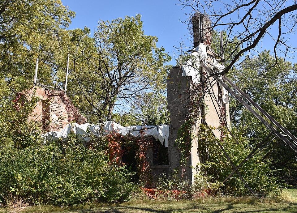
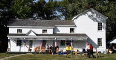
Photograph of Brunk Farmstead
Photograph by Boscophotos, CC BY-SA 3.0. Via Wikimedia Commons.

Brunk Farmstead

Listed on the National Register of Historic Places in 1999.

From the record

“The Brunk Farmstead is a historic farm located on KOA Campground Road 1 mile (1.6 km) south of East Lake Drive near Rochester, Illinois. George Brunk, an early settler of Sangamon County, established the farm in the 1820s; the farm is one of the few surviving properties from the county's early settlement.”

Wikipedia article Brunk Farmstead, CC BY-SA 4.0.

One of 68 National Register listings published here for Sangamon County · listed in 1999 · category: Building.

Sources: the Wikipedia article · the case file at the National Archives · the National Register database, National Park Service
The listing

  • What is counted as historic. The nomination lists 2 buildingss as contributing to the listing.
  • Address. KOA Campground Rd., i mi. S. of E. Lake Dr., Rochester, 62563
  • When was it listed? December 1999
  • Category. building
  • Township. Cotton Hill township
  • National Register reference number. 99001569 - the number the National Park Service assigned this property when it was listed, and the key its nomination file is catalogued under at the National Archives.

The ground it stands on

8,178 words

The chapter on Cotton Hill Township in History of Sangamon County, Illinois; Together with Sketches of Its Cities, Villages and Townships ... Portraits of Prominent Persons, and Biographies of Representative Citizens. History of Illinois, published 1881 names Rochester. This is what it says, exactly as the scans read.

The township of Cotton Hill lies in the southeastern part of the county, and is bounded on the east by Cooper township and Christian county; west, by Ball township; north, by Rochester, and south, by Pawnee township and Christian county. The soil is of good quality, and the township is well watered by Horse creek and the south fork of the Sangamon river, and Brush creek, and numerous springs. Horse creek enters the township on section thirty-one, and running in a northerly course, passes out from section six. The Sangamon river enters on section twelve, and by a meandering course, passing through sections twelve, eleven, two, three and four, into Rochester township. Horse creek waters the western half, from south to north, and enters Rochester between sections five and six.

Passage source: History of Sangamon County, Illinois; Together with Sketches of Its Cities, Villages and Townships ... Portraits of Prominent Persons, and Biographies of Representative Citizens. History of Illinois, published 1881.

William Baker was born about lv98, in Sevier county, Tennessee. He came to St. Clair county, Illinois, when a young man. Phoebe Neeley was born December 14, 1799, near Nashville, Tennessee, and was taken to St. Clair county, Illinois, when she was a young woman. Williarh Baker and Phoebe Neeley were married about 1818, near Belleville. They had one child born there, and the family moved to Horse creek, in what became Sangamon county, in the spring of 1819, in what is now Cotton Hill township, where seven children were born. They then moved to a mill on the north fork of the Sangamon river, three miles north of Rochester. William Baker went to Texas previous to 1844, started from there to California about 1852, and died on the road. Mrs. Phoebe Baker died, August, 1861, in Rochester.

Passage source: History of Sangamon County, Illinois; Together with Sketches of Its Cities, Villages and Townships ... Portraits of Prominent Persons, and Biographies of Representative Citizens. History of Illinois, published 1881.

Machine-read from a century-old scan, so expect the errors a machine makes: misspelled names, dropped words, stray characters.

Read the whole chapter on Cotton Hill Township - 8,178 words on its settlement, mills, schools and churches.

Mines and quarries near this property

1 within 5 miles

Regional context, not property-specific evidence. The federal mineral resources record lists 1 working within 5 miles of Brunk Farmstead: 1 past producer. None of them still produces. What was taken out: Fire Clay (Refractory). Distance is straight-line from the map coordinates, so a quarry counted here may appear on a neighbouring settlement's page as well.

Where SiteCommodity StatusRecorded
Springfield Clay Prod.Co.PitclayFire Clay (Refractory)Past Producer

Every working recorded in Sangamon County

Storms near this property

7 since 2013

Regional context, not property-specific evidence. The National Weather Service names Rochester, the town this property stands in, in 7 storm reports between 2013 and 2023: 6 thunderstorm wind, 1 hail. No death or injury is recorded in these reports. Each account below is quoted exactly as the forecast office filed it, from the NOAA Storm Events Database, and each date opens the federal record of that event.

WhenEvent Place namedHarm What the report says
June 2019Thunderstorm WindRochester$80,000Multiple trees and power lines were blown down throughout Rochester. One tree fell onto a house and car.
April 2013Thunderstorm WindRochester$7,000A fruit tree was snapped in half. A large fence was blown down and a few shingles were ripped from a roof.
June 2023Thunderstorm WindRochester-Several large tree branches were blown down.
May 2019Thunderstorm WindRochester-A tree limb was blown onto a power line.
July 2017Thunderstorm WindRochester-A 4-inch diameter tree branch was blown down.
June 2015Thunderstorm WindRochester-Two power poles were blown down on Buckhart Road just east of Rochester.
March 2020HailRochester-no account filed

Every storm recorded in Sangamon County

Map coverage status

No historic map-sheet match is published for this property yet. That does not mean no map exists. This record needs a coordinate-quality review before it can be joined to a sheet boundary. Browse the county's mapped places while that work is pending.

Listed places nearby

6 within 8 miles

Other National Register properties close enough to walk or drive between, ordered by distance from this one. Both positions come from the same geocoding pass that matched these properties to their map sheets.

Photograph PropertyDistance Listed
Abraham Lincoln Memorial Garden0.7 miles1992
Route 66 South of Lake Springfield2.0 miles2009
Strawbridge-Shepherd House2.3 miles2015
Route 66 South of Lake Springfield2.6 miles2009
Taft Farmstead4.1 miles1980
Sugar Creek Covered Bridge5.6 miles1978

Sources for this property

National Archives recordThe nomination case file for reference 99001569 in Record Group 79.
Wikipedia articleCommunity-written account of this property, licensed CC BY-SA.
Sangamon CountyAll 68 listed properties in this county.

Provenance

  • Listing record. National Park Service National Register of Historic Places, listed-properties dataset, current to 2026-05-22.
  • Map join. Address geocoded through the United States Census geocoder, then tested against the published boundary of every sheet in the USGS Historical Topographic Map Collection.
  • How this page is made. Listing fields come from federal records; map-sheet coverage is a labelled coordinate-to-boundary calculation, not a source-field claim.
  • Mines and quarries. USGS Mineral Resources Data System (MRDS) https://mrdata.usgs.gov/mrds/ A work of the United States government, no copyright under 17 U.S.C. 105.
  • Storms. NOAA National Centers for Environmental Information, Storm Events Database https://www.ncei.noaa.gov/stormevents/ A work of the United States government, no copyright under 17 U.S.C. 105. Narratives are quoted verbatim from the National Weather Service report and are not edited or summarised.