BlockBefore
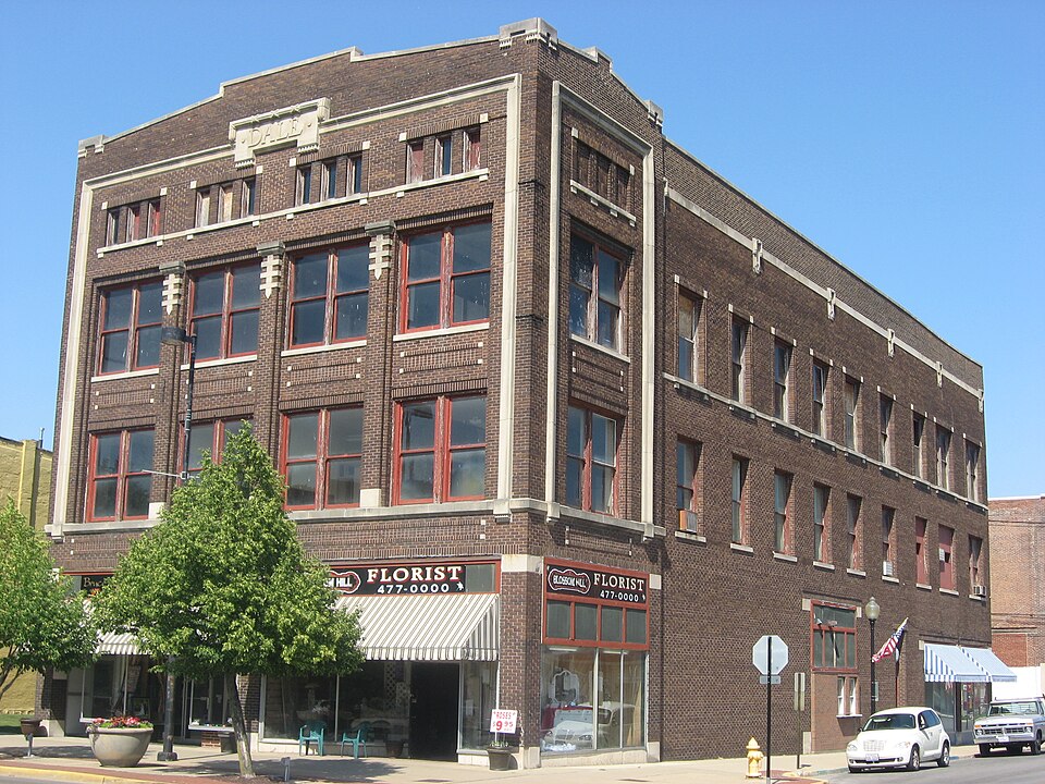
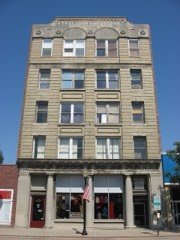
Photograph of Dale Building
Photograph by Nyttend, Public domain. Via Wikimedia Commons.

Dale Building

Listed on the National Register of Historic Places in 2000.

From the record

“The Dale Building is a historic commercial office building located at 101-103 North Vermilion Street in Danville, Illinois.”

Wikipedia article Dale Building, CC BY-SA 4.0.

One of 13 National Register listings published here for Vermilion County · listed in 2000 · category: Building.

Sources: the Wikipedia article · the case file at the National Archives · the National Register database, National Park Service

The listing

  • What is counted as historic. The nomination lists 1 building as contributing to the listing.
  • Address. 101-1-3 N. Vermillion St., Danville, 61832
  • When was it listed? January 2000
  • Category. building
  • Township. Newell township
  • National Register reference number. 99001711 - the number the National Park Service assigned this property when it was listed, and the key its nomination file is catalogued under at the National Archives.

The ground it stands on

21,866 words

The chapter on Newell Township in History of Vermilion County, Together with Historic Notes on the Northwest, Gleaned from Early Authors, Old Maps and Manuscripts, Private and Official Correspondence, and Other Authentic, Though, for the Most Part, Out-of-the-way Sources, published 1879 names Danville. This is what it says, exactly as the scans read.

The pioneers were early attracted to this section of country. Its rich soil, pure water, abundant timber, and picturesque configuration, afforded strong inducements to them to accept with cheerfulness the deprivations of the border. The earlier settlers came mostly from Ohio and Kentucky. In those theaters of stirring experience they had been trained to vigorous exercise and ingenious resource. Their capital - steady and industrious habits, strong wills and constitutions - was the best for the times and the circumstances; with little else, they came to build homes and to gather around them the ordinary conveniences of civilized life. To leave comfortable firesides and happy associations and emigrate to this wild region, was no trifling episode in their lives. It was not unmixed with trials and difficulties, which abounded with disheartening constancy. The splendor and mazy activities of the present day so monopolize our interest that we cannot content ourselves, while looking back, to dwell on the picture long enough to get a distinct view of objects. The failure, therefore, nigh universal, to comprehend and appreciate the personal sacrifices of these resolute men and women, is not surprising. But the fact, however, is the same - that they laid the foundations of the local inheritance and prosperity of this generation. To the Le Neves must be accorded the honor of making the first beginning in Newell township. In the fall of 1823, Obadiah Le Neve journeyed on horse-back from Vincennes to St. Louis, and thence into Northeast Missouri, and on his homeward trip made a circuit in northern Illinois. With very correct judgment he pronounced the region enclosed in the present limits of Newell township the best that he had seen. Obtaining the numbers of the following tracts - W. \ N.W. \ Sec. 23, and E. \ N.E. \ Sec. 24, town 20 N., range 11 W., 3d principal meridian - he returned home, and a public land sale shortly after occurring, he purchased those pieces. Just prior to Christmas, in the year 1824, Obadiah and John Le Neve left their relations in Lawrence (then Crawford) county, Illinois, and with a team loaded with provisions and a small outfit of bedding, they set out for their future home. A third person accompanied to take the team back. On arriving at their destination, they rived a few rails and laid up a square, chinking and filling the interstices with pulled grass, and covering one half of the rude structure with puncheons. The Indians were numerous, and came to their camp with freedom, and behaved in the most friendly manner. They never disturbed anything while the men were away, though they often came about the place during their absence. They proved themselves honest and conscionable neighbors. When the pioneers spread their homely meals, the Indians, if any were present, were invited to the repast, and they always accepted with the best familiarity which hunger and gratitude could prompt. The immigrants had other neighbors far less companionable. These were the wolves that came about in great numbers, making the woods resonant with their hideous nocturnal serenade. The two brothers had come to prepare for their ultimate removal, and during the whole winter, which they spent in this neighborhood, were splitting rails. Toward the latter part of February they began to prepare for their departure. They first erected a cabin on section 14, town 20, about forty rods west of where John Le Neve has always lived. This was for occupation by Ben. Buttertield, who was expected to arrive soon with his family. He came near the close of the month, and two or three days later the Le Neves went back. The actual settlement of Newell township was thus begun by Buttertield, in February, 1825. In the course of the summer and fall quite numerous additions were made to the number of inhabitants, as the following list will show: John Current arrived from Virginia. The Howards - Henry, Lackland, Amos, Aaron and Nathan - and William and James Delay emigrated from Ohio. Jeremiah Delay, son of James Delay, probably came at the same time. Oliver Miller settled on Stony Creek in section 14. The Le Neves returned in November or December. Samuel and John Adams and Joseph Martin came together, from Harrison county, Kentucky. The first located on section 22, town 20, where he has always resided. William Newell, from the same place, settled on section 23, just east of Adams. John Lamb and his son Simeon (Quakers), natives of North Carolina, came from Indiana. John Goodener, Elijah Hale and John Swisher settled in the timber between Samuel Adams' and Solomon Rodrick's. Three brothers of John Swisher - Samuel, Lewis and Jacob - also lived in the same neighborhood, but the date of their settlement cannot be given. All these persons were from Ohio. George Ware came to Vermilion county this year. He made a farm on section 16 in this township. The next year Adam Starr came up from Georgetown. Samuel Swinford, Richard Blair, William Adams, Edward Martin and James Newell came from Harrison county, Kentucky. The last came the year before to examine the country, and entered land on section 10, on the 5th day of October. Abraham and Frederick Stipp, from Virginia, settled on section 9. John Watson settled in the south part of the township. In 1827 William Current, from Virginia, settled on section 36, town 20. David Tickle, Jacob and George Swisher, and Eli Hewitt, came from Ken- tucky. Nathaniel Taylor settled in the Le Neve neighborhood, and afterward went to Denmark. Joseph Gundy began improvements near Myersville, but did not bring his family until the next year. Luke Wiles, from Indiana, settled across the Fork from Myersville. In 1828 Hugh Bolton and Solomon Rodrick emigrated from Ohio. The latter settled where he now lives, on section 34, town 20. Dr. John Woods, a native of New York, located in the southeast part of the township as early as this year. It is believed that his father-in-law, Supply Butterfield, came not far from this time. Those from Kentucky were Thomas Hendren, Jehu Chandler, Jacob Eckler, James Duncan and his sons Asa, Alpha, Darius and James. In 1829 Ralph Martin and his step-son John P. Lindsey, Henry Ferguerson, William Cunningham and his minor sons James and Joseph, Harrison Oliver, George W. Smith, Samuel Oliver and his son Bushrod, John Shafer, and James and Andrew Makemson. arrived from Kentucky. Ambrose Andrews and his family, including his son Ambrose Phelps, just then of age, Nathaniel Glaze and family, Thomas Carter and family, Jacob Bumgardner, William Longshore, Robert Thornsburg, and John Stalcup, came together. Abram and Josiah Henkle, Henry Wood, Peter Starr, a native of North Carolina, William G. Blair, a native of Kentucky, Andrew Davison and his sons James and Robert, Virginians, all came from Ohio. Samuel Torrence came this year or earlier. In 1830, George Stipp, Robert Price, Richard Brewer, William J. Barger, and Consider Scott, a native of New York, came from Ohio. Valentine Leonard and his sons-in-law, Charles S. Young, John Young and Otho Allison, emigrated from Kentucky. The next year Caleb Worley arrived from Kentucky, and George French from Indiana. Louis Neely came in 1832; also Daniel P. Huffman came from Kentucky. John Campbell, and Samuel Campbell, jr., migrated from New York in 1833. In the following year Harper J. and Joseph Campbell, brothers to these, and Samuel Campbell, sr., located in this township. Clarendon E. Loring, a native of Maine, came from Indiana. Zachariah Robertson, Jacob Huffman, John Deck and John Rutledge, arrived from Kentucky. Michael Deck probably came at the same time. Jacob Deck, a Pennsylvanian, settled here in 1835. John Stipp, a brother to those who had already located in the township, and John Williams, recently from England, came about this time. The following is a list of early settlers who came perhaps not later than 1835: Armenus Miller, Michael and James Leonard, Edward Morgan, Samuel Briarly, Isaiah Treat, William Stevens, a preacher, Robert Layton, from Kentucky, Abel and Vatchel Newborough, Duncan Lindsey, a man named Long, and another named Moss. The latter built a tannery on section 26, town 20, but in 1834 sold his place to Samuel Campbell, sr., and settled in Danville township, where he built another tannery.

Passage source: History of Vermilion County, Together with Historic Notes on the Northwest, Gleaned from Early Authors, Old Maps and Manuscripts, Private and Official Correspondence, and Other Authentic, Though, for the Most Part, Out-of-the-way Sources, published 1879.

This ancient town, situated on the left bank of the North Fork, two miles above Danville, was settled by Seymour Treat, probably in 1826. In "Coffeen's Hand-Book of Vermilion County" we find this information : "The first settler within the present limits of this county was Seymour Treat, in 1819, or perhaps in 1820. He came with a man by the name of Blackburn, to the salt springs, on Salt Fork, for the purpose of manufacturing salt. He afterward settled Denmark and built a saw-mill at that place." Treat's mill was a "corn cracker" and sawmill combined. He was the first blacksmith in Newell township, and besides operating his mill, worked some at his trade.

Passage source: History of Vermilion County, Together with Historic Notes on the Northwest, Gleaned from Early Authors, Old Maps and Manuscripts, Private and Official Correspondence, and Other Authentic, Though, for the Most Part, Out-of-the-way Sources, published 1879.

Machine-read from a century-old scan, so expect the errors a machine makes: misspelled names, dropped words, stray characters.

Read the whole chapter on Newell Township - 21,866 words on its settlement, mills, schools and churches.

Fires near this property

6 since 2004

Regional context, not property-specific evidence. The federal wildfire occurrence database lists 6 fires within 5 miles of Dale Building between 2004 and 2014, burning about 20 acres in total. None started naturally. None was recorded as arson. Distance is straight-line from the map coordinates, so a fire counted here may appear on a neighbouring settlement's page as well.

Reported cause Fires
Debris and open burning2
Missing data/not specified/undetermined2
Smoking1
Equipment and vehicle use1

The most recent of them, most recent first, with the day each was reported and the service that recorded it.

DateCause SizeReported by Name on the report
23 September 2011Missing data/not specified/undetermined10 acresIllinois Division of Forestry ResourcesDANVILLE
19 April 2004Missing data/not specified/undetermined4.0 acresIllinois State Fire Marshal's Officenot named
23 March 2004Smokingunder an acreIllinois State Fire Marshal's Officenot named
17 March 2014Debris and open burning3.0 acresIllinois Division of Forestry ResourcesHOLLOWRD92
29 December 2013Debris and open burningunder an acreIllinois Division of Forestry ResourcesJORDAN1
8 October 2010Equipment and vehicle use1.5 acresIllinois Division of Forestry ResourcesHUGHES

Every fire recorded in Vermilion County

Mines and quarries near this property

6 within 5 miles

Regional context, not property-specific evidence. The federal mineral resources record lists 6 workings within 5 miles of Dale Building: 3 past producers, 2 occurrences, 1 producer. 1 still produces. What was taken out: Sand and Gravel, Construction, Fire Clay (Refractory), Clay. Distance is straight-line from the map coordinates, so a quarry counted here may appear on a neighbouring settlement's page as well.

Where SiteCommodity StatusRecorded
Danville PitClayPast Producer
Harmattan Mine Shale ExposureFire Clay (Refractory)Occurrence
Western Brick Co. Shale ExposureFire Clay (Refractory)Occurrence
Sand Valley Sand & GravelSand and Gravel, ConstructionProducer
Thomas PitSand and Gravel, ConstructionPast Producer
Tucker PitSand and Gravel, ConstructionPast Producer

Every working recorded in Vermilion County

Storms near this property

60 of 95 shown

Regional context, not property-specific evidence. The National Weather Service names Danville, the town this property stands in, in 95 storm reports between 1994 and 2024: 67 thunderstorm wind, 24 hail, 3 flash flood, 1 lightning. No death or injury is recorded in these reports. Each account below is quoted exactly as the forecast office filed it, from the NOAA Storm Events Database, and each date opens the federal record of that event.

WhenEvent Place namedHarm What the report says
May 1998Thunderstorm WindDanville$350,000A severe thunderstorm moved south across Vermilion County. It caused considerable damage to the roof of a canning factory in Danville, as well as, destroying a nearby gas station's sign and causing minor damage to a hotel roof. As the storm moved into Georgetown, it blew down several large tree limbs and power lines. No injuries were reported. Damage to the canning factory was estimated around $350,000.
August 2020Thunderstorm WindDanville$100,000Numerous trees and power lines were blown down throughout Danville. Several streets were blocked.
March 2017Thunderstorm WindDanville$80,000Numerous trees and power lines were blown down in Danville.
June 2015Thunderstorm WindDanville$80,000Numerous trees were blown down in Danville causing power outages across the city.
April 2020Thunderstorm WindDanville$70,000Roof damage to buildings on Bensyl and Emerson and the 100 block of North Walnut.
November 2016Thunderstorm WindDanville$70,000Numerous power lines were blown down in Danville.
November 2013Thunderstorm WindDanville$60,000A roof was blown off a house.
June 2015Thunderstorm WindDanville$50,000A 30x50 farm building was destroyed by strong thunderstorm winds.
August 2013Thunderstorm WindDanville$50,000Several trees were blown down in Danville. Approximately 200 people lost power as 50 to 60 mph winds arrived along a gust front.
July 2017Thunderstorm WindDanville$40,000Several trees were snapped or uprooted across Danville.
May 2013Thunderstorm WindDanville$40,000Numerous power lines were blown down around Danville.
May 2011Thunderstorm WindDanville$40,000Several trees and powerlines were blown down near Danville.
May 2011Thunderstorm WindDanville$40,000Numerous powerlines were blown down on the east side of Danville.
June 2016Thunderstorm WindDanville$35,000Several trees were blown down in Danville, including one that fell on a parked car.
June 2011Thunderstorm WindDanville$35,000Several trees were blown down in Danville. In addition, a power pole was knocked down at the intersection of 3rd St. and Highland Blvd.
June 2009Thunderstorm WindDanville$35,000Numerous trees and power lines were blown down. A house was damaged by a falling tree.
July 2013Thunderstorm WindDanville$30,000Numerous trees and tree branches were blown down across Danville.
August 2010Thunderstorm WindDanville$30,000Numerous trees and power lines were blown down on the north side of Danville.
June 2008Thunderstorm WindDanville$30,000Numerous trees down on the south and east side of Danville.
June 2010Thunderstorm WindDanville$25,000Numerous power lines were blown down.
September 2015Thunderstorm WindDanville$20,000Numerous large tree branches were blown down across Danville.
June 2011Thunderstorm WindDanville$20,000Numerous trees were blown down along Grape Creek Road south of Danville.
August 2008Thunderstorm WindDanville$20,000Numerous trees were blown down in Danville.
March 2017Thunderstorm WindDanville$15,000Numerous small trees and tree limbs were blown down. Railroad crossing gates were blown off and broken as well.
June 2013Thunderstorm WindDanville$15,000A 2-foot diameter tree was blown down onto a car in Danville.
July 2008Thunderstorm WindDanville$15,000Power lines were blown down on the southeast side of Danville.
March 2017Thunderstorm WindDanville$14,000Two power poles were blown down.
June 2011Thunderstorm WindDanville$10,000Power lines were blown down on Gilbert Street in Danville.
June 2013Thunderstorm WindDanville$8,000A tree and power lines were blown down at Bowman and Seminary Streets in Danville.
May 2008Thunderstorm WindDanville$5,000A large tree was blown down onto power lines.
July 2012Thunderstorm WindDanville$3,000A large tree was blown down near the intersection of 1750E and 2000N.
May 2015Thunderstorm WindDanville$2,000A tree and a large tree limb were blown down.
July 2015Thunderstorm WindDanville$2,000A tree was blown down across the railroad tracks at 3rd Street in Danville.
March 2012LightningDanville$2,000Lightning struck a power pole, knocking down power lines across a road in Danville.
June 2010Thunderstorm WindDanville$2,000A large tree was blown down.
July 2008Thunderstorm WindDanville$2,000A tree was blown down 1 mile north of the Danville airport.
June 2014Thunderstorm WindDanville$1,500A large tree was blown down at Liberty Lane and Ferndale in Danville.
July 2014Thunderstorm WindDanville$1,000A large tree was blown down onto Franklin Street.
July 2024Thunderstorm WindDanville-A few trees were blown down across powerlines.
July 2024Thunderstorm WindDanville-An 8 to 10-inch diameter 20-foot long tree branch was blown down on Bowman Avenue.
July 2024Thunderstorm WindDanville-Numerous power lines and trees were blown down near Danville.
May 2023Thunderstorm WindDanville-A large tree was blown down.
June 2023Thunderstorm WindDanville-Several trees were blown down, including one that fell onto a house.
June 2023Thunderstorm WindDanville-A large tree was blown over onto power poles.
June 2023Thunderstorm WindDanville-The roof of a business was damaged on the south side of Danville.
June 2023Thunderstorm WindDanville-Memorial Bridge was blocked by downed trees.
July 2022Thunderstorm WindDanville-Power lines downed in Danville.
April 2020Thunderstorm WindDanville-A tree was blown down at Bowman and May Street.
May 2019Thunderstorm WindDanville-A few trees were blown down across Danville.
May 2019Thunderstorm WindDanville-Numerous trees, tree limbs, and power lines were blown down across Danville. At least two houses were damaged by falling trees.
June 2019Thunderstorm WindDanville-Tree limbs were blown down near Lake Vermilion.
June 2019Thunderstorm WindDanville-Several large limbs and power lines were blown down in the 700 block of South Street.
May 2019Thunderstorm WindDanville-A large tree was blown onto a garage.
August 2019Thunderstorm WindDanville-Several trees and tree branches were blown down in Danville.
August 2009Thunderstorm WindDanville-Numerous trees were blown down across Danville.
August 2005Thunderstorm WindDanville-Building under construction damaged by wind gusts and a nearby tree was uprooted.
June 2004Flash FloodDanville-Very heavy rain caused flooding in Danville as well as county roads including IL Route 119 east of IL Route 1.
June 2004Flash FloodDanville-Morin subdivision evacuated due to flooding.
June 2004Thunderstorm WindDanville-Several trees and power lines were blown down.
July 2004Thunderstorm WindDanville-Several power lines and trees were blown down.

Every storm recorded in Vermilion County

Map coverage status

No historic map-sheet match is published for this property yet. That does not mean no map exists. This record needs a coordinate-quality review before it can be joined to a sheet boundary. Browse the county's mapped places while that work is pending.

Listed places nearby

6 within 8 miles

Other National Register properties close enough to walk or drive between, ordered by distance from this one. Both positions come from the same geocoding pass that matched these properties to their map sheets.

Photograph PropertyDistance Listed
Holland Apartments1.2 miles1988
Danville Public Library1.3 miles1978
United States Post Office and Court House1.3 miles2016
Adams Building1.4 miles2000
Fithian House1.5 miles1975
Building at 210-212 West North Street1.5 miles2000

Sources for this property

National Archives recordThe nomination case file for reference 99001711 in Record Group 79.
Wikipedia articleCommunity-written account of this property, licensed CC BY-SA.
Vermilion CountyAll 13 listed properties in this county.

Provenance

  • Listing record. National Park Service National Register of Historic Places, listed-properties dataset, current to 2026-05-22.
  • Map join. Address geocoded through the United States Census geocoder, then tested against the published boundary of every sheet in the USGS Historical Topographic Map Collection.
  • How this page is made. Listing fields come from federal records; map-sheet coverage is a labelled coordinate-to-boundary calculation, not a source-field claim.
  • Wildfire. Short, Karen C. 2022. Spatial wildfire occurrence data for the United States, 1992-2020 [FPA_FOD_20221014]. 6th Edition. Fort Collins, CO: Forest Service Research Data Archive. https://doi.org/10.2737/RDS-2013-0009.6 Collected with United States Government funding and usable without additional permissions or fees.
  • Mines and quarries. USGS Mineral Resources Data System (MRDS) https://mrdata.usgs.gov/mrds/ A work of the United States government, no copyright under 17 U.S.C. 105.
  • Storms. NOAA National Centers for Environmental Information, Storm Events Database https://www.ncei.noaa.gov/stormevents/ A work of the United States government, no copyright under 17 U.S.C. 105. Narratives are quoted verbatim from the National Weather Service report and are not edited or summarised.