 Block
From the record
9 National Register listings published here.
Sources: the National Register database, National Park Service
87 topographic sheets cover 34 settlements here, and 9 properties are on the National Register of Historic Places.
9 National Register listings published here.
Sources: the National Register database, National Park Service
Every property in this county listed on the National Register of Historic Places, with the year it was listed and the federal nomination document.
| Photograph | Property | Type | Listed | Reference |
|---|---|---|---|---|
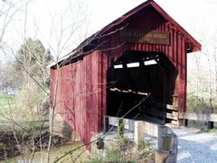 | Bean Blossom Covered Bridge | structure | 2022 | 100007441 |
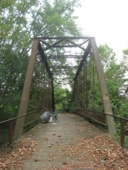 | Brown County Bridge No. 36 | structure | 1993 | 93001430 |
 | Brown County Courthouse Historic District | district | 1983 | 83000050 |
| Brown County State Park | district | 2020 | 100005867 | |
 | Thomas A. Hendricks House and Stone Head Road Marker | building | 1984 | 84000450 |
| Nashville Historic District | district | 2022 | 100008408 | |
 | Theodore Clement Steele House and Studio | building | 1973 | 73000029 |
| Story Historic District | district | 2019 | 100003500 | |
 | F.P. Taggart Store | building | 1983 | 83003559 |
Brown County has 1 covered bridge on the National Register. Each is a listed structure with a federal nomination on file.
| Bean Blossom Covered Bridge | Listed 2022 |
Every wildfire the federal occurrence database records inside this county: 28 of them, burning about 225 acres. None started naturally and 5 were recorded as arson. Each settlement page carries the fires within five miles of it.
| Reported cause | Fires |
|---|---|
| Debris and open burning | 14 |
| Recreation and ceremony | 7 |
| Arson/incendiarism | 5 |
| Equipment and vehicle use | 1 |
| Smoking | 1 |
The five largest, by the area the report gives. One of them was set deliberately.
| Date | Cause | Size | Reported by | Name on the report |
|---|---|---|---|---|
| 22 March 1995 | Arson/incendiarism | 47 acres | Hoosier National Forest | HOLLOW LOG |
| 4 November 1999 | Recreation and ceremony | 37 acres | Hoosier National Forest | ORIENT |
| 8 August 2012 | Equipment and vehicle use | 35 acres | Hoosier National Forest | FREEDOM |
| 11 January 2000 | Debris and open burning | 30 acres | Hoosier National Forest | BOBB |
| 5 February 2017 | Debris and open burning | 17 acres | Hoosier National Forest | HARRIS |
| 20 April 2016 | Recreation and ceremony | 13 acres | Hoosier National Forest | BROWN HOLLOW |
| 3 April 2011 | Debris and open burning | 5.0 acres | Hoosier National Forest | DECKARD RIDGE 2 |
| 15 March 2009 | Recreation and ceremony | 5.0 acres | Hoosier National Forest | 135 CAMPFIRE |
Every settlement page carries the fires within five miles of it - see the settlement index below.
The NOAA Storm Events Database holds 190 reports for this county, causing no deaths, 4 injuries and about $2,367,200 in recorded property damage. Each settlement page carries the reports that name it.
| Kind of event | Reports |
|---|---|
| Thunderstorm Wind | 112 |
| Hail | 39 |
| Flash Flood | 21 |
| Tornado | 7 |
| Flood | 6 |
| Heavy Rain | 2 |
| Funnel Cloud | 2 |
| Lightning | 1 |
The most serious of them, by death, then injury, then recorded damage. The accounts are quoted exactly as the forecast office filed them.
| When | Event | Place named | Harm | What the report says |
|---|---|---|---|---|
| June 1995 | Thunderstorm Wind | Needmore | 2 hurt, $5,000 | Two people were injured when a tree fell on a pickup truck. |
| September 1988 | Tornado (F1) | not stated | 1 hurt, $250,000 | no account filed |
| May 1996 | Lightning | Nashville | 1 hurt | no account filed |
| April 2025 | Flash Flood | Trevlac | $500,000 | One road was washed out with numerous other road closures. Roads remained closed for several days but the flash flooding threat only lasted a few hours. |
| June 2008 | Flash Flood | Fruitdate | $500,000 | Several evacuations occurred due to heavy rain that triggered flash flooding. Homes were flooded near Lake Lemon and multiple residents needed rescued. Sate Road 135 was closed. |
| June 2008 | Tornado (EF2) | Peoga | $200,000 | In Brown County near Peoga damaged occurred to twenty to thirty homes, a barn, powerlines, trees, and a carport due to a tornado. One indirect injury occurred when I firefighter suffered heat stroke. In Johnson County at Camp Atterbury forty buildings were damaged, dozens of vehicles including a 6,000 pound Humvee and a bus were tossed and crushed, the chapel was damaged, and a trailer was tossed on top of a building. Also in Johnson County in Edinburgh 59 buildings were damaged or destroyed. One woman suffered an ankle injury during the tornado. Damaged occurred in Shelby County to a gas station. One woman at the gas station sustained minor injuries when her car windows were blown out. The tornado touched down at 2024 EST in Brown County near the intersection of Sweetwater Trail and Beech Tree Road. The tornado tracked to the northeast for 2.83 miles before crossing into Johnson County approximately 1000 feet west of County Road 900 at 2030 EST. The tornado continued to track to the northeast for 7.19 miles until 2046 EST when the tornado entered Shelby County just south of the County Road 900 and West State Road 252 intersection. The tornado lifted at 2047 EST in Shelby County after tracking to the northeast and lifting at exit 80 on Interstate 65. The tornado was an EF-2 while in Brown County causing 200 thousand dollars in damage. The tornado was an EF-2 while in Johnson County causing 23 million dollars in damage. The tornado weakened to an EF-1 while in Shelby County causing 15 thousand dollars in damage. Based on damage indicators, at the tornadoes peak intensity wind speeds were around 130 miles per hour. The tornado formed from a supercell and was on the ground for 23 minutes or 10.59 miles. |
| April 2025 | Flash Flood | Nashville | $100,000 | Water flowing over a bridge on State Road 135. Several water rescues completed. Total rainfall ranged from 2.6 to 3.4 inches. |
| June 2021 | Flash Flood | Bethany | $100,000 | A house along State Road 135 South had rapidly rising flood waters enter the building. Damage was noted to several bridges across the rural portions of the county. |
| May 2022 | Thunderstorm Wind | Taggart | $50,000 | Widespread thunderstorm straight-line winds of 80 to 90 mph created significant uprooted and broken trees within a wide area as well along the damage path of a nearby brief, EF0 tornado. |
| June 2019 | Flash Flood | Nashville | $50,000 | Dispatch reports a crew headed to rescue residents that were possibly trapped after a small dam failure due to thunderstorm heavy rainfall. |
| May 2002 | Flash Flood | Countywide | $50,000 | no account filed |
| May 1996 | Tornado (F1) | Nashville | $50,000 | no account filed |
| April 2017 | Thunderstorm Wind | New Bellsville | $40,000 | Trees were reported down all across the township due to damaging thunderstorm wind gusts. Some of those trees were reported to be blocking roadways and delaying emergency responders. A tree also fell on a house, trapping a man inside. |
| May 2022 | Tornado (EF0) | Taggart | $30,000 | The first tornado to impact central Indiana on May 21st, an EF0 tornado, downed numerous trees in a convergent pattern through a densely wooded area. Peak winds estimated at 84 mph. |
| June 2019 | Flash Flood | Belmont | $30,000 | Dispatch reported very significant flooding ongoing south and west of Nashville due to thunderstorm heavy rainfall. Numerous road closures with portions of State Road 46 under water. Several water rescues were completed. |
| March 2025 | Thunderstorm Wind | Nashville | $25,000 | Numerous tree tops downed and trees toppled at the west gate of the Brown County State Park. |
| August 2020 | Thunderstorm Wind | Peoga | $25,000 | Trees down into power lines at Beech Tree and Nineveh roads. 18 other reports of trees down across Brown County. |
| November 2017 | Flood | Helmsburg | $25,000 | A trained spotter reported 6 to 9 inches of standing water on Lick Creek Road, north of State Road 45 due to heavy rainfall. Several vehicles were stalled in water. |
| January 2012 | Thunderstorm Wind | Nashville | $25,000 | Part of the roof on the Nashville Elementary School was blown off due to damaging thunderstorm wind gusts. Water damage occurred to some of the classrooms. |
| May 2002 | Flash Flood | Nashville | $25,000 | no account filed |
| May 1975 | Tornado (F0) | not stated | $25,000 | no account filed |
| August 2009 | Thunderstorm Wind | Bean Blossom | $20,000 | Damage was done to a house in the Woodland Lake area due to thunderstorm wind gusts. An amateur radio tower was blown down and a 2 inch steel diameter pipe was sheared off a wall. Multiple trees were down in this vicinity as well. The time this event occurred was estimated. |
| June 2025 | Thunderstorm Wind | Nashville | $15,000 | Thunderstorm wind gusts blew down a tree blown onto a car with people. |
| June 2025 | Flash Flood | Nashville | $15,000 | Rainfall, reported as great as 3.35 inches west-northwest of Nashville, produced flash flooding in the Nashville area. Water flowed over a bridge near the Nashville General Store. |
| April 2026 | Thunderstorm Wind | Christiansburg | $10,000 | Thunderstorm wind gusts downed multiple trees. |
| March 2026 | Flood | Belmont | $10,000 | Roadway flooding reported along Indiana Route 46 from Bloomington to Nashville. Creeks and drainage ditches were at capacity and some were overflowing. |
| June 2024 | Thunderstorm Wind | Beck Grove | $10,000 | A 75 mph thunderstorm wind gust was estimated at this location with numerous trees downed. |
| June 2021 | Thunderstorm Wind | Young | $10,000 | Significant tree damage caused by thunderstorm wind gusts in rural areas around Monroe Lake. |
| December 2021 | Thunderstorm Wind | Mt Liberty | $10,000 | Trees and power lines down by thunderstorm wind gusts all over Brown County. |
| June 2019 | Thunderstorm Wind | Trevlac | $10,000 | Trees and power lines were downed, all in the same direction, near Trevlac due to damaging thunderstorm wind gusts. |
| July 2015 | Thunderstorm Wind | Nashville | $10,000 | Multiple trees and power lines were downed due to damaging thunderstorm wind gusts. |
| July 2015 | Flash Flood | Gnaw Bone | $10,000 | A small portion of Brown Hill Road was washed out because of flooding due to heavy thunderstorm rainfall. |
| April 1998 | Flash Flood | Countywide | $10,000 | no account filed |
| July 2014 | Thunderstorm Wind | Nashville | $8,000 | Reports received of trees and power lines down near Highway 46 in Brown County due to damaging thunderstorm wind gusts. |
| July 2013 | Flash Flood | Christiansburg | $8,000 | Two women were rescued from a vehicle trapped in high water on Mount Nebo Road due to thunderstorm heavy rainfall. This report was received via Twitter. |
| June 2025 | Thunderstorm Wind | Story | $5,000 | Thunderstorm wind gusts downed a tree onto utility lines with 3 to 5-inch diameter branches broken off across State Road 135. |
| June 2023 | Thunderstorm Wind | Christiansburg | $5,000 | Thunderstorm winds downed trees in south-central Brown County. |
| April 2022 | Thunderstorm Wind | Taggart | $5,000 | Thunderstorm winds downed individual trees on Salt Creek Road and Valley Branch Road and Railroad Road. |
| March 2022 | Thunderstorm Wind | Cordry Lake | $5,000 | Tree damage caused by thunderstorm wind gusts on Ford Ridge Road. |
| April 2017 | Thunderstorm Wind | Gnaw Bone | $5,000 | Trees were reported to be down in the area due to damaging thunderstorm wind gusts. |
| July 2015 | Flash Flood | Nashville | $5,000 | Widespread flooding was occurring in Nashville due to heavy thunderstorm rainfall. |
| January 2008 | Flash Flood | New Bellsville | $5,000 | Heavy rain caused flash flooding and closed State Road 135 from Stone Head to State Road 46. |
| June 2008 | Flash Flood | Nashville | $5,000 | Roadways were covered and previous flooding conditions were exacerbated due to heavy rainfall that caused renewed flash flooding. |
| June 2008 | Flash Flood | Bean Blossom | $5,000 | Roadways were covered and previous flooding conditions were exacerbated due to heavy rainfall that caused renewed flash flooding. |
| August 1993 | Thunderstorm Wind | not stated | $5,000 | Trees and power lines were downed over the northern part of the county. |
| July 2023 | Thunderstorm Wind | Gnaw Bone | $4,000 | Thunderstorm winds downed 3 trees across southern Brown County. |
| July 2016 | Thunderstorm Wind | Story | $4,000 | Several trees were downed across the southern part of the county due to damaging thunderstorm wind gusts. |
| March 2025 | Thunderstorm Wind | Christiansburg | $3,000 | A 68 mph thunderstorm wind gust was measured at this location. Tree branches were snapped, and a trampoline was thrown 100 yards. |
| December 2025 | Thunderstorm Wind | Christiansburg | $3,000 | Thunderstorm wind gusts downed multiple trees in the area. |
| June 2022 | Thunderstorm Wind | Stone Head | $3,000 | Thunderstorm winds downed three trees onto Indiana Route 135 about 1 mile north of Van Buren Elementary School. |
| July 2020 | Thunderstorm Wind | Cordry Lake | $3,000 | Power poles and power lines downed due to thunderstorm wind gusts near Sweetwater Lake. |
| June 2019 | Thunderstorm Wind | Mt Liberty | $3,000 | Several large tree limbs were reportedly snapped along State Road 46, east of Nashville, due to damaging thunderstorm wind gusts. Power was reported to be out in Gnaw Bone as well. |
| July 2015 | Thunderstorm Wind | Helmsburg | $3,000 | Three trees were downed in the woods off of Lanam Ridge Road due to damaging thunderstorm wind gusts. Winds were estimated at 50 to 60 mph. |
| March 2026 | Thunderstorm Wind | Christiansburg | $2,000 | Several large tree limbs downed by thunderstorm wind gusts. |
| February 2026 | Thunderstorm Wind | Christiansburg | $2,000 | A 64 mph thunderstorm wind gust was recorded with a few tree branches snapped. |
| June 2025 | Thunderstorm Wind | Christiansburg | $2,000 | Multiple tree branches downed by thunderstorm wind gusts. |
| June 2022 | Thunderstorm Wind | Beck Grove | $2,000 | Thunderstorm winds downed one tree at each end of Garrity Road. Individual trees located at 2 miles east-northeast of Spurgeons Corner and 3 miles northwest of Waymansville. |
| September 2014 | Thunderstorm Wind | Doubling Track | $2,000 | A couple trees were reported down on Old Haggard Road due to damaging thunderstorm wind gusts. Power outages affected the area as well. |
| July 2013 | Flash Flood | Christiansburg | $2,000 | Christianburg Road was flooded and impassable, south of Hamilton Creek Road due to thunderstorm heavy rainfall. Rapidly flowing water was reported to be going into the backyards of homes near Spurgeons Corner. |
| January 2008 | Thunderstorm Wind | Nashville | $2,000 | Trees and power lines were reported down blocking State Route 135 due to damaging thunderstorm winds. |
The Survey's mineral resources record lists 4 workings inside this county. 1 still produces and 3 are closed or unrecorded. Each settlement page carries the workings within five miles of it.
| Commodity | Workings |
|---|---|
| Flagstone | 3 |
| Stone | 1 |
The least common of them first, because a county's hundredth gravel pit says nothing its first ten did not.
| Where | Site | Commodity | Status | Recorded |
|---|---|---|---|---|
| Brown County Highway Dept. | Stone | Producer | ||
| Brown County Native Stone Co Quarry | Flagstone | Past Producer | ||
| Brown County Stone Co Quarry | Flagstone | Past Producer | ||
| Lambert Dimension Sandstone Quarry | Flagstone | Past Producer |
Named settlements recorded in the Geographic Names Information System, each with the topographic sheets covering it. Villages, hamlets and abandoned places alike. Each is shown with the nearest named watercourse or landform and the survey quadrangle it falls on.
Washington township · 47448 · Near Watton Hill · Belmont quadrangle
20 sheets, 1942 to 1998
Jackson township · 46160 · On Hoppers Branch · Beanblossom quadrangle
23 sheets, 1942 to 1986
Jackson township · 46160 · Near Shipman Ridge · Morgantown quadrangle
21 sheets, 1942 to 1998
Van Buren township · 47235 · Near Cherry Hill · Story quadrangle
21 sheets, 1942 to 1986
No longer a settlement
Washington township · 47448 · Near Crouch Hollow · Nashville quadrangle
21 sheets, 1942 to 1998
Van Buren township · 47201 · Near Wilson Hollow · Story quadrangle
21 sheets, 1942 to 1986
Washington township · 47448 · Near Green Valley · Nashville quadrangle
21 sheets, 1942 to 1998
Hamblen township · 46164 · Near Renner Hill · Nineveh quadrangle
23 sheets, 1942 to 1998
Van Buren township · 47448 · On Spanker Branch · Elkinsville quadrangle
19 sheets, 1942 to 1993
Hamblen township · 46164 · Near Panther Lick Hollow · Beanblossom quadrangle
23 sheets, 1942 to 1986
Washington township · 47448 · On Mount Liberty Creek · Nashville quadrangle
21 sheets, 1942 to 1998
Van Buren township · 47201 · On South Branch Salt Creek · New Bellsville quadrangle
18 sheets, 1942 to 1986
Washington township · 47448 · On Henderson Creek · Nashville quadrangle
21 sheets, 1942 to 1998
Washington township · 47448 · On Jackson Branch · Belmont quadrangle
20 sheets, 1942 to 1998
Van Buren township · 47201 · Near Brand Hollow · Nashville quadrangle
21 sheets, 1942 to 1998
Jackson township · 47468 · Near Vaughn Hollow · Morgantown quadrangle
21 sheets, 1942 to 1998
Van Buren township · 47235 · Near Cherry Hill · Story quadrangle
21 sheets, 1942 to 1986
Van Buren township · 47448 · On Pleasant Valley Creek · Nashville quadrangle
21 sheets, 1942 to 1998
Hamblen township · 46164 · Near Renner Hill · Beanblossom quadrangle
23 sheets, 1942 to 1986
Hamblen township · 47448 · On Sweetwater Creek · Beanblossom quadrangle
23 sheets, 1942 to 1986
Washington township · 47448 · On Greasy Creek · Nashville quadrangle
21 sheets, 1942 to 1998
Washington township · 47448 · Near Kelley Hill · Belmont quadrangle
20 sheets, 1942 to 1998
Washington township · 47448 · On Will Hay Branch · Elkinsville quadrangle
19 sheets, 1942 to 1993
No longer a settlement
The vanished settlements of Brown County: the places named above that are no longer on the map.