 Block
From the record
3 National Register listings published here.
Sources: the National Register database, National Park Service
43 topographic sheets cover 12 settlements here, and 3 properties are on the National Register of Historic Places.
3 National Register listings published here.
Sources: the National Register database, National Park Service
Every property in this county listed on the National Register of Historic Places, with the year it was listed and the federal nomination document.
| Photograph | Property | Type | Listed | Reference |
|---|---|---|---|---|
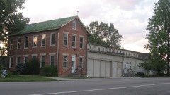 | Clore Plow Works-J.W. Whitlock and Company | building | 1999 | 99001152 |
 | Rising Sun Historic District | district | 2006 | 06000935 |
| Speakman-Miller-Kittle Farm | district | 2023 | 100009592 |
The NOAA Storm Events Database holds 103 reports for this county, causing no deaths, 64 injuries and about $1,202,600 in recorded property damage. Each settlement page carries the reports that name it.
| Kind of event | Reports |
|---|---|
| Thunderstorm Wind | 66 |
| Flash Flood | 17 |
| Hail | 11 |
| Tornado | 6 |
| Flood | 3 |
The most serious of them, by death, then injury, then recorded damage. The accounts are quoted exactly as the forecast office filed them.
| When | Event | Place named | Harm | What the report says |
|---|---|---|---|---|
| April 1974 | Tornado (F4) | not stated | 64 hurt | no account filed |
| August 1993 | Thunderstorm Wind | not stated | $500,000 | no account filed |
| January 2000 | Flash Flood | Rising Sun | $100,000 | Heavy rainfall caused Bear Creek Road to be closed. Also, the 4th Street Bridge in Rising Sun was washed out. |
| September 2022 | Flash Flood | Aberdeen | $55,000 | Several creeks were out of their banks in the vicinity of Aberdeen Road, mainly to the west of Aberdeen. |
| April 2024 | Tornado (EF1) | Bear Branch | $50,000 | The tornado developed near the Ohio and Switzerland County line, just north of Aberdeen Road. A garage was destroyed on the north side of Aberdeen Road and a well constructed barn on Aberdeen Road was completely destroyed. Much of the debris from this barn was lofted high into the trees behind the barn. Winds at this location were estimated to be around 100 mph. The tornado then continued east through wooded and inaccessible areas, eventually crossing Bear Branch Creek and Texas Gas Road before it dissipated near Milton Bear Branch Road. Along this path, numerous trees were uprooted. |
| April 2020 | Tornado (EF0) | Milton | $50,000 | The tornado first touched down along Milton Bear Branch Road in western Ohio County. The tornado traveled east southeast until it lifted near the 6000 block of Palmer Road. There were numerous occurrences of damage to roofs, siding, barns and trees. Damage of this nature was consistent with an EF0 tornado, with winds topping out at about 70 to 75 mph. |
| March 2017 | Thunderstorm Wind | Milton | $50,000 | A farm residence on Hartford Pike Road was damaged, where a house had the top of its roof removed, and several large trees on the nearby hillside were toppled. Tree damage was observed along Laughery Creek and adjacent portions of Hartford Pike Road along the Dearborn/Ohio County border. Structural damage was also observed at several locations along Salem Ridge Road and Belleview Lane, with minor roof damage to homes, and significant damage or destruction of a few barns and garages. This was near the end of a swath of about 13 miles of damage that extended back into Dearborn County. The damage was consistent with winds in the 70 to 80 mph range. |
| March 2017 | Thunderstorm Wind | Cofield Corner | $40,000 | Three properties along Indiana State Route 56, a few miles west of the Ohio River, sustained damage, starting in the west near Stewart Ridge Road and running about a mile to the east. Several outbuildings and garages were significantly damaged, though homes suffered only minor roof and siding damage. Tree damage in this area was scattered but there were a few uprootings and a couple areas where trees were snapped. The damage was consistent with winds in the 70 to 80 mph range. |
| October 2016 | Thunderstorm Wind | Rising Sun | $25,000 | Damage occurred to both the high school and elementary-middle schools allowing leaks to produce some water damage. |
| October 2016 | Thunderstorm Wind | Rising Sun | $25,000 | A large tree was uprooted and fell on a ranch style house, collapsing part of the home. |
| April 2020 | Tornado (EF0) | Cofield Corner | $20,000 | The tornado first touched down along the 7300 block of Salem Ridge Road and tracked 5.25 miles to the east, before lifting near Rising Sun. Damage to roofs, siding, power poles and trees occurred, with damage becoming more diffuse and sparse as the storm headed east. |
| April 2020 | Tornado (EF0) | Bear Branch | $20,000 | The tornado briefly touched down in far southwest Ohio County, about 5 miles east-southeast of Cross Plains, in the 1600 block of Aberdeen Road. The tornado destroyed a barn and produced siding and roof damage, as well as rolling 2 recreational vehicles and toppling trees. ||Based on the degree of damage, the tornado produced winds of around 70 mph. |
| October 2016 | Thunderstorm Wind | Rising Sun | $20,000 | Numerous trees and large branches in Rising Sun where knocked down. |
| April 2011 | Thunderstorm Wind | Rising Sun | $20,000 | A barn was knocked down and destroyed due to damaging thunderstorm winds. A roof was blown off of a garage and a tree was snapped due to the winds. |
| August 1998 | Thunderstorm Wind | Milton | $20,000 | Strong winds damaged a barn roof. |
| February 2000 | Flash Flood | Bear Branch | $15,000 | Razor Hill Road washed out due to several hours of heavy rainfall. |
| March 2025 | Thunderstorm Wind | Rising Sun | $10,000 | A home was damaged and the exterior walls of a barn were collapsed. |
| May 2018 | Thunderstorm Wind | Aberdeen | $10,000 | A barn was destroyed on a property off of Cass Union Road. |
| March 2017 | Thunderstorm Wind | Cofield Corner | $10,000 | Numerous trees were downed across the county. |
| October 2016 | Thunderstorm Wind | Rising Sun | $10,000 | The press box at the high school softball field was destroyed and blown into the road. |
| May 2006 | Thunderstorm Wind | Aberdeen | $10,000 | A roof was peeled off of a barn. Several trees were downed. |
| January 2005 | Flash Flood | Rising Sun | $10,000 | Several roads in and around town were flooded and closed. |
| March 2025 | Thunderstorm Wind | Rising Sun | $8,000 | A car park roof was uplifted and a small outbuilding sustained damage. |
| April 2006 | Thunderstorm Wind | Countywide | $6,000 | Several trees were downed throughout the county. |
| July 2023 | Thunderstorm Wind | Bear Branch | $5,000 | Several trees were downed across the western part of the county. |
| July 2002 | Thunderstorm Wind | Rising Sun | $5,000 | A few trees were blown down. |
| October 2001 | Thunderstorm Wind | Countywide | $5,000 | Trees were knocked down across the county. |
| November 2000 | Thunderstorm Wind | Rising Sun | $5,000 | Numerous trees knocked down by thunderstorm winds. |
| August 2000 | Thunderstorm Wind | Countywide | $5,000 | Trees and power lines downed. |
| June 1997 | Flash Flood | Rising Sun | $5,000 | Heavy rainfall caused Rt. 56 to flood to the north of Rising Sun. |
| June 2025 | Thunderstorm Wind | Rising Sun Arpt | $4,000 | Several trees were downed on the north side of Rising Sun. |
| December 2021 | Thunderstorm Wind | Rising Sun | $4,000 | Several trees were downed in the Rising Sun area. |
| May 1996 | Thunderstorm Wind | Countywide | $4,000 | no account filed |
| July 2023 | Thunderstorm Wind | Cofield Corner | $3,000 | A few trees were downed along White Road. |
| September 2022 | Thunderstorm Wind | French | $3,000 | A few trees were downed on State Route 56. |
| September 2022 | Thunderstorm Wind | Hartford | $3,000 | A few trees were downed along Salem Ridge Road. |
| July 2008 | Thunderstorm Wind | Rising Sun | $3,000 | Trees and power lines were downed. |
| June 2008 | Thunderstorm Wind | Rising Sun | $3,000 | Numerous trees and limbs were blown down. |
| July 2006 | Thunderstorm Wind | Rising Sun | $3,000 | Trees and powerlines were downed. |
| July 2006 | Thunderstorm Wind | Hartford | $3,000 | Trees were knocked down. |
| December 2006 | Thunderstorm Wind | Rising Sun | $3,000 | A few large tree limbs were downed. |
| June 2005 | Thunderstorm Wind | Rising Sun | $3,000 | Trees were knocked down. |
| July 2003 | Thunderstorm Wind | Rising Sun | $3,000 | Trees and limbs were downed. |
| April 2001 | Thunderstorm Wind | Rising Sun | $3,000 | A few trees were knocked down. |
| July 2001 | Thunderstorm Wind | Countywide | $3,000 | Trees knocked down. |
| July 1999 | Thunderstorm Wind | Rising Sun | $3,000 | Numerous trees downed. |
| November 1998 | Thunderstorm Wind | Rising Sun | $3,000 | Trees knocked down. |
| March 1997 | Thunderstorm Wind | Rising Sun | $3,000 | no account filed |
| May 1996 | Flash Flood | Countywide | $3,000 | no account filed |
| April 1996 | Flash Flood | Countywide | $3,000 | no account filed |
| June 2022 | Thunderstorm Wind | Bear Branch | $2,000 | A tree was downed on Aberdeen Road. Another tree was downed on Willow Creek Road. |
| March 2019 | Thunderstorm Wind | Rising Sun | $2,000 | A couple of trees were downed along Nelson Road outside of Rising Sun. |
| July 2018 | Thunderstorm Wind | Rising Sun | $2,000 | A tree fell onto a power line near 2nd Street. |
| May 2018 | Thunderstorm Wind | Pate | $2,000 | A few trees were downed. |
| July 2007 | Thunderstorm Wind | Rising Sun | $2,000 | One tree and one large limb were knocked down. |
| May 2004 | Thunderstorm Wind | Rising Sun | $2,000 | Large limbs were knocked down. |
| June 1999 | Thunderstorm Wind | Rising Sun | $2,000 | Trees were knocked down across the county. |
| March 2025 | Thunderstorm Wind | Rising Sun | $1,000 | A large tree was uprooted along Main Street. |
| August 2018 | Thunderstorm Wind | Milton | $1,000 | A tree was knocked down. |
| June 2018 | Thunderstorm Wind | Rising Sun | $1,000 | One tree was knocked down on Nelson Road. |
The Survey's mineral resources record lists 1 working inside this county. It still produces. Each settlement page carries the workings within five miles of it.
| Commodity | Workings |
|---|---|
| Sand and Gravel, Construction | 1 |
The least common of them first, because a county's hundredth gravel pit says nothing its first ten did not.
| Where | Site | Commodity | Status | Recorded |
|---|---|---|---|---|
| O'Day Excavating & Gravel Company | Sand and Gravel, Construction | Producer |
Named settlements recorded in the Geographic Names Information System, each with the topographic sheets covering it. Villages, hamlets and abandoned places alike. Each is shown with the nearest named watercourse or landform and the survey quadrangle it falls on.
Cass township · 47040 · Near Carmel Ridge · Aberdeen quadrangle
12 sheets, 1943 to 1986
Pike township · 47018 · Near Mexico Ridge · Bear Branch quadrangle
8 sheets, 1956 to 1990
Randolph township · 47001 · Near Thuermer Hollow · Aurora quadrangle
19 sheets, 1915 to 1986
Randolph township · 47001 · On Island Branch · Rising Sun quadrangle
12 sheets, 1943 to 1986
Randolph township · 47040 · On Arnold Creek · Rising Sun quadrangle
12 sheets, 1943 to 1986