 Block
From the record
18 National Register listings published here, 1 of them a National Historic Landmark.
Sources: the National Register database, National Park Service
76 topographic sheets cover 35 settlements here, and 18 properties are on the National Register of Historic Places.
18 National Register listings published here, 1 of them a National Historic Landmark.
Sources: the National Register database, National Park Service
Every property in this county listed on the National Register of Historic Places, with the year it was listed and the federal nomination document.
| Photograph | Property | Type | Listed | Reference |
|---|---|---|---|---|
 | Thomas Newby Braxtan House | building | 1989 | 89000777 |
 | Dixie Garage | building | 2001 | 01000983 |
 | First Baptist Church | building | 1994 | 94000234 |
| French Lick Methodist Episcopal Church | building | 2026 | 100012759 | |
 | French Lick Springs Hotel | district | 2003 | 03000972 |
 | Homestead Hotel | building | 1998 | 98001057 |
 | Jenkins Place | district | 2010 | 10000127 |
 | Thomas Elwood Lindley House | building | 1985 | 85002132 |
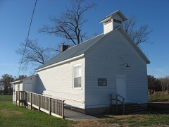 | Lynd School | building | 2002 | 02001169 |
 | Newberry Friends Meeting House | building | 1996 | 95001534 |
 | Orange County Courthouse | building | 1975 | 75000009 |
 | Orleans Historic District | district | 2009 | 09000761 |
 | Oxford Hotel | building | 2001 | 01000977 |
 | Paoli Historic District | district | 1994 | 94001355 |
| Shindler-Stetson House | building | 2021 | 100006565 | |
| The Maples Farm | building | 2026 | 100012768 | |
 | West Baden National Bank | building | 1993 | 93000950 |
 | West Baden Springs Hotel | building | 1974 | 74000016 |
Every wildfire the federal occurrence database records inside this county: 84 of them, burning about 516 acres. 1 started naturally and 6 were recorded as arson. Each settlement page carries the fires within five miles of it.
| Reported cause | Fires |
|---|---|
| Debris and open burning | 47 |
| Missing data/not specified/undetermined | 9 |
| Arson/incendiarism | 6 |
| Recreation and ceremony | 6 |
| Smoking | 5 |
| Equipment and vehicle use | 5 |
| Power generation/transmission/distribution | 3 |
| Misuse of fire by a minor | 2 |
| Natural | 1 |
The five largest, by the area the report gives. Two of them were set deliberately.
| Date | Cause | Size | Reported by | Name on the report |
|---|---|---|---|---|
| 12 April 2018 | Debris and open burning | 77 acres | Hoosier National Forest | PIPELINE |
| 24 March 2001 | Debris and open burning | 75 acres | Hoosier National Forest | ELK |
| 23 February 2000 | Smoking | 40 acres | Hoosier National Forest | GERALD CORNER |
| 28 February 2004 | Debris and open burning | 30 acres | Hoosier National Forest | WASHINGTON FIRE |
| 15 February 2002 | Arson/incendiarism | 30 acres | Hoosier National Forest | LIBERTY FIRE |
| 4 March 2006 | Debris and open burning | 20 acres | Hoosier National Forest | PATOKA LAKE |
| 31 March 2015 | Debris and open burning | 20 acres | Hoosier National Forest | TONY'S MARINE |
| 9 November 2005 | Arson/incendiarism | 20 acres | Hoosier National Forest | PATOKA |
Every settlement page carries the fires within five miles of it - see the settlement index below.
The NOAA Storm Events Database holds 249 reports for this county, causing no deaths, 1 injury and about $4,419,060 in recorded property damage. Each settlement page carries the reports that name it.
| Kind of event | Reports |
|---|---|
| Thunderstorm Wind | 121 |
| Hail | 63 |
| Flash Flood | 35 |
| Tornado | 23 |
| Flood | 4 |
| Lightning | 2 |
| Heavy Rain | 1 |
The most serious of them, by death, then injury, then recorded damage. The accounts are quoted exactly as the forecast office filed them.
| When | Event | Place named | Harm | What the report says |
|---|---|---|---|---|
| March 2017 | Tornado (EF1) | Leipsic | 1 hurt, $75,000 | This is an extension of the Lawrence County EF-2 tornado that briefly crossed into Orange County before lifting. The tornado produced EF-1 level damage in Orange County, destroying two mobile homes. One mobile home rolled over onto a new vehicle where three occupants were unhurt. The car ended up inside the living room of the mobile home. The other mobile home took a direct hit, taking the roof off and blowing the walls out of half of the home. An occupant of the home was blown into the field with home debris, while leaving living room furniture in place. The resident received only minor injuries. |
| June 1990 | Tornado (F4) | not stated | $2,500,000 | no account filed |
| May 2004 | Flash Flood | Paoli | $250,000 | There was extensive flooding of a residential area in the northern part of Paoli. The worst flooding was on Charles Street and Autumn Drive. Two homes were swept off their foundations by flowing waters. Several residents in the area had to be evacuated by boat. |
| May 2004 | Thunderstorm Wind | Chambersburg | $250,000 | An antique shop was destroyed by thunderstorm winds. Some trees were thrown on to homes. Numerous trees and power lines were downed. |
| June 1980 | Tornado (F1) | not stated | $250,000 | no account filed |
| April 1974 | Tornado (F1) | not stated | $250,000 | no account filed |
| May 2011 | Tornado (EF2) | Orleans Arpt | $150,000 | This tornado touched down along Highway 37 south of Orleans, uprooting and snapping several trees. It expanded to its maximum width and strength one mile into its path, where it heavily damaged two brick homes and one wooden frame home, as well downing power lines and poles. In this area it also did extensive damage to several outbuildings, completely destroying one barn and overturning a tractor within. The tornado continued to the northeast, damaging another outbuilding a mile to the northeast and uprooting and snapping numerous trees before finally lifting in an open field 3/4 mile southwest of the community of Leipsic. |
| November 2011 | Tornado (EF1) | Paoli | $100,000 | A tornado first touched down on the north side of the Paoli school complex three quarters of a mile west of the downtown square. It destroyed a 100 year old barn and heavily damaged the roofs of two other outbuildings. It then removed a large section of roofing from the Paoli police department on West Main Street before snapping several trees along Lick Creek. Based on a damage survey, this tornado was classified as an EF-1 with peak winds from 95 to 100 mph between its initial touchdown and the Paoli town square. While moving across the town square, this tornado ripped the metal roofs off of two businesses. Three chimneys on the Orange County Courthouse collapsed. Moving east of the town square, the tornado traveled another mile and a quarter, weakening to EF-0 status while uprooting many trees and damaging the roofs of several homes. Before lifting next to North Marshall Road, the tornado damaged a metal outbuilding. |
| April 2006 | Thunderstorm Wind | Paoli | $100,000 | Several homes sustained major roof damage. A new modular home was blown off its foundation. Trees and power lines were downed in the area. A storm spotter estimated a 100 MPH wind gust. |
| March 2017 | Thunderstorm Wind | Leipsic | $75,000 | A NWS Storm Survey team found that thunderstorm winds destroyed an outbuilding approximately 1/2 mile northwest of Leipsic. The damaging winds continued into the community, scattering debris from the outbuilding and damaging several homes in town. The winds winds tore part of the roof off one home, fanning debris to the east. The estimated time of the event was 1 minute. |
| March 2017 | Thunderstorm Wind | Chambersburg | $75,000 | A NWS Storm Survey in conjunction with Orange County Emergency Management concluded that straight line winds impacted a nearly 2 mile stretch along US Highway 150 southeast of Paoli. The hardest hit areas was southeast of Paoli where damage occurred to roofs and numerous softwood trees were uprooted. A truck was completely smashed by a downed tree, along with roof and foundation damage to a house from a fallen tree. Max winds were estimated between 75 and 80 mph along the sporadic half mile wide path. |
| August 2001 | Lightning | French Lick | $75,000 | A house was destroyed in a fire caused by lightning. |
| July 2010 | Lightning | Fargo | $50,000 | A barn was struck by lightning and completely destroyed in the resulting fire. The time is approximate. |
| August 2018 | Thunderstorm Wind | Paoli | $30,000 | Multiple trees were reported down on the western side of Paoli. There were also several power outages. |
| December 2015 | Thunderstorm Wind | Fargo | $25,000 | The Orange County emergency manager reported to the NWS that severe thunderstorm winds severely damaged two barns. |
| January 2013 | Tornado (EF0) | Prospect | $25,000 | An EF-1 tornado damaged portions of a forest and a residence located just over 3 miles north of West Baden Springs, Indiana. Maximum wind speeds estimated around 85 to 95 mph accompanied this twister, which had a width of 75 yards and a length of 400 yards. EF-1 damage was surveyed at one home, where the roof was badly damaged. The porch of this home was thrown several feet. Several small twigs were driven through this resident's siding. |
| October 1959 | Tornado | not stated | $25,000 | no account filed |
| July 2017 | Thunderstorm Wind | French Lick | $20,000 | The public reported trees and power poles down in the area. |
| May 2011 | Tornado (EF1) | Leipsic | $20,000 | Beginning in an open field less than a quarter of a mile south of the Orange/Lawrence County line, this tornado tracked northeastward for 3.2 miles across portions of three counties. Near its touch down 3.1 miles northwest of Saltillo, it destroyed a large wooden barn and uprooted several trees on the south side of Suddarth Ln before entering Lawrence County. It had a path length of 0.3 miles in Orange County. |
| June 2018 | Thunderstorm Wind | Paoli | $15,000 | State officials reported power lines down on Water Street in Paoli. |
| December 2015 | Thunderstorm Wind | Rego | $15,000 | An amateur radio operator reported that severe thunderstorm winds resulted in minor roof damage. In addition, severe winds lifted an aluminum carport off its foundation. |
| July 2012 | Thunderstorm Wind | Orleans Arpt | $15,000 | Local law enforcement observed downed power lines and a large tree that had fallen on a vehicle. |
| December 2015 | Thunderstorm Wind | Orleans Arpt | $10,000 | Local law enforcement officials reported that power lines were down near Highway 37 near Orleans. Officials also reported that numerous trees were down elsewhere in Orange County. |
| February 2011 | Thunderstorm Wind | Valeene | $10,000 | Straight line wind damage was reported at 3 separate points north of Valeene. About 2 miles northwest of Valeene an outbuilding was destroyed and a large cedar tree was uprooted. The cedar tree broke an electric pole and pulled wires down to the ground. |
| March 2016 | Thunderstorm Wind | French Lick | $5,000 | A broadcast media meteorologist relayed a report of a roof blown off a gas station due to severe thunderstorm winds. |
| August 1954 | Tornado (F2) | not stated | $2,500 | no account filed |
| October 2010 | Thunderstorm Wind | French Lick | $1,000 | Power poles were broken. |
| June 1994 | Thunderstorm Wind | not stated | $500 | Numerous trees were blown down across many parts of the county. |
| June 1990 | Tornado (F1) | not stated | $30 | no account filed |
| July 1987 | Tornado (F0) | not stated | $30 | no account filed |
| April 2026 | Flash Flood | Braxton | - | County Road 240 South was closed due to high water at Log Creek. |
| April 2026 | Flash Flood | French Lick | - | There was a water rescue after a car ended up in a creek in French Lick. |
| April 2026 | Thunderstorm Wind | French Lick | - | There were multiple trees down just south of French Lick along State Road 145. |
| April 2026 | Thunderstorm Wind | Youngs Creek | - | There were multiple trees down in Greenfield Township near West County Road 560 South. |
| March 2026 | Hail | Rego | - | Nickel to quarter size hail was observed in the eastern part of Orange County, near the Rego community. In French Lick and Paoli, smaller hailstones covered the ground. |
| March 2025 | Tornado (EF1) | West Baden Spgs | - | The National Weather Service conducted a storm survey for the storms that occurred in Orange County early Saturday morning, March 15th 2025. A tornado was determined to have occurred in West Baden Springs and continued for about 11 miles to the|northeast to Orleans with a maximum wind speed of 110 mph and a max width of 50 yards. The first damage to have occurred was along West Sinclair Street in West Baden Springs where several trees were observed to be snapped about 20 feet in height from|the ground level. Power lines were also observed to be down on North Hopkins Street. Some minor damage to homes occurred in the neighborhood along Sinclair Street. The tornado continued east of Sinclair Street to rural portions of West Baden Springs where|tree damage was observed, as well as extensive roof damage to a residence in the hills east of West Baden Springs. Estimated wind speeds were between 90 and 100 mph at these locations.||The tornado continued to the northeast across West County Pike Road, Abbeydell Pike, and US Highway 150. Damage was observed in a neighborhood to the north of US Highway 50 where several trees had damage and some minor home damage was observed. Some debris splatter occurred to one home in this neighborhood on both sides of the home, and the homeowner commented about hearing the roar of the wind and the shaking of the house as the tornado passed by the home. The tornado continued to the northeast and struck a barn and did extensive roof damage as well as flipping an unanchored mobile home. The tornado continued along North County|Road 590 West to the northeast where another metal barn had collapsed. Wind speeds varied between 70 and 90 mph in this area.||The tornado continued to the northeast along mainly rural portions of Orange County north of Pipher Hollow where a residence had tree damage and roof damage on the southwest corner of the home. Shingles and insulation were thrown and lofted into|nearby trees mainly to the northeast. The tornado continued along West County Road 350 North where isolated tree snaps were observed with some minor siding damage to structures. The tornado then moved across North County Road 200 West and West|County Road 500 North where 6 power lines were snapped and a barn had some roof panels peeled off. Wind Speeds were estimated between 60 and 80 mph in these areas. ||The tornado moved to the northeast across Lost River area where a home and several outbuildings had extensive damage from the tornado. At least a dozen trees were snapped at this location just to the west of North County Road 100 West. A pole barn garage was completely collapsed, and the insulation to the garage was lofted into nearby trees at least 30 feet high. The roof to the garage was lofted past the tree line north of the property and landed in a nearby field to the north. The snaps at this location were in various directions from the swirling tornado winds. The homeowner |commented about the roaring of the tornado, and had felt the air leaving the house in a rush and returning after the tornado passed. The strongest winds from the tornado occurred at this location where estimated winds were around 110 mph.||The tornado continued along North County Road 100 West where a tree line captured the width of the tornado. Several trees were snapped along the tree line, where other trees on either side of the path were untouched. The tornado was about 50 yards wide at this location with estimated wind speeds of about 100 mph. The tornado then continued to the northeast to the town of Orleans where several tree snaps occurred along South 6th Street and West Harding Street. The tornado then struck a pole barn residence where the roof was thrown to the north of the building and insulation was blown into nearby trees. The tornado continued to the northeast where a church had roof damage at South Second Street. After this point, the tornado lifted and no additional damage was observed. |
| March 2025 | Thunderstorm Wind | Prospect | - | A tree fell down and blocked US 150 near 725 West. |
| June 2025 | Hail | Greenbrier | - | Quarter sized hail was observed along South County Road 490 West in southern Orange County. |
| June 2025 | Hail | Youngs Creek | - | Quarter size hail was observed near the intersection of West County Road 525 South and County Road 550 South. |
| July 2024 | Thunderstorm Wind | French Lick | - | Trees down in French Lick. |
| March 2023 | Hail | Orleans Arpt | - | Quarter sized hail was observed in Orleans. |
| March 2023 | Thunderstorm Wind | Paoli | - | Trees were blown down along State Route 37 near Paoli in addition to other locations across the county. |
| June 2023 | Hail | French Lick | - | One inch hail was reported at the French Lick Resort. |
| June 2023 | Hail | French Lick | - | A picture of large hail was on social media. |
| June 2023 | Hail | Abydel | - | Hail fell at a storm spotter's home. |
| August 2023 | Tornado (EF1) | French Lick | - | The tornado began along S Indiana Ave where several large hardwood trees had branches snap towards the east. Some homes saw side wall paneling damage as well as roofing cover damage. Damage continued along W Summit Circle Dr where several more large hardwoods were uprooted and snapped.||The main area of damage is located just south of the downtown area of French Lick on Skyline Drive. This is an area of higher elevation that saw multiple large hardwood trees snapped, some houses saw shingles and side paneling damage. This is where the highest wind speeds of 107 mph would have occurred based on damage making this tornado an EF1.The tornado then made its way northeast to S Summit St where one home saw significant sidewall damage on both its north and south side, as well as paneling damage.||The tornado then tracked southeast towards W County Road 100 S where it appeared to weaken. Several smaller hardwoods saw their limbs broken off and debris was spread out towards the north. A small sandbox outbuilding had its roof torn off and|debris fell just slightly east of the structure. Surrounding trees were bent towards the east and northeast. The winds in this area topped out at 85 mph based on the damage seen. |
| August 2023 | Tornado (EF1) | Paoli | - | The first damage point had a few topped and twisted trees near Red Bud Lane and Hospital Rd. Wind speeds were between 75 and 80 mph with a 50 yard width. There was sporadic tree damage along a creek, and tree damage became more concentrated along Apache and Slaten Drive with trees twisted, topped, and one uprooted tree. Wind speeds increased to 85 to 90 mph with a width of 75 yards. The width increased to 100 yards along Sandy Hook Road and Paul Street with wind speeds around 90 mph. There were several trees on homes, and increased twisting of the trees with damage going from the east southeast to the north northeast. There were numerous power poles and powerlines down between Indiana 37 and Paul Street.||The peak of the tornado damage was on the east side of Indiana 37 between Locust Street and Oak Street. Several warehouses had significant roof damage with debris thrown from east southeast to north northeast. There were several cars that had debris on the west and east side of them. The debris from the warehouse was thrown into a forested area up to 200 yards in distance. Wind speed in this area were 100 mph with a width of 110 yards. The NWS drone was key to the survey, with drone imagery capturing trees snapped, topped, and uprooted several hundred yards east of the last warehouse. There was a lot of straight line wind damage between the two different tornadoes in Paoli. |
| August 2023 | Tornado (EF0) | Paoli | - | There was plenty of straight-line tree damage from just south of the courthouse in Paoli all the way to the Pioneer Mothers Park of Hoosier National Forest. Across from the park (west side of Indiana Hwy 37) at a residence, there were many trees and large limbs down from straight-line winds (west to the east direction) of 65 mph on the south side of the property and further south on Indiana Hwy 37.||However on the north side of the property, cedar trees were twisted and debris thrown to a north-northeasterly direction. A sycamore tree was snapped with debris going from the east-northeast all the way to a northerly direction.||The survey team spoke to hikers attempting to hike down the Pioneer Mothers Park trail and it was impassable due to trees uprooted, twisted, snapped and topped. The hikers showed pictures of the dozens and dozens of snapped and uprooted trees going from the east- northeast to the north-northeast direction. This EF0 tornado had max wind speeds of 85 mph with a width of 60 yards wide.||The NWS Drone was key to the survey, with drone imagery capturing trees snapped, topped, and uprooted well into the forest. The drone was flown to a large quarry near Highway 150 with all tree damage all facing west to east direction. |
| August 2023 | Tornado (EF1) | Braxton | - | The tornado first touched down on the west side of Paoli near the intersection of West Main Street and Willowcreek Road. It then moved eastward, hitting a warehouse on the north side of West Main Street while causing some damage to the roof and soffits. Winds speeds were around 85 mph with a width of 50 yards.||There was sporadic shingle and gutter damage to businesses along West Main Street on the west side of Paoli, with roofing material displaced and several trees snapped and twisted. The roofing material was spread out from a northerly to an easterly direction. There were at least two large trees on homes, laying in a north to northeasterly direction. The Jesus Christ Latter-Day Saints Church had most of their windows blown out, as well as roof damage. An anchored sign had been blown over, facing almost due north. Winds were estimated at 90 mph with the tornado`s width increasing to 75 yards.||Several taller buildings at the square in Paoli had significant damage to brick fascia and roofing material was uplifted. The court house had several large chimneys down, and street signs were bent over more than 45 degrees. Damage was thrown several hundred yards to the north and east. Winds were estimated at 100 mph with a width of|75 yards.||There were numerous snapped and twisted trees along Indian Trail Road, with 75 trees down across Green Acres Golf Course. Additionally, there were many snapped, topped, and uprooted trees along Indiana State Road 56 with dozens of trees down on Blueberry Hill Estate. Winds were estimated to be 90 mph with a width increasing to 175 yards. Along Indiana State Road 56 between Limeberry Road and Tater Road, there were 7 barns sustaining roofing and gutter damage. Drone photography was able to detail large swirls in the corn and soybean fields adjacent to the property.||The most impressive damage was to two grain storage tanks, weighing over 50,000 pounds, with a collapse from the southwest to northeasterly direction. NWS drone photography did not show much damage to an adjacent corn field, and surveyors estimated winds at 100 mph at this point with a width of 150 yards.||There were dozens of power poles and lines down all along Indiana State Road 56 approaching Badger Family Farms. The last damage point was near County Road 700 and Indiana State Road 56 with some trees topped and twisted. Winds were estimated at 80 mph with an estimated tornado width of 50 yards. This is approximately 1 mile from the Washington County line on Indiana|State Road 56. |
| August 2023 | Tornado (EF1) | French Lick Muni Arp | - | The tornado first touched down in Dubois County near County Rd 200 West and Haysville Rd. After crossing into Orange County, the tornado continued about a mile and a half east where drone footage as well as tree snapping and uprooting indicated a slight convergence pattern towards the northeast. Multiple vehicles, trailers, and mobile homes were rolled over into the forest towards the northeast. This area along South County Road 1050 W sustained significant and extensive damage as compared to areas just west. The tornado continued to track in the east-northeast direction. Drone footage from trees and cornfields also indicate convergence. Most of the worst damage was observed just north of the French Lick airport.||As the tornado tracked northeastward, large swaths of trees were snapped and uprooted. Some homes saw minor roof and wall paneling damage. Areas just east of W County Road 150 S saw extensive tree damage where a path of about 200 yards wide experienced 105 mph winds according to the damage observed in the forest.||Just southwest of Paoli, near S county Road 225 and heading northeast towards S Thompson Lane, a path of significant damage affected multiple homes and created a vast debris field toward the northeast. The entire western side of a home had sidewall and paneling ripped off part of the roof. Part of the actual roof was also ripped off. Tree next to it also snapped. There was lots of debris to the northeast and house insulation in the fences and trees. A barn located on the edge of a clearing near a cornfield was mostly flattened towards the northeast.||Thompson lane saw major tree damage with large swaths of trees being snapped in a northeast direction and some slight convergence seen from drone footage. The tornado ended here with no observed damage to the east from this tornado track on the southwest side of Paoli. In total, the tornado was rated EF1 with 107 mph maximum|winds and was a continuous track for 25.89 miles, which is a record long tornado for August in the NWS Louisville county warning area. This breaks the previous known record for long track tornado in August of 4 miles in Jefferson County, IN on August |14, 2002. |
| May 2022 | Hail | Valeene | - | There was quarter to half dollar sized hail near Valeene. |
| August 2021 | Flash Flood | Prospect | - | There were several reports of closed roads due to flooding across the county, including Orangeville Road near Prospect. |
| April 2020 | Thunderstorm Wind | Abydel | - | There were multiple reports of tree damage and power lines down across Orange County. |
| July 2020 | Thunderstorm Wind | Paoli | - | There were trees down near Paoli. |
| October 2019 | Thunderstorm Wind | Paoli | - | Multiple trees across the county were brought down due to high winds, but power and property were not affected. |
| June 2019 | Thunderstorm Wind | Fargo | - | Multiple trees were down along State Road 37. |
| June 2019 | Hail | Millersburg | - | One inch hail fell. |
| June 2019 | Thunderstorm Wind | Leipsic | - | A tree blew down along 840 N and 450 E. |
| June 2019 | Thunderstorm Wind | Greenbrier | - | A tree was reported down at a residence on County Road 760 S. |
| June 2019 | Thunderstorm Wind | Paoli | - | Numerous trees were reported down across Orange County. |
The Survey's mineral resources record lists 5 workings inside this county. 3 still produce and 2 are closed or unrecorded. Each settlement page carries the workings within five miles of it.
| Commodity | Workings |
|---|---|
| Stone, Crushed/Broken | 3 |
| Flagstone | 2 |
The least common of them first, because a county's hundredth gravel pit says nothing its first ten did not.
| Where | Site | Commodity | Status | Recorded |
|---|---|---|---|---|
| Edwards Sandstone Quarry | Flagstone | Past Producer | ||
| Hopper Sandstone Quarry | Flagstone | Past Producer | ||
| Calcar Quarry | Stone, Crushed/Broken | Producer | ||
| Cave Quarries, Inc. | Stone, Crushed/Broken | Producer | ||
| Orleans Quarry | Stone, Crushed/Broken | Producer |
Named settlements recorded in the Geographic Names Information System, each with the topographic sheets covering it. Villages, hamlets and abandoned places alike. Each is shown with the nearest named watercourse or landform and the survey quadrangle it falls on.
French Lick township · 47454 · Near Pipher Hollow · French Lick quadrangle
15 sheets, 1951 to 1993
French Lick township · 47432 · Near Dry Hollow · French Lick quadrangle
15 sheets, 1951 to 1993
Stampers Creek township · 47454 · Near Mahan Hill · Livonia quadrangle
11 sheets, 1956 to 1990
Stampers Creek township · 47452 · Near Mahan Hill · Livonia quadrangle
11 sheets, 1956 to 1990
Orangeville township · 47469 · On Dry Branch · Georgia quadrangle
14 sheets, 1949 to 1993
Southeast township · 47454 · Near Underwood Hollow · Valeene quadrangle
15 sheets, 1950 to 1994
French Lick township · 47469 · On French Lick Creek · French Lick quadrangle
15 sheets, 1951 to 1993
Northeast township · 47452 · On Stampers Creek · Livonia quadrangle
11 sheets, 1956 to 1990
Stampers Creek township · 47125 · On Duck Creek · Hardinsburg quadrangle
15 sheets, 1947 to 1994
Stampers Creek township · 47454 · Near Coulters Hollow · Livonia quadrangle
11 sheets, 1956 to 1990
French Lick township · 47469 · On Sand Creek · French Lick quadrangle
15 sheets, 1951 to 1993
Greenfield township · 47454 · On Mill Creek · Valeene quadrangle
15 sheets, 1950 to 1994