BlockBefore
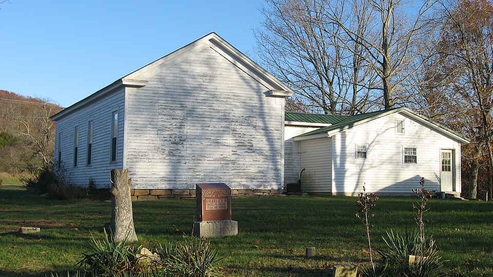
Photograph of Newberry Friends Meeting House
Photograph by Nyttend, Public domain. Via Wikimedia Commons.

Newberry Friends Meeting House

Listed on the National Register of Historic Places in 1996.

From the record

“Newberry Friends Meeting House, now the Friends of Jesus Fellowship Friends Church, is a historic Quaker meeting house and cemetery located in Paoli Township, Orange County, Indiana. It was built in 1856, and is a one-story, rectangular, vernacular Greek Revival style frame building.”

Wikipedia article Newberry Friends Meeting House, CC BY-SA 4.0.

One of 18 National Register listings published here for Orange County · listed in 1996 · category: Building.

Sources: the Wikipedia article · the case file at the National Archives · the National Register database, National Park Service

The listing

  • What is counted as historic. The nomination lists 1 building, 1 site as contributing to the listing.
  • Address. US 150/IN 56 W of Paoli, Paoli, 47454
  • When was it listed? January 1996
  • Category. building
  • Township. Paoli township
  • Architectural style. Greek Revival architecture
  • National Register reference number. 95001534 - the number the National Park Service assigned this property when it was listed, and the key its nomination file is catalogued under at the National Archives.

Fires near this property

16 since 1999

Regional context, not property-specific evidence. The federal wildfire occurrence database lists 16 fires within 5 miles of Newberry Friends Meeting House between 1999 and 2012, burning about 42 acres in total. None started naturally. None was recorded as arson. Distance is straight-line from the map coordinates, so a fire counted here may appear on a neighbouring settlement's page as well.

Reported cause Fires
Debris and open burning11
Missing data/not specified/undetermined2
Smoking2
Equipment and vehicle use1

The most recent of them, most recent first, with the day each was reported and the service that recorded it.

DateCause SizeReported by Name on the report
16 September 2007Debris and open burning1.0 acresHoosier National ForestSPRINGS FIRE
6 July 2012Smoking1.0 acresHoosier National Forest270 WEST
9 April 2001Debris and open burning1.0 acresHoosier National ForestMULZER
2 April 2002Debris and open burning1.0 acresHoosier National ForestAIRPORT
11 March 2001Debris and open burning6.0 acresHoosier National ForestWEST BADEN BARREL
11 March 2001Debris and open burning8.0 acresHoosier National ForestYOUNG'S CREEK
28 February 2006Equipment and vehicle useunder an acreHoosier National ForestORANGE FIRE
19 February 2011Debris and open burning6.0 acresHoosier National ForestTAN DOG

Every fire recorded in Orange County

Mines and quarries near this property

2 within 5 miles

Regional context, not property-specific evidence. The federal mineral resources record lists 2 workings within 5 miles of Newberry Friends Meeting House: 2 producers. All of them still produce. What was taken out: Stone, Crushed/Broken. Distance is straight-line from the map coordinates, so a quarry counted here may appear on a neighbouring settlement's page as well.

Where SiteCommodity StatusRecorded
Calcar QuarryStone, Crushed/BrokenProducer
Cave Quarries, Inc.Stone, Crushed/BrokenProducer

Every working recorded in Orange County

Storms near this property

51 since 1996

Regional context, not property-specific evidence. The National Weather Service names Paoli, the town this property stands in, in 51 storm reports between 1996 and 2023: 28 thunderstorm wind, 15 hail, 4 flash flood, 3 tornado. No death or injury is recorded in these reports. Each account below is quoted exactly as the forecast office filed it, from the NOAA Storm Events Database, and each date opens the federal record of that event.

WhenEvent Place namedHarm What the report says
May 2004Flash FloodPaoli$250,000There was extensive flooding of a residential area in the northern part of Paoli. The worst flooding was on Charles Street and Autumn Drive. Two homes were swept off their foundations by flowing waters. Several residents in the area had to be evacuated by boat.
November 2011Tornado (EF1)Paoli$100,000A tornado first touched down on the north side of the Paoli school complex three quarters of a mile west of the downtown square. It destroyed a 100 year old barn and heavily damaged the roofs of two other outbuildings. It then removed a large section of roofing from the Paoli police department on West Main Street before snapping several trees along Lick Creek. Based on a damage survey, this tornado was classified as an EF-1 with peak winds from 95 to 100 mph between its initial touchdown and the Paoli town square. While moving across the town square, this tornado ripped the metal roofs off of two businesses. Three chimneys on the Orange County Courthouse collapsed. Moving east of the town square, the tornado traveled another mile and a quarter, weakening to EF-0 status while uprooting many trees and damaging the roofs of several homes. Before lifting next to North Marshall Road, the tornado damaged a metal outbuilding.
April 2006Thunderstorm WindPaoli$100,000Several homes sustained major roof damage. A new modular home was blown off its foundation. Trees and power lines were downed in the area. A storm spotter estimated a 100 MPH wind gust.
August 2018Thunderstorm WindPaoli$30,000Multiple trees were reported down on the western side of Paoli. There were also several power outages.
June 2018Thunderstorm WindPaoli$15,000State officials reported power lines down on Water Street in Paoli.
March 2023Thunderstorm WindPaoli-Trees were blown down along State Route 37 near Paoli in addition to other locations across the county.
August 2023Tornado (EF1)Paoli-The first damage point had a few topped and twisted trees near Red Bud Lane and Hospital Rd. Wind speeds were between 75 and 80 mph with a 50 yard width. There was sporadic tree damage along a creek, and tree damage became more concentrated along Apache and Slaten Drive with trees twisted, topped, and one uprooted tree. Wind speeds increased to 85 to 90 mph with a width of 75 yards. The width increased to 100 yards along Sandy Hook Road and Paul Street with wind speeds around 90 mph. There were several trees on homes, and increased twisting of the trees with damage going from the east southeast to the north northeast. There were numerous power poles and powerlines down between Indiana 37 and Paul Street.||The peak of the tornado damage was on the east side of Indiana 37 between Locust Street and Oak Street. Several warehouses had significant roof damage with debris thrown from east southeast to north northeast. There were several cars that had debris on the west and east side of them. The debris from the warehouse was thrown into a forested area up to 200 yards in distance. Wind speed in this area were 100 mph with a width of 110 yards. The NWS drone was key to the survey, with drone imagery capturing trees snapped, topped, and uprooted several hundred yards east of the last warehouse. There was a lot of straight line wind damage between the two different tornadoes in Paoli.
August 2023Tornado (EF0)Paoli-There was plenty of straight-line tree damage from just south of the courthouse in Paoli all the way to the Pioneer Mothers Park of Hoosier National Forest. Across from the park (west side of Indiana Hwy 37) at a residence, there were many trees and large limbs down from straight-line winds (west to the east direction) of 65 mph on the south side of the property and further south on Indiana Hwy 37.||However on the north side of the property, cedar trees were twisted and debris thrown to a north-northeasterly direction. A sycamore tree was snapped with debris going from the east-northeast all the way to a northerly direction.||The survey team spoke to hikers attempting to hike down the Pioneer Mothers Park trail and it was impassable due to trees uprooted, twisted, snapped and topped. The hikers showed pictures of the dozens and dozens of snapped and uprooted trees going from the east- northeast to the north-northeast direction. This EF0 tornado had max wind speeds of 85 mph with a width of 60 yards wide.||The NWS Drone was key to the survey, with drone imagery capturing trees snapped, topped, and uprooted well into the forest. The drone was flown to a large quarry near Highway 150 with all tree damage all facing west to east direction.
July 2020Thunderstorm WindPaoli-There were trees down near Paoli.
October 2019Thunderstorm WindPaoli-Multiple trees across the county were brought down due to high winds, but power and property were not affected.
June 2019Thunderstorm WindPaoli-Numerous trees were reported down across Orange County.
June 2019Thunderstorm WindPaoli-Trees were reported down in Paoli, Indiana.
May 2018Thunderstorm WindPaoli-There was a tree down on South State Road 37 approximately one mile south of Paoli, Indiana.
November 2017Thunderstorm WindPaoli-The Orange County emergency manager reported trees down in Paoli.
February 2016Heavy RainPaoli-A public weather station measured 2.15 inches of rain, most of which fell within a couple hours.
May 2015HailPaoli-A broadcast media meteorologist relayed a report of dime size hail in Paoli.
April 2015Thunderstorm WindPaoli-A trained spotter measured a 56 knot wind gust.
July 2015Flash FloodPaoli-An Orange County law enforcement official reported that Highway 150 between French Lick and Paoli was flooded in spots. Around 2 inches of rain fell in the area from slow moving thunderstorms.
July 2015Flash FloodPaoli-A law enforcement official reported that SR56 west of Paoli was closed due to high water flowing over it. Around 2 inches of rain fell from slow moving thunderstorms.
April 2014Flash FloodPaoli-Lick Creek, in Paoli, overflowed it banks and brought flooding to State Road 37.
April 2013HailPaoli-One inch hail was reported at Paoli High School.
April 2013HailPaoli-A spotter reported 1 inch hail just east of Paoli.
April 2013HailPaoli-A spotter reported 1.75 inch hail in Paoli.
September 2012Thunderstorm WindPaoli-Several trees fell along State Road 37 South.
April 2011Thunderstorm WindPaoli-A trained spotter reported a measured gust of 60 mph.
March 2011Thunderstorm WindPaoli-A tree was blown down on 175W southwest of Paoli.
March 2006Thunderstorm WindPaoli-Law enforcement estimated a 60 mph wind gust. Large tree limbs were downed on State Highway 156 between Paoli and French Lick.
May 2004Thunderstorm WindPaoli-Numerous trees were downed.
May 2004Thunderstorm WindPaoli-Trees and power lines were downed.
July 2004Thunderstorm WindPaoli-Trees were downed.
July 2004Thunderstorm WindPaoli-Several trees were blown down.
February 1999Thunderstorm WindPaoli-Power pole down
February 1999HailPaoli-One inch hail fell in Paoli
May 2011HailPaoli-no account filed
May 2009HailPaoli-no account filed
April 2006HailPaoli-no account filed
July 2004HailPaoli-no account filed
May 2003HailPaoli-no account filed
June 2002HailPaoli-no account filed
July 2001Thunderstorm WindPaoli-no account filed
October 2001Thunderstorm WindPaoli-no account filed
May 2000Thunderstorm WindPaoli-no account filed
November 2000Thunderstorm WindPaoli-no account filed
June 1998Thunderstorm WindPaoli-no account filed
April 1998HailPaoli-no account filed
May 1998Thunderstorm WindPaoli-no account filed
May 1998HailPaoli-no account filed
April 1997Thunderstorm WindPaoli-no account filed
May 1996Thunderstorm WindPaoli-no account filed

Every storm recorded in Orange County

Map coverage status

No historic map-sheet match is published for this property yet. That does not mean no map exists. This record needs a coordinate-quality review before it can be joined to a sheet boundary. Browse the county's mapped places while that work is pending.

Listed places nearby

6 within 8 miles

Other National Register properties close enough to walk or drive between, ordered by distance from this one. Both positions come from the same geocoding pass that matched these properties to their map sheets.

Photograph PropertyDistance Listed
Thomas Elwood Lindley House1.0 miles1985
Paoli Historic District1.8 miles1994
Thomas Newby Braxtan House1.8 miles1989
Orange County Courthouse1.9 miles1975
The Maples Farm3.6 miles2026
First Baptist Church6.0 miles1994

Sources for this property

National Archives recordThe nomination case file for reference 95001534 in Record Group 79.
Wikipedia articleCommunity-written account of this property, licensed CC BY-SA.
Orange CountyAll 18 listed properties in this county.

Provenance

  • Listing record. National Park Service National Register of Historic Places, listed-properties dataset, current to 2026-05-22.
  • Map join. Address geocoded through the United States Census geocoder, then tested against the published boundary of every sheet in the USGS Historical Topographic Map Collection.
  • How this page is made. Listing fields come from federal records; map-sheet coverage is a labelled coordinate-to-boundary calculation, not a source-field claim.
  • Wildfire. Short, Karen C. 2022. Spatial wildfire occurrence data for the United States, 1992-2020 [FPA_FOD_20221014]. 6th Edition. Fort Collins, CO: Forest Service Research Data Archive. https://doi.org/10.2737/RDS-2013-0009.6 Collected with United States Government funding and usable without additional permissions or fees.
  • Mines and quarries. USGS Mineral Resources Data System (MRDS) https://mrdata.usgs.gov/mrds/ A work of the United States government, no copyright under 17 U.S.C. 105.
  • Storms. NOAA National Centers for Environmental Information, Storm Events Database https://www.ncei.noaa.gov/stormevents/ A work of the United States government, no copyright under 17 U.S.C. 105. Narratives are quoted verbatim from the National Weather Service report and are not edited or summarised.