 Block
From the record
10 National Register listings published here.
Sources: the county history on the Internet Archive · the National Register database, National Park Service
32 topographic sheets cover 15 settlements here, and 10 properties are on the National Register of Historic Places.
10 National Register listings published here.
Sources: the county history on the Internet Archive · the National Register database, National Park Service
Every property in this county listed on the National Register of Historic Places, with the year it was listed and the federal nomination document.
| Photograph | Property | Type | Listed | Reference |
|---|---|---|---|---|
| Chicago and Erie Railroad Tippecanoe River Bridge | structure | 2022 | 100007738 | |
| Francesville Commercial Historic District | district | 2025 | 100012176 | |
 | Mallon Building | building | 1999 | 99001151 |
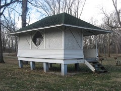 | Monterey Bandstand | building | 2012 | 12000339 |
 | Pulaski County Bridge No.31 | structure | 03000546 | |
 | Pulaski County Courthouse | building | 2007 | 07001282 |
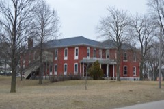 | Pulaski County Home | building | 2015 | 15000079 |
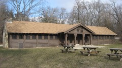 | Tepicon Hall | building | 1992 | 92000189 |
 | Dr. George W. Thompson House | building | 1984 | 84001233 |
 | Vurpillat's Opera House | building | 2002 | 02000201 |
The NOAA Storm Events Database holds 152 reports for this county, causing no deaths, 13 injuries and about $4,767,250 in recorded property damage. Each settlement page carries the reports that name it.
| Kind of event | Reports |
|---|---|
| Thunderstorm Wind | 81 |
| Hail | 50 |
| Tornado | 17 |
| Flash Flood | 3 |
| Flood | 1 |
The most serious of them, by death, then injury, then recorded damage. The accounts are quoted exactly as the forecast office filed them.
| When | Event | Place named | Harm | What the report says |
|---|---|---|---|---|
| April 1974 | Tornado (F4) | not stated | 7 hurt | no account filed |
| June 1951 | Tornado (F3) | not stated | 2 hurt, $2,500,000 | no account filed |
| April 1963 | Tornado (F4) | not stated | 2 hurt | no account filed |
| June 1998 | Tornado (F2) | Ripley | 1 hurt, $1,000,000 | 4 TRAILER HOMES DESTROYED, SEVERAL OTHERS SUFFERED MINOR TO MAJOR DAMAGE, ONE HOME AND BARN DESTROYED, SEVERAL OTHER HOMES SUFFERED MODERATE DAMAGE. TORNADO STARTED IN RIPLEY AND TRACKED EAST NORTHEAST TO MONTEREY BEFORE IT LIFTED. EXTENSIVE TREE DAMAGE OCCURRED ALONG THE TORNADOES PATH. |
| September 1971 | Tornado (F1) | not stated | 1 hurt, $2,500 | no account filed |
| April 1994 | Tornado (F2) | Francesville | $500,000 | The tornado touched down near Francesville in southwest Pulaski County then tracked northeast across the entire county entering extreme northeast Fulton county 1.1 miles northeast of Monterey at 2313 EST. It then crossed into extreme southwest Marshall county 3.7 miles southwest of Culver at 2315 EST and lifted at 2321 EST about 2.5 miles southeast of Culver. The tornado destroyed five farm buildings, and damaged numerous others. One home was destroyed. A mobile home was lifted off the ground and placed on top of a car. Dozens of large trees were uprooted at Tippecanoe River State Park north of Winamac. The tornado damage path was intermittent. |
| June 1973 | Tornado (F1) | not stated | $250,000 | no account filed |
| June 1970 | Tornado (F1) | not stated | $250,000 | no account filed |
| July 2022 | Thunderstorm Wind | Star City | $40,000 | A roof came off a house. Damage to another house from fallen trees. Crop damage in numerous locations. |
| February 2018 | Flood | Monterey | $38,000 | Extensive river basin flooding occurred across the county with several roads having to be closed at times as the Tippecanoe River went well out of its banks to near record levels. Damage was reported to many roads with some suffering partial washouts as drainage was unable to keep up with the water flow. Preliminary damage estimates were around 38,000 dollars. |
| June 2007 | Thunderstorm Wind | Winamac | $30,000 | Numerous reports of trees and power lines down were received across the county. |
| August 1991 | Tornado (F0) | not stated | $25,000 | no account filed |
| March 2025 | Thunderstorm Wind | Star City | $20,000 | Structural damage to a barn at 2450 E 475 S. Roof and siding blown off and strewn across the road and field. Large limbs also down. |
| October 2008 | Thunderstorm Wind | Monterey | $20,000 | The Monterey Fire Department reported several trees uprooted, with a few landing onto houses. Also power lines were reported down across the area. |
| May 2007 | Thunderstorm Wind | Medaryville | $15,000 | A semi was flipped over near the interesection of US-421 and State Route 14. |
| December 2008 | Thunderstorm Wind | Medaryville | $10,000 | Law enforcement officials reported power lines down as well as some building damage in Medaryville. |
| October 2007 | Hail | Denham | $10,000 | Golf ball hail significantly damaged a car. Damage is estimated at around $10,000. |
| August 2001 | Thunderstorm Wind | Winamac | $10,000 | Grain elevator damaged. |
| May 2000 | Thunderstorm Wind | Winamac | $10,000 | Trees down. Large limbs on cars. Minor roof damage to church. |
| November 1998 | Thunderstorm Wind | Countywide | $10,000 | NUMEROUS TREES AND POWER LINES BLOWN DOWN ACROSS THE COUNTY. |
| August 2022 | Thunderstorm Wind | Winamac Arens Fld Ar | $5,000 | A large tree is down. |
| June 2008 | Thunderstorm Wind | Denham | $5,000 | County officials reported power lines down west of Denham. |
| June 2008 | Thunderstorm Wind | Denham | $5,000 | County officials reported power lines down west of Denham. |
| December 2006 | Thunderstorm Wind | Winamac | $3,000 | A few trees were blown down. One tree limb was blown down onto a car. A carport was blown off of a house and a dog kennel blown across a yard. Damage is estimated at $3,000. |
| April 1975 | Tornado (F0) | not stated | $2,500 | no account filed |
| April 1960 | Tornado | not stated | $2,500 | no account filed |
| July 2024 | Thunderstorm Wind | Winamac | $1,000 | Large tree down blocking E Hutchinson Rd. |
| June 1995 | Thunderstorm Wind | Winimac | $1,000 | Trees were blown down. |
| August 1994 | Thunderstorm Wind | not stated | $1,000 | no account filed |
| March 2023 | Hail | Francesville | $500 | A report on mPING indicated half-inch hail. |
| June 1954 | Tornado (F1) | not stated | $250 | no account filed |
| March 2022 | Thunderstorm Wind | Star City | - | Local electrical crews reported five broken power poles. Diameter was not known. |
| August 2021 | Thunderstorm Wind | Winamac | - | Reported from MPing. |
| August 2021 | Thunderstorm Wind | Winamac | - | Trees down on 12th and Market St. in Winamac. |
| July 2019 | Thunderstorm Wind | Monterey | - | Local media reported multiple trees were blown down or uprooted on CR 500 N. |
| July 2017 | Thunderstorm Wind | Ripley | - | A local fire department reported a tree limb was blown down onto a power line, causing it to fall and the power line to smoke. |
| November 2016 | Thunderstorm Wind | Winamac | - | The public reported a 30 foot tall, seven inch diameter healthy tree was snapped in half. |
| November 2016 | Thunderstorm Wind | Lawton | - | The public reported a portion of a center pivot irrigation system being rolled over. |
| June 2015 | Thunderstorm Wind | Medaryville | - | Reports of trees snapped and uprooted. Health and size of trees undefined. |
| June 2015 | Thunderstorm Wind | Beardstown | - | Trees and limbs down in broken arrow campground. |
| June 2015 | Thunderstorm Wind | Medaryville | - | Several 8-12 inch tree limbs down. |
| September 2015 | Thunderstorm Wind | Winamac | - | The public reported several branches as well as a few small trees blown down. |
| June 2014 | Thunderstorm Wind | Winamac | - | Law enforcement officials reported numerous trees down across northern parts of the county, especially north of Winamac. |
| August 2014 | Thunderstorm Wind | Pulaski | - | A trained spotter reported a 14 inch diameter tree was blown down. |
| June 2013 | Hail | Medaryville | - | The public reported golf ball size hail at the intersection of State Routes 39 and 14. |
| June 2013 | Hail | Winamac | - | Emergency management officials reported golf ball size hail near Winamac. |
| June 2013 | Hail | Winamac | - | A trained spotter reported golf ball sized hail, which lasted for around two minutes. There was some minor damage to vehicles in the area. |
| June 2013 | Hail | Lawton | - | Pictures of hen egg size hail was posted on a Facebook page. Comments indicated hail from the size of quarters to hen eggs fell for five minutes. |
| June 2013 | Flash Flood | Medaryville | - | Law enforcement officials reported numerous roads with water on them. Countless reports of stranded cars in flood waters were received by dispatch. |
| November 2013 | Tornado (EF1) | Medaryville | - | A survey of damage in northern Pulaski county by emergency management and NWS officials revealed damage consistent with a EF1 tornado. The tornado touched down just southwest of U.S. 421 and Delaware Street in Medaryville. Several large, healthy trees suffered damage ranging from broken limbs to trees being snapped at the base (DI: TS DOD: 4). The tornado exited the town and remained over mainly rural areas moving across harvested fields and occasionally impacting groves of trees or center pivot irrigation systems. A barn was completely destroyed (DI: SBO DOD: 8) on North County Road 1050 West. The tornado entered the town of Denham impacting a grain bin, which was moved off its foundation and then flattened. The tornado cause minor tree damage and then lifted just before crossing into Starke county. The maximum wind speed is estimated at 110 mph.. |
| November 2013 | Thunderstorm Wind | Denham | - | The public reported multiple center pivots being flipped. |
| June 2012 | Thunderstorm Wind | Denham | - | Law enforcement officials reported trees and power lines down around Denham. |
| June 2012 | Thunderstorm Wind | Ripley | - | Law enforcement officials reported numerous trees and power lines down across the northern parts of the county. |
| July 2012 | Thunderstorm Wind | Winamac | - | A trained spotter estimated wind gusts to 70 mph. Several two to four inch diameter branches were blown down in the area. |
| July 2012 | Thunderstorm Wind | Medaryville | - | The highway department reported several trees were blown down, blocking State Route 143, between U.S 421 and Medaryville. |
| June 2011 | Thunderstorm Wind | Denham | - | Local media outlets relayed trees were blown down in the northern portion of the county near the Starke and Pulaski county line. |
| May 2011 | Hail | Francesville | - | An intense storm allowed for hail to fall for around 15 minutes. The hail varied in size, with the largest stone up to the size of golf balls. |
| May 2011 | Tornado (EF0) | Francesville | - | A survey of damage in the Francesville area found indications of a brief circulation touchdown. The circulation touched down just west of U.S. 421 and tracked quickly east northeast across 421, knocking over five power poles. A pole barn was destroyed near the intersection of Bill and James Street with trees blown down in the 400 block of East Montgomery. The width of the tornado was no more than 50 yards with maximum winds estimated between 80 and 85 mph. |
| May 2011 | Thunderstorm Wind | Francesville | - | Law enforcement officials reported power poles down on U.S. 421 near Francesville. In addition numerous trees were blown down across the county. |
| June 2010 | Thunderstorm Wind | Monterey | - | Trained spotter estimated 70 mph winds with nickel sized hail. |
The Survey's mineral resources record lists 5 workings inside this county. 3 still produce and 2 are closed or unrecorded. Each settlement page carries the workings within five miles of it.
| Commodity | Workings |
|---|---|
| Calcium | 1 |
| Sand and Gravel, Construction | 1 |
| Stone, Crushed/Broken | 1 |
| Clay | 1 |
| Stone | 1 |
The least common of them first, because a county's hundredth gravel pit says nothing its first ten did not.
| Where | Site | Commodity | Status | Recorded |
|---|---|---|---|---|
| Francesville Clay Pit | Clay | Past Producer | ||
| Francesville Stone Quarry | Stone, Crushed/Broken | Producer | ||
| Pulaski Co. Hwy. Dept. | Stone | Producer | ||
| Roth Pit | Sand and Gravel, Construction | Past Producer | ||
| Ward Stone Company | Calcium | Producer |
Named settlements recorded in the Geographic Names Information System, each with the topographic sheets covering it. Villages, hamlets and abandoned places alike. Each is shown with the nearest named watercourse or landform and the survey quadrangle it falls on.
Van Buren township · 46985 · On Grassy Creek · Star City quadrangle
8 sheets, 1953 to 1985
Tippecanoe township · 46996 · Near Bunker Hill · Winamac quadrangle
10 sheets, 1953 to 1984