 Block
From the record
One of 10 National Register listings published here for Pulaski County · listed in 2025 · category: District.
Sources: the National Register database, National Park Service
Listed on the National Register of Historic Places in 2025.
One of 10 National Register listings published here for Pulaski County · listed in 2025 · category: District.
Sources: the National Register database, National Park Service
Regional context, not property-specific evidence. The federal mineral resources record lists 3 workings within 5 miles of Francesville Commercial Historic District: 2 producers, 1 past producer. 2 still produce. What was taken out: Calcium, Stone, Crushed/Broken, Clay. Distance is straight-line from the map coordinates, so a quarry counted here may appear on a neighbouring settlement's page as well.
| Where | Site | Commodity | Status | Recorded |
|---|---|---|---|---|
| Francesville Clay Pit | Clay | Past Producer | ||
| Francesville Stone Quarry | Stone, Crushed/Broken | Producer | ||
| Ward Stone Company | Calcium | Producer |
Regional context, not property-specific evidence. The National Weather Service names Francesville, the town this property stands in, in 15 storm reports between 1994 and 2023: 10 hail, 3 tornado, 2 thunderstorm wind. No death or injury is recorded in these reports. Each account below is quoted exactly as the forecast office filed it, from the NOAA Storm Events Database, and each date opens the federal record of that event.
| When | Event | Place named | Harm | What the report says |
|---|---|---|---|---|
| April 1994 | Tornado (F2) | Francesville | $500,000 | The tornado touched down near Francesville in southwest Pulaski County then tracked northeast across the entire county entering extreme northeast Fulton county 1.1 miles northeast of Monterey at 2313 EST. It then crossed into extreme southwest Marshall county 3.7 miles southwest of Culver at 2315 EST and lifted at 2321 EST about 2.5 miles southeast of Culver. The tornado destroyed five farm buildings, and damaged numerous others. One home was destroyed. A mobile home was lifted off the ground and placed on top of a car. Dozens of large trees were uprooted at Tippecanoe River State Park north of Winamac. The tornado damage path was intermittent. |
| March 2023 | Hail | Francesville | $500 | A report on mPING indicated half-inch hail. |
| May 2011 | Hail | Francesville | - | An intense storm allowed for hail to fall for around 15 minutes. The hail varied in size, with the largest stone up to the size of golf balls. |
| May 2011 | Tornado (EF0) | Francesville | - | A survey of damage in the Francesville area found indications of a brief circulation touchdown. The circulation touched down just west of U.S. 421 and tracked quickly east northeast across 421, knocking over five power poles. A pole barn was destroyed near the intersection of Bill and James Street with trees blown down in the 400 block of East Montgomery. The width of the tornado was no more than 50 yards with maximum winds estimated between 80 and 85 mph. |
| May 2011 | Thunderstorm Wind | Francesville | - | Law enforcement officials reported power poles down on U.S. 421 near Francesville. In addition numerous trees were blown down across the county. |
| June 2008 | Hail | Francesville | - | Law enforcement officials and spotters report hail as large as tennis balls falling from the storm in the Francesville area. As the storm moved rapidly northeast towards Winamac, hail continued to fall but slowly decreased in size with golf ball size hail reported southwest of Winamac and then quarter size hail being reported in Winamac. One more round of hail slightly larger than golf balls was reported southwest of Monterey before the storm moved into Marshall County. |
| June 2006 | Hail | Francesville | - | Hail damage to crops |
| July 2003 | Thunderstorm Wind | Francesville | - | Law enforcement reported trees and power lines down. |
| July 2001 | Tornado (F0) | Francesville | - | Tornado crossed into Pulaski county from Jasper county and traveled for about one mile beforelifting. Funnel cloud was visible for another 15 minutes before dissipating near the Pulaski and Whitecounty line. Tornado was down in corn field. |
| June 2019 | Hail | Francesville | - | no account filed |
| March 2012 | Hail | Francesville | - | no account filed |
| August 2004 | Hail | Francesville | - | no account filed |
| May 2001 | Hail | Francesville | - | no account filed |
| July 1994 | Hail | Francesville | - | no account filed |
| July 1994 | Hail | Francesville | - | no account filed |
No historic map-sheet match is published for this property yet. That does not mean no map exists. This record needs a coordinate-quality review before it can be joined to a sheet boundary. Browse the county's mapped places while that work is pending.
Other National Register properties close enough to walk or drive between, ordered by distance from this one. Both positions come from the same geocoding pass that matched these properties to their map sheets.
| Photograph | Property | Distance | Listed |
|---|---|---|---|
 | Mallon Building | under 500 feet | 1999 |
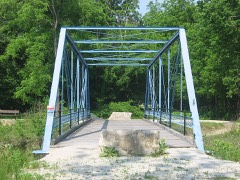 | Pulaski County Bridge No.31 | 5.8 miles |
| National Archives record | The nomination case file for reference 100012176 in Record Group 79. |
| Pulaski County | All 10 listed properties in this county. |