 Block
From the record
3 National Register listings published here.
Sources: the National Register database, National Park Service
38 topographic sheets cover 19 settlements here, and 3 properties are on the National Register of Historic Places.
3 National Register listings published here.
Sources: the National Register database, National Park Service
Every property in this county listed on the National Register of Historic Places, with the year it was listed and the federal nomination document.
| Photograph | Property | Type | Listed | Reference |
|---|---|---|---|---|
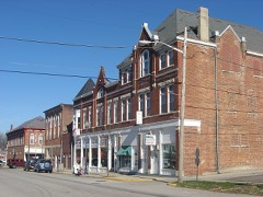 | Liberty Courthouse Square Historic District | district | 2013 | 13001018 |
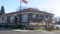 | Liberty Residential Historic District | district | 2013 | 13001017 |
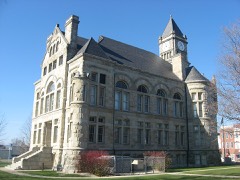 | Union County Courthouse | building | 1987 | 87000103 |
The NOAA Storm Events Database holds 146 reports for this county, causing 2 deaths, 9 injuries and about $3,644,750 in recorded property damage. Each settlement page carries the reports that name it.
| Kind of event | Reports |
|---|---|
| Thunderstorm Wind | 80 |
| Hail | 27 |
| Flash Flood | 22 |
| Flood | 13 |
| Tornado | 3 |
| Heavy Rain | 1 |
The most serious of them, by death, then injury, then recorded damage. The accounts are quoted exactly as the forecast office filed them.
| When | Event | Place named | Harm | What the report says |
|---|---|---|---|---|
| July 1998 | Thunderstorm Wind | Liberty | 2 killed, 6 hurt, $25,000 | Numerous trees downed across the county, one of which fell across a tent, injuring six campers. Also, two people were killed when a boat overturned in the storm on Brookville Lake. |
| July 2023 | Thunderstorm Wind | Liberty | 3 hurt, $10,000 | Several trees were downed in and around Whitewater Memorial State Park. One tree fell onto a tent, resulting in 3 non-life threatening injuries. |
| November 1992 | Tornado (F2) | not stated | $2,500,000 | no account filed |
| March 1955 | Tornado (F2) | not stated | $250,000 | no account filed |
| June 2003 | Flash Flood | Liberty | $100,000 | State Route 101 was underwater near town, with several other roads in town closed by high water. The Union County Public Library and Edwards Memorial United Methodist Church both sustained basement flooding. |
| May 2011 | Thunderstorm Wind | Liberty | $65,000 | Large trees were reported down with one of them down on a house due to damaging thunderstorm winds. Sheds were tipped over, a roof was peeled from a garage, a barn roof was peeled off with debris strewn for at least a half of a mile, a large grain silo was dented in, and a heavy wagon was rolled in excess of one hundred feet due to the winds. |
| June 2003 | Flash Flood | West College Corner | $50,000 | Numerous roads were underwater in town. Several homes had water on the first floor, and the College Corner Union School sustained minor flood damage. |
| June 1994 | Thunderstorm Wind | Liberty | $50,000 | Thunderstorm winds blew down numerous trees which toppled power lines across the center of the county at Liberty. Some of the trees in Liberty also fell on some homes causing minor damage. |
| May 1994 | Hail | Creston | $50,000 | no account filed |
| May 1994 | Hail | Thayer | $50,000 | no account filed |
| July 2023 | Thunderstorm Wind | Liberty | $35,000 | A business on South State Route 101 received significant roof damage. |
| June 2019 | Tornado (EF1) | Clifton | $35,000 | The tornado first touched down on the 1700 block of North U.S. Route 27, where a swirl was observed in a field just to the southwest of a well-constructed, 110 ft by 105 ft metal farm storage building. Several 4 X 4`s were snapped and the building was completely destroyed. Metal debris from this building was identified over 2 miles to the northeast. Wood debris from the barn was located from south to north in a semicircle approximately two hundred yards wide. In addition, there was a convergent path of wood and metal debris off to the northeast. Along this convergent path, a significant amount of debris was deposited in a tree line approximately a half mile to the northeast.||Additional damage was observed along the 1700 block of East Mitchell Road. An eyewitness saw the tornado a half mile to the southwest, and estimated the width as around 100 feet. He also observed large pieces of metal rotating in the tornado. At his property, an ornamental iron fence was bent down at a 45 degree angle due to a combination of winds associated with the tornado and debris from the location on North U.S. Route 27. The home also suffered some damage, including glass from a storm door blown in and broken glass from four windows. A circular item around three|feet in diameter and weighing two hundred pounds was lifted up, hit the house and then deposited about a couple hundred feet in a ditch behind the house. Numerous trees and large limbs across the property were also knocked down. A few of the trees reached diameters up to two feet.||Debris was evident in the field northeast of the East Mitchell Road residence. This debris was associated with the large metal building at the first location.||Additional damage was found further northeast at a residence on County Road 200 East. Several trees were downed, with one falling on the roof of a house and causing damage. This is the last known damage that occurred from this tornado. |
| July 2015 | Flash Flood | College Corner | $25,000 | The west fork of Four Mile Run came out of its banks and was flowing over Brookville Pike Road. A part of the road was washed away. In addition, trees were downed due to the flash flooding and a car was trapped in the water. |
| February 2008 | Thunderstorm Wind | Liberty | $25,000 | A structure on Salem Road south of US Route 27 sustained minor damage, including having its windows blown out. A roof was blown off a house east of Liberty along State Route 44. A hog barn was blown off its foundation and numerous trees were knocked down. |
| July 2000 | Flash Flood | Liberty | $25,000 | Heavy rainfall caused flooding, which washed a road out. |
| April 2018 | Flash Flood | Brownsville | $20,000 | Brownsville Road was flooded and potentially washed out. |
| April 2020 | Thunderstorm Wind | Dunlapsville | $15,000 | Several trees were snapped and a barn sustained some roof damage. Also, a picnic table was picked up and thrown northeast of its original position. A rowboat was picked up and dropped across a field. Finally, a dock was lifted and torn out and boards were thrown across the pond up in a tree. |
| August 2000 | Thunderstorm Wind | Countywide | $10,000 | Thunderstorm winds knocked down numerous trees, especially in Liberty. |
| February 1999 | Thunderstorm Wind | Clifton | $10,000 | Storms damaged a residence and a shed, and knocked down trees. |
| July 1998 | Thunderstorm Wind | Countywide | $10,000 | Trees downed across the county. |
| November 1996 | Thunderstorm Wind | Liberty | $10,000 | no account filed |
| February 2017 | Thunderstorm Wind | Cottage Grove | $9,000 | Seven power poles were knocked down near the intersection of South Liberty Pike Road and East Retherford Road. |
| May 2008 | Thunderstorm Wind | Brownsville | $8,000 | Several trees were downed across the county. |
| June 2008 | Hail | Liberty | $8,000 | Trees were also knocked down near Cottage Grove. |
| June 2006 | Thunderstorm Wind | Countywide | $8,000 | Large tree limbs were downed. |
| June 2006 | Thunderstorm Wind | Countywide | $8,000 | Trees and large limbs were downed. |
| July 2003 | Thunderstorm Wind | West College Corner | $8,000 | A tree fell on a shelter house at a ball park, causing minor damage. A few other trees and powerlines were downed in town. |
| April 2003 | Thunderstorm Wind | Witts Station | $8,000 | A barn was destroyed. |
| June 2016 | Thunderstorm Wind | Clifton | $7,000 | Six to seven electric poles in a row were snapped in half or tilted. |
| July 2002 | Thunderstorm Wind | Countywide | $6,000 | Trees were knocked down. |
| May 2022 | Thunderstorm Wind | Lotus | $5,000 | A few telephone poles were downed on South Liberty Pike. |
| April 2017 | Thunderstorm Wind | College Corner | $5,000 | A porch was blown off of a residence. Also, the roof was peeled off over the doorway. |
| May 2014 | Thunderstorm Wind | Brownsville | $5,000 | Several trees and utility lines were downed in the Brownsville and Clifton areas due to thunderstorm winds. |
| June 2012 | Thunderstorm Wind | Dunlapsville | $5,000 | Numerous trees were downed in Whitewater Memorial State Park due to thunderstorm winds. |
| March 2011 | Flood | Abington | $5,000 | Several roads were flooded due to heavy rainfall. |
| March 2008 | Flood | Dunlapsville | $5,000 | Numerous roads flooded, including Brownsville Road in Yankeetown and State Route 44 at Nine Mile Bridge. |
| June 2006 | Thunderstorm Wind | West College Corner | $5,000 | Several trees and large limbs were knocked down. |
| June 2001 | Flash Flood | Countywide | $5,000 | High water on roadways |
| April 2000 | Thunderstorm Wind | Liberty | $5,000 | Numerous trees downed. |
| August 2000 | Thunderstorm Wind | Countywide | $5,000 | Numerous trees knocked down across the county, especially in the northern part. |
| November 2000 | Thunderstorm Wind | Witts Station | $5,000 | Trees were knocked down by thunderstorm winds. |
| September 2000 | Thunderstorm Wind | Countywide | $5,000 | Trees knocked down in several locations across the county. |
| August 2000 | Thunderstorm Wind | Countywide | $5,000 | Numerous trees downed across the county. |
| May 1999 | Thunderstorm Wind | Countywide | $5,000 | Several trees were down countywide. |
| June 1998 | Thunderstorm Wind | Liberty | $5,000 | Many trees downed by thunderstorm winds. |
| July 1998 | Flash Flood | Countywide | $5,000 | Heavy rainfall caused several county roads to be covered by water. |
| July 1998 | Thunderstorm Wind | Countywide | $5,000 | Trees downed. |
| June 1998 | Flash Flood | Countywide | $5,000 | Heavy rainfall caused several roads to be closed. |
| June 1997 | Flash Flood | Countywide | $5,000 | Heavy rainfall caused several roads to be closed as area creeks and streams rose. |
| April 1994 | Thunderstorm Wind | Liberty | $5,000 | Numerous trees and power lines were downed by high winds in Liberty. Fayette County Connersville,27,0250EST,,,0,0,?,0,Thunderstorm Winds Several trees and power lines were blown down near Connersville. |
| March 1997 | Hail | Liberty | $5,000 | no account filed |
| July 1996 | Thunderstorm Wind | Billingsville | $5,000 | no account filed |
| May 2022 | Thunderstorm Wind | Liberty | $4,000 | A few trees were downed. |
| July 2017 | Thunderstorm Wind | Liberty | $4,000 | Several trees were downed in the Liberty area. |
| June 1995 | Thunderstorm Wind | Brownsville | $4,000 | Trees were downed. |
| May 2020 | Thunderstorm Wind | Kitchell | $3,000 | A few trees were downed on Kitchel Road. |
| July 2012 | Thunderstorm Wind | Brownsville | $3,000 | Several trees were downed due to damaging thunderstorm winds. |
| July 2006 | Thunderstorm Wind | Liberty | $3,000 | Trees were knocked down. |
| May 2005 | Thunderstorm Wind | Liberty | $3,000 | A few trees were knocked down. |
| June 2005 | Thunderstorm Wind | Liberty | $3,000 | Trees were downed. |
The Survey's mineral resources record lists 2 workings inside this county. All of them still produce. Each settlement page carries the workings within five miles of it.
| Commodity | Workings |
|---|---|
| Sand and Gravel, Construction | 1 |
| Stone | 1 |
The least common of them first, because a county's hundredth gravel pit says nothing its first ten did not.
| Where | Site | Commodity | Status | Recorded |
|---|---|---|---|---|
| Union Co. Hwy. Dept | Stone | Producer | ||
| Union County Materials | Sand and Gravel, Construction | Producer |
Named settlements recorded in the Geographic Names Information System, each with the topographic sheets covering it. Villages, hamlets and abandoned places alike. Each is shown with the nearest named watercourse or landform and the survey quadrangle it falls on.
Brownsville township · 47325 · On Simpson Creek · Brownsville quadrangle
10 sheets, 1953 to 1986
Union township · 47003 · On Brandywine Creek · College Corner quadrangle
16 sheets, 1915 to 1992
Liberty township · 47353 · On Silver Creek · New Fairfield quadrangle
17 sheets, 1915 to 1986
Center township · 47353 · On Goodwins Creek · Fairhaven quadrangle
13 sheets, 1915 to 1986
Brownsville township · 47353 · On Bear Branch · Liberty quadrangle
14 sheets, 1915 to 1986
Liberty township · 47353 · On Salem Branch · New Fairfield quadrangle
17 sheets, 1915 to 1986
Union township · 47003 · On Corner Run · College Corner quadrangle
16 sheets, 1915 to 1992
Harrison township · 47353 · On Witts Run · Fairhaven quadrangle
13 sheets, 1915 to 1986
Brownsville township · 47325 · On Woods Creek · Liberty quadrangle
14 sheets, 1915 to 1986