 Block
Frankton, Indiana
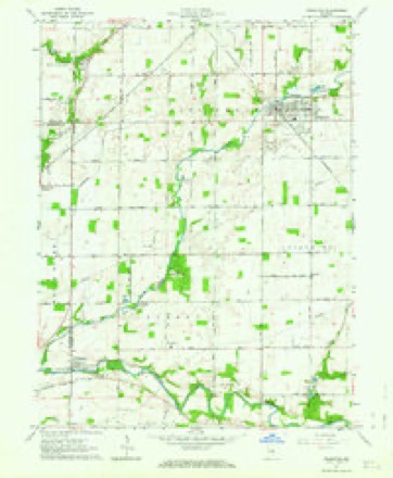
11 topographic sheets cover this place, the earliest surveyed in 1953 and the latest in 1986. It stands in Pipe Creek Township. It lies in ZIP code area 46044. The Survey maps it on the Frankton quadrangle. 1,775 people lived here at the 2020 count. It stands 837 feet above sea level.
Population over time
2 figuresFrankton fell from 1,862 to 1,775 between 2010 and 2020. These are the recorded population figures Wikidata holds for this place, reached through the Geographic Names Information System number this page is keyed on rather than by name, so they belong to this place and not to another of the same name. Most are census counts, but not all are: an early figure may be a founding or settlement estimate, and an estimate published within five years of a census is left out. The change column is computed, and is left blank where more than 20 years separate a figure from the one before it, because a gap that long is not a change between two counts.
| Year | People | Change |
|---|---|---|
| 2010 | 1,862 | |
| 2020 | 1,775 | -87 (-5%) |
Topographic sheets covering this place
4 surveys from 11 printed sheetsMatched by testing this settlement's coordinate against the published boundary of every sheet in the United States Geological Survey's historical collection. Each opens the scanned sheet at the Survey.
- 1953 USGS Muncie quadrangle1:250000, 5 printings
- 1956 USGS Muncie quadrangle1:250000
- 1962 USGS Frankton quadrangle1:24000, 2 printings
- 1986 USGS Muncie quadrangle1:100000, 3 printings



In the county-history sources
1,200 words on this townshipHistory of Madison County, Indiana, from 1820 to 1874 : Giving a General Review of Principal Events, Statistical and Historical Items, Derived from Official Sources, published 1874 names this settlement in its chapter on Pipe Creek Township. These are the passages that mention it, exactly as the scans read.
This township, with the addition of Monroe, occupies the entire width of the county. It contains forty-two square miles, and has nine in-and-out corners. Among its first settlers were Jacob Sigler, Isaac Mills, James Beason, Elijah Dwiggins, William Taylor, Joseph Miller, John Gough, Jacob Siiepherd, Henry Pluraraer, and Joiin Quick. Among the Justices who have served we find the names of James Beeson, Jonathan Reader, Francis Sigler, Henry INIills, Henry McElircsh, Richard Miner, M. Mills, J. M. Doughty, Tremelous Beason, Rudolph Brown, Alexander AVood and John Little. The population, in 1850, was one thousand five hundred and twelve; in 1860 it was one thousand six hundred and ninety ; in 1870 it was two thousand three hundred; in 1874 estimated at two thousand five hundred. In 1870 it contained thirteen thousand five iiundred and forty-six aores of improved land. The value of farms and farm implements was $835,170; value of live stock, $125,442; value of all products, §238,179. The number of bushels of corn in 1870 was one hundred and thirty-four thousand five hundred and forty-seven ; number of school houses, eleven. The total value, including grounds, etc., $11,900. The number of grist mills, three; sawmills, five; post offices, two; blacksmith shops, five; harness shops, two; shoe shops, live; physicians, six; drug stores, four ; dry goods stores, five ; groceries, three ; wagon and carriage shops, one ; local preachers, four ; sabbath schools, six; voting precincts, two; carpenters, [eight ; Granges, five; Masonic Lodges, two; Odd Fellow Lodges, two. Frankton and Elwood are both in this township. Pipe Creek and Duck Creek both pass through the township. The Cincinnati and Chicago Railroad passes through the central part, and the Lafayette and Muucie Railroad, now in progress, passes through the northern part, and is, at this writing, graded and ready for the ties. The first town started in this township was New Madison, and was built iu 1835. Among the first ministers was Rev. Beach, who preached at the house of Jacob Sigler iu 1825. The first school house was built at Frankton ia 1830. The first Sunday school was organized by John Snell in 1832. A sabbath school was organized at Elwood, in 1855, by Joseph Anderson. The New Light Society first met at Hagerty's- School House, in 1859, when there was preaching by J. Depboy. Among the first members of this society were William King and wife, Lewis Bailey and wife, Berry Etchison and wife, S. Hurst and Malinda Etcherson. The first United Brethren Church was organized in 1832, at the house of William Montgomery. Among the first members were William Montgomery and wife. It will be seen by the above figures that Pipe Creek is among the foremost in the county, and its soil will compare favorably with the rest of the townships.
Passage source: History of Madison County, Indiana, from 1820 to 1874 : Giving a General Review of Principal Events, Statistical and Historical Items, Derived from Official Sources, published 1874.
Machine-read from a century-old scan, so expect the errors a machine makes: misspelled names, dropped words, stray characters.
Mines and quarries near this place
1 within 5 milesRegional context, not property-specific evidence. The federal mineral resources record lists 1 working within 5 miles of Frankton: 1 producer. All of them still produce. What was taken out: Sand and Gravel, Construction. Distance is straight-line from the map coordinates, so a quarry counted here may appear on a neighbouring settlement's page as well.
| Where | Site | Commodity | Status | Recorded |
|---|---|---|---|---|
| Ryan, Inc. | Sand and Gravel, Construction | Producer |
Storms near this place
24 since 1995Regional context, not property-specific evidence. The National Weather Service names Frankton in 24 storm reports between 1995 and 2025: 14 thunderstorm wind, 7 hail, 2 flood, 1 tornado. No death or injury is recorded in these reports. Each account below is quoted exactly as the forecast office filed it, from the NOAA Storm Events Database, and each date opens the federal record of that event.
| When | Event | Place named | Harm | What the report says |
|---|---|---|---|---|
| June 1995 | Thunderstorm Wind | Frankton | $100,000 | Thunderstorm winds blew down grain conveyors at Rydman and Fox Grains causing a fire when the conveyors impacted a utility transformer. |
| May 2004 | Tornado (F0) | Frankton | $75,000 | An F0 tornado did minor damage to a building in Frankton. |
| April 2013 | Flood | Frankton | $30,000 | The bridge on County Road 400 West near 925 North was washed out completely due to thunderstorm heavy rainfall. Pipe Creek also flooded in Elwood and other areas of Madison County flooded as well. |
| September 2003 | Thunderstorm Wind | Frankton | $20,000 | no account filed |
| September 2014 | Thunderstorm Wind | Frankton | $15,000 | Fifteen utility poles were downed with wires across mobile homes due to damaging thunderstorm wind gusts. Winds were recorded at 33 mph just south of the scene. |
| December 1998 | Thunderstorm Wind | Frankton | $10,000 | no account filed |
| June 2014 | Thunderstorm Wind | Frankton | $4,000 | Trees or limbs were reported down in this location due to damaging thunderstorm wind gusts. |
| September 2011 | Thunderstorm Wind | Frankton | $1,500 | Utility lines and small trees were downed in the Frankton area due to damaging thunderstorm wind gusts. |
| January 2013 | Flood | Frankton | $1,000 | Flooding was reported in the basement of a home due to thunderstorm heavy rainfall. Sandbagging was ongoing early this morning. This report came in via twitter. |
| October 1996 | Thunderstorm Wind | Frankton | $1,000 | no account filed |
| July 2018 | Thunderstorm Wind | Frankton | $500 | A utility pole was broken due to damaging thunderstorm wind gusts. |
| October 2010 | Thunderstorm Wind | Frankton | $500 | A severe thunderstorm wind gust was measured at 60 mph, with 8 to 10 inch tree limbs down. |
| May 2025 | Thunderstorm Wind | Frankton | - | A 71 mph thunderstorm wind gust was estimated at this location. |
| May 2025 | Thunderstorm Wind | Frankton | - | An 83 mph thunderstorm wind gust was estimated at this location. |
| May 2009 | Thunderstorm Wind | Frankton | - | A tree was blown down onto County Road 500 North, near County Road 700 West, nearby Frankton, Indiana due to thunderstorm winds. |
| May 2006 | Thunderstorm Wind | Frankton | - | Trees were downed. |
| July 2003 | Thunderstorm Wind | Frankton | - | Trees down |
| June 2018 | Hail | Frankton | - | no account filed |
| April 2017 | Hail | Frankton | - | no account filed |
| March 2012 | Hail | Frankton | - | no account filed |
| June 2006 | Hail | Frankton | - | no account filed |
| February 1999 | Hail | Frankton | - | no account filed |
| May 1999 | Hail | Frankton | - | no account filed |
| August 1998 | Hail | Frankton | - | no account filed |
Nearest settlements
The eight closest, with where each one stands in the county. Distances are straight-line, computed from the Geographic Names Information System coordinates.
| Map | Place | Distance | Sheets |
|---|---|---|---|
| Dundee | 3.6 miles | 11 | |
| Orestes | 4.2 miles | 12 | |
| South Elwood | 4.3 miles | 11 | |
| Elwood | 5.0 miles | 11 | |
| Linwood | 5.5 miles | 14 | |
| Gimco City | 5.6 miles | 12 | |
| Florida | 5.6 miles | 14 | |
| Alexandria | 6.1 miles | 12 |
Elsewhere
Matched on this settlement's Geographic Names Information System number rather than its name, so it cannot be a different place of the same name in another state.
| Wikipedia article on Frankton | An encyclopaedic summary. Its text is share-alike, so it is linked here rather than copied. |
| Wikidata item Q2070685 | The structured record the population and elevation above come from. Public domain (CC0). |
Provenance
This settlement is recorded in the Geographic Names Information System as feature 434789. The sheet list is computed by point-in-boundary test against the United States Geological Survey's historical topographic inventory. Both are works of the United States government and carry no copyright under 17 U.S.C. 105.
Mines and quarries. USGS Mineral Resources Data System (MRDS) https://mrdata.usgs.gov/mrds/ A work of the United States government, no copyright under 17 U.S.C. 105.
Storms. NOAA National Centers for Environmental Information, Storm Events Database https://www.ncei.noaa.gov/stormevents/ A work of the United States government, no copyright under 17 U.S.C. 105. Narratives are quoted verbatim from the National Weather Service report and are not edited or summarised.