 Block
Remington, Indiana
9 topographic sheets cover this place, the earliest surveyed in 1953 and the latest in 1990. It stands in Carpenter Township. It lies in ZIP code area 47977. The Survey maps it on the Remington quadrangle. 1,356 people lived here at the 2020 count. It stands 735 feet above sea level.
On record in Remington
Buildings and businesses the archive holds for this place. Each opens its own page, with the source record it came from.
On the National Register 2 records
 Fountain Park Chautauqualisted 2001
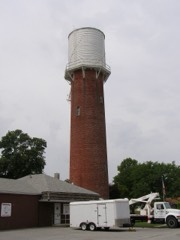 Remington Water Tower and Town Halllisted 2003
Population over time
2 figuresRemington grew from 1,185 to 1,356 between 2010 and 2020. These are the recorded population figures Wikidata holds for this place, reached through the Geographic Names Information System number this page is keyed on rather than by name, so they belong to this place and not to another of the same name. Most are census counts, but not all are: an early figure may be a founding or settlement estimate, and an estimate published within five years of a census is left out. The change column is computed, and is left blank where more than 20 years separate a figure from the one before it, because a gap that long is not a change between two counts.
| Year | People | Change |
|---|---|---|
| 2010 | 1,185 | |
| 2020 | 1,356 | +171 (+14%) |
Topographic sheets covering this place
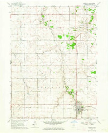
6 surveys from 9 printed sheetsMatched by testing this settlement's coordinate against the published boundary of every sheet in the United States Geological Survey's historical collection. Each opens the scanned sheet at the Survey.
- 1953 USGS Danville quadrangle1:250000, 3 printings
- 1955 USGS Danville quadrangle1:250000
- 1956 USGS Danville quadrangle1:250000
- 1963 USGS Remington quadrangle1:24000, 2 printings
- 1984 USGS Watseka quadrangle1:100000
- 1990 USGS Watseka quadrangle1:100000



Storms near this place
36 since 1996Regional context, not property-specific evidence. The National Weather Service names Remington in 36 storm reports between 1996 and 2025: 15 thunderstorm wind, 9 hail, 4 flood, 3 flash flood. No death or injury is recorded in these reports. Each account below is quoted exactly as the forecast office filed it, from the NOAA Storm Events Database, and each date opens the federal record of that event.
| When | Event | Place named | Harm | What the report says |
|---|---|---|---|---|
| February 2008 | Flood | Remington | $2,000,000 | After heavy rain and flash flooding on February 4th and 5th, flood waters slowly subsided by February 9th due to saturated and frozen ground and already high river levels. Significant flooding was reported in Rensselaer with damage to many homes. |
| February 2018 | Flood | Remington | $288,000 | Many areas of Jasper County were flooded with some roads flooded and closed. Storm total rainfall amounts included 6.50 inches two miles south southeast of Wheatfield; 6.41 inches one mile north northwest of De Motte and 4.70 inches one mile north of Rensselaer. |
| September 2008 | Flash Flood | Remington | $250,000 | Flash flooding or significant flooding was reported across parts of Jasper County, including street closures due to flooding, basement flooding and creek, stream and river flooding. Columbia Park was flooded in Rensselaer. Flood waters surrounded homes and bussinesses in DeMotte. |
| November 2013 | Tornado (EF1) | Remington | $75,000 | This is a continuation of a tornado that touched down in Newton County at 1:27 PM CST. The tornado mainly passed over open fields; however, near the end of the path an outbuilding was destroyed and small farm equipment moved, including one piece that was rolled into a grain storage bin. Debris was noted as far as a mile downstream. The highest winds were estimated to around 100 mph. |
| October 2010 | Thunderstorm Wind | Remington | $1,000 | A telephone pole was snapped. |
| March 2023 | Tornado (EF1) | Remington | - | The tornado dropped south of Goodland in rural Benton County south of E County Road 800 N east of N County Road 200 E. The storm tracked northeast and crossed into Jasper County at E County Road 900 N southwest of Remington. It lifted east of town north of W US Hwy 24 just west of N County Road 1200 W. Six semi trucks were reported flipped over on I-65 near the junction at US Hwy 24. Additionally, a trailer with a tractor in it had rolled over several times in a field off of US Hwy 24 just west of I-65. Damage otherwise mostly consisted of snapped power poles, downed trees, and damage to small farm outbuildings. |
| March 2023 | Thunderstorm Wind | Remington | - | Structural damage was reported at FBi Buildings, Inc near S County Road 380 W and W County Road 1800 S. Wind magnitude and time were estimated based on radar. |
| October 2021 | Thunderstorm Wind | Remington | - | A mesonet site east of Remington measured a wind gust to 60 mph. |
| July 2020 | Thunderstorm Wind | Remington | - | Large tree limbs were blown down in Remington. |
| June 2020 | Heavy Rain | Remington | - | Rainfall of 5.46 inches was measured in 21 hours. |
| August 2018 | Heavy Rain | Remington | - | Rainfall of 2.57 inches was measured in two hours. |
| March 2017 | Thunderstorm Wind | Remington | - | A semi was blown over near mile marker 200 on I-65. |
| August 2017 | Thunderstorm Wind | Remington | - | One large tree was blown down. |
| June 2015 | Thunderstorm Wind | Remington | - | Tree branches were blown down. |
| April 2011 | Thunderstorm Wind | Remington | - | Estimated winds of 60 mph were reported in Remington toppling a large tree across a vehicle. Another three large trees fell across roadways. Many in town were without power. |
| March 2009 | Flash Flood | Remington | - | A trailer park south of Remington had to be evacuated due to rising flood waters. Rainfall of 1.45 inches was measured in 3.5 hours in Remington. |
| September 2008 | Flood | Remington | - | Widespread flooding across parts of Jasper County slowly receded through September 16th. |
| March 2007 | Heavy Rain | Remington | - | Carpenters Creek overflowing it's banks and flooding streets. |
| March 2007 | Flood | Remington | - | Standing water was reported in fields and ditches with 2.79 inches of rainfall. |
| May 2004 | Flash Flood | Remington | - | Two to 5 inches of rain fell over the area. Street flooding was reported. |
| May 2004 | Thunderstorm Wind | Remington | - | Trees and power lines were blown down. A truck was overturned on Interstate 65. |
| May 2004 | Thunderstorm Wind | Remington | - | Six fully loaded semi tractor-trailer trucks were blown over at a truck stop at I-65 and U.S. 24. |
| March 2025 | Thunderstorm Wind | Remington | - | no account filed |
| April 2023 | Thunderstorm Wind | Remington | - | no account filed |
| December 2021 | Thunderstorm Wind | Remington | - | no account filed |
| August 2015 | Hail | Remington | - | no account filed |
| August 2012 | Hail | Remington | - | no account filed |
| August 2012 | Thunderstorm Wind | Remington | - | no account filed |
| June 2008 | Hail | Remington | - | no account filed |
| April 2006 | Hail | Remington | - | no account filed |
| April 2006 | Hail | Remington | - | no account filed |
| April 2006 | Hail | Remington | - | no account filed |
| May 2004 | Hail | Remington | - | no account filed |
| July 2004 | Hail | Remington | - | no account filed |
| July 2003 | Hail | Remington | - | no account filed |
| January 1996 | Thunderstorm Wind | Remington | - | no account filed |
Nearest settlements
The eight closest, with where each one stands in the county. Distances are straight-line, computed from the Geographic Names Information System coordinates.
| Map | Place | Distance | Sheets |
|---|---|---|---|
| Fountain Park | 1.4 miles | 9 | |
| Egypt | 7.3 miles | 9 | |
| Collegeville | 10.4 miles | 10 | |
| South Marion | 10.5 miles | 10 | |
| Rensselaer | 12.1 miles | 10 | |
| McCoysburg | 12.6 miles | 8 | |
| Pleasant Ridge | 12.6 miles | 8 | |
| North Marion | 14.5 miles | 10 |
Elsewhere
Matched on this settlement's Geographic Names Information System number rather than its name, so it cannot be a different place of the same name in another state.
| Wikipedia article on Remington | An encyclopaedic summary. Its text is share-alike, so it is linked here rather than copied. |
| Wikidata item Q2654506 | The structured record the population and elevation above come from. Public domain (CC0). |
Provenance
This settlement is recorded in the Geographic Names Information System as feature 441891. The sheet list is computed by point-in-boundary test against the United States Geological Survey's historical topographic inventory. Both are works of the United States government and carry no copyright under 17 U.S.C. 105.
Storms. NOAA National Centers for Environmental Information, Storm Events Database https://www.ncei.noaa.gov/stormevents/ A work of the United States government, no copyright under 17 U.S.C. 105. Narratives are quoted verbatim from the National Weather Service report and are not edited or summarised.