
BlockBefore
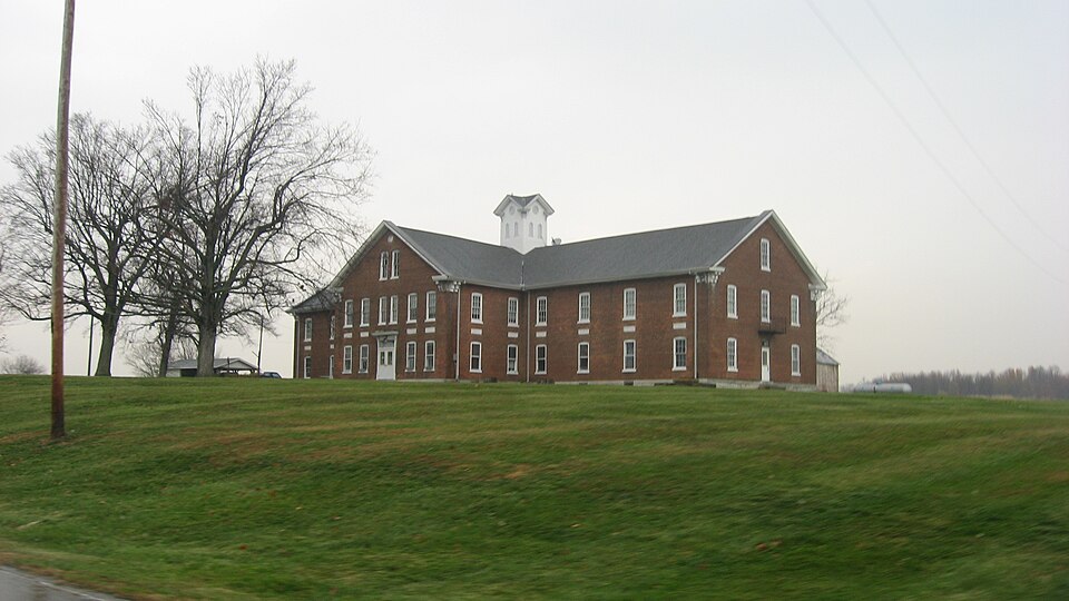
Photograph of Dearborn County Asylum for the Poor
Photograph by Nyttend, Public domain. Via Wikimedia Commons.

Dearborn County Asylum for the Poor

Listed on the National Register of Historic Places in 2000.

From the record

“Dearborn County Asylum for the Poor, also known as the Dearborn County Home, is a historic poor house located in Manchester Township, Dearborn County, Indiana. It was built in 1882, and is a cruciform plan, Late Victorian style brick building.”

Wikipedia article Dearborn County Asylum for the Poor, CC BY-SA 4.0.

One of 26 National Register listings published here for Dearborn County · listed in 2000 · category: Building.

Sources: the Wikipedia article · the case file at the National Archives · the National Register database, National Park Service
The listing

  • What is counted as historic. The nomination lists 2 buildingss as contributing to the listing.
  • Address. 11636 County Farm Rd., Aurora, 47001
  • When was it listed? September 2000
  • Category. building
  • Township. Manchester township
  • National Register reference number. 00001143 - the number the National Park Service assigned this property when it was listed, and the key its nomination file is catalogued under at the National Archives.

The ground it stands on

3,544 words

The chapter on Manchester Township in History of Dearborn County Indiana, published 1915 names Aurora. This is what it says, exactly as the scans read.

During the year 1815 David, George and Joseph Johnston, from Fred¬ erick county, Virginia, located on north Hogan, in the township. They had left Virginia in 1810, settling first in Butler county, Ohio, and in 1812 re¬ moving to Vincennes, then they came to Louisville, Kentucky, and in 1814 to where Aurora was later built, and a year later to Manchester township.

Passage source: History of Dearborn County Indiana, published 1915.

In 1876 George W. Lane nad an article in the Aurora Independent which spoke of the township of Manchester as follows : "Soon after the War of 1812 one of the most important settlements for numbers and character was made in Manchester township. They suffered many hardships and, indeed, many privations, but they stood their ground like Christian martyrs and many lived to see tall oaks utilized for other purposes and removed to make room for houses, barns and meadows, and in less than a decade the ridge was under a high state of cultivation for miles, and in the fall rows of teams would be seen on the road hauling off the surplus of their farms and cooper shops. The latter work was carried on for a number of years, as Manchester was studded over with heavy timber, the tallest and largest trees this side of California, and to work up these great oaks into pork barrels required the labor of Mr. Jaquith and all of his boys, and these boys were as good, jovial fellows as were ever turned loose in any big woods.

Passage source: History of Dearborn County Indiana, published 1915.

Machine-read from a century-old scan, so expect the errors a machine makes: misspelled names, dropped words, stray characters.

Read the whole chapter on Manchester Township - 3,544 words on its settlement, mills, schools and churches.

Storms near this property

32 since 1996

Regional context, not property-specific evidence. The National Weather Service names Aurora, the town this property stands in, in 32 storm reports between 1996 and 2022: 12 thunderstorm wind, 9 flash flood, 6 flood, 4 hail. No death or injury is recorded in these reports. Each account below is quoted exactly as the forecast office filed it, from the NOAA Storm Events Database, and each date opens the federal record of that event.

WhenEvent Place namedHarm What the report says
April 1999Tornado (F0)Aurora$250,000A small barn was totally destroyed, a 40 foot silo was damaged and several trees were downed. Four homes were heavily damaged in rural Dillsboro.
June 2021Flash FloodAurora$100,000Numerous reports of high water and flash flooding were received from the Aurora and Guilford areas. Several people and pets were stranded in Guilford due to rising water. Two vehicles were also swept away in the Guilford area after their occupants escaped.
March 1997Thunderstorm WindAurora$30,000no account filed
June 2008Thunderstorm WindAurora$20,000A neighborhood near Aurora sustained structural damage to some homes and automobiles, as well as numerous trees being blown down, uprooted, or split. All of the damage was caused by straight-line winds estimated near 80 mph.
June 2017Flash FloodAurora$15,000A portion of Market Street in Aurora was ripped up due to flood waters.
March 2008FloodAurora$5,000Numerous roads were flooded across the county.
March 2008FloodAurora$5,000Numerous roads were flooded and closed.
June 2022Thunderstorm WindAurora$4,000Several trees were downed.
July 2022Thunderstorm WindAurora$3,000A few trees were downed.
May 2018Thunderstorm WindAurora$3,000A few trees were downed onto State Route 148.
April 2011Thunderstorm WindAurora$2,000Trees were reported down due to damaging thunderstorm winds.
February 2006Thunderstorm WindAurora$2,000Two trees were knocked down.
April 2006Thunderstorm WindAurora$2,000Power lines were downed.
July 2014Thunderstorm WindAurora$1,000A tree was downed due to thunderstorm winds.
June 2013Flash FloodAurora$1,000Multiple roads were closed due to high water caused by heavy rainfall.
April 2011Thunderstorm WindAurora$1,000Large branches were broken due to damaging thunderstorm winds.
July 2019Thunderstorm WindAurora$250A few small trees were downed on Wilson Creek Road.
May 2022FloodAurora-High water was reported on the roadway near the intersection of State Route 148 and U.S. 50.
February 2019FloodAurora-U.S. 50 westbound in Aurora was blocked due to high water.
February 2019FloodAurora-One road was closed near the Ohio County line due to flooding.
June 2019FloodAurora-High water was reported over 1 1/2 lanes of Wilson Creek Road.
February 2018Flash FloodAurora-Multiple roads were closed throughout the county due to high water.
March 2006Flash FloodAurora-High water caused several road closures.
May 2002Flash FloodAurora-An automobile was trapped when high water surged over a bridge.
May 2002Flash FloodAurora-Laughery Creek Road was closed by high water.
August 2001Flash FloodAurora-Heavy rainfall caused roads to be closed across the southern part of the county.
May 2022HailAurora-no account filed
April 2017Flash FloodAurora-no account filed
July 2014Thunderstorm WindAurora-no account filed
May 2011HailAurora-no account filed
June 1998HailAurora-no account filed
August 1996HailAurora-no account filed

Every storm recorded in Dearborn County

Map coverage status

No historic map-sheet match is published for this property yet. That does not mean no map exists. This record needs a coordinate-quality review before it can be joined to a sheet boundary. Browse the county's mapped places while that work is pending.

Listed places nearby

2 within 8 miles

Other National Register properties close enough to walk or drive between, ordered by distance from this one. Both positions come from the same geocoding pass that matched these properties to their map sheets.

Photograph PropertyDistance Listed
Moore's Hill United Methodist Church3.9 miles1997
Carnegie Hall of Moores Hill College4.1 miles1994

Sources for this property

National Archives recordThe nomination case file for reference 00001143 in Record Group 79.
Wikipedia articleCommunity-written account of this property, licensed CC BY-SA.
Dearborn CountyAll 26 listed properties in this county.

Provenance

  • Listing record. National Park Service National Register of Historic Places, listed-properties dataset, current to 2026-05-22.
  • Map join. Address geocoded through the United States Census geocoder, then tested against the published boundary of every sheet in the USGS Historical Topographic Map Collection.
  • How this page is made. Listing fields come from federal records; map-sheet coverage is a labelled coordinate-to-boundary calculation, not a source-field claim.
  • Storms. NOAA National Centers for Environmental Information, Storm Events Database https://www.ncei.noaa.gov/stormevents/ A work of the United States government, no copyright under 17 U.S.C. 105. Narratives are quoted verbatim from the National Weather Service report and are not edited or summarised.