
BlockBefore
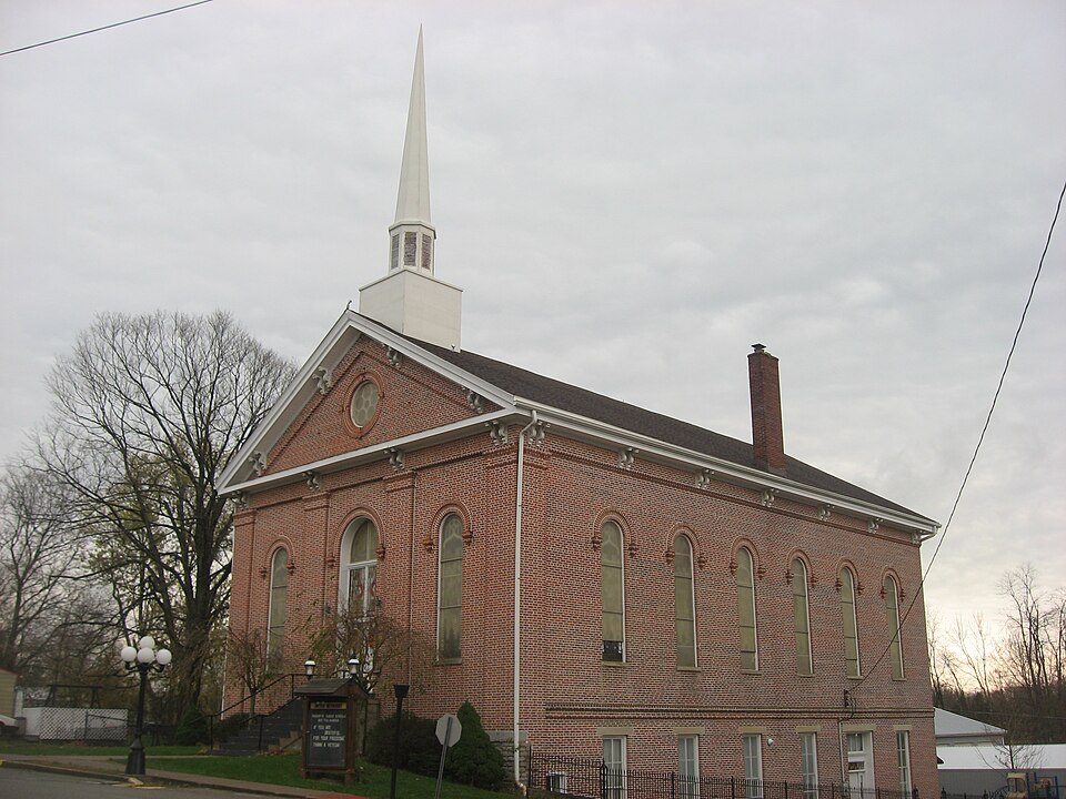
Photograph of Moores Hill United Methodist Church
Photograph by Nyttend, Public domain. Via Wikimedia Commons.

Moore's Hill United Methodist Church

Listed on the National Register of Historic Places in 1997.

From the record

“Moore's Hill United Methodist Church, also known as Methodist Episcopal Church, is a historic Methodist church located at 13476 Main Street in Moores Hill, Indiana. Although it was built in 1871, the congregation was founded in 1818.”

Wikipedia article Moores Hill United Methodist Church, CC BY-SA 4.0.

One of 26 National Register listings published here for Dearborn County · listed in 1997 · category: Building.

Sources: the Wikipedia article · the case file at the National Archives · the National Register database, National Park Service

The listing

  • What is counted as historic. The nomination lists 1 building as contributing to the listing.
  • Address. 13476 Main St., Moores Hill, 47032
  • When was it listed? December 1997
  • Category. building
  • Township. Sparta township
  • Architectural style. Renaissance Revival architecture
  • National Register reference number. 97001537 - the number the National Park Service assigned this property when it was listed, and the key its nomination file is catalogued under at the National Archives.

The ground it stands on

2,127 words

The chapter on Sparta Township in History of Dearborn County Indiana, published 1915 names Moores Hill. This is what it says, exactly as the scans read.

Samuel B. and Winslow Wood emigrated from New York state in 1817. Jonathan Vail emigrated from New York state in 1817, and died in 1847. Stephen Inman came from the state of Maine in 1817. Nathaniel Richman came from the state of New York in 1818, and died in 1859. Gilbert Givan came from Maryland in 1818, and died in 1868. Adam Moore and family came from Maryland in 1818, and settled on the site of the town of Moores Hill. John C. Moore, his son, who was bom in Maryland in 1810, died in 1871. Samuel Marshall was bom in London, England, and was married in New York City and in 1818 settled in Sparta township.

Passage source: History of Dearborn County Indiana, published 1915.

In the fall of 1818 a wagon road was cut through the woods from what is now Aurora to Moores Hill and to the Ripley county line. The first natural death is thought to have occurred in the township was that of Riley Truitt, which occurred in the year 1818. Adam Moore erected a grist-mill soon after he settled. It was a tread-wheel worked by animal power. A saw-mill was erected on North Hogan in 1830, by Lyman Smith., In 1828 James Hayes erected a grist-mill on South Hogan, in the wester part of the township, which he operated for about fifteen years, when in an attempt to cut the ice from the water wheel he fell and was crushed to death. The mill was after¬ wards operated by Joseph Bossong and Jacob Zapp. One of the first steam mills in the county was erected by Phineas King in the year 1839, and was run together with a woolen factory, which had previously been run by a tread wheel. It was situated on King's ridge near Chesterville, After King's death the machinery was removed to Milan. William Bt Miller, in the year 1839, erected the mills known as "Miller's Mills," in the southern part of the township on South Hogan. The first tan yard was started in 1817 by Samuel and Winslow Wood.

Passage source: History of Dearborn County Indiana, published 1915.

Machine-read from a century-old scan, so expect the errors a machine makes: misspelled names, dropped words, stray characters.

Read the whole chapter on Sparta Township - 2,127 words on its settlement, mills, schools and churches.

Storms near this property

9 since 1993

Regional context, not property-specific evidence. The National Weather Service names Moores Hill, the town this property stands in, in 9 storm reports between 1993 and 2011: 7 thunderstorm wind, 2 hail. No death or injury is recorded in these reports. Each account below is quoted exactly as the forecast office filed it, from the NOAA Storm Events Database, and each date opens the federal record of that event.

WhenEvent Place namedHarm What the report says
August 1993HailMoores Hill$500,000no account filed
December 2006Thunderstorm WindMoores Hill$10,000Trees were knocked down across the county.
May 2011Thunderstorm WindMoores Hill$3,000Trees and large tree limbs were reported down due to damaging thunderstorm winds.
June 2008Thunderstorm WindMoores Hill$3,000Trees were downed.
June 2010Thunderstorm WindMoores Hill$1,000Trees were reported down due to damaging thunderstorm winds.
April 1996Thunderstorm WindMoores Hill$1,000no account filed
May 2002HailMoores Hill-no account filed
March 1996Thunderstorm WindMoores Hill-no account filed

Every storm recorded in Dearborn County

Map coverage status

No historic map-sheet match is published for this property yet. That does not mean no map exists. This record needs a coordinate-quality review before it can be joined to a sheet boundary. Browse the county's mapped places while that work is pending.

Listed places nearby

3 within 8 miles

Other National Register properties close enough to walk or drive between, ordered by distance from this one. Both positions come from the same geocoding pass that matched these properties to their map sheets.

Photograph PropertyDistance Listed
Carnegie Hall of Moores Hill College0.3 miles1994
Dearborn County Asylum for the Poor3.9 miles2000
Walker Hill Farm7.4 miles2025

Sources for this property

National Archives recordThe nomination case file for reference 97001537 in Record Group 79.
Wikipedia articleCommunity-written account of this property, licensed CC BY-SA.
Dearborn CountyAll 26 listed properties in this county.

Provenance

  • Listing record. National Park Service National Register of Historic Places, listed-properties dataset, current to 2026-05-22.
  • Map join. Address geocoded through the United States Census geocoder, then tested against the published boundary of every sheet in the USGS Historical Topographic Map Collection.
  • How this page is made. Listing fields come from federal records; map-sheet coverage is a labelled coordinate-to-boundary calculation, not a source-field claim.
  • Storms. NOAA National Centers for Environmental Information, Storm Events Database https://www.ncei.noaa.gov/stormevents/ A work of the United States government, no copyright under 17 U.S.C. 105. Narratives are quoted verbatim from the National Weather Service report and are not edited or summarised.