
BlockBefore
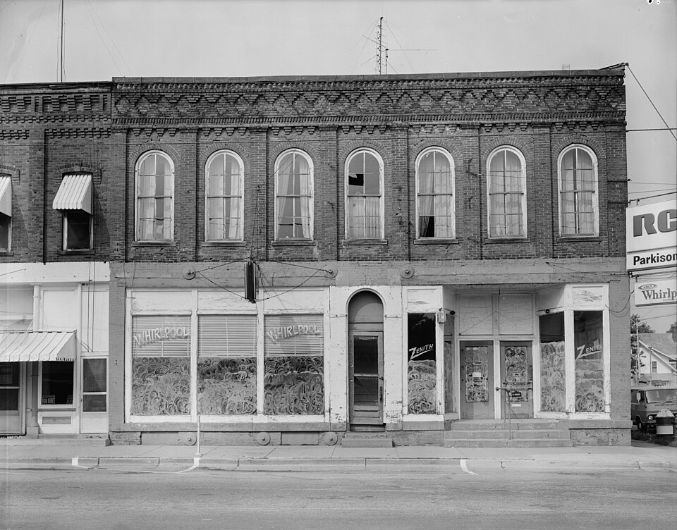
Photograph of Downtown Butler Historic District
Photograph by Unknown, Public domain. Via Wikimedia Commons.

Downtown Butler Historic District

Listed on the National Register of Historic Places in 2001.

From the record

“Downtown Butler Historic District is a national historic district located at Butler, Indiana. The district encompasses 30 contributing buildings in the central business district of Butler.”

Wikipedia article Downtown Butler Historic District, CC BY-SA 4.0.

One of 29 National Register listings published here for DeKalb County · listed in 2001 · category: District.

Sources: the Wikipedia article · the case file at the National Archives · the National Register database, National Park Service
The listing

  • Address. Roughly 100 & 200 Blks of South Broadway, Butler, 46721
  • When was it listed? December 2001
  • Category. district
  • Township. Wilmington township
  • National Register reference number. 01001347 - the number the National Park Service assigned this property when it was listed, and the key its nomination file is catalogued under at the National Archives.

The ground it stands on

2,634 words

The chapter on Wilmington Township in History of Dekalb County, Indiana, with Biographical Sketches of Representative Citizens and Genealogical Records of Old Families, published 1914 names Butler. This is what it says, exactly as the scans read.

The township of Wilmington lies in the east central portion of the county, and is bounded as follows : On the north by Franklin township, on the east by Stafford, on the south by Concord, and on the west by Grant and Union. S. B. Ward, a pioneer minister, thus described the township: "It is a second rate township in quality of soil, taking it together, yet it has some first rate land in it, especially along 'Big Run,' a considerable stream running across the north side of the township. For fine oak timber, there is no township in the county that surpasses it." The timber, except the second growth, is largely cleared away now, and the land has developed into very fair agricultural ground. The Lake Shore & Michigan Southern, the Vandalia of the Pennsylvania system, and the Wabash railroads all cross the township, meeting at Butler, in the northeast corner.

Passage source: History of Dekalb County, Indiana, with Biographical Sketches of Representative Citizens and Genealogical Records of Old Families, published 1914.

In 1856 the township was "boomed" considerably by the construction of the air line of the Michigan Southern railroad, and the consequent growth of Butler, at first called Norristown. A market was opened for surplus agricultural products, prices went up, and there was a consequent improvement of the lands and equipment of the farmers. The construction of the second railroad in 1872, and the Wabash in 1892, gave a clinch to the prosperity, and this progressive township has continued to grow ever since.

Passage source: History of Dekalb County, Indiana, with Biographical Sketches of Representative Citizens and Genealogical Records of Old Families, published 1914.

Machine-read from a century-old scan, so expect the errors a machine makes: misspelled names, dropped words, stray characters.

Read the whole chapter on Wilmington Township - 2,634 words on its settlement, mills, schools and churches.

Storms near this property

14 since 2000

Regional context, not property-specific evidence. The National Weather Service names Butler, the town this property stands in, in 14 storm reports between 2000 and 2019: 7 hail, 7 thunderstorm wind. No death or injury is recorded in these reports. Each account below is quoted exactly as the forecast office filed it, from the NOAA Storm Events Database, and each date opens the federal record of that event.

WhenEvent Place namedHarm What the report says
June 2001Thunderstorm WindButler$750Roof blown off porch of house.
June 2014Thunderstorm WindButler-Emergency management officials reported a tree was blown down onto a residence.
June 2014Thunderstorm WindButler-Emergency management officials reported trees and utility line down from Corunna to Butler.
June 2010Thunderstorm WindButler-Law enforcement officials reported multiple trees and tree limbs down, with some blocking roadways.
June 2006Thunderstorm WindButler-Trees reported down on State Route 1
May 2004Thunderstorm WindButler-Law enforcement reported several trees down in Butler.
June 2000Thunderstorm WindButler-Several trees and power lines down.
June 2019HailButler-no account filed
May 2014HailButler-no account filed
March 2003HailButler-no account filed
July 2003HailButler-no account filed
June 2001HailButler-no account filed
June 2000HailButler-no account filed

Every storm recorded in DeKalb County

Map coverage status

No historic map-sheet match is published for this property yet. That does not mean no map exists. This record needs a coordinate-quality review before it can be joined to a sheet boundary. Browse the county's mapped places while that work is pending.

Listed places nearby

2 within 8 miles

Other National Register properties close enough to walk or drive between, ordered by distance from this one. Both positions come from the same geocoding pass that matched these properties to their map sheets.

Photograph PropertyDistance Listed
Butler Community Mausoleum1.5 miles2014
Waterloo Community Mausoleum7.7 miles2014

Sources for this property

National Archives recordThe nomination case file for reference 01001347 in Record Group 79.
Wikipedia articleCommunity-written account of this property, licensed CC BY-SA.
DeKalb CountyAll 29 listed properties in this county.

Provenance

  • Listing record. National Park Service National Register of Historic Places, listed-properties dataset, current to 2026-05-22.
  • Map join. Address geocoded through the United States Census geocoder, then tested against the published boundary of every sheet in the USGS Historical Topographic Map Collection.
  • How this page is made. Listing fields come from federal records; map-sheet coverage is a labelled coordinate-to-boundary calculation, not a source-field claim.
  • Storms. NOAA National Centers for Environmental Information, Storm Events Database https://www.ncei.noaa.gov/stormevents/ A work of the United States government, no copyright under 17 U.S.C. 105. Narratives are quoted verbatim from the National Weather Service report and are not edited or summarised.