BlockBefore
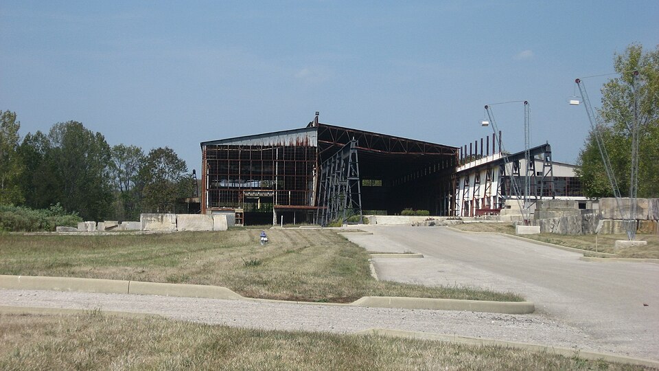
Photograph of Woolery Stone Company
Photograph by Nyttend, Public domain. Via Wikimedia Commons.

Woolery Stone Company

Listed on the National Register of Historic Places in 2002.

From the record

“Woolery Stone Company is a historic limestone quarry and manufacturing complex located at Bloomington, Indiana. The property includes a variety of buildings, structures, and objects associated with the production of dimensional limestone.”

Wikipedia article Woolery Stone Company, CC BY-SA 4.0.

One of 48 National Register listings published here for Monroe County · listed in 2002 · category: Site.

Sources: the Wikipedia article · the case file at the National Archives · the National Register database, National Park Service

The listing

  • Address. 2295 W. Tapp Rd., Bloomington, 47403
  • When was it listed? December 2002
  • Category. site
  • Township. Perry township
  • National Register reference number. 02001563 - the number the National Park Service assigned this property when it was listed, and the key its nomination file is catalogued under at the National Archives.

The ground it stands on

8,019 words

The chapter on Perry Township in 1884 History of Monroe County Indiana, published 1884 names Bloomington. This is what it says, exactly as the scans read.

Township 8 north, Range 1 west, was one of two in the State of Indiana, devoted by Legislative enactment to special school purposes. The Indiana State University was then unknown, and its future place in the social system of humanity was unthought of. In the year 1820, the General Assembly of Indiana, in pursuance of an act of Congress, selected two full Congressional townships - one in Gibson County, and the other in Monroe County - to be used in founding and maintaining two State Seminaries. The selection was made through the medium of commissions appointed by the State Legislature, such officers being required to locate the townships, and carry into effect other provisions specified. This was done, Perry Township, or as it was only known then, Township 8 north, Range 1 west, being the one selected in Monroe County. 'Trustees were appointed to superintend the erection of the necessary seminary buildings - two, one for the school, and the other for the Principal to occupy. This work was done in 1822, four sections of land on the north side of the township being reserved for the grounds, etc., of the seminary. The sections thus reserved were all of No. 4, No. 5, the west half of No. 3, the east half of No. 6, the west half of No. 9, and the east half of No. 8, making in all four full sections. These sections were reserved from sale, and squatters were not permitted to make improvements, such as clearing the land, erecting buildings, planting crops, etc. It was different, however, on the remainder of the township. The citizens were, of course, aware that at some future day the lands of the townsbip, except perhaps the reserved sections, would be thrown into market and sold in parcels to suit purchasers for the highest price that could be obtained. None of the land was remote from the county seat, and much of it was near, and, in addition, the rapid growth of Bloomington, the location of a State Seminary there and the appearance of educators and citizens of unusual culture, caused the soil of Perry Township to be greatly coveted, and early in the twenties its bounds were invaded by an army of eager squatters, who, regardless of the fact that they had no right there, went to work erecting buildings in which to live, cutting down the forests to get fields for agriculture, constructing mills, etc., etc., as if the land were already their legal property. The years passed, but still the lands remained unsold, though quite numerously occupied. The squatters continuously clamored for the sale to be made, and at last, in 1827, the Legislature provided for the appraisement of the land and for its appearance in market. This caused the squatters to become anxious. Several of them had made quite extensive improvements in clearing and building, and the sale meant that their claims should be subjected to the competitive bids of speculators, prospective residents and themselves. The speculators, for instance, could bid on a squatter's claim, and, if willing to buy the improvements which the law of pre-emption required of him, could run the farm above the price which the squatter himself was willing or able to give, and could secure the home of the settler in spite of all that he could do. Nothing serious, however, was done, though there was some sharp competition for tracts of land of superior quality, or of favor-

Passage source: 1884 History of Monroe County Indiana, published 1884.

The poorest land, class 3, could not be sold for less than the Government price of $1.25 per acre, and might be sold for any amount above that figure. A minimum price was also fixed for the first and second classes. The sale began in October (the sections and parts of sections marked reserved in the plat not being subject to sale), and during the remainder of that year (1827) the following men became purchasers : Alexander Kelley, Joseph Piercy, John Armstrong, and John Griffith on Section 1; James G. Fleener, Granville Ward, Milton McPhetridge, Isaac Rogers, Aquilla Rogers and Samuel Dunn on Section 2; Thomas Smith on Section 3; George Henry, James Borland, Ellis Stone and Hiram Paugh on Section 6; Emsley Wilson, Andrew Dodds, Abraham Pauley, Richard Hunter and Alexander Murphy on Section 7; Samuel Dodds, Richard Shipp and John Hight on Section 8; William Bilbo on Section 9; Benjamin Rogers, David Batterton and Zachariah Williams on Section 10; Jobn Griffith and Jacob Isominger on Section 11; Garrett Moore, John A. Wilson and Moses Williams on Section 12; Benjamin Rogers on Section 14; Josiah Baker and Abed Nego Walden on Section 15; William Dunning, Levi Thatcher and Williams Knatts on Section 16; Isaac Pauley, Daniel Davis, Thomas Carter and Absalom Kennedy on Section 17; Isaac Pauley, Edward Borland and Samuel Moore on Section 18; Simon Adamson on Section 19; Jacob Depue, Evan Dallarhide, David Sears and John Mathers on Section 20; Robert D. Alexander, William Davis, John W. Nicholson, William Taylor, Michael Keith and David Findley on Section 21; John Boltinghouse, William Patrick and William Taylor on Section 22; Solomon Butcher, Banner Brummet and James Berryman on Section 27; William 'Taylor, James Alexander, William Alverson, John Musser, Robert Sanderson, James Brummet and Thomas Abbott on Section 28; William Alverson, Carey James, David Sears, William Henry, James Parsons and Charles Brookshire on Section 29; Samuel Rhorer, Solomon Green, John Smith and Absalom Cooper on Section 30; John Smith on Section 31; William Ross and Alexander Miller on Section 32; George Short and Moses Grantham on Section 33; William Chandler on Section 34. These were the only purchasers in 1827, and, of course. include all the squatters who were very anxious to get a title to the land upon which they had been living and had been for years saving money for that purpose. Several residents of Bloomington and other portions of the county were among the buyers. During the following year, 1828, the entries, though quite numerous, were not half so many as in 1827. After the first rush, the sale languished and fell back to its place with the remainder of the county. The land was not subject to entry in the usual way at the land offices. It was under the control of a special Commissioner who was em-

Passage source: 1884 History of Monroe County Indiana, published 1884.

Machine-read from a century-old scan, so expect the errors a machine makes: misspelled names, dropped words, stray characters.

Read the whole chapter on Perry Township - 8,019 words on its settlement, mills, schools and churches.

Fires near this property

88 since 2003

Regional context, not property-specific evidence. The federal wildfire occurrence database lists 88 fires within 5 miles of Woolery Stone Company between 2003 and 2008, burning about 43 acres in total. 1 started naturally. 10 were recorded as arson. Distance is straight-line from the map coordinates, so a fire counted here may appear on a neighbouring settlement's page as well.

Reported cause Fires
Recreation and ceremony28
Debris and open burning27
Missing data/not specified/undetermined16
Arson/incendiarism10
Smoking4
Other causes1
Natural1
Equipment and vehicle use1

The most recent of them, most recent first, with the day each was reported and the service that recorded it.

DateCause SizeReported by Name on the report
9 September 2005Debris and open burningunder an acreIndiana State Fire Marshal's Officenot named
7 September 2007Missing data/not specified/undeterminedunder an acreIndiana State Fire Marshal's Officenot named
3 September 2007Arson/incendiarismunder an acreIndiana State Fire Marshal's Officenot named
3 September 2007Recreation and ceremony1.0 acresIndiana State Fire Marshal's Officenot named
20 September 2007Debris and open burning1.0 acresIndiana State Fire Marshal's Officenot named
18 September 2006Missing data/not specified/undeterminedunder an acreIndiana State Fire Marshal's Officenot named
15 September 2006Recreation and ceremonyunder an acreIndiana State Fire Marshal's Officenot named
1 September 2005Arson/incendiarismunder an acreIndiana State Fire Marshal's Officenot named

Every fire recorded in Monroe County

Mines and quarries near this property

10 of 24 shown

Regional context, not property-specific evidence. The federal mineral resources record lists 24 workings within 5 miles of Woolery Stone Company: 17 past producers, 7 producers. 7 still produce. What was taken out: Limestone, Dimension, Flagstone, Stone, Crushed/Broken, Stone. Distance is straight-line from the map coordinates, so a quarry counted here may appear on a neighbouring settlement's page as well.

Where SiteCommodity StatusRecorded
Bloomington LimestoneStoneProducer
Bloomington QuarryStone, Crushed/BrokenProducer
Hinkle Sandstone QuarryFlagstonePast Producer
4-R QuarryLimestone, DimensionPast Producer
Acme QuarryLimestone, DimensionPast Producer
Adams QuarryLimestone, DimensionPast Producer
Arlington Hills QuarryLimestone, DimensionProducer
Arlington MillLimestone, DimensionPast Producer
Arlington QuarryLimestone, DimensionPast Producer
Ashtone MillLimestone, DimensionPast Producer

Every working recorded in Monroe County

Storms near this property

60 of 109 shown

Regional context, not property-specific evidence. The National Weather Service names Bloomington, the town this property stands in, in 109 storm reports between 1994 and 2026: 52 thunderstorm wind, 44 hail, 5 flash flood, 4 flood. The reports record 1 death and 3 injuries. Each account below is quoted exactly as the forecast office filed it, from the NOAA Storm Events Database, and each date opens the federal record of that event.

WhenEvent Place namedHarm What the report says
October 2000Flash FloodBloomington1 killedno account filed
June 2008LightningBloomington3 hurtTwo individuals had lightning strike near them and were taken to the hospital for lighting related injuries. The cell phone of another individual was stuck while the person was talking on the phone. This individual was also taken to the hospital for treatment.
June 2024Thunderstorm WindBloomington$5,000,000Widespread significant tree damage across the city of Bloomington with numerous reports of property damage due to fallen trees and tree limbs.
April 2000Thunderstorm WindBloomington$200,000no account filed
May 2004Tornado (F0)Bloomington$150,000An F0 tornado moved across Lake Monroe southeast of Bloomington sinking several sailboats.
June 1998Thunderstorm WindBloomington$60,000Thunderstorm winds to 70 mph blew down dozens of trees and power lines. Up to four homes and several vehicles were damaged by fallen trees.
August 2004Thunderstorm WindBloomington$30,000Trees were downed in several locations across Bloomington, including one that crushed a car and another that fell on a barn. Damage amounts were estimated.
April 2006Thunderstorm WindBloomington$20,000Trees fell on a house.
May 2011Thunderstorm WindBloomington$15,000Several large trees were reported down due to damaging thunderstorm wind gusts.
May 2011Thunderstorm WindBloomington$15,000Multiple trees were reported down across Bloomington due to damaging thunderstorm wind gusts.
May 2011Thunderstorm WindBloomington$12,000Many trees and limbs were reported down due to damaging thunderstorm wind gusts.
September 2014Thunderstorm WindBloomington$10,000Trees were downed and a few homes sustained minor damage in an eastside Bloomington neighborhood.
January 2012Thunderstorm WindBloomington$9,000Three trees were blown down along State Route 45 due to damaging thunderstorm wind gusts. Two of the downed trees were at the intersection of State Route 45 and Russell Road. The other downed tree was just southwest of town. Two of the three trees looked healthy. Both instances of trees down at State Route 45 and Russell Road hit homes and caused minor roof damage.
August 2023Thunderstorm WindBloomington$5,000Thunderstorm winds caused tree damaged in Bloomington.
June 2010Thunderstorm WindBloomington$5,000Trees, up to 10 inches in diameter, were reported down due to damaging thunderstorm wind gusts on Moores Pike.
June 2010Thunderstorm WindBloomington$5,000Trees, up to 10 to 14 inches in diameter, were reported down due to damaging thunderstorm wind gusts in this location.
June 2008Flash FloodBloomington$5,000Roadways were covered and previous flooding conditions were exacerbated due to heavy rainfall that caused renewed flash flooding.
April 1994Thunderstorm WindBloomington$5,000An automobile was totaled after a large tree fell on top of it.
April 2011Flash FloodBloomington$2,000Multiple intersections were reported to be flooded with water up to about a foot deep.
June 1995Thunderstorm WindBloomington$2,000Trees and power lines were downed on the east side of Bloomington.
June 1995Thunderstorm WindBloomington$2,000Trees and power lines were downed in Bloomington.
February 2014FloodBloomington$1,000Streets were reported to be flooded due to heavy thunderstorm rainfall. The campus bus routes were suspended.
June 2009Flash FloodBloomington$1,000Streets were reported to be flooded in Bloomington due to thunderstorm heavy rainfall.
June 2009Flash FloodBloomington$1,000Flash flooding of some county roads were reported throughout Monroe County due to thunderstorm heavy rainfall. A few intersections in Bloomington were flooded as well. The location of this event is estimated.
May 2002Thunderstorm WindBloomington$1,000Trees down
May 1996Thunderstorm WindBloomington$1,000no account filed
March 1996Thunderstorm WindBloomington$1,000no account filed
July 2008Thunderstorm WindBloomington$800Thunderstorm winds blew a tree down.
June 2015FloodBloomington$500Some minor street flooding was reported in this location due to heavy rainfall.
July 2013Thunderstorm WindBloomington$500A trained spotter reported several tree branches down due to an estimated 60 mph thunderstorm wind gust.
January 2012FloodBloomington$500Heavy thunderstorm rainfall caused 3.5 inches of standing water at the intersection of 3rd and Jordan Streets.
August 2004Tornado (F0)Bloomington$500A very small and brief tornado touched down from a thunderstorm near Bloomington, causing damage to several trees in the backyard of a residence. No one was injured, and no other significant damage was reported.
May 2011Thunderstorm WindBloomington$200A four inch diameter tree branch was reported down at 10th and Walnut Streets.
June 2025Thunderstorm WindBloomington-Trained spotter estimated thunderstorm wind gusts up to 70 mph.
June 2024Thunderstorm WindBloomington-A 60 mph thunderstorm wind gust was measured at this location.
April 2024HailBloomington-Mainly 0.88 inch or smaller hail across Monroe County, included one golf ball sized hailstone, which was likely advected from the cluster's main updraft crossing southeastern portions of Monroe County. One-inch hail was also reported near and southeast of Bloomington.
June 2023HailBloomington-Thunderstorm hail continued, as large as quarters in Bloomington.
July 2023HailBloomington-Nickel sized hail on north side of Bloomington. Numerous reports of 0.50-0.75 inch hail from south of Ellettsville, through Bloomington, to near/southwest of Woodville Hills.
May 2017HailBloomington-This report was received via Facebook.
March 2012HailBloomington-The hail lasted for 10 minutes.
April 2011Thunderstorm WindBloomington-A thunderstorm wind gust, estimated at 60 mph, was reported in Bloomington.
May 2011Thunderstorm WindBloomington-A 70 to 80 mph thunderstorm wind gust was reported in this location, with much debris.
August 2011Thunderstorm WindBloomington-An estimated 60 mph thunderstorm wind gust was observed in this location. Pea-sized hail was also observed.
August 2009Thunderstorm WindBloomington-A spotter estimated thunderstorm wind gusts between 60 to 70 miles per hours in Bloomington.
January 2008Thunderstorm WindBloomington-The wind gust was measured by ASOS equipment.
April 2007Thunderstorm WindBloomington-Trees were reported down in several places due to damaging thunderstorm winds.
March 2006FloodBloomington-Two roads were closed due to high water. No property damage was reported.
April 2006HailBloomington-No property damage estimates were available.
May 2005Thunderstorm WindBloomington-Several trees were blown down.
May 2005Thunderstorm WindBloomington-Trees were downed near Bloomington.
May 2005Thunderstorm WindBloomington-Power lines were blown down at the south end of Lake Monroe.
June 2005Thunderstorm WindBloomington-Trees were blown down.
July 2005Thunderstorm WindBloomington-Large tree limbs fell.
November 2005Thunderstorm WindBloomington-Trees were downed.
July 2004Thunderstorm WindBloomington-A large tree was downed.
July 2004Thunderstorm WindBloomington-Trees were downed.
July 2003Thunderstorm WindBloomington-Trees down in Harrodsburg
May 2002Thunderstorm WindBloomington-Large limbs down
April 2002HailBloomington-Hail covered the ground

Every storm recorded in Monroe County

Map coverage status

No historic map-sheet match is published for this property yet. That does not mean no map exists. This record needs a coordinate-quality review before it can be joined to a sheet boundary. Browse the county's mapped places while that work is pending.

Listed places nearby

6 within 8 miles

Other National Register properties close enough to walk or drive between, ordered by distance from this one. Both positions come from the same geocoding pass that matched these properties to their map sheets.

Photograph PropertyDistance Listed
Carter-Randall-Parker House1.6 miles2018
McDoel Historic District1.6 miles2021
Courthouse Square Historic District1.9 miles1990
Princess Theatre2.0 miles1983
Prospect Hill Historic District2.1 miles1991
Seminary Square Park2.1 miles1977

Sources for this property

National Archives recordThe nomination case file for reference 02001563 in Record Group 79.
Wikipedia articleCommunity-written account of this property, licensed CC BY-SA.
Monroe CountyAll 48 listed properties in this county.

Provenance

  • Listing record. National Park Service National Register of Historic Places, listed-properties dataset, current to 2026-05-22.
  • Map join. Address geocoded through the United States Census geocoder, then tested against the published boundary of every sheet in the USGS Historical Topographic Map Collection.
  • How this page is made. Listing fields come from federal records; map-sheet coverage is a labelled coordinate-to-boundary calculation, not a source-field claim.
  • Wildfire. Short, Karen C. 2022. Spatial wildfire occurrence data for the United States, 1992-2020 [FPA_FOD_20221014]. 6th Edition. Fort Collins, CO: Forest Service Research Data Archive. https://doi.org/10.2737/RDS-2013-0009.6 Collected with United States Government funding and usable without additional permissions or fees.
  • Mines and quarries. USGS Mineral Resources Data System (MRDS) https://mrdata.usgs.gov/mrds/ A work of the United States government, no copyright under 17 U.S.C. 105.
  • Storms. NOAA National Centers for Environmental Information, Storm Events Database https://www.ncei.noaa.gov/stormevents/ A work of the United States government, no copyright under 17 U.S.C. 105. Narratives are quoted verbatim from the National Weather Service report and are not edited or summarised.