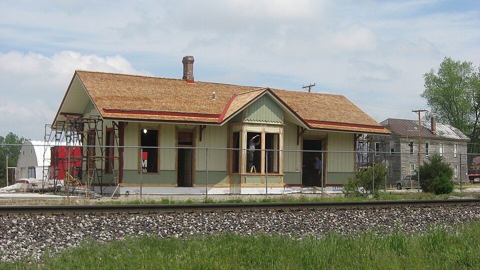
National Register reference number.03000146- the number the National Park Service assigned this property when it was listed, and the key its nomination file is catalogued under at the National Archives.
The ground it stands on
8,526 words
The chapter on Adams Township in History of Allen County, Indiana., published 1880 names New Haven. This is what it says, exactly as the scans read.
Jesse Adams, William Caswell, Eliphalet Edmunds, Charles Weeks, Sr., | Charles Weeks, Jr., Martin Weeks, Israel Taylor, Philip Fall, and Capt. Hurst, all settled here in 1823. Mr. Adams came from Rochester, N. Y., and for many years was prominently identified with the history of this township. It was he who gave it its name, not, however, to perpetuate his own, but, according to his own statement, in honor of John Quincy Adams, of whom he was a great admirer. Later in life, Mr. Adams removed to Jefferson Township, where he died in 1S55. William Caswell and Charles Weeks, Sr., removed to the northern part of the county, in 1830, and settled in Perry Township. Henry Cooper came in 1824, and was equally prominent with his associates P the organization and early history of the township. Judge Wolcott also settled, late in 1824. John Rogers came from Preble County, Ohio, in December, 1825. He was then forty years of age, j and brought with him a large family, for whose sake he had sought a home in the Western wilds. They were all dependent upon him for their maintenance, and this fact stimulated him to the most tireless efforts in the preparation of his forest land for cultivation ; and the same is true of all who were associated with him in l -those days. The necessities of their loved ones was the talisman which brought about such glorious results in the redemption of the wilderness, and its transform¬ ation into a rich farming district. Mr. Rogers cleared a farm, upon which he I resided for a period of twenty-five years; then, in 1850, removed to New Haven, i where a home had been made for him by his children. Here, and at Fort Wayne, he passed the remainder of his days. He died September 15,1877. Only five of his children now survive, viz.: Dorcas, the wife of John Brown, of Kendallville, Ind.; Leonard M., now a resident of New Haven; Alanson A., residing at Fort Wayne; Orrin D., editor of the New Haven Palladium , and Helen M., widow of Amasa Bowers. Mr. Rogers filled various local offices during- his life, ^ notably those of Justice of the Peace, Towuship Treasurer, Assessor, and County : Commissioner. Jabez Rogers came with the family of his brother John, in 1825. i He was then an unmarried man, but married Miss Margaret Brown in 1835, and purchased and cleared a farm, upon which he resided until his decease, in 1845. Early in 1S26 came Samuel Brown and John McIntosh, from Montgomery County, Ohio. Both cleared and improved large farms, upon which they resided until death. In 1827, John Blakely, from Shelby County, Ohio, rented the land of Absalom Holcomb, a portion of which he cleared and improved. Several years later, he purchased and moved to a tract of land in the adjoining township of Jef¬ ferson, and finally removed to Noble County, Ind., where he died. He, with Jabez Rogers and Benjamin H. Rogers, was associated with the surveying party who ran the experimental line for the Wabash & Erie Canal, from Fort Wayne. John K. Senseny, Joseph Townsend, David W. and Abraham Miller, Thomas Daniels, John Troutner and Judge Nathan Coleman came to the township in 1827. Thomas Daniels was a bachelor, and a prominent man in the township. He filled the office of Justice of the Peace, as weil as other local offices. Judge Coleman .was also a prominent man, and served as Associate Judge and County | Commissioner. He also filled local offices in the township. In 1837, he removed to Marion Township, where he continued to reside until his decease. Henry Tilbury and Jeremiah Bateman came in 1828. Tilbury came from near Sidney, l
In 1827, Chauncy Charter, of Logansport, Ind., surveye'd the first road through the township. It was surveyed from Fort Wayne to a point just east of New Haven, and was known as the river road. It became a popular thor¬ oughfare, and was subsequently continued as far as Defiance, Ohio.
Regional context, not property-specific
evidence. The
federal wildfire occurrence database
lists 1 fire within 5 miles of Wabash Railroad Depot
in 2006, burning about 50 acres in total. None started naturally. None was recorded as arson.
Distance is straight-line from the map coordinates, so a fire counted
here may appear on a neighbouring settlement's page as well.
Reported cause
Fires
Missing data/not specified/undetermined
1
The most recent of
them, most recent first, with the day each was reported and the service
that recorded it.
Regional context, not property-specific
evidence. The federal mineral resources record lists
1 working within 5 miles of Wabash Railroad Depot: 1 past producer.
None of them still produces. What was taken out: Sand and Gravel, Construction. Distance is straight-line from the
map coordinates, so a quarry counted here may appear on a neighbouring
settlement's page as well.
Regional context, not property-specific
evidence. The National Weather Service names
New Haven, the town this property stands in, in 24 storm reports between 1993 and 2022: 14 thunderstorm wind, 7 hail, 1 tornado, 1 flash flood.
No death or injury is recorded in these reports. Each account below is quoted exactly as the forecast office
filed it, from the NOAA Storm Events Database, and each date
opens the federal record of that event.
Lightning appears to have started a detached garage fire in the 1300 block of Baywood drive. This fire spread rapidly to two adjacent houses. The garage was a total loss, with one home suffering severe damage and the other moderate damage. No specific damage estimates were given, but will be assessed at $100,000.
Numerous trees were blown down from northeast of New Haven to the Woodburn area. Reports of corn fields being flattened just north of Woodburn were also received.
No historic map-sheet match is published
for this property yet. That does not mean no map exists. This record needs
a coordinate-quality review before it can be joined to a sheet boundary.
Browse the county's mapped places while that work is
pending.
Listed places nearby
6 within 8 miles
Other National Register properties close
enough to walk or drive between, ordered by distance from this one. Both
positions come from the same geocoding pass that matched these properties
to their map sheets.
Listing record. National Park Service National Register of Historic Places, listed-properties dataset, current to 2026-05-22.
Map join. Address geocoded through the United States Census geocoder, then tested against the published boundary of every sheet in the USGS Historical Topographic Map Collection.
How this page is made. Listing fields come from federal records; map-sheet coverage is a labelled coordinate-to-boundary calculation, not a source-field claim.
Wildfire. Short, Karen C. 2022. Spatial wildfire occurrence data for the United States, 1992-2020 [FPA_FOD_20221014]. 6th Edition. Fort Collins, CO: Forest Service Research Data Archive. https://doi.org/10.2737/RDS-2013-0009.6 Collected with United States Government funding and usable without additional permissions or fees.
Mines and quarries. USGS Mineral Resources Data System (MRDS) https://mrdata.usgs.gov/mrds/ A work of the United States government, no copyright under 17 U.S.C. 105.
Storms. NOAA National Centers for Environmental Information, Storm Events Database https://www.ncei.noaa.gov/stormevents/ A work of the United States government, no copyright under 17 U.S.C. 105. Narratives are quoted verbatim from the National Weather Service report and are not edited or summarised.
 Block