BlockBefore
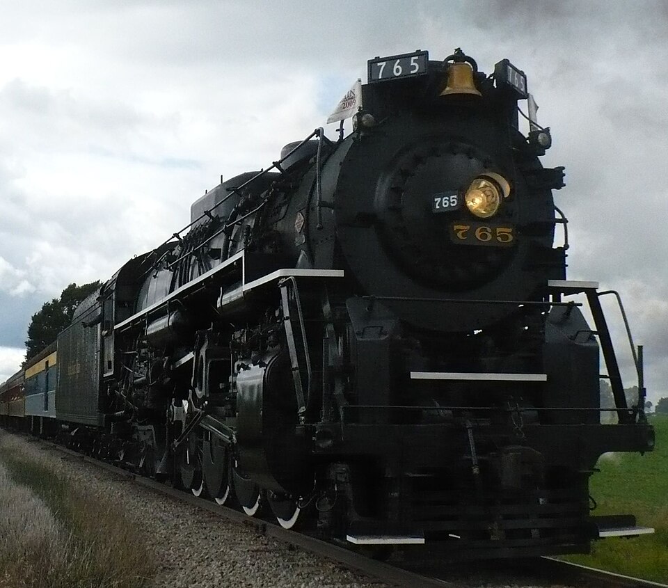
Photograph of Nickel Plate Road 765
Photograph by joneau261, Public domain. Via Wikimedia Commons.

New York Chicago and St. Louis Railroad Steam Locomotive No. 765

Listed on the National Register of Historic Places in 1996.

From the record

“Nickel Plate Road 765 is a preserved S-2 class 2-8-4 "Berkshire" type steam locomotive, built in September 1944 by the Lima Locomotive Works (LLW) for the New York, Chicago & St. Louis Railroad, commonly referred to as the "Nickel Plate Road".”

Wikipedia article Nickel Plate Road 765, CC BY-SA 4.0.

One of 81 National Register listings published here for Allen County · listed in 1996 · category: Structure.

Sources: the Wikipedia article · the case file at the National Archives · the National Register database, National Park Service

The listing

  • What is counted as historic. The nomination lists 1 structure as contributing to the listing.
  • Address. 15808 Edgerton Rd., New Haven, 46774
  • When was it listed? September 1996
  • Category. structure
  • Township. Jefferson township
  • National Register reference number. 96001010 - the number the National Park Service assigned this property when it was listed, and the key its nomination file is catalogued under at the National Archives.

The ground it stands on

3,124 words

The chapter on Jefferson Township in History of Allen County, Indiana., published 1880; Valley of the Upper Maumee River, with Historical Account of Allen County and the City of Fort Wayne, Indiana, published 1889 names New Haven. This is what it says, exactly as the scans read.

Flat Rock Lodge , No. JJJ, 1. 0. 0. I1., was instituted March 5, 1874, by P. G. M. Platt J. Wise, assisted by L. M. Rogers, of New Haven, and several members of the Lodges of Fort Wayne. The petition for dispensation was made February 4. 1874. and signed by Melancthon Cary, John C. Wilson, James E. Whitney, Eli Todd, J. R. Parker, Fred L. Gable, Fred Fry, H. D. Stoneman and A. C. Crawford.

Passage source: History of Allen County, Indiana., published 1880.

It is believed that the first permanent settlement within the limits of this township was made by Jared Whitney and his family. He came in May, 1833, and remained during the summer on the Maumee river, but in the fall took possession of a tract on section 7, which he afterward brought into cultivation. In the summer of the same year, Wilhelm and Henry Tuschknagen and families settled, and became industrious and esteemed citizens. But several years later, one of the sons, while at Fort Wayne, took a piece of cloth from a store and was arrested. One of the neighbors becoming bail, the culprit was released, and returned home, but a few days before the day of trial disappeared forever. The disgrace so affected the famil}- that they were broken in spirit, and the ostracism by the community affected their reason. It is related that the elder men were to be heard night after night breaking stone in the woods, for the purpose, they said, of building a temple. The last survivor was a mental wreck, was known as the "Prophet," and fancied he was divinely directed in every action. During 1S33 there also came Christian Wolf, Joseph Grunauer, Mr. Blackmore, a transient resident, William Henderson, Simon Rogers. The latter sold his clearing to Eben Burgess, who took possession in 1834. On this farm the first frame house was erected by one Blakel}^ and was used as a barn by Mr. Burgess, who erected the first brick house in 1S37. WilHam Henderson was married in March, 1835, to EHzabeth Rogers, the first ceremonj' of the kind in the township. In 1835 the first death occurred, that of a child of Mr. Blackmore. In 1834 ^ settlement was made by Aretas Powers, who was born in New York in 1800. He brought with him his wife, Sarah Stilson, to whom he was married in 1828, and their children afterward increased in number to eleven. James Post came also in 1834, but \yas not a permanent settler. A sad event of that period was the loss of a little son of the latter. He strayed into the woods, and his bod}- was found by a party of neighbors many days later in Seven Mile creek. Mr. Powers was the first justice of the peace elected in 1840. In 1835 or 1S36, Henry Castleman setUed near the center of the township. They were famous hunters, and were known to bring at one load to Fort Wayne, on a home-made sled, forty saddles of venison. Henry Castleman is said to have killed 1,678 deer and twenty-three bears. A celebrated event of the early time was the clearing up the Sugar ridge or Vanwert road. On New Year's eve, 1837, about twenty residents went to a point near New Haven, provided with cooking utensils as well as axes, and began the work. The road had been merely a foot path before, but this winter's campaign made it a well-defined highway.

Passage source: Valley of the Upper Maumee River, with Historical Account of Allen County and the City of Fort Wayne, Indiana, published 1889.

Machine-read from a century-old scan, so expect the errors a machine makes: misspelled names, dropped words, stray characters.

Read the whole chapter on Jefferson Township - 3,124 words on its settlement, mills, schools and churches.

Mines and quarries near this property

3 within 5 miles

Regional context, not property-specific evidence. The federal mineral resources record lists 3 workings within 5 miles of New York Chicago and St. Louis Railroad Steam Locomotive No. 765: 2 producers, 1 past producer. 2 still produce. What was taken out: Stone, Crushed/Broken, Sand and Gravel, Construction. Distance is straight-line from the map coordinates, so a quarry counted here may appear on a neighbouring settlement's page as well.

Where SiteCommodity StatusRecorded
Nail Road PitSand and Gravel, ConstructionPast Producer
Edgerton QuarryStone, Crushed/BrokenProducer
Woodburn Stone Quarry & PlantStone, Crushed/BrokenProducer

Every working recorded in Allen County

Storms near this property

24 since 1993

Regional context, not property-specific evidence. The National Weather Service names New Haven, the town this property stands in, in 24 storm reports between 1993 and 2022: 14 thunderstorm wind, 7 hail, 1 tornado, 1 flash flood. No death or injury is recorded in these reports. Each account below is quoted exactly as the forecast office filed it, from the NOAA Storm Events Database, and each date opens the federal record of that event.

WhenEvent Place namedHarm What the report says
June 2009LightningNew Haven$100,000Lightning appears to have started a detached garage fire in the 1300 block of Baywood drive. This fire spread rapidly to two adjacent houses. The garage was a total loss, with one home suffering severe damage and the other moderate damage. No specific damage estimates were given, but will be assessed at $100,000.
April 1993Thunderstorm WindNew Haven$5,000A drive in movie screen that was scheduled for demolition was blown down.
March 2022Thunderstorm WindNew Haven-The public reported a door with framing flew into a car. The door was not rom the same property as the car.
July 2022Thunderstorm WindNew Haven-Damage to trees was reported via mPING.
July 2022Thunderstorm WindNew Haven-A large tree limb was broken. The limb did show some signs of rot.
June 2020Thunderstorm WindNew Haven-Trained spotter estimated 60 mph gusts based on numerous branches down.
May 2014Thunderstorm WindNew Haven-A trained spotter estimated wind gust to 60 mph.
November 2013Thunderstorm WindNew Haven-The public reported several trees down.
July 2010Thunderstorm WindNew Haven-A trained spotter reported a tree down onto a trailer. No information was available on damage.
June 2008Thunderstorm WindNew Haven-A local television station reported a large tree down in the town of New Haven.
June 2005Thunderstorm WindNew Haven-Numerous trees were blown down from northeast of New Haven to the Woodburn area. Reports of corn fields being flattened just north of Woodburn were also received.
July 2005Thunderstorm WindNew Haven-Trees were blown down in the area.
June 2004Flash FloodNew Haven-Amateur radio reported stalled vehicles and flash flooding in New Haven.
July 1999Thunderstorm WindNew Haven-Power lines downed.
May 1998Tornado (F0)New Haven-BRIEF TOUCHDOWN ALONG ROUTE 30 AND LINCOLN HIGHWAY
February 2017HailNew Haven-no account filed
June 2010Thunderstorm WindNew Haven-no account filed
August 2003HailNew Haven-no account filed
July 2003HailNew Haven-no account filed
May 2002HailNew Haven-no account filed
June 2002HailNew Haven-no account filed
May 2000HailNew Haven-no account filed
May 1998HailNew Haven-no account filed

Every storm recorded in Allen County

Map coverage status

No historic map-sheet match is published for this property yet. That does not mean no map exists. This record needs a coordinate-quality review before it can be joined to a sheet boundary. Browse the county's mapped places while that work is pending.

Listed places nearby

4 within 8 miles

Other National Register properties close enough to walk or drive between, ordered by distance from this one. Both positions come from the same geocoding pass that matched these properties to their map sheets.

Photograph PropertyDistance Listed
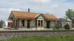
Craigville Depot1.4 miles1984
Besancon St. Louis Historic District2.6 miles1995
Wabash Railroad Depot4.6 miles2003
Martin Blume Jr. Farm7.9 miles2006

Sources for this property

National Archives recordThe nomination case file for reference 96001010 in Record Group 79.
Wikipedia articleCommunity-written account of this property, licensed CC BY-SA.
Allen CountyAll 81 listed properties in this county.

Provenance

  • Listing record. National Park Service National Register of Historic Places, listed-properties dataset, current to 2026-05-22.
  • Map join. Address geocoded through the United States Census geocoder, then tested against the published boundary of every sheet in the USGS Historical Topographic Map Collection.
  • How this page is made. Listing fields come from federal records; map-sheet coverage is a labelled coordinate-to-boundary calculation, not a source-field claim.
  • Mines and quarries. USGS Mineral Resources Data System (MRDS) https://mrdata.usgs.gov/mrds/ A work of the United States government, no copyright under 17 U.S.C. 105.
  • Storms. NOAA National Centers for Environmental Information, Storm Events Database https://www.ncei.noaa.gov/stormevents/ A work of the United States government, no copyright under 17 U.S.C. 105. Narratives are quoted verbatim from the National Weather Service report and are not edited or summarised.