Listed on the National Register of Historic Places in 2004.
From the record
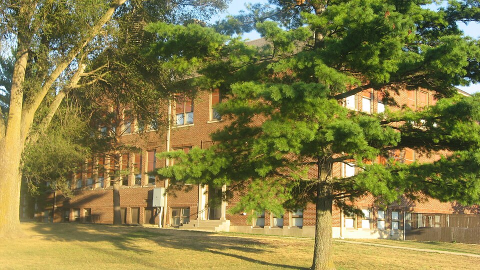
“Center Township Grade and High School, also known as Mays Elementary School, is a historic school building located at Rushville, Indiana. It was built in 1929, and is a brick building with Classical Revival and Prairie School style design elements.”
Wikipedia article Center Township Grade and High School, CC BY-SA 4.0.
One of 28 National Register listings published here for Rush County · listed in 2004 · category: Building.
Also known as. Indiana's Public Common and High Schools MPS
Township. Center township
National Register reference number.04000211- the number the National Park Service assigned this property when it was listed, and the key its nomination file is catalogued under at the National Archives.
John W. Martin, merchant and grocer of Mays, was born in Chester County, Pa., February 16, 1837. He was the son of Major Benjamin L. and Sarah (Christmanj Martin, who were also natives of Chester Count}-, Pa. His father served as a Major during the late war. He was the son of John and Ruth Ann (Stevenson) Martin, who also were natives of Pennsylvania. When he was two years old his parents settled in Wavne County, this State, Avhere our subject was reared and where his parents still reside. The father, B. L. Martin, served as Auditor of Wayne County, from 1S53 to 1S61, and during the greater part of that time our subject was his deputy. In the meantime he had provided himself with a collegiate education, having spent six years in Whitewater College of Centerville. In 1861 he resigned the deputy auditorship to accept the position as deputy Secretary of State under Judge William A. Peelle. At the end of two years he entered the service of the Union Army and served in a creditable manner until the close of the war. On retiring from the service, he returned home and he was married in Aurora, this State, to Jennie J. Jones in the fall of 1866. She was born in Aurora, Ind., being the daughter of Jonathan and Sophia Jones. Shortlv after his marriage Air. Martin went to Grenada, Miss., where he was engaged in merchandising two years. He then returned to Wa^-ne County; Ind., and two 3'ears later he engaged in mercantile pursuits in Chester and Bethel, both of Wayne County. In about 1S76 he entered the employ of the Maddux Bros, of Cincinnati as traveling salesman, in which capacity he continued three }-ears. He then came to Rush County and engaged in merchandising in Raleigh, and also farming in the vicinity of that place. He continued in this way six years. By this time his health was serious!}- impaired and he retired from business and spent one 3-ear recruiting it. February i, 1887, he opened a general store in Ma}-s, this county, to which his attention is now directed. He is the father of four children, Stella A., Inez S., Alice Blanche and Jessie, all living. Mrs. Martin is a member of the Church. Mr. Martin is a member of the Masonic fraternitv and a Republican in politics. While a resident of Wayne County he served as Justice of the Peace one term. He is an intelligent man with good business qualifications and a first class citizen. His father is also an ardent Republican and has represented Wajme County, this State, two terms in the State Legislature.
Regional context, not property-specific
evidence. The federal mineral resources record lists
1 working within 5 miles of Center Township Grade and High School: 1 producer.
All of them still produce. What was taken out: Sand and Gravel, Construction. Distance is straight-line from the
map coordinates, so a quarry counted here may appear on a neighbouring
settlement's page as well.
Regional context, not property-specific
evidence. The National Weather Service names
Mays, the town this property stands in, in 6 storm reports between 1996 and 2021: 4 thunderstorm wind, 1 tornado, 1 hail.
No death or injury is recorded in these reports. Each account below is quoted exactly as the forecast office
filed it, from the NOAA Storm Events Database, and each date
opens the federal record of that event.
A weak tornado touched down in Rush County on the evening of 28 August 2006. The tornado was observed by the representatives of the county emergency management agency and sheriff's department. Two homes sustained minor roof damage and several small outbuildings were damaged or destroyed. Some corn was destroyed as well.
Several trees and power lines were downed, as well as damage to a barn, east of County Road 150 East on County Road 900 North due to damaging thunderstorm wind gusts. The damage appeared to be from straight-line winds and was relayed by law enforcement.
No historic map-sheet match is published
for this property yet. That does not mean no map exists. This record needs
a coordinate-quality review before it can be joined to a sheet boundary.
Browse the county's mapped places while that work is
pending.
Listed places nearby
6 within 8 miles
Other National Register properties close
enough to walk or drive between, ordered by distance from this one. Both
positions come from the same geocoding pass that matched these properties
to their map sheets.
Listing record. National Park Service National Register of Historic Places, listed-properties dataset, current to 2026-05-22.
Map join. Address geocoded through the United States Census geocoder, then tested against the published boundary of every sheet in the USGS Historical Topographic Map Collection.
How this page is made. Listing fields come from federal records; map-sheet coverage is a labelled coordinate-to-boundary calculation, not a source-field claim.
Mines and quarries. USGS Mineral Resources Data System (MRDS) https://mrdata.usgs.gov/mrds/ A work of the United States government, no copyright under 17 U.S.C. 105.
Storms. NOAA National Centers for Environmental Information, Storm Events Database https://www.ncei.noaa.gov/stormevents/ A work of the United States government, no copyright under 17 U.S.C. 105. Narratives are quoted verbatim from the National Weather Service report and are not edited or summarised.
 Block