| July 1980 | Tornado (F4) | not stated | 2 killed, 25 hurt, $2,500,000 | no account filed |
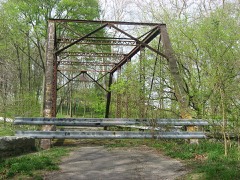
| June 2008 | Tornado (EF3) | Moscow | 1 killed, 8 hurt, $1,000,000 | The tornado touched down in Shelby County at 2004 EST 200 meters north of the County Road South 500 East and County Road East 500 South intersection. The tornado tracked to the east northeast for 2.93 miles before entering Rush County at 2012 EST near County Road South 1000 West just south of County Road East 450 South. The tornado continued to the northeast for 6.75 miles until lifting at 2030 EST. The tornado lifted 200 meters east of County Road South 400 West and 400 meters north of West State Road 244. The tornado was on the ground for a total of 9.68 miles and 26 minutes. The tornado was an EF-0 with wind speeds around 75 miles per hour while in Shelby County, however intensified to an EF-3 tornado while in Rush County with wind speeds around 150 miles per hour. The tornado had a width of 150 yards. The tornado formed from a supercell storm. While in Shelby County the tornado damaged 34 structures with the hardest hit areas being Middletown and Waldron. 27 of the damaged structures were in Middletown with 4 of these being completely destroyed. Trees and powerlines were also blown down and a semi-trailer was blown off Interstate 74. In Rush County 8 people were injured including a man and a woman who were pinned beneath a wall in Moscow. A 67 year old woman in Moscow was injured from a large tree limb that impaled her in the chest and later passed away due to those injuries on August 17th. The historic Moscow Covered Bridge was destroyed in addition to extensive damage to the Moscow school. Dozens of houses were severely damaged or destroyed including some houses that were swept completely off the foundation. Approximately 200,000 dollars in damage occurred in Shelby County and approximately one million dollars in damage occurred in Rush County. |
| April 1961 | Tornado (F4) | not stated | 3 hurt, $2,500,000 | no account filed |
| March 2025 | Thunderstorm Wind | Rushville | 3 hurt, $500,000 | Thunderstorm winds caused damage over 50 locations across Rush County with trees or powerlines down and at least two dozen structures damaged. Three people were injured north of Rushville where winds blew over a security trailer. |
| June 2023 | Thunderstorm Wind | Williamstown | 1 hurt, $50,000 | Tree downed by thunderstorm wind gusts onto a car with one injury reported. |
| June 1980 | Tornado (F0) | not stated | 1 hurt | no account filed |
| September 2002 | Tornado (F0) | Rushville | $500,000 | A tornado formed along a squall line. Two mobile homes and two barns were destroyed. |
| June 2019 | Tornado (EF2) | Gowdy | $275,000 | The EF-2 rated tornado, with max wind speeds of 130 mph, began near the intersection of County Road 400 South and 550 West and tracked northeast. The worst damage was located just southwest of Rushville along County Road 300 South and Flatrock River Road. Two metal silos and a barn were destroyed at a property near the intersection and debris from these structures were twisted and carried one half to three quarters of a mile to the northeast. An extensive amount of trees were sheared and uprooted along Flatrock River Road.||Additional damage occurred to trailers parked at the Fraley and Schilling Trucking Company along State Route 3 just south of Rushville. The last area of significant damage occurred at a home along Orange Pike to the east-southeast of Rushville. Numerous trees were snapped and a detached and well anchored garage was completely destroyed.||Tree damage continued to the northeast of this point...crossing State Route 44 west of Glenwood before ending north of Glenwood near County Road 250 North. |
| June 2021 | Flash Flood | Richland | $250,000 | Rapidly flowing water over State Road 244 in southern Rush county. A section of County Road 1000 South was washed out by flood waters. |
| November 1992 | Tornado (F2) | not stated | $250,000 | no account filed |
| June 1992 | Tornado (F1) | not stated | $250,000 | no account filed |
| September 2022 | Thunderstorm Wind | Circleville | $200,000 | Thunderstorm downburst winds blew down trees through the town of Rushville and along the south side of town...damaging 6 homes, including partial roof damage to a building on the southwest side of Rushville. Winds continued to down trees and powerlines to the southeast side of Rushville. |
| June 2022 | Tornado (EF1) | Arlington | $185,000 | NWS survey confirmed EF1 tornado tracked from 4.75 miles east-southeast of Morristown to 3.4 miles north of Rushville. Tornado first caused damage around the intersection of County Roads West 200 North and North 900 West. Four homes sustained damage that consisted primarily of roof and siding taken off homes. South facing front porch roof taken off western most house. Clear convergent pattern was observed in this area with several large tree limbs down and a few smaller trees topped or uprooted. Sheet metal was thrown nearly a quarter mile east. A storage shed was lifted and moved 40 feet off of its foundation. Siding and roof loss occurred at 3 other homes at this location. The Tornado likely lifted briefly over a large field but then hit the Posey Township Volunteer Fire Department station on US Highway 52 where the south side of the roof was torn off and debris lofted several hundred yards to the northeast. Trees to the west of this building were broken off near their tops. The tornado then continued skipping to the east per law enforcement observations and witnesses. Minor damage was observed at a school on the north side of Arlington with soffit/awning damage on west side of building. That metal was deposited to the north while small trees and limbs along a north side fence line were laid down to the south. From this point on to ending point, witnesses reported the tornado lifting and dropping across fields with only sporadic tree damage. Law enforcement reported the tornado lifted for final time along County Road 300 North, just east of Indiana Route 3 and West of County Road 150 West. |
| March 2026 | Thunderstorm Wind | Manilla | $150,000 | Numerous trees and power lines downed across a swath stretching from Manilla to near Arlington. |
| April 2025 | Thunderstorm Wind | Richland | $150,000 | Five power poles and a tree downed on 450 east. Nearby there was a swath of damage from 950 East to 700 East and from 1000 South to 900 South where 4 structures were damaged including one large utility barn. |
| July 2022 | Thunderstorm Wind | Rushville | $125,000 | Thunderstorm downburst winds snapped or uprooted trees from Rush County Fairgrounds across northern and northeastern portions of Rushville. Falling trees damaged 4 vehicles and 2 homes. Winds downed tents, trailers awnings and tables at the Rush County Fair, leading to flying debris that possibly caused injuries. The top half of a communication tower was bent over and onto the Rushville Police Department. Another tree was downed at 815 East 11th Street. |
| April 2020 | Thunderstorm Wind | Raleigh | $100,000 | A barn was destroyed due to thunderstorm wind gusts at this location. In addition, corn stalks completely covered a nearby fence. There was significant tree damage at several residences nearby with large trees snapped. |
| July 2021 | Thunderstorm Wind | Rushville | $75,000 | Significant roof and side wall damage to a house and outbuilding due to a microburst. |
| May 2002 | Flash Flood | Countywide | $75,000 | no account filed |
| March 2025 | Thunderstorm Wind | Rushville | $50,000 | Trees downed by thunderstorm wind gusts which knocked out power for much of the town. |
| April 2025 | Flash Flood | Gowdy | $50,000 | Many sections of Rushville were impassable due to flooding. Several streams nearby had near record flooding. Total rainfall ranged from 2.7 to 3.1 inches. |
| August 2022 | Thunderstorm Wind | Sexton | $50,000 | Multiple trees downed by thunderstorm wind gusts at 2 nearby homes. At one home the roof was partially lifted. A shed was also blown into a nearby field with the large lawnmower pushed downwind. |
| July 2021 | Thunderstorm Wind | Homer | $50,000 | Pole barn damaged by a microburst within an area of strong thunderstorm winds. An old corn crib was also destroyed at this location. |
| June 2020 | Thunderstorm Wind | Circleville | $50,000 | A survey conducted by the NWS determined that a microburst caused significant damage to portions of Rushville. Several utility poles were snapped or bent. A small communications tower was bent at the joint as well as several large trees either uprooted or snapped near the base. |
| April 2020 | Thunderstorm Wind | Rushville | $50,000 | A measured thunderstorm wind gust at this location. Reports received of significant tree damage across town and in nearby communities. |
| December 2015 | Thunderstorm Wind | Rushville | $50,000 | Houses were damaged, trees were downed, and there were power outages in Rushville due to damaging thunderstorm wind gusts. |
| August 2006 | Tornado (F0) | Mays | $50,000 | A weak tornado touched down in Rush County on the evening of 28 August 2006. The tornado was observed by the representatives of the county emergency management agency and sheriff's department. Two homes sustained minor roof damage and several small outbuildings were damaged or destroyed. Some corn was destroyed as well. |
| November 2004 | Tornado (F1) | Rushville | $50,000 | A small tornado touched down just west of the Rush/Franklin county line, moving into Franklin county, and out of the Indianapolis County Warning Area, at 5:27 pm EST. A garage was destroyed and numerous trees and a power pole were snapped. At US 52 just west of the county line, a home lost part of its roof. Property damage is estimated. |
| April 1994 | Thunderstorm Wind | not stated | $50,000 | Thunderstorm winds rolled over a mobile home and threw a basketball hoop through a garage door just east of Rushville. A barn and several trees were blown down near Moscow. |
| May 2002 | Flash Flood | Countywide | $50,000 | no account filed |
| May 2024 | Tornado (EF1) | Moscow | $47,000 | This third of five central Indiana tornadoes tracked slightly north of east, from 0.6 miles north of Rush County's southwest corner to 0.4 miles west of the intersection of County Roads 1000 South and 500 West. ||Damage was mostly to trees and a couple barn roofs. The tornado touched down just northeast of the intersection of County Roads 1050 South and 1000 West, snapping several healthy softwood pine trees about 8-10 feet above ground, while nearby homes only sustained minor damage to siding; although a portion of a barn's metal roof was ripped back and blown off, thrown to the east-southeast. Northwest of the intersection of County Roads 875 West and 1050 South, several large tree branches were broken off by the northern edge of the tornado's vortex where a corn field met a wooded area. Towards the track's midpoint, a low-sloped barn roof, just west of South Degelow Road, had almost half of its metal ripped back, before further tree damage and a utility pole were downed at a homestead just west of County Road 775 West; a witness at this location saw the vortex before it became rain wrapped. Towards the end of the damage path, further minor tree damage with many downed tree limbs occurred along South River Road and the adjacent Flatrock River, before the tornado ended about 0.5 miles later while tracking along County Road 1000 South.||The parent supercell's rear flank downdraft inflow winds also approached 80 mph, as indicated by periphery damage about 0.25 miles south of the convergent tornadic damage at County Road 775 West, as well as at South River Road where the wide damage path included weak convergence through the wooded area where the tornado tracked. This was the longest-tracking and most destructive tornado of the episode in central Indiana, although all damage was EF0 intensity following the peak intensity of 110 mph winds (EF1) at the tornado's onset. |
| August 2018 | Thunderstorm Wind | Gings | $40,000 | A survey team found large swaths of corn damage through Rush County. Numerous trees were knocked down. Northeast of Rushville a large camper was rolled over twice coming to rest on the side of an adjacent home.||A few storage sheds were damaged, including one that was destroyed as it was blown approximately 100 yards.||The damage across the county was indicative of straight line thunderstorm wind damage, due to a downburst or collapsing thunderstorm. |
| March 2023 | Thunderstorm Wind | Carthage | $35,000 | Thunderstorm winds downed trees throughout Rush County, including one onto an unoccupied vehicle in Carthage. |
| March 2026 | Thunderstorm Wind | Mauzy | $30,000 | Thunderstorm wind gusts downed multiple trees and powerlines. |
| May 2024 | Tornado (EF1) | Moscow | $30,000 | This fourth of five central Indiana tornadoes tracked to the east-northeast, from northeast of the intersection with South Prill Road and South Degelow Road to south-southwest of the intersection of South Prill Road and County Road 740 West. Despite tracking for only 850 feet, the circulation was strong enough to completely destroy a metal barn; although grain silos immediately west and a nearby home to the northwest were both untouched. The barn had rusted connections between the toe nail of frame and foundation. The barn's debris were thrown to the northeast, north and northwest before the tornado quickly dissipated in a field to the east. Peak winds were 110 mph. |
| September 2013 | Thunderstorm Wind | Rushville | $30,000 | A large tree fell on a house in Rushville due to damaging thunderstorm wind gusts. Several other trees were uprooted in the area, along with damage to two homes and one apartment complex. Numerous power outages were reported. |
| July 2017 | Thunderstorm Wind | Rushville | $27,000 | The Rush County Emergency Manager reports trees down across Rushville due to damaging thunderstorm wind gusts. There were also reports of damage to homes and power lines being down. |
| July 2023 | Thunderstorm Wind | Rushville | $25,000 | Tree downed onto occupied car by thunderstorm wind gusts. |
| May 2022 | Thunderstorm Wind | Moscow | $25,000 | Thunderstorm wind gust destroyed a garage, approximately 30 by 50 feet, due to lack of significant anchoring on garage walls, and the garage door facing the wind was compromised. Two other nearby barns sustained roof loss but homes between had no damage. Debris was thrown about 20 yards to east. Little if any debris was lofted into nearby woods where no trees were down. |
| June 2009 | Lightning | Rushville | $25,000 | The Rushville Republican reported a church office fire was started due to lightning from an isolated afternoon thunderstorm. The United Methodist Church District Office building sustained water damage to the kitchen, utility room, and bathroom, as well as minor smoke damage throughout. A hole, roughly a foot in diameter, was located on the northwest side of the roof. No injuries were reported. |
| May 1986 | Tornado (F1) | not stated | $25,000 | no account filed |
| July 1980 | Tornado (F4) | not stated | $25,000 | no account filed |
| July 2023 | Thunderstorm Wind | New Salem | $20,000 | Thunderstorm winds downed power lines with a fire at 2627 South County Road 675 East. |
| August 2021 | Thunderstorm Wind | Falmouth | $20,000 | Trees reported down near Fairview with some falling onto cars and possibly on houses with possible damage to homes. All damage appeared to be from straight line winds. Trees were blown over in one direction from Bentonville into NW Rush County. |
| April 2015 | Thunderstorm Wind | Rushville | $20,000 | There were multiple reports of trees down, building damage, and power lines down around Rushville and northern parts of the county due to damaging thunderstorm wind gusts. Three fourths of Rushville was reported to be without power. |
| October 2013 | Thunderstorm Wind | Rushville | $20,000 | Some farm equipment was damaged west of Rushville due to damaging thunderstorm wind gusts. Trees were also reported down around Rush County. |
| March 2008 | Flood | Raleigh | $20,000 | Heavy rains caused flooding of several roads across Rush County. |
| July 2008 | Thunderstorm Wind | Rushville | $18,000 | Trees, being blown down by thunderstorm winds, were responsible for downed power and phone lines. Downed trees also closed a number of city streets. One of the most extensively damaged areas was in the 1000 block of North Harrison Street. Multiple trees were downed, with one falling on a residence. The tree caused extensive damage to the rear of the single-story residence. Two blocks north, a number of downed trees forced the closure of Park Boulevard from 13th Street to Main Street. The 500 and 600 blocks of Harrison Street were reduced to a single lane and eventually closed to any traffic. An 80-foot pine tree was uprooted in the 1200 block of Washington Street, struck a transformer and resulted in a 12-hour power outage in the area. |
| June 2025 | Thunderstorm Wind | Rushville | $15,000 | Thunderstorm wind gusts downed a tree onto a house. No injuries occurred. Multiple trees and power lines down across the county. |
| July 2023 | Thunderstorm Wind | Rushville | $15,000 | Thunderstorm winds downed a tree onto a power line and transformer on Indiana Route 44 at 235 West. |
| June 2020 | Thunderstorm Wind | Howell Brothers Arpt | $15,000 | Trees of unknown size downed and blocking road due to thunderstorm wind gusts. |
| February 2019 | Flash Flood | Falmouth | $15,000 | Indiana Conservation Officers performed a water rescue to save 3 people trapped along County Road 700 North due to flash flooding from heavy rainfall. |
| June 2019 | Thunderstorm Wind | New Salem | $15,000 | There were reports of trees down across the area and a roof torn off a small barn due to damaging thunderstorm wind gusts. The Emergency Manager suggests that it is all from straight line winds. |
| June 2019 | Thunderstorm Wind | New Salem | $15,000 | Numerous trees were downed in southeast Rush County due to damaging thunderstorm wind gusts. |
| November 2017 | Flash Flood | Circleville | $15,000 | Four inches of rain was causing small streams to exceed their banks and water to enter a basement east of Rushville. |
| December 2015 | Thunderstorm Wind | Sexton | $15,000 | A pole barn was destroyed in this location due to damaging thunderstorm wind gusts. |
| May 2013 | Thunderstorm Wind | Rushville | $15,000 | Trees were reported down, with at least one down on a vehicle, due to damaging thunderstorm wind gusts. |
| August 2000 | Thunderstorm Wind | Rushville | $15,000 | no account filed |
| June 2018 | Thunderstorm Wind | Mays | $13,000 | Several trees and power lines were downed, as well as damage to a barn, east of County Road 150 East on County Road 900 North due to damaging thunderstorm wind gusts. The damage appeared to be from straight-line winds and was relayed by law enforcement. |
| February 2014 | Thunderstorm Wind | Arlington | $13,000 | There was barn damage north of Arlington due to damaging thunderstorm wind gusts. Numerous trees and power lines were also reported down in the area as well. |
 Block