BlockBefore
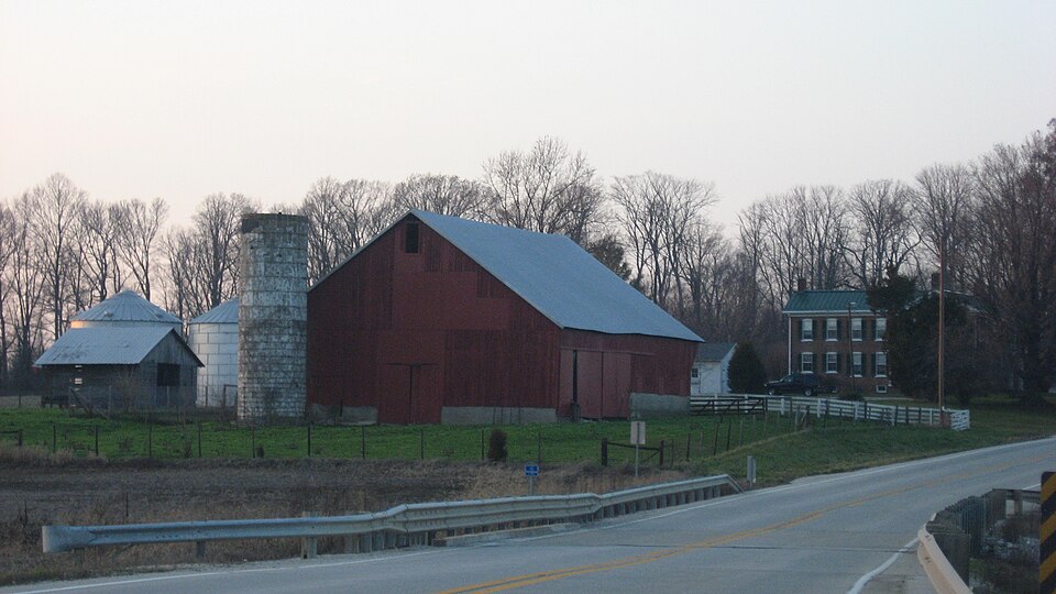
Photograph of Andrew Nicholson Farmstead
Photograph by Nyttend, Public domain. Via Wikimedia Commons.

Andrew Nicholson Farmstead

Listed on the National Register of Historic Places in 2005.

From the record

“Andrew Nicholson Farmstead is a historic home and farm located in Steen Township, Knox County, Indiana. The house was built in 1863, and is a two-story, five-bay, vernacular Greek Revival style brick I-house.”

Wikipedia article Andrew Nicholson Farmstead, CC BY-SA 4.0.

One of 19 National Register listings published here for Knox County · listed in 2005 · category: Building.

Sources: the Wikipedia article · the case file at the National Archives · the National Register database, National Park Service


The listing

  • Listed as. Nicholson, Andrew, Farmstead - the National Register files a house under its owner's surname.
  • Address. 12095 E IN 550, Wheatland, 47597
  • When was it listed? June 2005
  • Category. building
  • Township. Steen township
  • Architectural style. Greek Revival architecture
  • National Register reference number. 05000606 - the number the National Park Service assigned this property when it was listed, and the key its nomination file is catalogued under at the National Archives.

Storms near this property

19 since 1997

Regional context, not property-specific evidence. The National Weather Service names Wheatland, the town this property stands in, in 19 storm reports between 1997 and 2025: 14 thunderstorm wind, 3 flash flood, 1 flood, 1 hail. No death or injury is recorded in these reports. Each account below is quoted exactly as the forecast office filed it, from the NOAA Storm Events Database, and each date opens the federal record of that event.

WhenEvent Place namedHarm What the report says
June 2008FloodWheatland$8,000,000Flooding occurred along the White River in Knox County, including near the Petersburg, Hazleton, and Edwardsport areas, due to heavy rain and levee breaches. Levee unit 8 failed in the Smother's Creek area near Edwardsport. The levee breach failure caused the White River to crest at Edwardsport. More than 20,000 acres of Daviess County flooded as a result of the levee failure.
June 2008Flash FloodWheatland$100,000All four lanes of United States Highway 50 were under water due to heavy rainfall. Homes were flooded in Edwardsport. Water poured into the energy generating plant. Albert Street was flooded.
May 2003Thunderstorm WindWheatland$10,000no account filed
April 2012Thunderstorm WindWheatland$5,000Power outages were reported in this area due to trees and power lines down from damaging thunderstorm wind gusts.
May 2003Thunderstorm WindWheatland$5,000no account filed
April 2025Thunderstorm WindWheatland$2,000Tree downed by thunderstorm wind gusts onto Enley Road.
July 2013Thunderstorm WindWheatland$2,000Two pretty large trees were downed by damaging thunderstorm wind gusts at the intersection of North Railroad and Sycamore Streets.
January 2012Thunderstorm WindWheatland$1,750A tree and utility line were reported down at State Road 550 and Evans Road, just outside of Wheatland, due to damaging thunderstorm wind gusts.
July 2022Thunderstorm WindWheatland$1,000Tree downed by thunderstorm wind gusts.
September 2018Flash FloodWheatland$1,000High water was reported to be over County Road 550, near Marchino Road, due to heavy rainfall. This report was relayed by Knox County EMA.
September 2018Flash FloodWheatland$1,000The Emergency Manager reported high water over portions of State Road 550 between Bruceville and Wheatland.
October 2014Thunderstorm WindWheatland$1,000A tree was reported down on Bicknell Road near the intersection with Hall Road due to damaging thunderstorm wind gusts.
May 1998Thunderstorm WindWheatland$1,000no account filed
April 1997Thunderstorm WindWheatland$500no account filed
August 2007Thunderstorm WindWheatland-Numerous trees were down due to damaging thunderstorm winds.
May 2005Thunderstorm WindWheatland-Several six to ten inch diameter limbs were blown down.
May 2012HailWheatland-no account filed
July 2004Thunderstorm WindWheatland-no account filed
June 1999Thunderstorm WindWheatland-no account filed

Every storm recorded in Knox County

Map coverage status

No historic map-sheet match is published for this property yet. That does not mean no map exists. This record needs a coordinate-quality review before it can be joined to a sheet boundary. Browse the county's mapped places while that work is pending.

Listed places nearby

3 within 8 miles

Other National Register properties close enough to walk or drive between, ordered by distance from this one. Both positions come from the same geocoding pass that matched these properties to their map sheets.

Photograph PropertyDistance Listed
County Bridge #452.5 miles2006
Shadowwood5.9 miles2001
Enoco Coal Mine7.0 miles2010

Sources for this property

National Archives recordThe nomination case file for reference 05000606 in Record Group 79.
Wikipedia articleCommunity-written account of this property, licensed CC BY-SA.
Knox CountyAll 19 listed properties in this county.

Provenance

  • Listing record. National Park Service National Register of Historic Places, listed-properties dataset, current to 2026-05-22.
  • Map join. Address geocoded through the United States Census geocoder, then tested against the published boundary of every sheet in the USGS Historical Topographic Map Collection.
  • How this page is made. Listing fields come from federal records; map-sheet coverage is a labelled coordinate-to-boundary calculation, not a source-field claim.
  • Storms. NOAA National Centers for Environmental Information, Storm Events Database https://www.ncei.noaa.gov/stormevents/ A work of the United States government, no copyright under 17 U.S.C. 105. Narratives are quoted verbatim from the National Weather Service report and are not edited or summarised.