BlockBefore
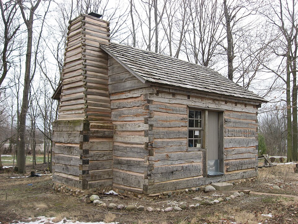
Photograph of George Boxley Cabin
Photograph by Nyttend, Public domain. Via Wikimedia Commons.

George Boxley Cabin

Built in 1828. Listed on the National Register of Historic Places in 2005.

From the record

One of 31 National Register listings published here for Hamilton County · listed in 2005 · category: Building · built in 1828.

Sources: the case file at the National Archives · the National Register database, National Park Service · the Wikipedia article

The listing

  • What is counted as historic. The nomination lists 1 building as contributing to the listing.
  • Listed as. Boxley, George, Cabin - the National Register files a house under its owner's surname.
  • Address. Pioneer Hill at First and Main Sts., Sheridan, 46069
  • When was it listed? September 2005
  • Category. building
  • Town. Sheridan town
  • When was it built? 1828
  • National Register reference number. 05001010 - the number the National Park Service assigned this property when it was listed, and the key its nomination file is catalogued under at the National Archives.

What happened here

An account from the chapter on Sheridan town. The inset identifies its exact source book and publication year.

From History of Hamilton County Indiana, published 1915 - Sheridan Town

Condensed Milk Factory

The Indiana Condensed Milk Company's plant at Sheridan is among the largest of its kind in the country. It was established about the year 1900 by W. N. Wilson, succeeding the old butter works that had been there many years before this latter organization. Mr. Wilson was accidentally killed by the explosion of a sterilizing equipment.

Read the rest of this passage

The ground it stands on

18,460 words

The chapter on Sheridan Town in History of Hamilton County Indiana, published 1915 names Sheridan. This is what it says, exactly as the scans read.

Sheridan, the second town in size in Hamilton county, is situated in the southwestern part of Adams township, on the Monon railroad connecting with Westfield, Carmel and Indianapolis to the south and Chicago to the north. The town was laid out in i860 by Egbert Higbee on the south side of the pike road running east and west. Higbee gave the town the name of Millwood. On the north side of the road, opposite Millwood, Caswell Boxlev laid out an addition to the town. Some years later, when application was made for a postoffice at this point, it was found that there already was a Millwood in the state, so the towns on both sides of the road were united under the one name, Sheridan.

Passage source: History of Hamilton County Indiana, published 1915.

The pioneer business men of Sheridan were P. G. Pearson, 1866, harness shop; Dr. H. Moore, general merchandise. In 1866 Egbert Higbee built the first flouring mill at Sheridan, but for some reason the mill was not, operated for two years. In 1868 three men, Cyrus Jessup, Eliel Jessup and J. P. Peason, went into partnership with Mr. Higbee and under their joint management the mill was put into operation for a short time. It then changed hands and finally was purchased by J. P. Peason and operated for years under the firm style of Peason & Son. In the early years a saw mill was operated in connection with the grist mill.

Passage source: History of Hamilton County Indiana, published 1915.

Machine-read from a century-old scan, so expect the errors a machine makes: misspelled names, dropped words, stray characters.

Read the whole chapter on Sheridan Town - 18,460 words on its settlement, mills, schools and churches.

Storms near this property

32 since 1995

Regional context, not property-specific evidence. The National Weather Service names Sheridan, the town this property stands in, in 32 storm reports between 1995 and 2023: 18 thunderstorm wind, 10 hail, 1 tornado, 1 lightning. The reports record 11 injuries. Each account below is quoted exactly as the forecast office filed it, from the NOAA Storm Events Database, and each date opens the federal record of that event.

WhenEvent Place namedHarm What the report says
June 2005LightningSheridan6 hurtSix people were struck by lightning at at paintball facility in Sheridan. Two were treated and released at the scene, with four being transported to area hospitals for treatment. The injuries were not serious.
June 2008Thunderstorm WindSheridan2 hurt, $50,000Ten buildings were damaged, numerous trees down, and two semi trucks blown over by thunderstorm winds. Injuries were reported but no exact number given. A barn was said to be destroyed by the thunderstorm winds, which was likely among the aforementioned damaged buildings.
July 1998Thunderstorm WindSheridan2 hurt, $5,000Thunderstorm winds blew down the second story of a building under construction injuring two.
June 2008Thunderstorm WindSheridan1 hurt, $50,000Damage was spread across the northern portion of Hamilton county. Most of the damage was in a line from Sheridan to Arcadia to Omega to Aroma then out of the county to the north-northeast. Trees of different diameters were downed. About 10 structures, most of them barns, had been damaged and trees blocked several roadways. In addition two semi tractor-trailers had blown over, one at 236th Street and US 31 causing personal injury and another at 281st Street and Indiana 213, in which a tree fell on top of a semi.
May 2000HailSheridan$5,000,000no account filed
June 1996Tornado (F1)Sheridan$40,000no account filed
May 2013Thunderstorm WindSheridan$10,000Multiple trees and power lines were reported down in this location due to damaging thunderstorm wind gusts.
April 2013FloodSheridan$10,000Residents reported their homes being surrounded by water due to thunderstorm heavy rainfall. This report was received via Facebook.
June 2008Thunderstorm WindSheridan$5,000A semi truck was blown over at SR 421 and SR 47.
June 1998Thunderstorm WindSheridan$3,000Trees and power lines blown down.
July 1997Thunderstorm WindSheridan$500Thunderstorm winds blew down a two and a half foot diameter tree just west of Sheridan on the Hamilton-Boone County line. Crops in the same vicinity were also damaged by the winds.
June 2023HailSheridan-Thunderstorm hail as large as tennis balls in and north of Sheridan.
March 2020HailSheridan-Report was relayed via Skywarn network.
June 2010Thunderstorm WindSheridan-A wind gust, measured at 67 mph, was observed in Sheridan.
June 2010Thunderstorm WindSheridan-A wind gust, measured at 75 mph, was observed in Sheridan on a Davis Weather Instruments meter.
May 2009Thunderstorm WindSheridan-Thunderstorm wind gusts were estimated to be at least 60 MPH. Dime size hail accompanied these winds.
February 2009Heavy RainSheridan-A storm total of 2.05 inches of rainfall was recorded. The event begin time is roughly estimated. This same observer also reported a 72 MPH wind gust on this day, as documented separately in this publication.
May 2006Thunderstorm WindSheridan-A large tree was downed.
August 2005Thunderstorm WindSheridan-A tree was downed and minor structural damage was caused to a home and a shed.
November 2005Thunderstorm WindSheridan-Tree limbs were broken along State Road 47.
November 2005Thunderstorm WindSheridan-Trees were downed.
June 1995Thunderstorm WindSheridan-Ten-inch-diamter healthy limbs blown down.
October 2010Thunderstorm WindSheridan-no account filed
March 2006HailSheridan-no account filed
April 2006HailSheridan-no account filed
May 2005HailSheridan-no account filed
April 2004HailSheridan-no account filed
September 2003HailSheridan-no account filed
March 2003HailSheridan-no account filed
December 1998Thunderstorm WindSheridan-no account filed
June 1996Thunderstorm WindSheridan-no account filed
June 1996HailSheridan-no account filed

Every storm recorded in Hamilton County

Map coverage status

No historic map-sheet match is published for this property yet. That does not mean no map exists. This record needs a coordinate-quality review before it can be joined to a sheet boundary. Browse the county's mapped places while that work is pending.

Listed places nearby

4 within 8 miles

Other National Register properties close enough to walk or drive between, ordered by distance from this one. Both positions come from the same geocoding pass that matched these properties to their map sheets.

Photograph PropertyDistance Listed
Davenport-Bradfield House0.2 miles1985
Sheridan Downtown Commercial Historic District0.3 miles2007
Roberts Chapel6.7 miles1996
Micajah Walden House7.5 miles2019

Sources for this property

National Archives recordThe nomination case file for reference 05001010 in Record Group 79.
Wikipedia articleCommunity-written account of this property, licensed CC BY-SA.
Hamilton CountyAll 31 listed properties in this county.

Provenance

  • Listing record. National Park Service National Register of Historic Places, listed-properties dataset, current to 2026-05-22.
  • Map join. Address geocoded through the United States Census geocoder, then tested against the published boundary of every sheet in the USGS Historical Topographic Map Collection.
  • How this page is made. Listing fields come from federal records; map-sheet coverage is a labelled coordinate-to-boundary calculation, not a source-field claim.
  • Storms. NOAA National Centers for Environmental Information, Storm Events Database https://www.ncei.noaa.gov/stormevents/ A work of the United States government, no copyright under 17 U.S.C. 105. Narratives are quoted verbatim from the National Weather Service report and are not edited or summarised.