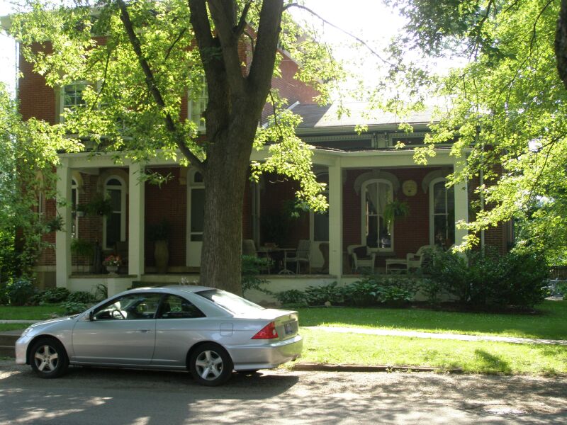
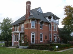
Listed on the National Register of Historic Places in 2007.
From the record
“Martin Young shows up in the abstracts of several significant real estate transactions that provided for the growth of the town of Chesterton. He does not appear to have had a major role in the development on the town, except it apparently provided him with the means to build the Italianate home on Second Street.”
Wikipedia article Martin Young House, CC BY-SA 4.0.
One of 42 National Register listings published here for Porter County · listed in 2007 · category: Building.
National Register reference number.07000208- the number the National Park Service assigned this property when it was listed, and the key its nomination file is catalogued under at the National Archives.
V isolated labor at the spinning wheel. After his release, he was compelled to join the Huzzars, but in about three days he deserted and went to Antwerp, where he was engaged as hotel porter, on account of ability to speak French and German, until he made enough to take him to America, three months later. He soon went to work on the Sault Ste. Marie Canal at Lake Superior, then soon to Detroit, Chicago, then to different places, and on steamers on Lake Michigan. In 1854, he began work for Hiram Joy, the Chicago ice king, remaining nine years, when he bought land near Chesterton ; for a year was in Chicago, also at Lake Superior, where he made considerable money. For some time, he was Deputy Sheriff in Houghton, Mich., near Lake Superior. He is the originator of the present brick-yards at New Porter. Since 1875, He has farmed. For four years before, he kept store at New Porter. He has been a member of the I. 0. 0. F. Lodge. Since 1876, he has been Justice of the Peace. He was married November 15, 1855, to Elizabeth Foederath, a German. She died exactly ten years after her marriage. In 1868, he married Theresa Kuhn, also a German. He has five children living. He is Independent in politics, a public-spirited citizen and a live business man.
Peterson left home and came to the United States, and settled in Chicago, and was engaged in building the early Chicago "plank streets." In a short time, he went to Aurora, 111., and learned and worked at upholstering for about three years. He then went to Lyons, Iowa, and established his business there, but failed, and as he was but nineteen years of age, and lost all, he shipped on a steamboat as " roustabout " to St. Louis, where he was without work and food for about three days, but soon got work near, on a farm, for all winter. He afterward bought a team, and began farming in Madison County, 111. After two years, he moved to Westchester Township, and began farming in Waverly, remaining there eleven years, when he bought his present farm of 209 acres of fine land, near Chesterton, on which he lives in a beautifully situated brick, nearly hidden by a fine grove. He has altogether about three hundred and thirty acres, indicating him to be a successful farmer and financier. He has been a member of the Swedish Lutheran Church. He has always been a Republican, bjit in local affairs is liberal. He was married, in 1861, to Christina S. Carlson, a native of Sweden. They have four children - Charles A., Ida B., Arthur 0. and Cora M. In 1863, he went to Sweden on business, and on the way there and back he visited and traveled through Norway, Germany, France, Denmark, all Great Britain and Ireland, to see the countries.
Regional context, not property-specific
evidence. The
federal wildfire occurrence database
lists 180 fires within 5 miles of Martin Young House
between 1992 and 2020, burning about 228 acres in total. 5 started naturally. 15 were recorded as arson.
Distance is straight-line from the map coordinates, so a fire counted
here may appear on a neighbouring settlement's page as well.
Reported cause
Fires
Missing data/not specified/undetermined
49
Debris and open burning
27
Railroad operations and maintenance
19
Power generation/transmission/distribution
18
Arson/incendiarism
15
Fireworks
11
Misuse of fire by a minor
10
Recreation and ceremony
9
Equipment and vehicle use
7
Other causes
5
Natural
5
Smoking
5
The most recent of
them, most recent first, with the day each was reported and the service
that recorded it.
Regional context, not property-specific
evidence. The federal mineral resources record lists
2 workings within 5 miles of Martin Young House: 2 past producers.
None of them still produces. What was taken out: Clay. Distance is straight-line from the
map coordinates, so a quarry counted here may appear on a neighbouring
settlement's page as well.
Regional context, not property-specific
evidence. The National Weather Service names
Chesterton, the town this property stands in, in 40 storm reports between 1993 and 2025: 22 thunderstorm wind, 9 hail, 6 lightning, 2 heavy rain.
No death or injury is recorded in these reports. Each account below is quoted exactly as the forecast office
filed it, from the NOAA Storm Events Database, and each date
opens the federal record of that event.
A tornado touched down in southern Chesterton east of 11th Street and southwest of South Park Drive. The tornado quickly intensified as it moved to the northeast and caused the partial collapse of a gymnasium roof at the Chesterton Junior High School. A wind gust to 105 mph was measured by an anemometer near the school. This damage along with numerous trees that were either uprooted or sheared off was caused by tornado winds reaching 110 mph. The tornado was rated EF1 at this point with a path width of 40 yards. The tornado continued to track to the northeast across the New York Central railroad tracks toward Grant Avenue where the roof of a warehouse had been peeled off and thrown about 15 yards behind the building to the north. The tornado continued to the northeast where an apartment building on Brown Avenue lost its entire roof. This damage was caused by tornado winds reaching 120 mph. The tornado damage was rated EF2 through this area with a path width of 60 yards. In the city of Chesterton, 211 structures sustained damage; 8 were completely destroyed; 54 suffered major damage, such as trees falling through roofs. The remaining 149 structures sustained damage such as missing shingles or damaged gutters. Multiple vehicles were damaged by falling debris from buildings or trees. Numerous power lines were blown down along with utility poles blown down or snapped. This EF2 damage continued northeast where an entire field of healthy old hardwood tree trunks were snapped off or uprooted. The tornado then started to slightly weaken as it approached the Interstate 94 eastbound exit/westbound entrance ramps at Indiana Highway 49. A home south of the interstate had a garage roof blown off with still numerous trees uprooted or sheared off. Tornado wind speeds here were estimated at 100 mph with an EF1 rating. Similar tree damage was noted along a path that continued to go to the northeast across Highway 49 and toward Highway 20 near Hadenfelt Road where some aluminum roofing material of a storage facility had been peeled off. Tornado wind speeds were estimated at 95 mph here and was rated EF1 with a path width of 30 yards. The tornado continued to move through a heavily forested area in the Indiana Dunes National Lakeshore, eventually crossing Highway 12. Radar imagery and an aerial survey suggests that the tornado dissipated north of Highway 12.
A bolt of lightning struck an apartment building during a thunderstorm early Saturday morning. It is suspected of starting a smoldering fire in the insulation in the attic which was finally noticed at 315 pm in the afternoon. Damage was estimated at $30,000 for the structure, mainly the roof, and $10,000 to contents in the building.
Lightning struck a tree, went down a security wire which was nailed to the tree, blew out wall sockets in a garage, traveled underground, blew out a light and a pump in a pool and finally struck a gas meter , but did not cause a fire.
Trees and power lines were blown down between Chesterton and Valparaiso. The front porch on a house in Valparaiso was destroyed when a tree fell on it. Several tents at the Porter County Fairgrounds also received wind damage.
No historic map-sheet match is published
for this property yet. That does not mean no map exists. This record needs
a coordinate-quality review before it can be joined to a sheet boundary.
Browse the county's mapped places while that work is
pending.
Listed places nearby
6 within 8 miles
Other National Register properties close
enough to walk or drive between, ordered by distance from this one. Both
positions come from the same geocoding pass that matched these properties
to their map sheets.
Listing record. National Park Service National Register of Historic Places, listed-properties dataset, current to 2026-05-22.
Map join. Address geocoded through the United States Census geocoder, then tested against the published boundary of every sheet in the USGS Historical Topographic Map Collection.
How this page is made. Listing fields come from federal records; map-sheet coverage is a labelled coordinate-to-boundary calculation, not a source-field claim.
Wildfire. Short, Karen C. 2022. Spatial wildfire occurrence data for the United States, 1992-2020 [FPA_FOD_20221014]. 6th Edition. Fort Collins, CO: Forest Service Research Data Archive. https://doi.org/10.2737/RDS-2013-0009.6 Collected with United States Government funding and usable without additional permissions or fees.
Mines and quarries. USGS Mineral Resources Data System (MRDS) https://mrdata.usgs.gov/mrds/ A work of the United States government, no copyright under 17 U.S.C. 105.
Storms. NOAA National Centers for Environmental Information, Storm Events Database https://www.ncei.noaa.gov/stormevents/ A work of the United States government, no copyright under 17 U.S.C. 105. Narratives are quoted verbatim from the National Weather Service report and are not edited or summarised.
 Block