BlockBefore
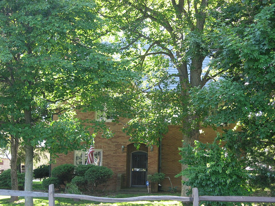
Photograph of Smith Farm
Photograph by Nyttend, Public domain. Via Wikimedia Commons.

Smith Farm

Listed on the National Register of Historic Places in 2007.

From the record

“Smith Farm, also known as the Smith-Grundy Farm, is a historic home and farm located in Washington Township, Hendricks County, Indiana. The farmhouse was built in 1928, and is a two-story, Tudor Revival style frame dwelling with a brick veneer.”

Wikipedia article Smith Farm (Plainfield, Indiana), CC BY-SA 4.0.

One of 22 National Register listings published here for Hendricks County · listed in 2007 · category: Building.

Sources: the Wikipedia article · the case file at the National Archives · the National Register database, National Park Service · the Wikipedia article

The listing

  • Listing status. The Park Service records this property as Removed.
  • What is counted as historic. The nomination lists 5 buildingss as contributing to the listing.
  • Address. 2698 S Cty.Rd. 900 E., Plainfield, 46168
  • When was it listed? December 2007
  • Category. building
  • Township. Washington township
  • National Register reference number. 07001279 - the number the National Park Service assigned this property when it was listed, and the key its nomination file is catalogued under at the National Archives.

The ground it stands on

9,569 words

The chapter on Washington Township in History of Hendricks County, Indiana, published 1885 names Plainfield. This is what it says, exactly as the scans read.

Clark Blair , County Commissioner of Hendricks County, Ind., was born near Stilesville, this county, March 25, 1836, a son of Lindsey and Rachel M. (Hodson) Blair. His father is one of the pioneers of this county, having come from North Carolina with his father, Solomon Blair, in 1820. His mother also came at a very early date with her father, Jesse Hodson, settling near Amo, in Clay Township. Our subject was reared near and in Plainfield and received most of his education in the schools of that place. 'His father died when he was seventeen years old, and he being the eld¬ est son was obliged to superintend the farm. Previous to his father's death he clerked two years in the drug store of Craighead & Brown¬ ing, in Indianapolis, Ind., after which, in the fall of 1852, he entered the Plainfield Academy, remaining there till his father died. Jan. 31, 1858, he was married to Marian Sanders, daughter of Benjamin and Lucinda Sanders, of Washington Township, who were among the first families of the county. His wife died in April, 1872, leav¬ ing four children - Benjamin L., traveling salesman fora wholesale house in San Francisco, Cal. ; Willet B., a farmer in Washington Township; Eddie E. and Flora Alice, still at home. He was again married, in May, 1873, to Miss Sarah M. Cox, of Guilfprd Town¬ ship, and to them have been born five children - Effie May, George I Porter, Mary E., Arthur A. and lues S. After his first marriage he left his home and settled on a farm in Washington Township, on which he lived but a shprt time, when he purchased the farm adjoining, where he has since followed agricultural pursuits. In October, 1876, he wa9 elected a Trustee of Washington Township, which office he held by re-election two terms. In the fall of 1880 hewas elected one of the Commissioners of this county and was i re-elected to serve another term. Mr. Blair is a Master Mason and has served as Secretary of Bridgeport Lodge, No. 162, A. F. & A. M., two years. He is a member of the Methodist Episcopal ! church, of which he has been Steward and Class-Leader a number of years. His wife is a member of the society of Friends.

Passage source: History of Hendricks County, Indiana, published 1885.

Enos Hadley, an influential and successful farmer and stock- j raiser of Washington Township, is a native of Hendricks County, born near Plainfield, June 10, 1825, a son of Jonathan and Ara ! Hadley. His parents came to Hendricks County in the fall of 1823, and entered eighty acres of Government land, which they began to improve and make a home. They were pfominent among the early settlers of the county, earnest members of the Christian church, and honored members of society. Their family consisted of nine children, but four of whom are living - Enos, Harlan, Will¬ iam C. and John V. Enos Hadley was reared on a frontier farm and was early inured to the hardships of the life of a pioneer. He received a fair education for the early days, and taught several terms. Since leaving home he has been successful in his pursuits and now has a fine farm of 230 acres where he has lived since. 1850.

Passage source: History of Hendricks County, Indiana, published 1885.

Machine-read from a century-old scan, so expect the errors a machine makes: misspelled names, dropped words, stray characters.

Read the whole chapter on Washington Township - 9,569 words on its settlement, mills, schools and churches.

Fires near this property

5 since 2003

Regional context, not property-specific evidence. The federal wildfire occurrence database lists 5 fires within 5 miles of Smith Farm between 2003 and 2007, burning about 2 acres in total. None started naturally. 1 was recorded as arson. Distance is straight-line from the map coordinates, so a fire counted here may appear on a neighbouring settlement's page as well.

Reported cause Fires
Smoking2
Missing data/not specified/undetermined2
Arson/incendiarism1

The most recent of them, most recent first, with the day each was reported and the service that recorded it.

DateCause SizeReported by Name on the report
21 May 2007Missing data/not specified/undeterminedunder an acreIndiana State Fire Marshal's Officenot named
7 April 2007Arson/incendiarismunder an acreIndiana State Fire Marshal's Officenot named
15 April 2003Smoking1.0 acresIndiana State Fire Marshal's Officenot named
12 April 2006Smokingunder an acreIndiana State Fire Marshal's Officenot named
11 March 2007Missing data/not specified/undeterminedunder an acreIndiana State Fire Marshal's Officenot named

Every fire recorded in Hendricks County

Mines and quarries near this property

2 within 5 miles

Regional context, not property-specific evidence. The federal mineral resources record lists 2 workings within 5 miles of Smith Farm: 2 past producers. None of them still produces. What was taken out: Sand and Gravel, Construction, Clay. Distance is straight-line from the map coordinates, so a quarry counted here may appear on a neighbouring settlement's page as well.

Where SiteCommodity StatusRecorded
Happy Valley Gravel PitSand and Gravel, ConstructionPast Producer
Indiana Tile Clay and Shale PitClayPast Producer

Every working recorded in Hendricks County

Storms near this property

60 of 75 shown

Regional context, not property-specific evidence. The National Weather Service names Plainfield, the town this property stands in, in 75 storm reports between 1994 and 2025: 38 hail, 27 thunderstorm wind, 5 flash flood, 3 flood. The reports record 2 injuries. Each account below is quoted exactly as the forecast office filed it, from the NOAA Storm Events Database, and each date opens the federal record of that event.

WhenEvent Place namedHarm What the report says
May 1996Thunderstorm WindPlainfield2 hurt, $5,000no account filed
June 2023Thunderstorm WindPlainfield$150,000Numerous trees and powerlines downed by thunderstorm wind gusts in Plainfield and across the county. Over 3000 power outages caused by the storm.
June 2002LightningPlainfield$80,000Lightning struck a bank.
April 1994Thunderstorm WindPlainfield$50,000High winds downed numerous trees, destroyed a two car garage and flying debris damaged the adjacent home.
May 2002Flash FloodPlainfield$25,000no account filed
June 2025Thunderstorm WindPlainfield$10,000Thunderstorm wind gusts downed multiple trees and tree limbs on Stafford Rd.
June 2010Thunderstorm WindPlainfield$10,000Heavy roof damage was reported in this location due to damaging thunderstorm wind gusts.
August 2020Thunderstorm WindPlainfield$5,000A tree and power lines were blown down from thunderstorm winds at County Road 200 South and Dan Jones Road.
July 2015Flash FloodPlainfield$5,000Several houses surrounded by water on County Road 350 due to heavy thunderstorm rainfall.
August 2012HailPlainfield$5,000Quarter sized hail damaged shingles and shredded leaves.
June 2010Thunderstorm WindPlainfield$5,000A home in the West Bay subdivision sustained partial roof damage due to damaging thunderstorm wind gusts.
August 2021Thunderstorm WindPlainfield$3,000Tree limbs and a few small trees were snapped by thunderstorm wind gusts.
October 2010Thunderstorm WindPlainfield$3,000A support post was reportedly blown out on a front porch due to damaging thunderstorm wind gusts.
July 2021Thunderstorm WindPlainfield$2,000A tree branch with diameter of 4 inches was snapped at the trunk by thunderstorm wind gusts. A tree was also blown down nearby.
July 2008Thunderstorm WindPlainfield$2,000Trees and utility lines were blown down by thunderstorm winds.
June 1997Thunderstorm WindPlainfield$1,300Three foot diameter tree blown onto apartment roof.
June 2025Thunderstorm WindPlainfield$1,000Thunderstorm wind gusts downed an eight-inch diameter live tree near Carr Road and US 40.
August 2020Thunderstorm WindPlainfield$1,000Thunderstorm winds blew down a 14 to 16 inch diameter tree across the road near or at the intersection of County Road 625 East and County Road 300 South.
August 2020Thunderstorm WindPlainfield$1,000A large tree limb approximately 8 to 10 inches in diameter was blown down by thunderstorm wind gusts.
June 2019FloodPlainfield$1,000There was extensive flooding at Saratoga Parkway and Fairfield Road due to heavy rainfall.
July 2017Flash FloodPlainfield$1,000State Road 267 was closed three miles north of Interstate 70 due to flooding from thunderstorm heavy rainfall.
July 2015Flash FloodPlainfield$1,000Heavy thunderstorm rainfall over the past 4 hours has created flash flooding resulting in swiftly moving water. Rain is continuing to fall.
July 2013Thunderstorm WindPlainfield$1,000A tree was reported down near the intersection of Dan Jones Road and County Road 200 South due to damaging thunderstorm wind gusts. This report was received via Twitter.
May 1997LightningPlainfield$1,000no account filed
July 2014FloodPlainfield$500Water was reported to be crossing the roadway in a lower lying area of Dan Jones Road, south of County Road 200 South, due to heavy thunderstorm rainfall.
January 2013FloodPlainfield$500White Lick Creek, south of Brownsburg, is flooded due to heavy thunderstorm rainfall. Many other local roads are closed and County Road 267 is closed south of Plainfield.
August 2014Thunderstorm WindPlainfield$250A 4-inch diameter, live tree limb was broken off due to strong thunderstorm wind gusts.
July 2014Thunderstorm WindPlainfield$100A thunderstorm wind gust, estimated at between 55 and 65 mph, blew a stop sign down in this location.
June 2023HailPlainfield-Thunderstorm hail continued into southeastern Hendricks County, with hail as large as 1.25 inches in the Plainfield area.
March 2012HailPlainfield-Quarter-sized hail was observed near Dan Jones Road and County Road 200 South.
August 2012HailPlainfield-Many small limbs were reported down as well, with rainfall measuring 1.01 inches in 30 minutes.
August 2012HailPlainfield-A thunderstorm wind gust of 50 mph was observed in this location as well.
August 2012HailPlainfield-The hail lasted nearly 10 minutes.
August 2012HailPlainfield-Quarter size hail was observed at the Homewood Suites.
August 2011Thunderstorm WindPlainfield-A measured 77 mph thunderstorm wind gust was observed at Highway 40 and Center Street.
April 2010HailPlainfield-Pea to nickel sized hail was observed by the public in this location.
June 2010Flash FloodPlainfield-Plainfield Police evacuated 25 people on a voluntary basis from the Crystal Bay neighborhood due to flooding. Several roads in the nearby area were flooded and closed to traffic: Sugar Grove (700 E), Township Line Road between Dan Jones and Smith Road, 300 South between Vestal and Center Street, South Center Street between Hadley Road and I-70, 2600 East Main Street, and Vestal/800 East. Time of event is estimated.
June 2008Thunderstorm WindPlainfield-A three foot diameter tree was blown down near Center Street and Stanley Road.
July 2008Thunderstorm WindPlainfield-These thunderstorm winds were encountered in Plainfield and on Six Points Road.
June 2007Thunderstorm WindPlainfield-Trees were reported down due to damaging thunderstorm winds.
July 2005Thunderstorm WindPlainfield-Trees were downed.
July 2005Thunderstorm WindPlainfield-A truck driver measured a 71 mph wind gust on Interstate 70.
May 1995Thunderstorm WindPlainfield-Thunderstorm winds blew down numerous trees and carried a trampoline nearly a quarter mile in the air.
June 1995HailPlainfield-Tractor-semitrailers and mobile homes were damaged.
April 2018HailPlainfield-no account filed
April 2015HailPlainfield-no account filed
July 2015HailPlainfield-no account filed
May 2014HailPlainfield-no account filed
May 2012HailPlainfield-no account filed
March 2012HailPlainfield-no account filed
August 2012HailPlainfield-no account filed

Every storm recorded in Hendricks County

Map coverage status

No historic map-sheet match is published for this property yet. That does not mean no map exists. This record needs a coordinate-quality review before it can be joined to a sheet boundary. Browse the county's mapped places while that work is pending.

Listed places nearby

6 within 8 miles

Other National Register properties close enough to walk or drive between, ordered by distance from this one. Both positions come from the same geocoding pass that matched these properties to their map sheets.

Photograph PropertyDistance Listed
Plainfield Historic District2.5 miles2010
THI and E Interurban Depot-Substation2.7 miles2002
Hendricks County Bridge Number 3163.0 miles2003
A.A. Parsons Farmstead3.2 miles2014
John W. McClain House3.9 miles2004
Sugar Grove Meetinghouse and Cemetery4.1 miles2000

Sources for this property

National Archives recordThe nomination case file for reference 07001279 in Record Group 79.
Wikipedia articleCommunity-written account of this property, licensed CC BY-SA.
Hendricks CountyAll 22 listed properties in this county.

Provenance

  • Listing record. National Park Service National Register of Historic Places, listed-properties dataset, current to 2026-05-22.
  • Map join. Address geocoded through the United States Census geocoder, then tested against the published boundary of every sheet in the USGS Historical Topographic Map Collection.
  • How this page is made. Listing fields come from federal records; map-sheet coverage is a labelled coordinate-to-boundary calculation, not a source-field claim.
  • Wildfire. Short, Karen C. 2022. Spatial wildfire occurrence data for the United States, 1992-2020 [FPA_FOD_20221014]. 6th Edition. Fort Collins, CO: Forest Service Research Data Archive. https://doi.org/10.2737/RDS-2013-0009.6 Collected with United States Government funding and usable without additional permissions or fees.
  • Mines and quarries. USGS Mineral Resources Data System (MRDS) https://mrdata.usgs.gov/mrds/ A work of the United States government, no copyright under 17 U.S.C. 105.
  • Storms. NOAA National Centers for Environmental Information, Storm Events Database https://www.ncei.noaa.gov/stormevents/ A work of the United States government, no copyright under 17 U.S.C. 105. Narratives are quoted verbatim from the National Weather Service report and are not edited or summarised.