BlockBefore
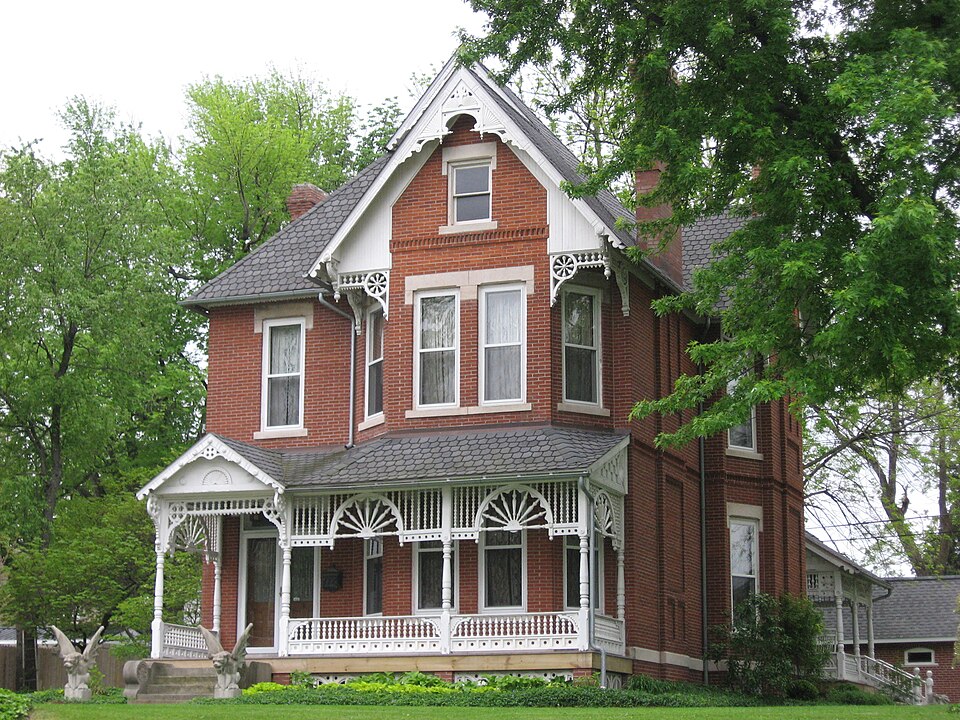
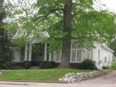
Photograph of Dr. Nelson Wilson House
Photograph by Nyttend, Public domain. Via Wikimedia Commons.

Dr Nelson Wilson House

Built in 1896 (Queen Anne style architecture in the United States). Listed on the National Register of Historic Places in 2008.

From the record

“Nelson Wilson House is a place on the National Register of Historic Places in Washington, Indiana. It was placed on the Register on June 26, 2008, due to its unique architecture, and for being the work of prominent local architect John W.”

Wikipedia article Dr. Nelson Wilson House, CC BY-SA 4.0.

One of 11 National Register listings published here for Daviess County · listed in 2008 · category: Building · built in 1896, Queen Anne style architecture in the United States, by John W. Gaddis.

Sources: the Wikipedia article · the case file at the National Archives · the National Register database, National Park Service

The listing

  • What is counted as historic. The nomination lists 1 building as contributing to the listing.
  • Listed as. Wilson, Dr Nelson, House - the National Register files a house under its owner's surname.
  • Address. 103 E National Highway, Washington, 47501
  • When was it listed? June 2008
  • Category. building
  • Township. Washington township
  • When was it built? 1896
  • Architectural style. Queen Anne style architecture in the United States
  • Architect. John W. Gaddis
  • National Register reference number. 08000566 - the number the National Park Service assigned this property when it was listed, and the key its nomination file is catalogued under at the National Archives.

The ground it stands on

136,139 words

The chapter on Washington Township in History of Knox and Daviess County, Indiana : from the Earliest Time to the Present; with Biographical Sketches, Reminiscences, Notes, Etc. ; Together with an Extended History of the Colonial Days of Vincennes, and Its Progress Down to the Formation of the State Government, published 1886 names Washington. This is what it says, exactly as the scans read.

Thomas Baird moved from Pennsylvania to Kentucky, and from Kentucky he moved to Indiana in 1801, and settled near Vincennes; in 1806 he moved on his farm near Bruceville, where he remained till his death. Joseph Baird, who is still living near Bruceville, is a son of the above. He was born in the county in 1803, and now has a silver medal given by the old settlers' reunion as the oldest native born of the county. From 1863 to 1872 he was engaged in merchandising in Bruceville. The remainder of his time has been spent on the farm. Bazil Parker came from Kentucky in 1818, and settled in the "Barrens;" later he lived near Bruceville. James Threlkeld (Tuccahoe) lived near Baird, where he remained till his death. Samuel Johnson came from Kentucky in 1826, and John Young from the Carolinas; they both lived on donations. Thomas Emison came from Kentucky about 1802 or 1803, and settled on Marie Creek. On that stream he built the first grist-mill and saw-mill in the community, at a much later date steam was added. Marks of the old mill are still visible, yet three-quarters of a century have rolled by since its first erection. James Kyle settled farther south in the township. It is probable he was from Ohio. He came while Indiana was yet a Territory. Samuel Thompson was from Kentucky. He bought the donation on which he lived from Gen. Harrison in 1804; for the 400 acres he was to pay ยง1, 000. The land was to be paid for in brick ; the deed was made and the land transferred to Thompson before a single brick was made, such was Harrison's confidence in Thompson. The bricks were made by Thompson on the farm where Mr. A. B. McKee now lives, and were used in build- ing the Harrison residence in Vincennes. John McKee came from Kentucky and settled near Emison's mill about 1807 or 1808. He was a farmer, a potter and associate judge for a time. John, Peter and David Hollingsworth were from South Carolina; they settled near McKee on Congress land. They had small stillhouses. Samuel Hollingsworth owned negroes, and on Indiana becoming a State he left his land and went South with his slaves. Nicholas Harper and "Washington Sartor lived near the Hollingsworths; the former was from Kentucky, the latter from South Carolina. He was also owner of a small still. Each came about 1810. Richard Posey settled a very short distance from Bruceville about 1805. He was a Methodist preacher and school teacher. He was the grandfather of Hon. F. B. Posey, of Petersburg. John Bolthus lived near lower part of the township. He came from Kentucky about 1807 or 1808. Daniel McClure came with the Thompsons from Kentucky not far from 1800. He was for a time justice of the peace and associate judge. A fort was built on his farm in 1812. Charles McClure was a member of the "Light Horse Company" in the war of 1812. Robert Elliott, from South Carolina, settled in Knox about 1802. He was a Baptist preacher and owner of a still-house - not an uncommon thing in those days.

Passage source: History of Knox and Daviess County, Indiana : from the Earliest Time to the Present; with Biographical Sketches, Reminiscences, Notes, Etc. ; Together with an Extended History of the Colonial Days of Vincennes, and Its Progress Down to the Formation of the State Government, published 1886.

A man named Chancellor bought a part of the land owned by Posey about 1806. He remained there till his death. Samuel Dunn settled near Bruceville about 1817, James McCord settled on the donation, where William Piety now lives. David McCord was another early settler. James Denny was from Kentucky. He lived near Posey; was a wagon-maker by trade. William D. Piety settled in Knox in 1815. He moved from Kentucky in a wagon. Shortly after settling in the township he had the misfortune to have his horses stolen. These he failed to recover. He was compelled to struggle against poverty and the un conquered forest. He was a man of sterling character. Maj. William Bruce came to Washington Township about 1804. He erected the house in which James Bruce now lives in 1811. He was the father of twenty-five children, all of whom lived beyond infancy except one.

Passage source: History of Knox and Daviess County, Indiana : from the Earliest Time to the Present; with Biographical Sketches, Reminiscences, Notes, Etc. ; Together with an Extended History of the Colonial Days of Vincennes, and Its Progress Down to the Formation of the State Government, published 1886.

Machine-read from a century-old scan, so expect the errors a machine makes: misspelled names, dropped words, stray characters.

Read the whole chapter on Washington Township - 136,139 words on its settlement, mills, schools and churches.

Fires near this property

8 since 2003

Regional context, not property-specific evidence. The federal wildfire occurrence database lists 8 fires within 5 miles of Dr Nelson Wilson House between 2003 and 2007, burning about 22 acres in total. None started naturally. 1 was recorded as arson. Distance is straight-line from the map coordinates, so a fire counted here may appear on a neighbouring settlement's page as well.

Reported cause Fires
Debris and open burning3
Missing data/not specified/undetermined2
Equipment and vehicle use1
Recreation and ceremony1
Arson/incendiarism1

The most recent of them, most recent first, with the day each was reported and the service that recorded it.

DateCause SizeReported by Name on the report
23 September 2007Missing data/not specified/undetermined10 acresIndiana State Fire Marshal's Officenot named
13 April 2006Equipment and vehicle use3.0 acresIndiana State Fire Marshal's Officenot named
9 March 2005Debris and open burning1.0 acresIndiana State Fire Marshal's Officenot named
4 March 2006Arson/incendiarism1.0 acresIndiana State Fire Marshal's Officenot named
19 March 2005Debris and open burning3.0 acresIndiana State Fire Marshal's Officenot named
28 February 2006Missing data/not specified/undetermined2.0 acresIndiana State Fire Marshal's Officenot named
21 November 2007Recreation and ceremony2.0 acresIndiana State Fire Marshal's Officenot named
25 October 2003Debris and open burningunder an acreIndiana State Fire Marshal's Officenot named

Every fire recorded in Daviess County

Mines and quarries near this property

1 within 5 miles

Regional context, not property-specific evidence. The federal mineral resources record lists 1 working within 5 miles of Dr Nelson Wilson House: 1 producer. All of them still produce. What was taken out: Stone. Distance is straight-line from the map coordinates, so a quarry counted here may appear on a neighbouring settlement's page as well.

Where SiteCommodity StatusRecorded
Daviess County Highway Dept.StoneProducer

Every working recorded in Daviess County

Storms near this property

60 of 74 shown

Regional context, not property-specific evidence. The National Weather Service names Washington, the town this property stands in, in 74 storm reports between 1995 and 2026: 37 thunderstorm wind, 17 hail, 9 flood, 8 flash flood. The reports record 32 injuries. Each account below is quoted exactly as the forecast office filed it, from the NOAA Storm Events Database, and each date opens the federal record of that event.

WhenEvent Place namedHarm What the report says
November 2005Tornado (F3)Washington31 hurt, $11,600,000An F3 tornado touched down near Washington, Indiana on the afternoon of 15 November 2005, and proceeded northeast for 12 miles, lifting at Crane Naval Base in Martin County. The tornado was up to 1/4 mile wide at times. The worst damage occurred 4 miles northeast of Montgomery. K&K Industries sits at that site. Abe Knepp, the owner, is also a chaplain for Daviess County Emergency Management, and was monitoring law enforcement radio traffic while at work. His decision to send his 120 employees home early likely saved several lives, as the plant was destroyed by the tornado 30 minutes after it was cleared. 123 homes and 20 businesses sustained damage in Daviess County. Despite the amount of damage, only one of the 31 reported injuries was considered serious.
April 1998Thunderstorm WindWashington1 hurt, $5,000Thunderstorms brought down trees and power lines in Glendale Wildlife Area. Tree fell on camper causing slight injury.
April 2006Flash FloodWashington$100,000Portions of Washington were flooded with several feet of water. At least 30 people required evacuation from their homes by fire department personnel with boats.
June 1996Thunderstorm WindWashington$100,000no account filed
May 2002Flash FloodWashington$50,000Water covered SR 257
May 2024Thunderstorm WindWashington$40,000Straight line wind damage to trees was observed through eastern Daviess County. There was a localized area of more intense damage southwest of Washington.
March 2017Tornado (EF2)South Washington$40,000The parent storm was moving southeast at 60 mph through southwest Daviess County, with a brief spin-up occurring along the line. This EF-2 tornado, with winds of approximately 113 mph, did damage that included walls blown out of a garage that was attached to a home, along with the destruction of a pole barn.
July 2025Flash FloodWashington$25,000Photos and videos showed street and parking lot flooding that encroached on homes. This includes State Rd 57 from E National Highway to Blockade St and SE 3rd St in downtown Washington.
September 2002Tornado (F2)Washington$25,000no account filed
May 2013Thunderstorm WindWashington$20,000Roof damage was reported in downtown Washington due to damaging thunderstorm wind gusts. One of the roofs was only 2 years old and debris from it flew three blocks. Some damage to old trees and structurally unsound out-buildings and canopys were also noted. Thunderstorm wind damage was observed from Southwest 5th Street to Northeast 21st Street.
May 2011Thunderstorm WindWashington$20,000A 65 to 70 mph thunderstorm wind gust was reported in this location with a wall cloud. Shingles were also reported to be blown off homes.
July 1995Thunderstorm WindWashington$15,000A 60 mph wind gust was reported at Washington where several trees and power lines were blown down.
January 2008Thunderstorm WindWashington$12,000Damaging thunderstorm winds caused a semi truck to overturn on State Route 57.
June 2019Flash FloodWashington$10,000Dispatch reported significant water issues in Washington with numerous roads underwater due to thunderstorm heavy rainfall.
May 2019Thunderstorm WindWashington$10,000A trained spotter reported several power poles down and a few trees uprooted in Washington due to strong thunderstorm wind gusts and a saturated ground. A 40 mph wind gust was noted nearby in Washington.
January 2007FloodWashington$10,000The White River in Daviess County flooded through much of January. Crests were as high as 8.6 feet above flood stage.
December 2006FloodWashington$10,000The White River flooded in Daviess County. The river crested at nearly four feet above flood stage. High water remained in southwest Indiana into January.
December 2006FloodWashington$10,000The White River flooded in Daviess County. The river crested at nearly 6 feet above flood stage.
March 2017Thunderstorm WindSouth Washington$7,000A school's portable building was blown off it's foundation due to damaging thunderstorm wind gusts. A nearby trailer was also damaged.
June 2022Thunderstorm WindWashington$5,000Thunderstorm winds snapped or uprooted multiple trees in residential section.
March 2017Thunderstorm WindWashington$5,000A storage shed was blown over due to damaging thunderstorm wind gusts. Trees were also reported down and the power was out in the area.
June 2008Flash FloodWashington$5,000All four lanes of United States Highway 50 were under water due to heavy rainfall.
June 2010Thunderstorm WindWashington$4,000Trees were reported down in this location due to damaging thunderstorm wind gusts.
May 2013Thunderstorm WindWashington$3,000Tree damage was reported in this location due to damaging thunderstorm wind gusts.
July 2009Thunderstorm WindWashington$3,000Trees were blown down by thunderstorm wind gusts.
August 2024Thunderstorm WindSouth Washington$1,000Thunderstorm winds downed a tree at the intersection of County Roads 125 East and 400 South.
September 2018Flash FloodWashington$1,000Water was flowing over Highway 50 near Interstate 69 due to heavy rainfall.
June 2007FloodWashington$1,000Law enforcement reported water across county road 100 W just west of Washington.
May 1998Thunderstorm WindWashington$1,000A few trees and numerous limbs were blown down.
January 2012Thunderstorm WindWashington$750A telephone pole was reported down at Southwest 3rd and Washington Streets due to damaging thunderstorm wind gusts. Pea sized hail was also reported.
April 2015FloodWashington$500Some minor road flooding was occurring due to heavy thunderstorm rainfall.
June 2015FloodWashington$500Some minor street flooding occurred in this location due to heavy rainfall.
August 2013FloodWashington$500Flooding was occurred over Highway 50, east of Washington, due to thunderstorm heavy rainfall.
September 2013FloodWashington$500Flooding was occurred over Highway 50, east of Washington, due to thunderstorm heavy rainfall.
May 2011Thunderstorm WindWashington$500A 10 inch tree was downed in this location due to damaging thunderstorm wind gusts.
June 2023HailSouth Washington-Thunderstorm hail lasted about five minutes.
May 2022HailWashington-Thunderstorm produced estimated 1.25 inch hail that was found along road after partially melting.
June 2019Thunderstorm WindWashington-An estimated 65 mph thunderstorm wind gust was reported in this approximate location.
May 2016Thunderstorm WindWashington-An estimated 60 mph thunderstorm wind gust was observed in this location.
April 2012Thunderstorm WindWashington-An estimated 90 mph thunderstorm wind gust was observed in Washington, Indiana.
July 2012Thunderstorm WindWashington-An estimated thunderstorm wind gust of 70 mph was observed in this location.
October 2010Thunderstorm WindWashington-A thunderstorm wind gust estimated at 60 to 70 MPH was observed at State Route 57 and Viola Avenue. Some rotation was possibly noted as well.
February 2006Thunderstorm WindWashington-Trees downed.
March 2005Thunderstorm WindWashington-A large tree and several limbs were taken down.
March 2005Thunderstorm WindWashington-Trees and power lines were blown down on Old Highway U.S. 50 West.
April 2005Thunderstorm WindWashington-Trees and power lines were blown down.
November 2005Thunderstorm WindWashington-Trees were downed.
May 1998FloodWashington-Heavy rains flooded many parts of the county.
April 2026HailWashington-no account filed
May 2016HailWashington-no account filed
April 2013HailSouth Washington-no account filed
April 2012HailWashington-no account filed
July 2012HailWashington-no account filed
May 2006HailWashington-no account filed
July 2004HailWashington-no account filed
June 2004HailWashington-no account filed
May 2003HailWashington-no account filed
May 2003Thunderstorm WindWashington-no account filed

Every storm recorded in Daviess County

Map coverage status

No historic map-sheet match is published for this property yet. That does not mean no map exists. This record needs a coordinate-quality review before it can be joined to a sheet boundary. Browse the county's mapped places while that work is pending.

Listed places nearby

6 within 8 miles

Other National Register properties close enough to walk or drive between, ordered by distance from this one. Both positions come from the same geocoding pass that matched these properties to their map sheets.

Photograph PropertyDistance Listed
Washington Commercial Historic District0.4 miles1990
Magnus J. Carnahan House0.4 miles1991
Daviess County Courthouse0.5 miles2008
Dr. John A. Scudder House0.5 miles1995
Robert C. Graham House0.7 miles1983
Beulah A. M. E. Church & Dunbar School0.8 miles2026

Sources for this property

National Archives recordThe nomination case file for reference 08000566 in Record Group 79.
Wikipedia articleCommunity-written account of this property, licensed CC BY-SA.
Daviess CountyAll 11 listed properties in this county.

Provenance

  • Listing record. National Park Service National Register of Historic Places, listed-properties dataset, current to 2026-05-22.
  • Map join. Address geocoded through the United States Census geocoder, then tested against the published boundary of every sheet in the USGS Historical Topographic Map Collection.
  • How this page is made. Listing fields come from federal records; map-sheet coverage is a labelled coordinate-to-boundary calculation, not a source-field claim.
  • Wildfire. Short, Karen C. 2022. Spatial wildfire occurrence data for the United States, 1992-2020 [FPA_FOD_20221014]. 6th Edition. Fort Collins, CO: Forest Service Research Data Archive. https://doi.org/10.2737/RDS-2013-0009.6 Collected with United States Government funding and usable without additional permissions or fees.
  • Mines and quarries. USGS Mineral Resources Data System (MRDS) https://mrdata.usgs.gov/mrds/ A work of the United States government, no copyright under 17 U.S.C. 105.
  • Storms. NOAA National Centers for Environmental Information, Storm Events Database https://www.ncei.noaa.gov/stormevents/ A work of the United States government, no copyright under 17 U.S.C. 105. Narratives are quoted verbatim from the National Weather Service report and are not edited or summarised.