BlockBefore
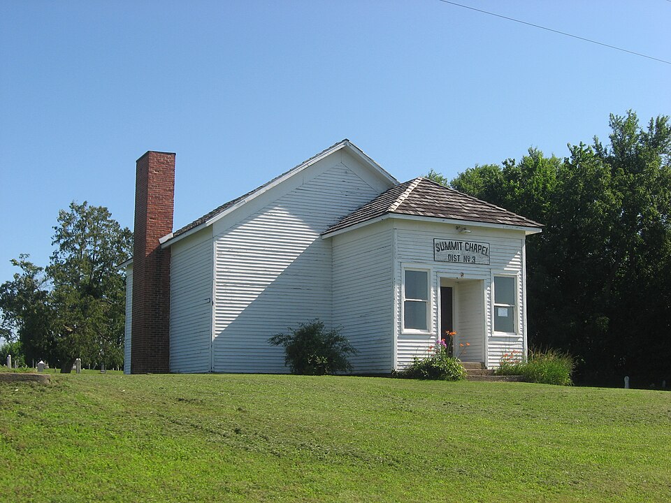
Photograph of Tippecanoe Twp. District No. 3 Schoolhouse and Cemetery
Photograph by Nyttend, Public domain. Via Wikimedia Commons.

Tippecanoe Twp. District No. 3 Schoolhouse and Cemetery

Listed on the National Register of Historic Places in 2008.

From the record

“District No. 3 Schoolhouse and Cemetery is a place on the National Register of Historic Places in Tippecanoe, Indiana. It was placed on the Register on June 24, 2008.”

Wikipedia article Tippecanoe Twp. District No. 3 Schoolhouse and Cemetery, CC BY-SA 4.0.

One of 34 National Register listings published here for Marshall County · listed in 2008 · category: Building.

Sources: the Wikipedia article · the case file at the National Archives · the National Register database, National Park Service


The listing

  • What is counted as historic. The nomination lists 2 buildingss, 1 site as contributing to the listing.
  • Address. State Rd 10 at Birch Rd, Tippecanoe, 46504
  • When was it listed? June 2008
  • Category. building
  • Also known as. Indiana's Public Common and High Schools MPS
  • Township. Tippecanoe township
  • National Register reference number. 08000567 - the number the National Park Service assigned this property when it was listed, and the key its nomination file is catalogued under at the National Archives.

What happened here

An account from the chapter on Tippecanoe township. The inset identifies its exact source book and publication year.

From McDonald, Daniel - History Of Marshall County, Indiana 1836-1880 (Kingman Bros., 1881), published 1881 - Tippecanoe Township

Deaths By Accident And Otherwise

This locality has been remarkably free from murders, suicides and aecidental deaths, so far as can be ascertained. James Welch, above noted, seems to have been the first one in this region who "shuffled off this mortal coil" of his own volition. No cause is known for his untimely taking off.

Read the rest of this passage

The ground it stands on

4,079 words

The chapter on Tippecanoe Township in McDonald, Daniel - History Of Marshall County, Indiana 1836-1880 (Kingman Bros., 1881), published 1881 names Tippecanoe. This is what it says, exactly as the scans read.

The first settlers of Tippecanoe Township were A. H. Buckman and family, and a man by the name of James Welch, and wife, who settled there in 1835. Welch was of the opinion that the future had no good in store for him, and committed suicide by cutting his throat with a razor, and was buried in what is now the farm of Zachariah Senior, and was the first white person buried in the township. James Turner settled on the farm he now oceupies, the following summer, and is now the oldest settler in the township. The first school was taught in the summer of 1842, at what is now Schoolhouse No. 3, by Esther Birney, who taught there three successive terms. Among prominent early settlers were Thomas H. McKey, Samuel R. Koons, William Sprout. Thomas Ivens, Samuel Rockhill and Levi Holloway, none of whom remain except the latter. 'The Pottawatomie Chief, Benack, and many of his tribe, lived at this time on the banks of the Tippecanoe River, a short distance above Tippecanoe Town,

Passage source: McDonald, Daniel - History Of Marshall County, Indiana 1836-1880 (Kingman Bros., 1881), published 1881.

Tippecanoe River, which meanders throngh this township, entering it on the eastern boundary, about the middle, running toward the center aud veering off to the south, furnishes an excellent water-power at Tippecanoe Town for milling purposes. The dam across the river at this point was originally built, it is said, by the original proprietors of the town. The flouring mill now in operation was built by N. B. & P. S. Alleman, of Plymouth, who operated it until within a few years past. During the war, the Messrs, Alleman erected a woolen factory close by, which they operated in connection with others until IS7S, when they disposed of it to J. F. Van Valkenburg, of Plymouth. On the night of October 25, IN7S, the woolen mills were fired by an incendiary, and, before assistance could reach them, were entirely destroyed. An attempt was made to set fire to the grist-mill the same night, but « watchman being in the mill, the attempt was unsuccessful. Detectives were put on track of the " fire-fiond," and in course of time a young man in the neighborhood was arrested on suspicion of having committed the deed. He was inearcerated in the County Jail, and soon after gave intimation

Passage source: McDonald, Daniel - History Of Marshall County, Indiana 1836-1880 (Kingman Bros., 1881), published 1881.

Machine-read from a century-old scan, so expect the errors a machine makes: misspelled names, dropped words, stray characters.

Read the whole chapter on Tippecanoe Township - 4,079 words on its settlement, mills, schools and churches.

Mines and quarries near this property

2 within 5 miles

Regional context, not property-specific evidence. The federal mineral resources record lists 2 workings within 5 miles of Tippecanoe Twp. District No. 3 Schoolhouse and Cemetery: 1 producer, 1 past producer. 1 still produces. What was taken out: Sand and Gravel, Construction. Distance is straight-line from the map coordinates, so a quarry counted here may appear on a neighbouring settlement's page as well.

Where SiteCommodity StatusRecorded
J & M Gravel PitSand and Gravel, ConstructionProducer
PitSand and Gravel, ConstructionPast Producer

Every working recorded in Marshall County

Storms near this property

15 since 1997

Regional context, not property-specific evidence. The National Weather Service names Tippecanoe, the town this property stands in, in 15 storm reports between 1997 and 2025: 8 thunderstorm wind, 3 hail, 2 tornado, 2 flood. The reports record 1 injury. Each account below is quoted exactly as the forecast office filed it, from the NOAA Storm Events Database, and each date opens the federal record of that event.

WhenEvent Place namedHarm What the report says
May 1997Thunderstorm WindTippecanoe1 hurtA trailer was blown over, one person was injured.
January 2008FloodTippecanoe$150,000Several county and some city roads experienced high water on them for a few days as low areas, ditches and creeks exceeded capacity from one to three inches of rain. Some residences were affected in and around Plymouth as a result of flood waters from the rising Yellow River. The town of Tippecanoe also had some flooding issues with the Tippecanoe River going over its banks. Schools were closed on parts of the area during the even. No exact damage were available, but is estimated at $150,000 for road repairs and structure damage.
July 2024Tornado (EF0)Tippecanoe$20,000A survey of damage confirmed a brief tornado, embedded with a larger area of damaging winds. The tornado touched down southwest of the intersection of 19th Rd and Birch Rd, then moved northeast. Damage was confined to several trees being snapped or uprooted in the area.
June 2025Thunderstorm WindTippecanoe$10,000Downed powerlines between Tippecanoe and Mentone.
October 2001Tornado (F0)Tippecanoe$5,000no account filed
August 2021Thunderstorm WindTippecanoe-A CoCoRaHS observer reports several 6 inch diameter limbs were downed and that corn was flattened.
June 2015Thunderstorm WindTippecanoe-Trees down.
June 2015FloodTippecanoe-Numerous reports of high water and general flooding throughout Plymouth, with several inches of standing water. Other reports of high water were received throughout the county, especially in the Tippecanoe area.
June 2014Thunderstorm WindTippecanoe-Emergency management officials reported trees down.
January 2013HailTippecanoe-A trained spotter reported hail up to the size of nickels covering the ground. Visibility was reduced to one eighth of a mile during the hail fall.
June 2012Thunderstorm WindTippecanoe-A trained spotter observed multiple small tree limbs down with estimated wind gusts to 60 mph.
July 2003Thunderstorm WindTippecanoe-Law enforcement reported large trees down in Tippecanoe.
June 2025Thunderstorm WindTippecanoe-no account filed
June 2011HailTippecanoe-no account filed
July 2003HailTippecanoe-no account filed

Every storm recorded in Marshall County

Map coverage status

No historic map-sheet match is published for this property yet. That does not mean no map exists. This record needs a coordinate-quality review before it can be joined to a sheet boundary. Browse the county's mapped places while that work is pending.

Listed places nearby

6 within 8 miles

Other National Register properties close enough to walk or drive between, ordered by distance from this one. Both positions come from the same geocoding pass that matched these properties to their map sheets.

Sources for this property

National Archives recordThe nomination case file for reference 08000567 in Record Group 79.
Wikipedia articleCommunity-written account of this property, licensed CC BY-SA.
Marshall CountyAll 34 listed properties in this county.

Provenance

  • Listing record. National Park Service National Register of Historic Places, listed-properties dataset, current to 2026-05-22.
  • Map join. Address geocoded through the United States Census geocoder, then tested against the published boundary of every sheet in the USGS Historical Topographic Map Collection.
  • How this page is made. Listing fields come from federal records; map-sheet coverage is a labelled coordinate-to-boundary calculation, not a source-field claim.
  • Mines and quarries. USGS Mineral Resources Data System (MRDS) https://mrdata.usgs.gov/mrds/ A work of the United States government, no copyright under 17 U.S.C. 105.
  • Storms. NOAA National Centers for Environmental Information, Storm Events Database https://www.ncei.noaa.gov/stormevents/ A work of the United States government, no copyright under 17 U.S.C. 105. Narratives are quoted verbatim from the National Weather Service report and are not edited or summarised.