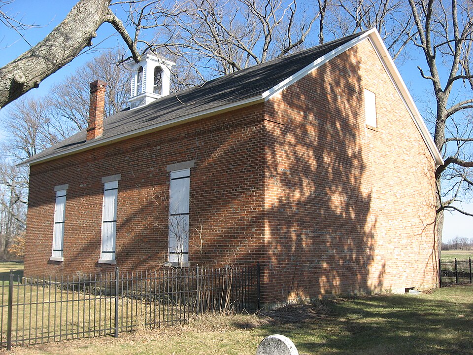
Listed on the National Register of Historic Places in 2008.
From the record
“The Mount Zion Methodist Episcopal Church is a historic Methodist church located in Union Township, Delaware County, Indiana, United States. It was built in 1867, and is a modest, one-room, brick church with a reconstructed bell tower.”
Wikipedia article Mount Zion Methodist Episcopal Church (Eaton, Indiana), CC BY-SA 4.0.
One of 47 National Register listings published here for Delaware County · listed in 2008 · category: Building.
National Register reference number.08000915- the number the National Park Service assigned this property when it was listed, and the key its nomination file is catalogued under at the National Archives.
Mr. Bartlet was married February I 5, 1887, in Eaton, to Miss Lola, daughter of David Brandt, of Eaton, and one child has been born, September 22, 1891, and has been named Lerlie. Mr. Bartlett believes that the democratic party advocates those measures which will best govern this great country, hence he always votes with that organization. Socially, he is a member of the Masonic order and is much esteemed in his place of residence. He is one of the representative business men of the town in which he resides and enjoys the confidence and esteem of a large and influential circle of friends throughout Delaware and adjacent counties.
David Brandt, Jr., was reared to manhood in Fairfield county, Ohio, and there learned the shoemaker trade, in which he was engaged until 1840. He left Ohio February 17, of that year, and located in Cass county, Ind., where he was engaged in the manufacture of shoes until May 15, 1842, when he came to Delaware county, locating in Union township, where he followed the shoe business, moving in 1851 to the town of Eaton, with the comm.ercial interests of which he has since been prominently identified. He has now a very prosperous business, owning a dry goods store, and also dealing in boots and shoes. Mr. Brandt has seen the country grow from a wilderness to its present advanced state of civilization. When he came, it was an almost unbroken forest and the location where his business house now stands was covered with brambles. He can relate, in the most interesting manner, tales of those early times when all settlers stood upon the same social plane, and good feeling and hospitality were universal. During his long residence here he has seen the changes, many for the better, but a few not so much so. At one time Mr. Brandt owned 400 acres of land, but he has sold all but eighty, in this township. He married in this county, October 22, 1842, Miss Jane
Regional context, not property-specific
evidence. The
federal wildfire occurrence database
lists 1 fire within 5 miles of Mount Zion Methodist Episcopal Church
in 2004, burning under an acre in total. None started naturally. None was recorded as arson.
Distance is straight-line from the map coordinates, so a fire counted
here may appear on a neighbouring settlement's page as well.
Reported cause
Fires
Recreation and ceremony
1
The most recent of
them, most recent first, with the day each was reported and the service
that recorded it.
Date
Cause
Size
Reported by
Name on the report
30 October 2004
Recreation and ceremony
under an acre
Indiana State Fire Marshal's Office
not named
Mines and
quarries near this property
3 within 5 miles
Regional context, not property-specific
evidence. The federal mineral resources record lists
3 workings within 5 miles of Mount Zion Methodist Episcopal Church: 2 past producers, 1 producer.
1 still produces. What was taken out: Stone, Crushed/Broken, Sand and Gravel, Construction. Distance is straight-line from the
map coordinates, so a quarry counted here may appear on a neighbouring
settlement's page as well.
Regional context, not property-specific
evidence. The National Weather Service names
Eaton, the town this property stands in, in 22 storm reports between 1998 and 2025: 11 thunderstorm wind, 8 hail, 1 flood, 1 funnel cloud.
No death or injury is recorded in these reports. Each account below is quoted exactly as the forecast office
filed it, from the NOAA Storm Events Database, and each date
opens the federal record of that event.
A long track, EF2 tornado, with winds estimated at 134 mph, started northeast of Eaton in Delaware County then traveled into Blackford County and then into Ohio. Mainly tree damage in Delaware County until the Delaware-Blackford County border, where a Quonset hut was collapsed. Several tractors and a vintage Harley Davidson were inside and heavily damaged. Winds in this location before pushing into Blackford County were estimated at 120 mph. More significant damage was done farther north along the path.
Law enforcement reported an overturned trailer on Interstate 69 at the 51mile marker. Also numerous trees and power lines down including one on a house that caused roof and porch damage.
A 10-inch diameter tree was blown down and a 6-inch diameter tree limb was torn down due to a damaging thunderstorm wind gust on Eaton-Wheeling Pike between Walnut Street and State Road 3.
No historic map-sheet match is published
for this property yet. That does not mean no map exists. This record needs
a coordinate-quality review before it can be joined to a sheet boundary.
Browse the county's mapped places while that work is
pending.
Listed places nearby
2 within 8 miles
Other National Register properties close
enough to walk or drive between, ordered by distance from this one. Both
positions come from the same geocoding pass that matched these properties
to their map sheets.
Listing record. National Park Service National Register of Historic Places, listed-properties dataset, current to 2026-05-22.
Map join. Address geocoded through the United States Census geocoder, then tested against the published boundary of every sheet in the USGS Historical Topographic Map Collection.
How this page is made. Listing fields come from federal records; map-sheet coverage is a labelled coordinate-to-boundary calculation, not a source-field claim.
Wildfire. Short, Karen C. 2022. Spatial wildfire occurrence data for the United States, 1992-2020 [FPA_FOD_20221014]. 6th Edition. Fort Collins, CO: Forest Service Research Data Archive. https://doi.org/10.2737/RDS-2013-0009.6 Collected with United States Government funding and usable without additional permissions or fees.
Mines and quarries. USGS Mineral Resources Data System (MRDS) https://mrdata.usgs.gov/mrds/ A work of the United States government, no copyright under 17 U.S.C. 105.
Storms. NOAA National Centers for Environmental Information, Storm Events Database https://www.ncei.noaa.gov/stormevents/ A work of the United States government, no copyright under 17 U.S.C. 105. Narratives are quoted verbatim from the National Weather Service report and are not edited or summarised.
 Block