 Block
From the record
One of 22 National Register listings published here for Johnson County · listed in 2017 · category: District.
Sources: the National Register database, National Park Service
Listed on the National Register of Historic Places in 2017.
One of 22 National Register listings published here for Johnson County · listed in 2017 · category: District.
Sources: the National Register database, National Park Service
The chapter on Pleasant Township in History of Johnson County, Indiana : from the Earliest Time to the Present, with Biographical Sketches, Notes, Etc. Together with a Short History of the Northwest, the Indiana Territory, and the State of Indiana, published 1888 names Greenwood. This is what it says, exactly as the scans read.
Harvey Brewer, a prominent druggist of Greenwood, was born on a farm upon which is built the town of Greenwood, April 19, 1844. He was the son of Abram V. and Delilah (Rice) Brewer, both of whom were natives of Mercer County, Ky., of German descent. They were reared and married in their native county, and came to Johnson County, and located on a tract of land where Greenwood now stands, in an early day. His boyhood was spent on the old homestead, and at fifteen years of age he entered Depauw University, where he attended two years. He then returned home and remained until he attained the age of twenty-two. At this age he started out into the world to do for himself. Making his way to Topeka, Kan., he there clerked in a drug store two years. He then returned to this county, and on the 7th day of October, 1869, he was married to Alice Polk, daughter of George W. and Mary (Embree) Polk, whose history is given elsewhere. In 1872, he became the proprietor of a drug store in that place, to which his attention has since been directed. He has enjoyed a good trade and one that has enabled him to accumulate considerable property. He has also dealt in money more or less. Besides his brick business block and elegant residence in Greenwood, he owns three farms which comprise a total acreage of 235 acres. The wife of Mr. Brewer, died May 1, 1886, leaving four children: Fred C, Maude F., Mamie A. and Alma M., all of whom are living. Mr. Brewer is a member of the Presbyterian Church, and of the Masonic fraternity, having reached the thirty-second degree. In politics, he is an ardent republican. He possesses good business qualifications, and is one of the substantial men of the county.
Passage source: History of Johnson County, Indiana : from the Earliest Time to the Present, with Biographical Sketches, Notes, Etc. Together with a Short History of the Northwest, the Indiana Territory, and the State of Indiana, published 1888.
William A. Brooks, an honored old citizen of Pleasant Township, was born in Clinton County, N. Y., November 28, 1822, and was the son of. Gehial and Rebecca (Anson) Brooks, who were also natives of the State of New York. His boyhood was spent on a farm in his native county. At seventeen years of age he accompanied his widowed mother to Madison, this state, where they remained some five or six years, and during that time he was chiefly employed at the carpenter's trade. In 1850, the family settled on a farm in Jennings County, this state. On the 10th day of June, of the same year, he was married to Eliza J. Griffith. She was born in Jennings County, Ind., and was the daughter of Thomas and Hannah Griffith. In 1855, Mr. Brooks removed with his family from Jennings County to Johnson County, and he has ever since been a resident of Pleasant Township. His occupation has been that of a farmer, and in this pursuit he has been successful. He owns a first-class farm of 100 acres, two and one-half miles southeast of Greenwood, which is in a good state of improvement, and nearly all of which is in cultivation. Upon this place he settled when he first came to the county, and he continued to occupy it until 1878. His first wife died October 4, 1864, and on the 20th day of June, 1877, Mr. Brooks was married to Mrs. Ann Brewer. She was born in Mercer County, Ky., March 29, 1825, and was the daughter of Henry R. and Elizabeth (Smock) Comingore, both of whom were natives of Mercer County, Ky. Her father was the son of Henry and Rachel (Brewer) Comingore, the former a native of Holland, and the latter a native of Pennsylvania. Her mother was the daughter of Jacob and Ann (Banta) Smock, who were, respectively, natives of Pennsylvania and Mercer County, Ky. The father and mother of Jacob Smock were natives of Holland. On the 18th day of February, 1847, Mrs. Brooks was married to John C. Brewer, who was a native of Mercer County, Ky., born January 8, 182 1, and was the son of Abram and Ann (Cozine) Brewer. John C. Brewer died January 24, 1874, after which his wife remained a widow until her marriage to Mr. Brooks. The first marriage of Mr. Brooks resulted in the birth of six children: Henry W., Jane E., Charlotte S., Albert R., Hannah R., and Mary E., of whom Charlotte S. and Mary E., are deceased. The first marriage of Mrs. Brooks resulted in the birth of eight children: Mary A., born March 26, 1848; Sarah Elizabeth, August 29, 1849; Laura J., February 3, 1852, deceased; Macella A., January 17, 1854; Eldora, January 11, 1856; Laura M., December 29, 1857; Charles E., May 18, 1861; John Edward, July 3, 1864. The wife of Mr. Brooks is a member of the Presbyterian Church; he is a member of the Baptist Church, and in politics, he is an ardent republican. Mr. Brooks is a director and heavy stockholder in the Whiteland Fruit Packing Company, a history of which appears elsewhere. He is an influential And reliable man, and he and wife are highly respected.
Passage source: History of Johnson County, Indiana : from the Earliest Time to the Present, with Biographical Sketches, Notes, Etc. Together with a Short History of the Northwest, the Indiana Territory, and the State of Indiana, published 1888.
Machine-read from a century-old scan, so expect the errors a machine makes: misspelled names, dropped words, stray characters.
Read the whole chapter on Pleasant Township - 22,145 words on its settlement, mills, schools and churches.
Regional context, not property-specific evidence. The federal mineral resources record lists 1 working within 5 miles of Greenwood Residential Historic District: 1 unknown. None of them still produces. What was taken out: Sand and Gravel, Construction. Distance is straight-line from the map coordinates, so a quarry counted here may appear on a neighbouring settlement's page as well.
| Where | Site | Commodity | Status | Recorded |
|---|---|---|---|---|
| Kelsay & York Gravel Pit | Sand and Gravel, Construction | Unknown |
Regional context, not property-specific evidence. The National Weather Service names Greenwood, the town this property stands in, in 80 storm reports between 1994 and 2025: 39 hail, 31 thunderstorm wind, 7 lightning, 2 tornado. The reports record 3 deaths and 2 injuries. Each account below is quoted exactly as the forecast office filed it, from the NOAA Storm Events Database, and each date opens the federal record of that event.
| When | Event | Place named | Harm | What the report says |
|---|---|---|---|---|
| June 2008 | Thunderstorm Wind | Greenwood | 3 killed, 2 hurt, $10,000 | Thunderstorm winds contributed to the collapse of a wall and scaffolding at a construction site in the Precedent South Business Center south of Main Street near I-65. The incident killed 3 and injured 2. All were male workers. |
| September 2002 | Tornado (F3) | Greenwood | $25,000,000 | no account filed |
| March 2006 | Tornado (F2) | Greenwood | $3,000,000 | A tornado touched down just west of Interstate 65 and Main Street in Greenwood on the evening of 31 March 2006. This tornado was on the ground for 25 minutes, covered an area 17 miles long, and caused significant damage to several homes and businesses along its path, which continued into neighboring Shelby County. At its peak, near the small town of London in Shelby County, the tornado was a strong F2, with a width of four tenths of a mile. The tornado lifted near US 52 and State Road 9 in north central Shelby County. According to the American Red Cross of Greater Indianapolis, more than 140 homes were damaged, some of them severely. Fortunately, no fatalities or life-threatening injuries were reported, although at least one driver, Megan Mahoney of Chesterfield, MO, sustained a concussion when her car was rolled or tossed off of Interstate 74 in Shelby County and into the yard of a home over 150 feet away. This was the third significant tornado in just over three and a half years to affect the southern suburbs of the Indianapolis metropolitan area. |
| June 2005 | Lightning | Greenwood | $200,000 | Lightning sparked a fire that heavily damaged the third floor of the Polo Run Apartments in Greenwood. |
| August 2000 | Thunderstorm Wind | Greenwood | $200,000 | no account filed |
| June 1999 | Thunderstorm Wind | Greenwood | $200,000 | no account filed |
| April 2006 | Lightning | Greenwood | $100,000 | A lightning strike set fire to a home in Greenwood. The fire spread quickly up a chimney space and destroyed an upstairs bedroom and the roof, and collapsed some of the second floor. |
| August 2000 | Lightning | Greenwood | $100,000 | no account filed |
| January 1999 | Lightning | Greenwood | $75,000 | Lightning struck a church a caused a fire which inflicted heavy damage on it. |
| August 2000 | Lightning | Greenwood | $60,000 | no account filed |
| May 2003 | Lightning | Greenwood | $15,000 | no account filed |
| May 2002 | Thunderstorm Wind | Greenwood | $10,000 | Part of a roof blown off a house that was under contstruction |
| May 1996 | Lightning | Greenwood | $10,000 | no account filed |
| June 1998 | Thunderstorm Wind | Greenwood | $8,000 | no account filed |
| July 2009 | Thunderstorm Wind | Greenwood | $7,000 | Thunderstorm wind gusts downed trees near Greenwood. |
| July 2014 | Thunderstorm Wind | Greenwood | $5,000 | Plate glass windows were blown out on the southeast corner of Value City Furniture due to damaging thunderstorm wind gusts. Additionally, the awning on the Vitamin Shoppe, in front of Value City Furniture, was ripped off of the building. |
| June 1994 | Thunderstorm Wind | Greenwood | $5,000 | Power lines were downed. |
| July 2013 | Thunderstorm Wind | Greenwood | $4,000 | Trees were reported down in this location due to damaging thunderstorm wind gusts. This report was received via Twitter. |
| June 2008 | Thunderstorm Wind | Greenwood | $4,000 | Thunderstorm winds uprooted a tree, blew down a tree limb approximately 9 inches in diameter, and blew down a 5-foot by 7-foot church sign. A number of small limbs were found down along Main Street in downtown Greenwood. |
| April 2025 | Thunderstorm Wind | Greenwood | $2,000 | Trees of unknown size downed by thunderstorm wind gusts. |
| July 2006 | Thunderstorm Wind | Greenwood | $2,000 | Trees, power lines, and at least one power pole were damaged. |
| April 1997 | Thunderstorm Wind | Greenwood | $2,000 | no account filed |
| July 2015 | Thunderstorm Wind | Greenwood | $1,000 | A tree was downed near the intersection of Highway 31 and Smith Valley Road due to damaging thunderstorm wind gusts. |
| July 2014 | Thunderstorm Wind | Greenwood | $1,000 | A two to three foot diameter tree was snapped at its base in front of the Greenwood Park Mall due to damaging thunderstorm wind gusts. |
| October 2010 | Thunderstorm Wind | Greenwood | $1,000 | Power lines were reported down at Stop 18 and Highway 31 due to damaging thunderstorm wind gusts. |
| January 2013 | Thunderstorm Wind | Greenwood | $750 | A power pole was leaning on Fry Road, near the intersection with US Route 31 just south of the Greenwood Park Mall, due to damaging thunderstorm wind gusts. |
| June 2010 | Thunderstorm Wind | Greenwood | $500 | Tree damage was reported one quarter mile north of West Smith Valley Road. A 6 to 8 inch split in the tree trunk was observed. |
| August 2012 | Hail | Greenwood | - | Nickel to quarter sized hail was reported one mile west of the Greenwood airport. |
| August 2012 | Hail | Greenwood | - | Quarter sized hail was reported at Greenwood Mall. |
| April 2010 | Hail | Greenwood | - | Event occurred 1 mile west of the Greenwood airport. |
| October 2010 | Hail | Greenwood | - | Dime to pea sized hail was reported at the intersection of County Line Road and Madison Avenue. |
| April 2005 | Thunderstorm Wind | Greenwood | - | Trees were blown down. |
| June 2005 | Thunderstorm Wind | Greenwood | - | The roof was blown off of a trailer and several trees and power lines were downed. |
| June 2005 | Thunderstorm Wind | Greenwood | - | Trees were blown down. |
| July 2005 | Thunderstorm Wind | Greenwood | - | Numerous trees were blown down. |
| June 2002 | Thunderstorm Wind | Greenwood | - | Trees down. |
| August 2002 | Thunderstorm Wind | Greenwood | - | Trees down |
| June 1995 | Thunderstorm Wind | Greenwood | - | Numerous large tree limbs blown down. |
| July 2023 | Hail | Greenwood | - | no account filed |
| April 2015 | Hail | Greenwood | - | no account filed |
| April 2015 | Hail | Greenwood | - | no account filed |
| April 2015 | Hail | Greenwood | - | no account filed |
| April 2015 | Hail | Greenwood | - | no account filed |
| April 2015 | Hail | Greenwood | - | no account filed |
| April 2015 | Hail | Greenwood | - | no account filed |
| June 2015 | Hail | Greenwood | - | no account filed |
| March 2012 | Hail | Greenwood | - | no account filed |
| March 2012 | Hail | Greenwood | - | no account filed |
| August 2012 | Hail | Greenwood | - | no account filed |
| August 2012 | Hail | Greenwood | - | no account filed |
| June 2011 | Hail | Greenwood | - | no account filed |
| June 2011 | Hail | Greenwood | - | no account filed |
| May 2011 | Hail | Greenwood | - | no account filed |
| May 2011 | Hail | Greenwood | - | no account filed |
| May 2011 | Hail | Greenwood | - | no account filed |
| May 2011 | Hail | Greenwood | - | no account filed |
| April 2006 | Hail | Greenwood | - | no account filed |
| April 2006 | Hail | Greenwood | - | no account filed |
| June 2006 | Hail | Greenwood | - | no account filed |
| April 2005 | Hail | Greenwood | - | no account filed |
No historic map-sheet match is published for this property yet. That does not mean no map exists. This record needs a coordinate-quality review before it can be joined to a sheet boundary. Browse the county's mapped places while that work is pending.
Other National Register properties close enough to walk or drive between, ordered by distance from this one. Both positions come from the same geocoding pass that matched these properties to their map sheets.
| Photograph | Property | Distance | Listed |
|---|---|---|---|
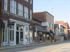 | Greenwood Commercial Historic District | 0.4 miles | 1991 |
| Bagby-Doub Farmstead | 2.3 miles | 2021 |
| National Archives record | The nomination case file for reference 100001059 in Record Group 79. |
| Johnson County | All 22 listed properties in this county. |