 Block
From the record
One of 19 National Register listings published here for Clark County · listed in 2019 · category: District.
Sources: the National Register database, National Park Service
Listed on the National Register of Historic Places in 2019.
One of 19 National Register listings published here for Clark County · listed in 2019 · category: District.
Sources: the National Register database, National Park Service
Regional context, not property-specific evidence. The federal mineral resources record lists 9 workings within 5 miles of Indiana State Prison South-Indiana Reformatory- Colgate-Palmolive Historic District: 4 past producers, 3 producers, 1 plant, 1 unknown. 4 still produce. What was taken out: Sand and Gravel, Construction, Stone, Crushed/Broken, Salt, Lead. Distance is straight-line from the map coordinates, so a quarry counted here may appear on a neighbouring settlement's page as well.
| Where | Site | Commodity | Status | Recorded |
|---|---|---|---|---|
| Cargill Salt/ Clarksville, Ind. | Salt | Plant | ||
| Globe Union/ Louisville, Ky. | Lead | Unknown | ||
| Pilot Co. Pit | Magnesite | Past Producer | ||
| Atkins Plant & Quarry | Stone, Crushed/Broken | Producer | ||
| Louisville Sand&Gravel Inc | Stone, Crushed/Broken | Past Producer | ||
| Alert Dredge | Sand and Gravel, Construction | Producer | ||
| First Street Yard | Sand and Gravel, Construction | Producer | ||
| Martha E. Green Dredge | Sand and Gravel, Construction | Past Producer | ||
| Nugent Plant | Sand and Gravel, Construction | Past Producer |
Regional context, not property-specific evidence. The National Weather Service names Clarksville, the town this property stands in, in 24 storm reports between 1996 and 2021: 8 thunderstorm wind, 8 hail, 5 flash flood, 1 tornado. No death or injury is recorded in these reports. Each account below is quoted exactly as the forecast office filed it, from the NOAA Storm Events Database, and each date opens the federal record of that event.
| When | Event | Place named | Harm | What the report says |
|---|---|---|---|---|
| May 2004 | Tornado (F1) | Clarksville | $500,000 | A very narrow F1 tornado moved through Clarksville and Jeffersonville. It touched down in Old Clarksville by the floodwall at the end of Arlington Drive. It moved east northeast through a residential area, causing mainly F0 damage to trees and some F1 roof damage to homes. It crossed Interstate 65 between exits 1 and 2, and moved into Jeffersonville. The tornado reached its maximum strength in the Martin Circle area, where it ripped a section off the roof of a community center, and tossed it into a nearby house. It next moved into an industrial park and did some roof damage to commercial buildings and businesses. The tornado crossed 10th Street and moved into another residential area, doing some more F0 damage to trees. It lifted near the end of Plaza Drive in Jeffersonville. |
| June 2021 | Thunderstorm Wind | Clarksville | - | A picture on social media showed a large limb and power pole down in Clarksville. |
| April 2015 | Hail | Clarksville | - | Broadcast media relayed that 1 inch diameter hail fell in Clarksville. |
| July 2015 | Flash Flood | Clarksville | - | A broadcast meteorologist relayed a report of side street flooding in Clarksville. The southern part of the county received 3 to locally 4 inches in 2 hours. |
| July 2015 | Thunderstorm Wind | Clarksville | - | A broadcast meteorologist relayed a report that severe thunderstorm winds resulted in a tree falling on a carport in Clarksville. |
| May 2014 | Hail | Clarksville | - | A spotter reported one inch hail covering Veterans' Parkway. |
| May 2012 | Flash Flood | Clarksville | - | Law enforcement in Jeffersonville reported cars were stalled within several flooded intersections. |
| September 2012 | Flood | Clarksville | - | A spotter reported several streets with at least 6 inches of standing water in Jeffersonville, including the Lewis and Clark Parkway, Baxter Street, and High Street. |
| September 2011 | Flash Flood | Clarksville | - | Several hours of repeated thunderstorms brought isolated flash flooding to urbanized Jeffersonville. A portion of Eastern Blvd was flooded. High water briefly closed the intersection of Capital Hills Drive and Penn Street. |
| September 2009 | Flash Flood | Clarksville | - | A water rescue was performed on Vaxter Avenue in Clarksville. |
| September 2009 | Heavy Rain | Clarksville | - | Rainfall total for the day was 5.77 inches. 4.31 inches fell between 6 pm and 8 pm EST. |
| August 2009 | Flash Flood | Clarksville | - | Three feet of water covered Eastern Boulevard and vehicles were stuck in the water. |
| July 2008 | Thunderstorm Wind | Clarksville | - | Several trees were reported down, with some across power lines. |
| July 2008 | Thunderstorm Wind | Clarksville | - | Power lines were reported down in the Briarwood area. |
| July 2018 | Hail | Clarksville | - | no account filed |
| April 2007 | Hail | Clarksville | - | no account filed |
| August 2007 | Hail | Clarksville | - | no account filed |
| April 2006 | Hail | Clarksville | - | no account filed |
| November 2002 | Hail | Clarksville | - | no account filed |
| July 2002 | Thunderstorm Wind | Clarksville | - | no account filed |
| January 2000 | Hail | Clarksville | - | no account filed |
| November 2000 | Thunderstorm Wind | Clarksville | - | no account filed |
| September 1996 | Thunderstorm Wind | Clarksville | - | no account filed |
| November 1996 | Thunderstorm Wind | Clarksville | - | no account filed |
No historic map-sheet match is published for this property yet. That does not mean no map exists. This record needs a coordinate-quality review before it can be joined to a sheet boundary. Browse the county's mapped places while that work is pending.
Other National Register properties close enough to walk or drive between, ordered by distance from this one. Both positions come from the same geocoding pass that matched these properties to their map sheets.
| Photograph | Property | Distance | Listed |
|---|---|---|---|
| M. Fine & Sons Building | 0.5 miles | 2020 | |
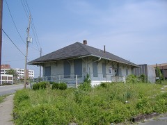 | Spring Street Freight House | 0.5 miles | 2007 |
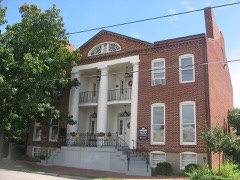 | Grisamore House | 0.8 miles | 1983 |
| Patterson Place Historic District | 0.8 miles | 2023 | |
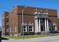 | Old Jeffersonville Historic District | 1.0 miles | 1987 |
| Clark-McKinley Historic District | 1.3 miles | 2023 |
| National Archives record | The nomination case file for reference 100003501 in Record Group 79. |
| Clark County | All 19 listed properties in this county. |