 Block
From the record
One of 13 National Register listings published here for Henry County · listed in 2019 · category: Site.
Sources: the National Register database, National Park Service
Listed on the National Register of Historic Places in 2019.
One of 13 National Register listings published here for Henry County · listed in 2019 · category: Site.
Sources: the National Register database, National Park Service
The chapter on Wayne Township in History of Henry County, Indiana : Together with Sketches of Its Cities, Villages, and Towns ... Also a Condensed History of Indiana, Embracing Accounts of Pre-historic Races, Aborigines, Winnebago and Black Hawk Wars, and a Brief Review of Its Civil and Political History., published 1884 names Knightstown. This is what it says, exactly as the scans read.
Wayne Township, forming the southwestern corner of Henry County, has an undulating surface, good soil and excellent farming lands. It was settled early 'and has been steadily progressive and prosperous. It contains the wealthy town of Knightstown, and other villages of less importance which are mentioned hereafter. It is watered by Blue River, Montgomery Creek, Buck Creek and Six-Mile Creek.
Passage source: History of Henry County, Indiana : Together with Sketches of Its Cities, Villages, and Towns ... Also a Condensed History of Indiana, Embracing Accounts of Pre-historic Races, Aborigines, Winnebago and Black Hawk Wars, and a Brief Review of Its Civil and Political History., published 1884.
In 1825 the commissioners directed that elections for Wayne Township be held in future at the house of Prudence Jackson. In November, 1827, the place of election was changed from Mrs. Jackson's to Solomon Byrkett's; J^cpb Parkhurst's house, Raysville, and then Knightstown became successively the election place of the township. The township officers in 1822 were: Elijah Mc- Cray, E. Hardin and Daniel Priddy, Constables; Ebenezer Goble and Samuel Furgason, Overseers of the Poor; Daniel Heaton, Shaphet McCray and Jacob Parkhurst, Fence Miewers.
Passage source: History of Henry County, Indiana : Together with Sketches of Its Cities, Villages, and Towns ... Also a Condensed History of Indiana, Embracing Accounts of Pre-historic Races, Aborigines, Winnebago and Black Hawk Wars, and a Brief Review of Its Civil and Political History., published 1884.
Machine-read from a century-old scan, so expect the errors a machine makes: misspelled names, dropped words, stray characters.
Read the whole chapter on Wayne Township - 22,216 words on its settlement, mills, schools and churches.
Regional context, not property-specific evidence. The federal mineral resources record lists 1 working within 5 miles of Knightstown, Old, and Glen Cove Cemeteries: 1 past producer. None of them still produces. What was taken out: Sand and Gravel, Construction. Distance is straight-line from the map coordinates, so a quarry counted here may appear on a neighbouring settlement's page as well.
| Where | Site | Commodity | Status | Recorded |
|---|---|---|---|---|
| Omar V. Davis Pit | Sand and Gravel, Construction | Past Producer |
Regional context, not property-specific evidence. The National Weather Service names Knightstown, the town this property stands in, in 15 storm reports between 1994 and 2025: 11 thunderstorm wind, 3 hail, 1 flash flood. No death or injury is recorded in these reports. Each account below is quoted exactly as the forecast office filed it, from the NOAA Storm Events Database, and each date opens the federal record of that event.
| When | Event | Place named | Harm | What the report says |
|---|---|---|---|---|
| April 2025 | Flash Flood | Knightstown | $50,000 | Numerous roads closed across the county due to heavy rains. Culverts were washed out. Total rainfall ranged from 2.6 to 3.1 inches. |
| May 2008 | Thunderstorm Wind | Knightstown | $20,000 | Two trucks, a trailer, camper, and a Bobcat were damaged from thunderstorm winds that moved through Knightstown. |
| June 2007 | Thunderstorm Wind | Knightstown | $12,000 | Law enforcement reported a roof of a house was damaged at 625 W and U.S. 40. Also, trees were blown down onto a house near Raysville. |
| April 2020 | Thunderstorm Wind | Knightstown | $10,000 | Picture received of uprooted tree that had fallen on a car due to thunderstorm wind gusts. Relayed via twitter. |
| May 2008 | Thunderstorm Wind | Knightstown | $5,000 | A house sustained damage due to damaging thunderstorm winds. Six to seven inch tree limbs were down and there was no power in town due to the storm. |
| May 2011 | Thunderstorm Wind | Knightstown | $3,000 | An eight inch diameter tree branch was reported down on a car due to damaging thunderstorm wind gusts. |
| June 2016 | Thunderstorm Wind | Knightstown | $1,000 | A fence was blown down due to damaging thunderstorm wind gusts. Large tree limbs were also downed. |
| May 2011 | Thunderstorm Wind | Knightstown | - | A 60 mph thunderstorm wind gust was reported in this location. |
| July 2006 | Hail | Knightstown | - | No property damage reported. |
| April 1994 | Thunderstorm Wind | Knightstown | - | A thunderstorm blew a tree down onto a house, barn, and garage in Knightstown. A large commercial-use garage was demolished by straight line winds. |
| May 2011 | Hail | Knightstown | - | no account filed |
| May 2008 | Thunderstorm Wind | Knightstown | - | no account filed |
| July 2006 | Hail | Knightstown | - | no account filed |
| May 2003 | Thunderstorm Wind | Knightstown | - | no account filed |
| June 2001 | Thunderstorm Wind | Knightstown | - | no account filed |
No historic map-sheet match is published for this property yet. That does not mean no map exists. This record needs a coordinate-quality review before it can be joined to a sheet boundary. Browse the county's mapped places while that work is pending.
Other National Register properties close enough to walk or drive between, ordered by distance from this one. Both positions come from the same geocoding pass that matched these properties to their map sheets.
| Photograph | Property | Distance | Listed |
|---|---|---|---|
 | Knightstown Academy | 0.5 miles | 1976 |
 | Knightstown Historic District | 0.6 miles | 1986 |
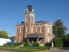 | Elias Hinshaw House | 0.6 miles | 1984 |
| National Archives record | The nomination case file for reference 100004046 in Record Group 79. |
| Henry County | All 13 listed properties in this county. |