 Block
From the record
One of 19 National Register listings published here for Jackson County · listed in 2020 · category: District.
Sources: the National Register database, National Park Service
Listed on the National Register of Historic Places in 2020.
One of 19 National Register listings published here for Jackson County · listed in 2020 · category: District.
Sources: the National Register database, National Park Service
Regional context, not property-specific evidence. The National Weather Service names Seymour, the town this property stands in, in 70 storm reports between 1994 and 2026: 36 thunderstorm wind, 14 hail, 10 flood, 4 tornado. The reports record 2 deaths and 9 injuries. Each account below is quoted exactly as the forecast office filed it, from the NOAA Storm Events Database, and each date opens the federal record of that event.
| When | Event | Place named | Harm | What the report says |
|---|---|---|---|---|
| April 1996 | Thunderstorm Wind | Seymour | 2 killed, $50,000 | no account filed |
| June 2006 | Tornado (F1) | Seymour | 4 hurt, $400,000 | An F1 tornado touched down in eastern Jackson County on the evening of 7 June 2006, damaging or destroying a double wide trailer, a restaurant, four other homes, and numerous large trees. |
| March 2012 | Lightning | Seymour | 4 hurt | Four Seymour teens were injured by a lightning strike during softball practice. The strike happened about 4:14 P.M. EDT at Seymour High School. |
| May 2001 | Thunderstorm Wind | Seymour | 1 hurt | no account filed |
| May 1996 | Tornado (F2) | Seymour | $1,300,000 | no account filed |
| April 2006 | Tornado (F1) | Seymour | $200,000 | Several homes were damaged by a brief tornado in Seymour on 2 April 2006. |
| April 1996 | Tornado (F0) | Seymour | $150,000 | no account filed |
| June 2023 | Thunderstorm Wind | Seymour | $100,000 | Roof damage and a collapsed chimney in Seymour caused by thunderstorm wind gusts. Over 3500 power outages caused by the storm. |
| May 2022 | Thunderstorm Wind | Seymour | $50,000 | Thunderstorm straight-line winds caused significant damage at Kasting Park. Baseball dugout had roof lifted off and cinder block wall knocked down. Aluminum bleachers were blown into stadium's fence. Only minor siding damage to onsite building. Damage was all laid out to the north and northeast. |
| May 2002 | Flash Flood | Seymour | $50,000 | no account filed |
| March 2022 | Thunderstorm Wind | Seymour | $30,000 | Thunderstorm winds caused extensive damage from near Courtland into west side of Seymour with everything blown to the east. A metal storage barn had sheet metal ripped off and many trees were blown down. |
| October 2016 | Flood | Seymour | $30,000 | Major street flooding was reported with multiple vehicles stranded and a car lot flooding due to heavy thunderstorm rainfall of over four inches. |
| May 1996 | Lightning | Seymour | $30,000 | no account filed |
| March 2026 | Thunderstorm Wind | Seymour | $10,000 | Multiple trees downed by thunderstorm wind gusts. |
| July 2012 | Thunderstorm Wind | Seymour | $10,000 | A transformer was blown off a utility pole and was on fire due to damaging thunderstorm wind gusts. Some railroad crossing arms were broken off on U.S. Highway 50. Also, numerous traffic lights and trees were broken. |
| June 2008 | Thunderstorm Wind | Seymour | $10,000 | Trees and power lines were blown down due to damaging thunderstorm winds. Roof damaged also occurred to a home. |
| February 2007 | Flood | Seymour | $10,000 | The East Fork White flooded in Jackson County during the latter portion of February. The river would remain above flood stage through the end of the month, and would eventually crest nearly 5 feet above flood stage. |
| March 2007 | Flood | Seymour | $10,000 | The East Fork White River in Jackson County continued to remain above flood during early March. Crests were nearly 5 feet above flood stage. |
| January 2007 | Flood | Seymour | $10,000 | Save for brief drops below flood stage, the East Fork White at Seymour remained above flood stage through much of January. The river reached as high as 6.4 feet above flood stage. |
| December 2006 | Flood | Seymour | $10,000 | The East Fork White River flooded in Jackson County due to heavy rain. The river crested at over 5 feet above flood stage. |
| June 2008 | Thunderstorm Wind | Seymour | $9,500 | A business on Killion Avenue in the Eastside Industrial Park had a section of the roof and a garage door blown off by thunderstorm winds. Utility lines in the area were also down. Power outages occurred across Seymour. |
| March 2017 | Thunderstorm Wind | Seymour | $8,000 | Utility lines were downed and a power station was on fire near the 10th and North Obrien Streets intersection due to damaging thunderstorm wind gusts. |
| July 1997 | Lightning | Seymour | $8,000 | Lightning triggered a fire at the Canterbury Apartments in Seymour. |
| June 2010 | Thunderstorm Wind | Seymour | $7,000 | Several trees were reported down in Seymour. |
| January 2008 | Thunderstorm Wind | Seymour | $7,000 | A tree fell on a house due to damaging thunderstorm winds. |
| May 2018 | Thunderstorm Wind | Seymour | $5,000 | Numerous tree limbs and power lines were downed across Seymour due to damaging thunderstorm wind gusts. Winds were estimated at 50 to 60 mph. |
| January 2008 | Flash Flood | Seymour | $5,000 | Heavy rain caused flash flooding across Jackson County. This caused many roads to flood and close. Some locations that were closed include State Road 258 at 110 East and State Road 258 between Cortland and Freetown. One motorist had to be rescued from his vehicle after he was caught in floodwaters west of Cortland. Another two vehicles were reported stranded west of Cortland in flood waters. |
| January 2008 | Flash Flood | Seymour | $5,000 | Heavy rain caused flash flooding throughout the county. Water was as high as two feet over some roadways. Multiple roads were closed across the county. |
| July 2020 | Thunderstorm Wind | Seymour | $4,000 | Numerous trees were downed due to thunderstorm wind gusts across the county but no specific locations were noted. |
| June 1998 | Thunderstorm Wind | Seymour | $4,000 | Thunderstorm winds blew down trees and power lines. One tree crushed a pickup truck. |
| July 2015 | Thunderstorm Wind | Seymour | $3,000 | Trees and power lines were downed near Steak 'n Shake on Route 50 due to damaging thunderstorm wind gusts. |
| July 2008 | Thunderstorm Wind | Seymour | $2,500 | Trees and utility lines were blown down by thunderstorm winds. |
| July 1997 | Thunderstorm Wind | Seymour | $2,000 | Thunderstorm winds blew down trees and power lines on Seymour's north side. |
| May 1995 | Thunderstorm Wind | Seymour | $2,000 | Trees and power lines were downed. |
| May 1996 | Thunderstorm Wind | Seymour | $1,500 | no account filed |
| June 2025 | Thunderstorm Wind | Seymour | $1,000 | Thunderstorm wind gusts downed a tree or large tree branch. |
| April 2017 | Flood | Seymour | $1,000 | Highway 50 at Burkhart Boulevard was closed due to flooding from heavy thunderstorm rainfall. |
| March 2007 | Flood | Seymour | $1,000 | The East Fork White River rose above flood stage again in mid-March, reaching heights just over 2 feet above flood. |
| March 2007 | Flood | Seymour | $1,000 | The East Fork White in Jackson County flooded for the third time in March. Crests were slightly more than two feet above flood. |
| November 1996 | Thunderstorm Wind | Seymour | $1,000 | no account filed |
| June 2010 | Flood | Seymour | $750 | Two feet of water was reported over the intersection of 4th Street and Jackson Street. |
| January 2012 | Thunderstorm Wind | Seymour | $500 | Tree limbs were reported down in Seymour due to damaging thunderstorm wind gusts. |
| January 2012 | Flood | Seymour | $500 | Standing water was observed in Seymour due to heavy thunderstorm rainfall. |
| August 1997 | Thunderstorm Wind | Seymour | $500 | Thunderstorm winds blew down large rotted tree at East Tipton Street. |
| April 2009 | Hail | Seymour | - | Quarter size hail estimated to have fallen in Seymour, Indiana. |
| April 2009 | Hail | Seymour | - | Nickel size hail reported at county road 400 north and highway 50 near Seymour. |
| February 2008 | Thunderstorm Wind | Seymour | - | Downtown Seymour was without power due to damaging thunderstorm winds. |
| September 2007 | Thunderstorm Wind | Seymour | - | Power lines were reported down just north of I-65 and SR 11 due to damaging thunderstorm winds. |
| May 2005 | Thunderstorm Wind | Seymour | - | Trees were downed near Seymour. |
| March 2025 | Hail | Seymour | - | no account filed |
| June 2019 | Hail | Seymour | - | no account filed |
| May 2019 | Hail | Seymour | - | no account filed |
| August 2014 | Hail | Seymour | - | no account filed |
| April 2010 | Thunderstorm Wind | Seymour | - | no account filed |
| June 2006 | Hail | Seymour | - | no account filed |
| April 2005 | Hail | Seymour | - | no account filed |
| April 2005 | Hail | Seymour | - | no account filed |
| July 2004 | Hail | Seymour | - | no account filed |
| July 2004 | Thunderstorm Wind | Seymour | - | no account filed |
| April 2003 | Thunderstorm Wind | Seymour | - | no account filed |
No historic map-sheet match is published for this property yet. That does not mean no map exists. This record needs a coordinate-quality review before it can be joined to a sheet boundary. Browse the county's mapped places while that work is pending.
Other National Register properties close enough to walk or drive between, ordered by distance from this one. Both positions come from the same geocoding pass that matched these properties to their map sheets.
| Photograph | Property | Distance | Listed |
|---|---|---|---|
 | T. Harlan and Helen Montgomery House | 0.1 miles | 2010 |
 | First Presbyterian Church | 0.2 miles | 1991 |
 | George H. Vehslage House | 0.2 miles | 2010 |
 | Farmers Club | 0.3 miles | 1983 |
 | Seymour Commercial Historic District | 0.4 miles | 1995 |
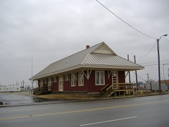 | Southern Indiana Railroad Freighthouse | 0.4 miles | 2003 |
| National Archives record | The nomination case file for reference 100005044 in Record Group 79. |
| Jackson County | All 19 listed properties in this county. |