 Block
From the record
One of 37 National Register listings published here for Carroll County · listed in 2021 · category: Structure · built in 1872.
Sources: the National Register database, National Park Service
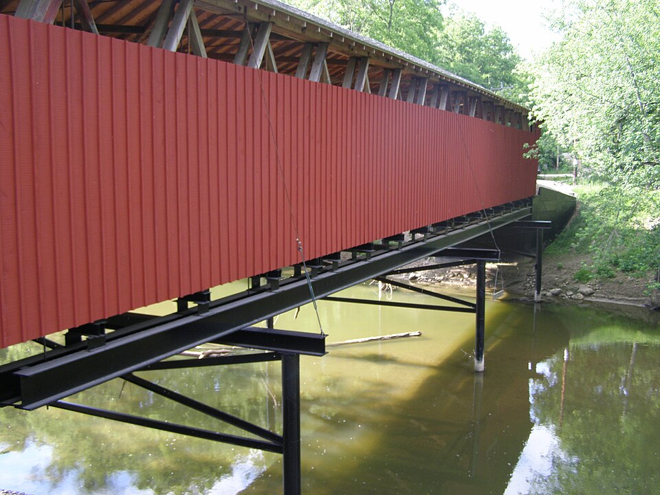
Built in 1872. Listed on the National Register of Historic Places in 2021.
One of 37 National Register listings published here for Carroll County · listed in 2021 · category: Structure · built in 1872.
Sources: the National Register database, National Park Service
The chapter on Clay Township in History of Carroll County Indiana, published 1916 names Owasco. This is what it says, exactly as the scans read.
Clay township was organized by the board of county commissioners in 1831, and Albert G. Hanna was appointed inspector of elections. The first election was held at the house of Jonathan Gillam, on the second Mon¬ day of April, 1831, and George Julian was elected justice of the peace. This township is the southwest township of the county. Wild Cat creek runs through this township. ( The first school house was built on the farm of Alexander Murphy in 1837 and a Mr. Troxell taught the first school. The next school house was built on the land of John Beard in 1839. Log school houses were built thereafter as the demands of the people required. Two churches of the German Baptist denomination are located in this township. John Wagoner erected the first saw-mill, and also a mill to grind wheat and com. The villages in this township, are Pyrmont and Owasco. Pyrmont is situated on the western border, and Owasco on the Monon rail¬ road.
Passage source: History of Carroll County Indiana, published 1916.
Machine-read from a century-old scan, so expect the errors a machine makes: misspelled names, dropped words, stray characters.
Read the whole chapter on Clay Township - 165 words on its settlement, mills, schools and churches.
Regional context, not property-specific evidence. The federal wildfire occurrence database lists 1 fire within 5 miles of Lancaster Covered Bridge in 2007, burning under an acre in total. 1 started naturally. None was recorded as arson. Distance is straight-line from the map coordinates, so a fire counted here may appear on a neighbouring settlement's page as well.
| Reported cause | Fires |
|---|---|
| Natural | 1 |
The most recent of them, most recent first, with the day each was reported and the service that recorded it.
| Date | Cause | Size | Reported by | Name on the report |
|---|---|---|---|---|
| 15 May 2007 | Natural | under an acre | Indiana State Fire Marshal's Office | not named |
Regional context, not property-specific evidence. The federal mineral resources record lists 2 workings within 5 miles of Lancaster Covered Bridge: 1 past producer, 1 unknown. None of them still produces. What was taken out: Sand and Gravel, Construction. Distance is straight-line from the map coordinates, so a quarry counted here may appear on a neighbouring settlement's page as well.
| Where | Site | Commodity | Status | Recorded |
|---|---|---|---|---|
| Barnard Pit | Sand and Gravel, Construction | Past Producer | ||
| Skiles Pit | Sand and Gravel, Construction | Unknown |
Regional context, not property-specific evidence. The National Weather Service names Owasco, the town this property stands in, in 3 storm reports between 2012 and 2013: 1 thunderstorm wind, 1 flood, 1 tornado. No death or injury is recorded in these reports. Each account below is quoted exactly as the forecast office filed it, from the NOAA Storm Events Database, and each date opens the federal record of that event.
| When | Event | Place named | Harm | What the report says |
|---|---|---|---|---|
| November 2013 | Tornado (EF1) | Owasco | $30,000 | At 1454EST, this EF-3 tornado touched down 5 miles south-southeast of Lafayette. This EF-3 tornado impacted the Subaru and Voest Alpine plants southeast of Lafayette. Both sustained significant damage consistent with a low end EF-3 rating. Property and tree damage then continued northeast to the north of Dayton. The tornado crossed through the far northwest corner of Clinton County causing mainly EF-0 tree damage. Then, the tornado moved into southwest Carroll county. A hog farm sustained damage to several outbuildings in extreme southwest Carroll County. Additional damage was found in Cutler. Much of the damage across Carroll County ranged between EF-0 and EF-1. This tornado crossed into Cass County near State Route 18 at 1517EST, continuing for nearly an additional 10 miles. The total path length including Cass County is 39 miles. The tornado lifted 4 miles southwest of Grissom Air Reserve Base at 1527EST. |
| August 2012 | Thunderstorm Wind | Owasco | $1,500 | Tree limbs, two to three inches in diameter, and power lines were downed along County Road 700 South due to damaging thunderstorm wind gusts. |
| April 2013 | Flood | Owasco | $500 | Water was reported over the road near State Road 39 and County Road 700 South due to heavy thunderstorm rainfall. This occurred near Wildcat Creek. |
No historic map-sheet match is published for this property yet. That does not mean no map exists. This record needs a coordinate-quality review before it can be joined to a sheet boundary. Browse the county's mapped places while that work is pending.
Other National Register properties close enough to walk or drive between, ordered by distance from this one. Both positions come from the same geocoding pass that matched these properties to their map sheets.
| Photograph | Property | Distance | Listed |
|---|---|---|---|
 | Adams Mill Covered Bridge | 5.6 miles | 1996 |
 | Adams Mill | 5.8 miles | 1984 |
| Carroll County Infirmary | 6.8 miles | 2018 | |
 | Baum-Shaeffer Farm | 7.6 miles | 1998 |
| National Archives record | The nomination case file for reference 100006206 in Record Group 79. |
| Carroll County | All 37 listed properties in this county. |