Block
From the record
37 National Register listings published here.
Sources: the county history on the Internet Archive · the National Register database, National Park Service
27 topographic sheets cover 40 settlements here, and 37 properties are on the National Register of Historic Places.
37 National Register listings published here.
Sources: the county history on the Internet Archive · the National Register database, National Park Service
Every property in this county listed on the National Register of Historic Places, with the year it was listed and the federal nomination document.
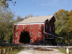
Carroll County has 2 covered bridges on the National Register. Each is a listed structure with a federal nomination on file.
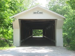 | Adams Mill Covered Bridge | Listed 1996 |
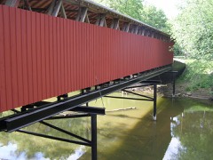 | Lancaster Covered Bridge | Listed 2021 |
Every wildfire the federal occurrence database records inside this county: 7 of them, burning about 9 acres. 1 started naturally and none was recorded as arson. Each settlement page carries the fires within five miles of it.
| Reported cause | Fires |
|---|---|
| Missing data/not specified/undetermined | 3 |
| Recreation and ceremony | 2 |
| Natural | 1 |
| Debris and open burning | 1 |
The five largest, by the area the report gives. None of them was recorded as arson.
| Date | Cause | Size | Reported by | Name on the report |
|---|---|---|---|---|
| 6 April 2008 | Recreation and ceremony | 7.0 acres | Indiana State Fire Marshal's Office | not named |
| 16 March 2008 | Recreation and ceremony | 1.0 acres | Indiana State Fire Marshal's Office | not named |
| 22 May 2007 | Missing data/not specified/undetermined | under an acre | Indiana State Fire Marshal's Office | not named |
| 15 May 2007 | Natural | under an acre | Indiana State Fire Marshal's Office | not named |
| 5 February 2008 | Missing data/not specified/undetermined | under an acre | Indiana State Fire Marshal's Office | not named |
| 13 September 2007 | Missing data/not specified/undetermined | under an acre | Indiana State Fire Marshal's Office | not named |
| 8 August 2007 | Debris and open burning | under an acre | Indiana State Fire Marshal's Office | not named |
Every settlement page carries the fires within five miles of it - see the settlement index below.
The NOAA Storm Events Database holds 245 reports for this county, causing 2 deaths, 5 injuries and about $24,764,900 in recorded property damage. Each settlement page carries the reports that name it.
| Kind of event | Reports |
|---|---|
| Thunderstorm Wind | 141 |
| Hail | 51 |
| Tornado | 20 |
| Flash Flood | 18 |
| Flood | 11 |
| Lightning | 3 |
| Heavy Rain | 1 |
The most serious of them, by death, then injury, then recorded damage. The accounts are quoted exactly as the forecast office filed them.
| When | Event | Place named | Harm | What the report says |
|---|---|---|---|---|
| July 2003 | Flash Flood | Countywide | 2 killed, $7,000,000 | no account filed |
| March 1976 | Tornado (F4) | not stated | 2 hurt, $2,500,000 | no account filed |
| June 2010 | Tornado (EF1) | Yoeman | 2 hurt, $400,000 | Numerous structures were damaged along the path of this tornado, including several homes, a church, and at least 13 barns. Some of the more significant damage occurred at US Highway 421 and County Road 875 N, with the church receiving roof damage and a boat storage facility having a structure destroyed. This tornado also caused some minor damage to the facility that hosts the transmitter for the NOAA Weather Radio that serves the Lafayette area, WXK-74. The generator on site was damaged. Numerous trees were downed as well. Based on the damage, it appears this was an EF1 tornado with winds near 100 mph. A couple of minor injuries were reported by WLFI. |
| May 1977 | Tornado (F1) | not stated | 1 hurt, $25,000 | no account filed |
| January 2008 | Flood | Yoeman | $12,000,000 | Record flooding occurred along the Tippecanoe River downstream of Oakdale Dam in Carroll County due to heavy rain and snow melt. At least 330 homes in Carroll County met preliminary qualifications to be considered destroyed. |
| February 2008 | Flood | Yoeman | $750,000 | Flooding occurred along the Tippecanoe River downstream of Oakdale Dam in Carroll County due to heavy rain and snow melt. |
| February 2008 | Flood | Pittsburg | $500,000 | Flooding occurred along the Tippecanoe River in Carroll County, including west of Delphi, due to heavy rain and snow melt. |
| June 1992 | Tornado (F1) | not stated | $250,000 | no account filed |
| May 2009 | Flood | Flora | $125,000 | Between Flora and Delphi, Indiana several roads and bridges were badly damaged by flood water. Damage cost is grossly estimated. |
| May 2009 | Lightning | Flora | $100,000 | Abundant lightning strikes associated with a squall line apparently started a house fire at approximately 2223 EST in Flora, Indiana. Three occupants apparently were unable to escape and perished in the fire. |
| June 2021 | Tornado (EF1) | Pyrmont | $97,500 | A National Weather Service damage survey found the first tornado of the episode was an EF1 with maximum winds of 95 mph and a path length of 2.17 miles, which included both Tippecanoe and Carroll Counties. Upon the tornado crossing into Carroll County, a farm on the east side of County Line Road had a barn roof lifted and the west wall collapsed. The tornado continued on a northeast path to just north of the intersection of county road 700 S and 800 W where another farm was hit with the roof and sides of two barns thrown to the north and west. This appears to be where this tornado ended. Damage at both of these locations was consistent with an EF1 and winds up to 95|mph. |
| June 2001 | Lightning | Flora | $70,000 | no account filed |
| June 2010 | Tornado (EF1) | Deer Creek | $60,000 | A trained spotter reported a tornado silhouetted by lightning in this location. This tornado touched down near County Road 700 N and 500 E in eastern Carroll County around 1:25 AM EDT. Two hog barns were destroyed in the path of this tornado before continuing on into Cass County. Based on the damage observed, this appeared to be a high EF1 tornado with winds approaching 110 mph. |
| May 2024 | Thunderstorm Wind | Lexington | $50,000 | A hog barned was damaged by a locally stronger thunderstorm wind gust. |
| April 2020 | Thunderstorm Wind | Delphi | $50,000 | Emergency manager reports numerous power lines were knocked down due to thunderstorm wind gusts. Trees and tree limbs of unknown size were also snapped. |
| May 2024 | Thunderstorm Wind | Burlington | $40,000 | Tree downed by thunderstorm wind gusts onto a house. Other trees in the yard snapped. |
| May 2022 | Thunderstorm Wind | Sharon | $30,000 | Thunderstorm winds removed the roof from a large metal garage and deposited it a short distance away. |
| November 2013 | Tornado (EF1) | Owasco | $30,000 | At 1454EST, this EF-3 tornado touched down 5 miles south-southeast of Lafayette. This EF-3 tornado impacted the Subaru and Voest Alpine plants southeast of Lafayette. Both sustained significant damage consistent with a low end EF-3 rating. Property and tree damage then continued northeast to the north of Dayton. The tornado crossed through the far northwest corner of Clinton County causing mainly EF-0 tree damage. Then, the tornado moved into southwest Carroll county. A hog farm sustained damage to several outbuildings in extreme southwest Carroll County. Additional damage was found in Cutler. Much of the damage across Carroll County ranged between EF-0 and EF-1. This tornado crossed into Cass County near State Route 18 at 1517EST, continuing for nearly an additional 10 miles. The total path length including Cass County is 39 miles. The tornado lifted 4 miles southwest of Grissom Air Reserve Base at 1527EST. |
| January 2008 | Flash Flood | Yoeman | $30,000 | Flash Flooding closed several roads adjacent to the Tippecanoe River, including State Route 18, due to heavy rain and snow melt. A few people had to be rescued off the roofs of their houses. |
| February 2008 | Flash Flood | Yoeman | $30,000 | Flash flooding occurred downstream of Oakdale Dam in Carroll County due to heavy rain and snow melt. Numerous homes were destroyed and evacuations occurred. |
| June 1996 | Lightning | Delphi | $30,000 | no account filed |
| March 2025 | Thunderstorm Wind | Delphi | $25,000 | A few structures sustained minor damage caused by thunderstorm winds across the county with a centralized location near Delphi. |
| June 2021 | Tornado (EF0) | Carrollton | $25,000 | A National Weather Service damage survey found the second tornado of the event was spawn from the same supercell. The storm had continued moving northeast across large expanses of corn and bean fields as well as wooded areas. No additional damage could be found from the ground until just east of county road 500 E along 100 S where the second tornado began and brushed the corner of a wooded lot and home. This tornado was an EF0 with winds of 70 to 74 mph and a path length of 2.35 miles. The damage was primarily snapping of the tops of trees along its path. The first damage found included several trees that were snapped towards the top with large limbs broken and brought down to the northeast, but a few large limbs were convergent into the path of this tornado and pointing southeast. Marks on the ground indicated some of the larger limbs had been pulled southeast. This tornado again appeared to dissipate but quickly start again multiple times along its path. This is consistent with spotter and|eyewitness reports. Several points surveyed showed mainly tree damage and some minor shingle or siding damage to homes. This tornado ended just south of county road 100 N about halfway between 600 E and SR 18 in Carroll County. |
| July 2021 | Thunderstorm Wind | Bringhurst | $25,000 | Tv media received a photograph from a viewer of metal roofing removed from a small barn by thunderstorm wind gusts. The viewer also reported small limbs down. |
| April 2006 | Tornado (F0) | Radnor | $25,000 | A weak tornado touched down near Americus and moved eastward, lifting shortly after entering Carroll County. Damage was confined to farm outbuildings. |
| August 1975 | Tornado (F0) | not stated | $25,000 | no account filed |
| April 1963 | Tornado (F3) | not stated | $25,000 | no account filed |
| March 1956 | Tornado (F2) | not stated | $25,000 | no account filed |
| March 2025 | Thunderstorm Wind | Delphi | $20,000 | Dozens of trees downed by thunderstorm wind gusts near Delphi and points to the northeast. |
| June 2012 | Thunderstorm Wind | Pyrmont | $20,000 | Trees and power lines were reported down at several spots across Carroll county due to damaging thunderstorm wind gusts. Time and location was estimated from radar data. |
| July 2011 | Flash Flood | North Delphi | $20,000 | Several culverts were washed out on County Roads between Delphi and the Tippecanoe River due to over 5 inches of thunderstorm rainfall. |
| June 2010 | Thunderstorm Wind | Yoeman | $20,000 | Trees, home siding, and roofing material were reported to have fallen on Pirates Roost Road. |
| July 2012 | Thunderstorm Wind | Flora | $17,000 | Numerous reports of a downed transformer, downed power lines, and downed trees around the Flora area due to damaging thunderstorm wind gusts. A roof was also blown off a chicken coop. Power was out in Flora at the time of observation. |
| August 2018 | Thunderstorm Wind | Burlington | $15,000 | A barn roof was torn off, multiple large trees were downed, and a power line was down due to damaging thunderstorm wind gusts. |
| March 2009 | Thunderstorm Wind | Flora | $15,000 | Thunderstorm winds blew the roof off of a building and downed trees and utility lines. Estimated damage cost is very rough. |
| November 2005 | Thunderstorm Wind | Flora | $15,000 | A pole barn was destroyed. |
| May 2000 | Thunderstorm Wind | Patton | $15,000 | Highway department reported trees and power lines down from just north of Patton to Burrows. Also, law enforcement roof and barn damage near Delphi. |
| August 2014 | Thunderstorm Wind | Harley | $12,000 | Trees were downed from Delphi to Frankfort due to damaging thunderstorm wind gusts. Duke Energy reported numerous service calls because of this. |
| June 2010 | Thunderstorm Wind | Wheeling | $12,000 | A semi-trailer was reported to be blown into a ditch due to thunderstorm wind gusts. |
| July 2021 | Flash Flood | Radnor | $10,000 | Water was estimated to be 6 to 8 inches deep on State Road 18 between County Roads 300 East and 350 East. Water was also estimated to be 5 to 6 inches and deep flowing across County Road 350 East just south of State Road 18. |
| May 1998 | Thunderstorm Wind | Burrows | $10,000 | Tstm winds took out 6 power lines and power substation. |
| September 1999 | Thunderstorm Wind | Radnor | $10,000 | no account filed |
| May 2019 | Thunderstorm Wind | Pyrmont | $9,000 | A patio door was blown into a family room of a home due to damaging thunderstorm wind gusts. Trees and utility lines were blown down as well. A swing set was overturned. |
| June 2011 | Thunderstorm Wind | Yoeman | $9,000 | Numerous power lines and trees were reported to be down on roadways in the Oakdale Dam area due to damaging thunderstorm wind gusts. |
| June 2011 | Thunderstorm Wind | Delphi | $9,000 | Numerous power lines and trees were downed on roadways due to damaging thunderstorm wind gusts. |
| June 2010 | Thunderstorm Wind | Yoeman | $9,000 | Partial roof damage to a church was reported in Yeoman. Tree limbs were also reported down in town and to the northwest of town. |
| August 2009 | Thunderstorm Wind | Sleeth | $8,000 | Numerous trees were knocked down due to thunderstorm winds as the bow echo pushed across the area. Power lines due to trees laying on them. |
| June 2010 | Thunderstorm Wind | Deer Creek | $7,500 | A roof was reportedly blown off a barn due to thunderstorm wind gusts. |
| August 2016 | Tornado (EF1) | Carrollton | $7,000 | This EF-1 tornado, with maximum wind speeds of 110 mph, caused several barns to sustain partial wall and roof damage. One garage slid off its foundation. Tree damage throughout the path. The path continued into northwest Howard County. |
| May 2013 | Thunderstorm Wind | Bringhurst | $7,000 | Trees and power lines were reported down due to damaging thunderstorm wind gusts. |
| July 2011 | Thunderstorm Wind | Rockfield | $7,000 | Several trees were reported down near Borrows and Lockport due to damaging thunderstorm wind gusts. |
| June 2011 | Thunderstorm Wind | Burlington | $6,000 | Numerous trees and power lines were down on roadways due to damaging thunderstorm wind gusts. |
| May 2011 | Thunderstorm Wind | Cutler | $6,000 | Several large trees were reported down with one blocking State Route 75 due to damaging thunderstorm wind gusts. |
| June 2004 | Flash Flood | Countywide | $6,000 | no account filed |
| December 2021 | Thunderstorm Wind | Flora | $5,000 | Numerous trees and power lines down by thunderstorm wind gusts across Carroll County. |
| May 2019 | Flash Flood | Burlington | $5,000 | County Dispatch reported several roads in Burlington had water flowing over them with a focus on the south side of town due to heavy thunderstorm rainfall. |
| June 2014 | Thunderstorm Wind | Pittsburg | $5,000 | A spotter reported trees down on Tecumseh Bend Road due to damaging thunderstorm wind gusts. |
| July 2013 | Thunderstorm Wind | Flora | $5,000 | Trees were reported down in the county due to damaging thunderstorm wind gusts. |
| July 2012 | Thunderstorm Wind | Delphi | $5,000 | Trees were downed in Delphi due to damaging thunderstorm wind gusts. |
| July 2011 | Thunderstorm Wind | North Delphi | $5,000 | Trees were downed in this location due to damaging thunderstorm wind gusts. |
The Survey's mineral resources record lists 7 workings inside this county. 5 still produce and 2 are closed or unrecorded. Each settlement page carries the workings within five miles of it.
| Commodity | Workings |
|---|---|
| Sand and Gravel, Construction | 4 |
| Lead, Zinc | 1 |
| Sulfur | 1 |
| Stone | 1 |
| Stone, Crushed/Broken | 1 |
The least common of them first, because a county's hundredth gravel pit says nothing its first ten did not.
| Where | Site | Commodity | Status | Recorded |
|---|---|---|---|---|
| Carroll County Highway Dept. | Stone | Producer | ||
| Delphi Limestone Quarry | Stone, Crushed/Broken | Producer | ||
| Sphalerite Occurrence Z55 | Lead, Zinc, Sulfur | Occurrence | Sphalerite | |
| Munson Pit | Sand and Gravel, Construction | Producer | ||
| Rider Sand and Gravel Pit | Sand and Gravel, Construction | Producer | ||
| Vianco Pit | Sand and Gravel, Construction | Past Producer | ||
| Wallace Pit | Sand and Gravel, Construction | Producer |
History of Carroll County, Indiana : With Illustrations and Biographical Sketches of Some of Its Prominent Men and Pioneers ... devotes a chapter to each township: its boundaries and streams, who settled it and when, the mills, the schools and the churches. All 13 are reproduced here in full. Each row shows the township's own shape and where it lies in the county, drawn from the Census Bureau's boundary. Which settlements belong to which township is computed from that same boundary, not taken from the book.
| Shape and position in the county | Township | Settlements in it | Length | Sections |
|---|---|---|---|---|
| Adams Township | Lockport | 182 words | 0 | |
| Burlington Township | Burlington, Carrollton | 148 words | 0 | |
| Carrollton Township | Sharon, Wheeling | 133 words | 0 | |
| Clay Township | Owasco, Pyrmont | 165 words | 0 | |
| Deer Creek Township | Delphi, Harley, Harley Siding | 11,192 words | 10 | |
| Democrat Township | Adams Mill, Cutler, Lexington, Prince William, Ray | 328 words | 0 | |
| Jackson Township | Camden | 262 words | 0 | |
| Jefferson Township | Breezy Point, C and C Beach, Lower Sunset Park, Patton, Roth Park, Sandy Beach, Scarlet Oaks, Sleeth, Terrace Bay, Upper Sunset Park, Walnut Gardens, Yeoman | 166 words | 0 | |
| Madison Township | Ockley, Radnor | 125 words | 0 | |
| Monroe Township | Bringhurst, Flora | 127 words | 0 | |
| Rock Creek Township | Rockfield | 229 words | 0 | |
| Tippecanoe Township | Pittsburg | 207 words | 0 | |
| Washington Township | Deer Creek | 824 words | 1 |
2 books written about this county, cut here where the book itself is cut, at its printed chapters: 56 chapters in all. Every chapter is public domain, machine-read from the scan and reproduced complete. A chapter already given under one of the county's towns is not repeated in this list.
Named settlements recorded in the Geographic Names Information System, each with the topographic sheets covering it. Villages, hamlets and abandoned places alike. Each is shown with the nearest named watercourse or landform and the survey quadrangle it falls on.
Washington township · 46917 · On Price Plank Ditch · Deer Creek quadrangle
8 sheets, 1953 to 1985
Madison township · 46923 · On Sugar Creek Branch Number One · Pyrmont quadrangle
9 sheets, 1953 to 1984
Tippecanoe township · 46923 · On Tannery Branch · Delphi quadrangle
9 sheets, 1953 to 1985
Madison township · 46923 · On Sugar Creek Branch Number One · Delphi quadrangle
9 sheets, 1953 to 1985