Listed on the National Register of Historic Places in 2013.
From the record
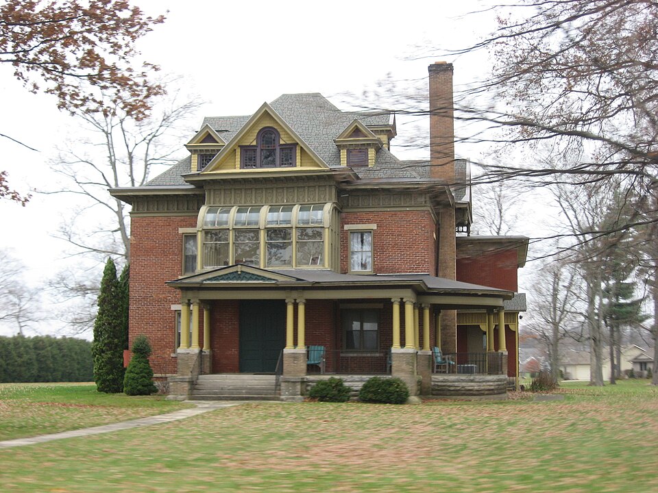
“Haven Hubbard Home, also known as Hamilton Grove, is a historic sanitarium and national historic district located in Olive Township, St. The district encompasses six contributing buildings and one contributing site on a former sanitarium originally developed as a working farm.”
Wikipedia article Haven Hubbard Home, CC BY-SA 4.0.
One of 101 National Register listings published here for St. Joseph County · listed in 2013 · category: District.
National Register reference number. 13000091 - assigned by the National Park Service when the property was listed.
The ground it stands on
11,271 words
The chapter on Olive Township in History of St. Joseph County, Indiana :, published 1880 names New Carlisle. This is what it says, exactly as the scans read.
Among the oldest settlers of Olive township we may mention that man of great memory, Mr. Barvilla Drnliner, of New Carlisle, who was born July 7, 1807; Joseph Adams and wife, of section 31, the oldest couple now living in the township. Mr. A. made his start in the West by splitting rails, at 50 cents per 100, while boarding himself lie has made as many as 500 rails in one day. The young men uf to-day would as soon try Dr. Tanner's experiment of fasting iO days as to make 500 rails in one day. Jacob Kush, who was born in Ohio in 1806, is now living on section 36, one of our oldest pioneers. He held tiie plow for the first furrow ever turned in this township, and he also helped to i-aise the first cabin here, which belonged to his brotiier Israel Hush, who was afterward the first Justice of the Peace, and died in 1837. Jacob is still a lively and energetic man. Asher White was a boy of only 16 years of age when he came here in 1830. His biography is given more in full on a subsequent page.
This part of Indiana was surveyed in 1830 by "William and Noah Brock, the latter running the base lines, and the former dividing the land into sections; and this township received its name in honor of the wife of Charles Vail. She is still living in New Carlisle. Mr. v., who settled here in 1830, was alterward elected County Judge. After the survey of the township, the first Justice of the Peace acted as County Commissioner until the regular annual election.
Regional context, not property-specific
evidence. The
federal wildfire occurrence database
lists 3 fires within 5 miles of Haven Hubbard Home
between 2005 and 2019, burning about 6 acres in total. 1 started naturally. None was recorded as arson.
Distance is straight-line from the map coordinates, so a fire counted
here may appear on a neighbouring settlement's page as well.
Reported cause
Fires
Missing data/not specified/undetermined
2
Natural
1
The most recent of
them, most recent first, with the day each was reported and the service
that recorded it.
Date
Cause
Size
Reported by
Name on the report
10 September 2005
Natural
4.0 acres
Michigan Department of Natural Resources
not named
3 August 2019
Missing data/not specified/undetermined
1.0 acres
Michigan Department of Natural Resources
BERTRAND TOWNSHIP FD 2019066 - 2019
23 December 2019
Missing data/not specified/undetermined
1.0 acres
Michigan Department of Natural Resources
GALIEN TOWNSHIP FD 0000033 - 2019
Storms near this property
19 since 1996
Regional context, not property-specific
evidence. The National Weather Service names
New Carlisle, the town this property stands in, in 19 storm reports between 1996 and 2024: 12 thunderstorm wind, 4 hail, 1 tornado, 1 flood.
No death or injury is recorded in these reports. Each account below is quoted exactly as the forecast office
filed it, from the NOAA Storm Events Database, and each date
opens the federal record of that event.
Local residents south of New Carlisle reported seeing a funnel pass over several rows of trees, causing some damage to the tree tops. The funnel subsequently touched down in an open field and moved rapdily east. A section of an irrigation system was twisted and destroyed in an open field. In addition, strong winds entered an open barn area resulting in much of the roofing material being removed. The winds also weakened the supports causing partial structural failure to a lean-to. A combine in the lean-to sustained some damage. A large tree also fell onto the residence causing some roof damage. Debris was thrown a few hundred feet into an open field. It appears that the tornado lifted shortly after affecting the residence. No injuries occurred with the brief touch down. The irrigation system damages has been estimated at $13,000. Damage estimates to the house and barn are to be determined.
No historic map-sheet match is published
for this property yet. That does not mean no map exists. This record needs
a coordinate-quality review before it can be joined to a sheet boundary.
Browse the county's mapped places while that work is
pending.
Listed places nearby
3 within 8 miles
Other National Register properties close
enough to walk or drive between, ordered by distance from this one. Both
positions come from the same geocoding pass that matched these properties
to their map sheets.
Listing record. National Park Service National Register of Historic Places, listed-properties dataset, current to 2026-05-22.
Map join. Address geocoded through the United States Census geocoder, then tested against the published boundary of every sheet in the USGS Historical Topographic Map Collection.
How this page is made. Listing fields come from federal records; map-sheet coverage is a labelled coordinate-to-boundary calculation, not a source-field claim.
Wildfire. Short, Karen C. 2022. Spatial wildfire occurrence data for the United States, 1992-2020 [FPA_FOD_20221014]. 6th Edition. Fort Collins, CO: Forest Service Research Data Archive. https://doi.org/10.2737/RDS-2013-0009.6 Collected with United States Government funding and usable without additional permissions or fees.
Storms. NOAA National Centers for Environmental Information, Storm Events Database https://www.ncei.noaa.gov/stormevents/ A work of the United States government, no copyright under 17 U.S.C. 105. Narratives are quoted verbatim from the National Weather Service report and are not edited or summarised.
 Block