Listed on the National Register of Historic Places in 2014.
From the record
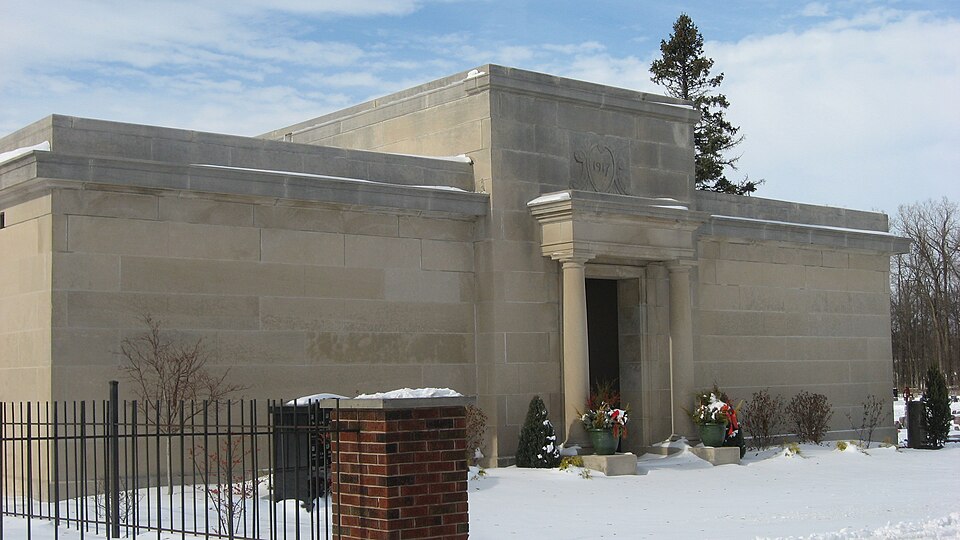
“Auburn Community Mausoleum is a historic mausoleum located in Roselawn Cemetery at Auburn, Indiana. It was built in 1917, and is a one-story, monolithic cubic limestone structure with simple Classical Revival style detail.”
Wikipedia article Auburn Community Mausoleum, CC BY-SA 4.0.
One of 29 National Register listings published here for DeKalb County · listed in 2014 · category: Building.
The township of Union is centrally located, and may be regarded as the most important in the county, due to the location within its limits of Auburn, the county seat. Union township is bounded on the north by Grant township, on the west by Richland and Keyser, on the south by Jackson, and on the east by Wilmington. Cedar creek runs down from the northwest corner, through the township and leaves near the southwest corner. This drains the township very thoroughly, although not many years ago there were several tamarack swamps in it. The northern and western portions of the area are generally rolling and somewhat sandy. The southeastern part is more level, and of a clayey constituency. The Lake Shore & Michigan Southern, the Vandalia of the Pennsylvania system, and the Baltimore & Ohio railroads cross the township at various pomts.
In discussing the first settlement of DeKalb, the most will be written in the history of Auburn, as the pioneer story of that town is practically synonymous with that of the township. Early settlers in the township on farms were: Kneeland Abbott on the south, David Altenburg and Levi Walsworth on the east, and the Husselmans and McEntaffers on the north. Altenburg and Walsworth moved in during November, 1838; James R. Cosper and John Weeks in the spring of 1841 ; and the same year John Somers and Lyman Chidsey settled southeast of Auburn. In the northeast, Rockwell, Lightner and Morringston were the first settlers. Two days were occupied with raising the heavy frame of the Husselman barn, and most of the settlers for miles around were engaged in the work.
Regional context, not property-specific
evidence. The
federal wildfire occurrence database
lists 14 fires within 5 miles of Auburn Community Mausoleum
between 2002 and 2004, burning about 64 acres in total. None started naturally. 3 were recorded as arson.
Distance is straight-line from the map coordinates, so a fire counted
here may appear on a neighbouring settlement's page as well.
Reported cause
Fires
Recreation and ceremony
5
Missing data/not specified/undetermined
3
Arson/incendiarism
3
Debris and open burning
2
Equipment and vehicle use
1
The most recent of
them, most recent first, with the day each was reported and the service
that recorded it.
Regional context, not property-specific
evidence. The federal mineral resources record lists
3 workings within 5 miles of Auburn Community Mausoleum: 1 prospect, 1 producer, 1 past producer.
1 still produces. What was taken out: Sand and Gravel, Construction. Distance is straight-line from the
map coordinates, so a quarry counted here may appear on a neighbouring
settlement's page as well.
Regional context, not property-specific
evidence. The National Weather Service names
Auburn, the town this property stands in, in 43 storm reports between 1994 and 2025: 27 thunderstorm wind, 12 hail, 2 flood, 1 tornado.
The reports record 1 death. Each account below is quoted exactly as the forecast office
filed it, from the NOAA Storm Events Database, and each date
opens the federal record of that event.
Law enforcement officials reported multiple trees down along 7th Street. One of these trees in the 400 block of 7th Street, fell onto a westbound United Parcel Service truck, striking the driver compartment. The 46 year old male driver was killed instantly.
At least 6 roads were temporarily closed, with many others posted with high water signs, as ditches overflowed and low areas filled. A senior care center was threatened by flood waters coming out of a overflown retention pond. Sandbags were placed to help, but luckily no evacuations were needed. No exact damage figure were available, but are estimated at around $150,000.
A mobile home on CR 427 was knocked on its side. Large tree limbs crushed the side of the trailer. A newspaper report stated that a citizens' band radio tower, set in cement, also toppled over and bent across the trailer. At another property across the street several trees were knocked down and two large pine trees were uprooted.
Central dispatch relayed a report of a tree being blown down onto a garage on 9th Street in Auburn. No information on the size or health of the tree and no injuries were reported.
Indiana State Police officials reported a semi-trailer rolled over on Interstate 69, at mile marker 129. No injuries were reported, but northbound lanes were closed for several hours.
A wind gust at DeKalb County Airport was measured at 75 mph. Strong winds split the trunk of a large tree near a house on DeKalb County Road 60, between the DeKalb County Airport and County Road 427. Winds tore the roof off of a barn east of the airport on DeKalb County Road 60 near the Meese Chapel United Methodist Church. Winds also blew down tents that had been set up at Kruse Auction Park in preparation for the Labor Day weekend classic car auction.
No historic map-sheet match is published
for this property yet. That does not mean no map exists. This record needs
a coordinate-quality review before it can be joined to a sheet boundary.
Browse the county's mapped places while that work is
pending.
Listed places nearby
6 within 8 miles
Other National Register properties close
enough to walk or drive between, ordered by distance from this one. Both
positions come from the same geocoding pass that matched these properties
to their map sheets.
Listing record. National Park Service National Register of Historic Places, listed-properties dataset, current to 2026-05-22.
Map join. Address geocoded through the United States Census geocoder, then tested against the published boundary of every sheet in the USGS Historical Topographic Map Collection.
How this page is made. Listing fields come from federal records; map-sheet coverage is a labelled coordinate-to-boundary calculation, not a source-field claim.
Wildfire. Short, Karen C. 2022. Spatial wildfire occurrence data for the United States, 1992-2020 [FPA_FOD_20221014]. 6th Edition. Fort Collins, CO: Forest Service Research Data Archive. https://doi.org/10.2737/RDS-2013-0009.6 Collected with United States Government funding and usable without additional permissions or fees.
Mines and quarries. USGS Mineral Resources Data System (MRDS) https://mrdata.usgs.gov/mrds/ A work of the United States government, no copyright under 17 U.S.C. 105.
Storms. NOAA National Centers for Environmental Information, Storm Events Database https://www.ncei.noaa.gov/stormevents/ A work of the United States government, no copyright under 17 U.S.C. 105. Narratives are quoted verbatim from the National Weather Service report and are not edited or summarised.
 Block