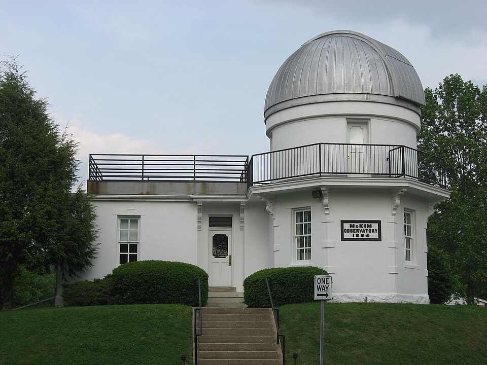
Listed on the National Register of Historic Places in 1978.
From the record
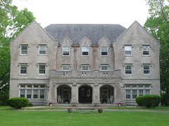
“McKim Observatory is an astronomical observatory owned and operated by DePauw University. Built in 1884, it is located in Greencastle, Indiana, United States.”
Wikipedia article McKim Observatory, CC BY-SA 4.0.
One of 33 National Register listings published here for Putnam County · listed in 1978 · category: Building.
The first child born in Greencastle was j and engaged for awhile in teaching school Columbus D. Seller, son of John F. Seller, I for the neighborhood settled along Little on the 11th of October, 1824. Mary Ann j Walnut. After tho death of his wile, which Glidewell, daughter of Robert Glidewell, ' occurred in a few years, he returned again to was the first ^irl born in the town. She be- | the river. Coming a second time to the came the wife of Isaac Mark, and is still j county in 1830, lie settled in Greencastle, and, in 1835, erected on the present site of the National Bank building the first brick store in town. About the same time he erected a brick house on the corner of Xndi- The next who died there was Benjamin i ana ami Poplar streets. Captain Thornbun? Akers. lie was buried in the old cemetery, j owning the first money-safe in the county, and his grave was the first in that place of I his store became, in effect, a place of deposit, rest. j where spectators, merchants and tanners
Never did the character of Greencastle's citizens show to better advantage than during the year succeeding the tire. Within that time there were made, or ;. early completed, brick and stone improvements to the value of 8252.500, and wooden buildings and repairs worth §98,305, making a total of §350,- 8(35. These works required the consumption of 4,805,000 brick, v\<\ stone valued as it came from the quarry at 830,000. Daring the same period there w«*re made by the city street improvements worth §0,000. Within the same time the s ity had provided two lire-engines, two engine-houses with alarm-bells, eleven cisterns and one pool, having a united capacity of nearly ten thousand barrels, and there was organized a lire department in two companies, already welldrilled and disciplined, to fight the fire-fiend wherever he might show his lurid front.
Regional context, not property-specific
evidence. The federal mineral resources record lists
5 workings within 5 miles of McKim Observatory, DePauw University: 3 producers, 1 plant, 1 past producer.
4 still produce. What was taken out: Stone, Crushed/Broken, Clay, Stone. Distance is straight-line from the
map coordinates, so a quarry counted here may appear on a neighbouring
settlement's page as well.
Regional context, not property-specific
evidence. The National Weather Service names
Greencastle, the town this property stands in, in 75 storm reports between 1993 and 2020: 40 thunderstorm wind, 29 hail, 3 flash flood, 1 tornado.
No death or injury is recorded in these reports. Each account below is quoted exactly as the forecast office
filed it, from the NOAA Storm Events Database, and each date
opens the federal record of that event.
The area along Washington Street and Bloomington Street saw a lot of tree and utility line damage from thunderstorm winds. Witnesses at the Putnam County Fairgrounds said several chickens were killed as a result of the storm.
Trees were downed 5 miles northwest of Greencastle, and there was some minor damage to homes in the area. South of Fincastle a roof was blown of a barn.
Part of the roof on a pole barn and a modular home was blown off due to damaging thunderstorm winds. Windows were blown in at a business. A tree fell due to the thunderstorm winds and crushed a truck.
Water, estimated at 8 to 10 inches deep, was covering the road at the intersection of Highfall and Shadowlawn Avenues. No barricades were in place but police were aware of the flooding. Multiple other locations inside and outside the city limits also have flooding.
Lightning struck a barn northwest of Greencastle near the intersection of County Road 300 W and 25 N. Damage to the barn was reportedly minor. The owner fought the fire and put it out using a garden hose. The time this event occurred was estimated.
No historic map-sheet match is published
for this property yet. That does not mean no map exists. This record needs
a coordinate-quality review before it can be joined to a sheet boundary.
Browse the county's mapped places while that work is
pending.
Listed places nearby
6 within 8 miles
Other National Register properties close
enough to walk or drive between, ordered by distance from this one. Both
positions come from the same geocoding pass that matched these properties
to their map sheets.
Listing record. National Park Service National Register of Historic Places, listed-properties dataset, current to 2026-05-22.
Map join. Address geocoded through the United States Census geocoder, then tested against the published boundary of every sheet in the USGS Historical Topographic Map Collection.
How this page is made. Listing fields come from federal records; map-sheet coverage is a labelled coordinate-to-boundary calculation, not a source-field claim.
Mines and quarries. USGS Mineral Resources Data System (MRDS) https://mrdata.usgs.gov/mrds/ A work of the United States government, no copyright under 17 U.S.C. 105.
Storms. NOAA National Centers for Environmental Information, Storm Events Database https://www.ncei.noaa.gov/stormevents/ A work of the United States government, no copyright under 17 U.S.C. 105. Narratives are quoted verbatim from the National Weather Service report and are not edited or summarised.
 Block