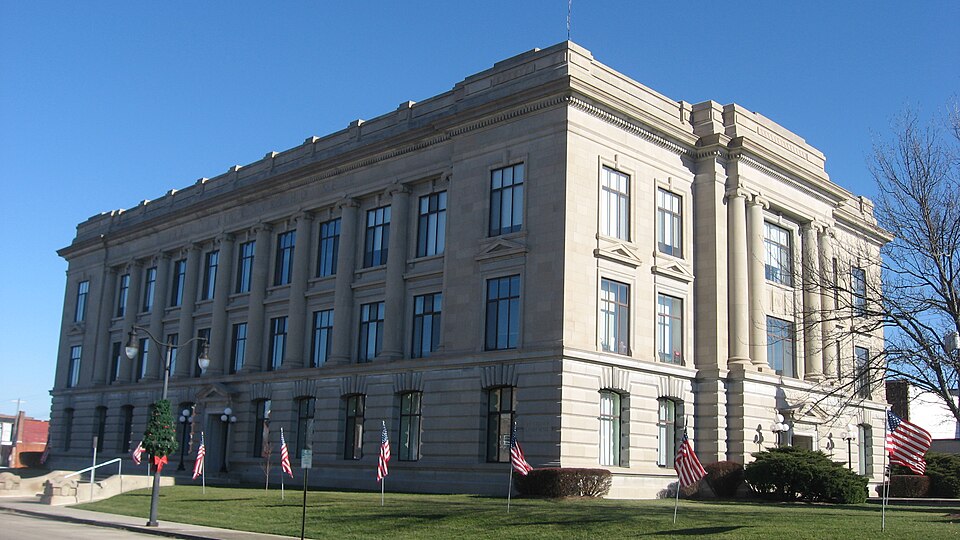
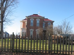
Listed on the National Register of Historic Places in 1981.
From the record
“Jay County Courthouse is a historic courthouse located at Portland, Indiana. It was built between 1915 and 1919, and is a three-story, Renaissance Revival style limestone building with a low roof behind a parapet.”
Wikipedia article Jay County Courthouse, CC BY-SA 4.0.
One of 8 National Register listings published here for Jay County · listed in 1981 · category: Building.
National Register reference number.81000016- the number the National Park Service assigned this property when it was listed, and the key its nomination file is catalogued under at the National Archives.
CHRISTOPHER COX - and Rebecca Headington began to share the joys and sorrows of life together on June 28, 1840, in Delaware county, Ohio. The comforts of home have been increased by the addition of Warner, born April 20, 1841 - he was a soldier of the late war, and died, August 6, 1862, at Oberly Hospital, Memphis, Tennessee. He was a member of Company B, 84th Regiment Indiana Volunteer Infantry ; Sherman was born September 3, 1842; Emeline, December 3, 1844; Ruth, August 11, 1846; Catherine, October 14, 1850 ; Lucina, September 21, 1854 ; Wesley, August 23, 1858 ; Geneva Kitura, December 10, 1859. A farmer of Wayne township, Mr. Cox receives mail at Portland. He was born'in Green county, Pennsylvania, November 5, 1813. His wife was born in Frederick county, Maryland, October 3, 1821.
JACOB M. H AY NE S - son of Henry and Achsah (March) Haynes, may be addressed at Portland, is engaged as an attoraey-at-faw, settled in Jay county in the year 1844, and was born at Monson, Hamden county, Massachusetts, April 12, 1817. His children are: Eleanor J., horn June 23, 1850; Susan J., November 3, 1851; Walter M., September 15, 1853; Sumner W., August 14, 1855; Elwood, October 14, 1857; Frank, March 28, 1861; Calvin, February 7, 1864; Edward, August 12, 1867. Mrs. Haynes was Hilinda S., daughter of William and Elizabeth (Morrow) Haines. Her wedding-day was August 27, 1846, the place, Portland, Indiana. Her natal day was April 5, 1828, the place, Clarksville, Clinton county, Ohio. Mr". Haynes filled the office of judge of common pleas from the year 1856 to that of 1871, and was circuit judge from 1871 to that of 1877.
Regional context, not property-specific
evidence. The federal mineral resources record lists
1 working within 5 miles of Jay County Courthouse: 1 producer.
All of them still produce. What was taken out: Stone, Crushed/Broken. Distance is straight-line from the
map coordinates, so a quarry counted here may appear on a neighbouring
settlement's page as well.
Regional context, not property-specific
evidence. The National Weather Service names
Portland, the town this property stands in, in 33 storm reports between 1998 and 2025: 23 thunderstorm wind, 6 hail, 3 flash flood, 1 lightning.
No death or injury is recorded in these reports. Each account below is quoted exactly as the forecast office
filed it, from the NOAA Storm Events Database, and each date
opens the federal record of that event.
SEVERAL ROADS ACROSS THE COUNTY SUSTAINED DAMAGE DUE TO PARTIAL OR COMPLETE WASHOUTS. MANY HOMES IN LOW LYING AREAS HAD THEIR BASEMENTS FLOODED ESPECIALLY SOUTH OF BRYANT.
Lightning struck a house in the 5300 block of E 100 S in Portland. Heavy damage was reported to the upstairs. A County deputy was able to awake the residents and get them to safety. Damage is estimated at $50,000.
Emergency management officials reported trees, power lines and phone lines down across the county. Some buildings had roofing blown off and others were impacted by trees.
Emergency management officials reported several trees were blown down onto camper trailers, with power lines laid out across trailers. Tents were blown over at the Jay county fair. No injuries were reported.
Emergency management officials reported some trees and tree limbs were blown down across portions of the county. Reports of leaning power poles were also received.
No historic map-sheet match is published
for this property yet. That does not mean no map exists. This record needs
a coordinate-quality review before it can be joined to a sheet boundary.
Browse the county's mapped places while that work is
pending.
Listed places nearby
4 within 8 miles
Other National Register properties close
enough to walk or drive between, ordered by distance from this one. Both
positions come from the same geocoding pass that matched these properties
to their map sheets.
Listing record. National Park Service National Register of Historic Places, listed-properties dataset, current to 2026-05-22.
Map join. Address geocoded through the United States Census geocoder, then tested against the published boundary of every sheet in the USGS Historical Topographic Map Collection.
How this page is made. Listing fields come from federal records; map-sheet coverage is a labelled coordinate-to-boundary calculation, not a source-field claim.
Mines and quarries. USGS Mineral Resources Data System (MRDS) https://mrdata.usgs.gov/mrds/ A work of the United States government, no copyright under 17 U.S.C. 105.
Storms. NOAA National Centers for Environmental Information, Storm Events Database https://www.ncei.noaa.gov/stormevents/ A work of the United States government, no copyright under 17 U.S.C. 105. Narratives are quoted verbatim from the National Weather Service report and are not edited or summarised.
 Block