BlockBefore
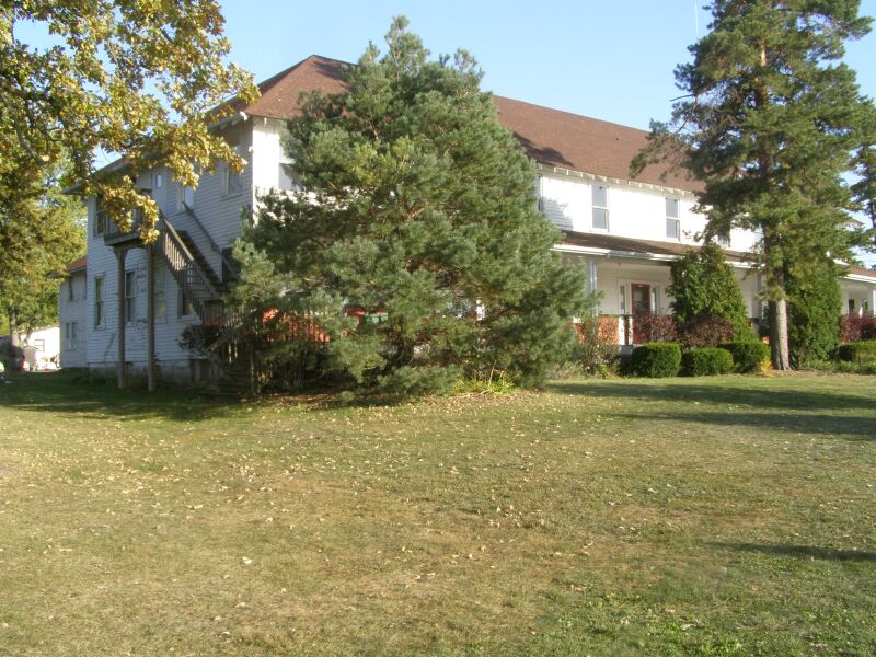
Photograph of Lassen Hotel
Photograph by Chris Light, CC BY-SA 3.0. Via Wikimedia Commons.

Lassen Hotel

Listed on the National Register of Historic Places in 1981.

From the record

“Lassen Hotel is a historic hotel building located at 7808 West 138th Place in Cedar Lake, Indiana. It is a two-story, T-shaped frame building sheathed in clapboard.”

Wikipedia article Lassen Hotel (Cedar Lake, Indiana), CC BY-SA 4.0.

One of 88 National Register listings published here for Lake County · listed in 1981 · category: Building.

Sources: the Wikipedia article · the case file at the National Archives · the National Register database, National Park Service · the Wikipedia article
The listing

  • What is counted as historic. The nomination lists 1 building as contributing to the listing.
  • Address. 7808 W. 138th Pl., Cedar Lake, 46303
  • When was it listed? July 1981
  • Category. building
  • Township. Center township
  • National Register reference number. 81000019 - the number the National Park Service assigned this property when it was listed, and the key its nomination file is catalogued under at the National Archives.

The ground it stands on

66 words

This property stands in Center Township. A Standard History of Lake County, Indiana, and the Calumet Region, published 1915 gives that township a chapter of its own.

The chapter covers varied and beautiful, first settlement, the avarriners, cedar lake's early fame, the taylors and their connections, calvin lilley and his hotel doctor lilley ivnd adonijah taylor.

Machine-read from a century-old scan, so expect the errors a machine makes: misspelled names, dropped words, stray characters.

Read the whole chapter on Center Township - 66 words on its settlement, mills, schools and churches.

Mines and quarries near this property

1 within 5 miles

Regional context, not property-specific evidence. The federal mineral resources record lists 1 working within 5 miles of Lassen Hotel: 1 producer. All of them still produce. What was taken out: Stone. Distance is straight-line from the map coordinates, so a quarry counted here may appear on a neighbouring settlement's page as well.

Where SiteCommodity StatusRecorded
Lake Co. Hwy. Dept.StoneProducer

Every working recorded in Lake County

Storms near this property

34 since 1993

Regional context, not property-specific evidence. The National Weather Service names Cedar Lake, the town this property stands in, in 34 storm reports between 1993 and 2025: 20 thunderstorm wind, 9 hail, 2 tornado, 1 lightning. The reports record 1 death and 1 injury. Each account below is quoted exactly as the forecast office filed it, from the NOAA Storm Events Database, and each date opens the federal record of that event.

WhenEvent Place namedHarm What the report says
July 2024Thunderstorm WindCedar Lake1 killedNumerous large tree limbs were blown down just west of Cedar Lake including a few that fell onto houses. One large tree limb, approximately 20 inches in diameter and 70 feet tall fell onto a one story house on 141st Court. The tree caused significant structural damage to the house and pinned a 44 year old woman in a bed. She died a short time later. Two other people in the house at the time were not injured.
May 1996LightningCedar Lake1 hurtno account filed
May 2007Thunderstorm WindCedar Lake$30,000A roof was partially torn off a building. Three utility poles were snapped near their base on Parish Avenue. Trees and power lines were also blown down.
May 2007Thunderstorm WindCedar Lake$10,000Tree limbs were blown down. A trailer was damaged near US 41. Four utility poles were blown down.
September 2014Thunderstorm WindCedar Lake$5,000Power poles were blown down.
June 1995Thunderstorm WindCedar Lake$1,000Trees were blown down.
March 2025Thunderstorm WindCedar Lake-The trunk of a large tree was snapped at the base.
March 2025Thunderstorm WindCedar Lake-Fascia was torn off of the canopy of a gas station on 133rd Ave in Cedar Lake.
May 2025Thunderstorm WindCedar Lake-A private weather station measured a wind gust to 66 mph.
March 2025Tornado (EF1)Cedar Lake-Damage surveys confirmed an EF-1 tornado in Cedar Lake. A brief tornado began near Wicker Avenue just south of 136th Place and moved rapidly northeast across Wicker Avenue and through a residential area of Cedar Lake. The tornado then continued north across West 133rd Avenue and along Lindberg Street before ending south of West 129th Avenue. Damage included several large uprooted or snapped trees, some of which fell onto and damaged homes. The most significant damage occurred east of Osborn Street between West 134th Place and West 133rd Lane, where a portion of a roof of a two story home landed in a neighboring yard, with peak winds estimated near 86 mph. In addition, a trampoline was found wrapped around a telephone pole along West 133rd Avenue.
March 2025Thunderstorm WindCedar Lake-Roofing and siding damage occurred around the neighborhood north of Hanover Central High School. A downed fence and tossed lawn furniture were also found.
March 2025Thunderstorm WindCedar Lake-Clay roofing tiles were ripped off of a church along 133rd Ave in Cedar Lake. A downed power line and a partially uprooted tree were also found in the area.
May 2024HailCedar Lake-Nickel to quarter size hail was reported near Lake Shore Drive and Cline Avenue.
July 2024Thunderstorm WindCedar Lake-A metal carport was bent and blown over. Tree limbs were blown down nearby.
July 2024Thunderstorm WindCedar Lake-Trees were uprooted just north of Cedar Lake. Tree limbs were blown down nearby.
March 2023Thunderstorm WindCedar Lake-A trained spotter estimated 60 mph winds as well as penny size hail.
June 2021Thunderstorm WindCedar Lake-Two trees were blown down onto houses.
December 2021Tornado (EF0)Cedar Lake-A tornado with peak winds of 85 mph touched down just south of 117th Avenue, west of Parrish Avenue where trees were uprooted. The tornado moved northeast and damaged a fence along Summerlin Street. The tornado crossed Cline Avenue producing minor tree damage and scattered light to moderate roof damage. A utility pole was snapped along Fathke Road, south of 109th Avenue. Tree damage continued north and south of 109th Avenue with the tornado crossing 109th Avenue near Hanley Street. The tornado continued producing minor tree damage as it crossed 105th Avenue. The tornado lifted near Maple Street, west of Main Street in Crown Point.
January 2020Heavy RainCedar Lake-Rainfall of 3.15 inches was reported.
August 2020Thunderstorm WindCedar Lake-A six inch diameter tree limb was blown down near 141st Avenue and Parrish Avenue in Cedar Lake.
June 2017Thunderstorm WindCedar Lake-Wind gusts were estimated between 50 and 60 mph.
June 2015Flash FloodCedar Lake-Roads were flooded in Cedar Lake and at least one pickup truck was half submerged on the flooded roads. An observer reported 3.94 inches of rainfall in Cedar Lake.
July 2012Thunderstorm WindCedar Lake-Two 10 inch diameter trees were blown down.
May 2007Thunderstorm WindCedar Lake-Tree limbs down in Brunswick.
August 2003Thunderstorm WindCedar Lake-Trees were blown down with estimated wind gusts to 70 mph.
October 2020HailCedar Lake-no account filed
May 2018HailCedar Lake-no account filed
May 2018Thunderstorm WindCedar Lake-no account filed
July 2017HailCedar Lake-no account filed
June 2012HailCedar Lake-no account filed
July 2012HailCedar Lake-no account filed
July 2003HailCedar Lake-no account filed
August 2003HailCedar Lake-no account filed
April 1993HailCedar Lake-no account filed

Every storm recorded in Lake County

Map coverage status

No historic map-sheet match is published for this property yet. That does not mean no map exists. This record needs a coordinate-quality review before it can be joined to a sheet boundary. Browse the county's mapped places while that work is pending.

Listed places nearby

6 within 8 miles

Other National Register properties close enough to walk or drive between, ordered by distance from this one. Both positions come from the same geocoding pass that matched these properties to their map sheets.

Photograph PropertyDistance Listed
Monon Park Dancing Pavillion0.8 miles2001
Albert Maack House4.1 miles2011
William Whitaker Landscape and House4.3 miles1999
Wellington A. Clark House4.5 miles2001
Crawford-Winslow House4.5 miles2013
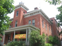
Lake County Sheriff's House and Jail4.5 miles1989

Sources for this property

National Archives recordThe nomination case file for reference 81000019 in Record Group 79.
Wikipedia articleCommunity-written account of this property, licensed CC BY-SA.
Lake CountyAll 88 listed properties in this county.

Provenance

  • Listing record. National Park Service National Register of Historic Places, listed-properties dataset, current to 2026-05-22.
  • Map join. Address geocoded through the United States Census geocoder, then tested against the published boundary of every sheet in the USGS Historical Topographic Map Collection.
  • How this page is made. Listing fields come from federal records; map-sheet coverage is a labelled coordinate-to-boundary calculation, not a source-field claim.
  • Mines and quarries. USGS Mineral Resources Data System (MRDS) https://mrdata.usgs.gov/mrds/ A work of the United States government, no copyright under 17 U.S.C. 105.
  • Storms. NOAA National Centers for Environmental Information, Storm Events Database https://www.ncei.noaa.gov/stormevents/ A work of the United States government, no copyright under 17 U.S.C. 105. Narratives are quoted verbatim from the National Weather Service report and are not edited or summarised.