
BlockBefore
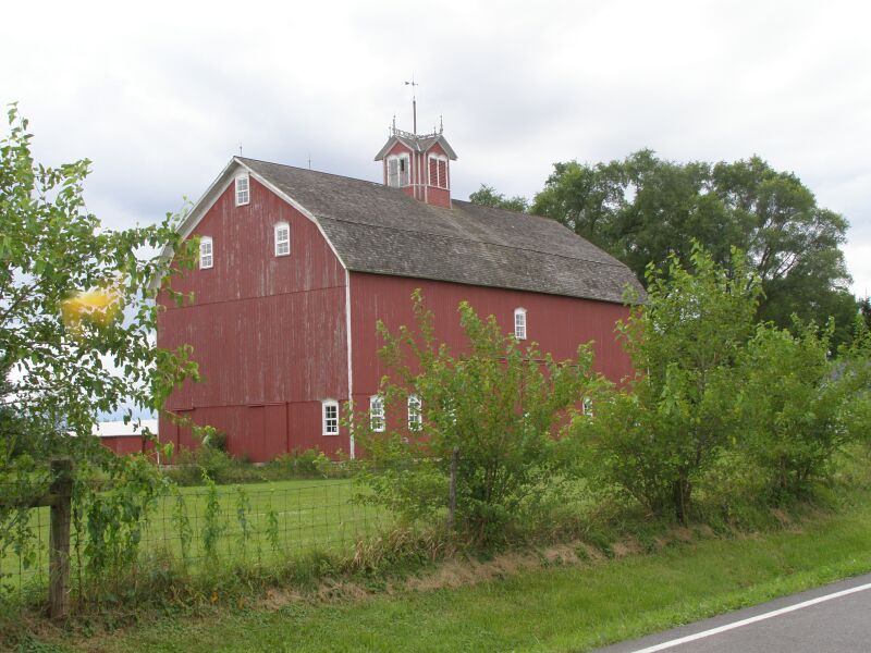
Photograph of Clinton D. Gilson Barn
Photograph by Chris Light at en.wikipedia, CC BY-SA 3.0. Via Wikimedia Commons.

Clinton D. Gilson Barn

Listed on the National Register of Historic Places in 1984.

From the record

“Gilson Farm is an outstanding example of a vernacular constructed farmstead for the late 19th century. The farm consists of outbuildings, the English barn, brooder houses, and a machine shop.”

Wikipedia article Clinton D. Gilson Barn, CC BY-SA 4.0.

One of 42 National Register listings published here for Porter County · listed in 1984 · category: Building.

Sources: the Wikipedia article · the case file at the National Archives · the National Register database, National Park Service
The listing

  • What is counted as historic. The nomination lists 1 building as contributing to the listing.
  • Listed as. Gilson, Clinton D., Barn - the National Register files a house under its owner's surname.
  • Address. 522 W. 650 S, Hebron, 46341
  • When was it listed? September 1984
  • Category. building
  • Township. Boone township
  • National Register reference number. 84001229 - the number the National Park Service assigned this property when it was listed, and the key its nomination file is catalogued under at the National Archives.

The ground it stands on

16,545 words

The chapter on Boone Township in Counties of Porter and Lake, Indiana : Historical and Biographical, published 1882 names Hebron. This is what it says, exactly as the scans read.

JOHN L. IJAKER was born in Kosciusko County, Ind., and is a son of Philip and Maria Baker, both of whom died in Kosciusko County. He received a common school education of the day, and at the age of seventeen learned the trade of a shoemaker, which he abandoned soon, but again returned to, and has since foUowsd as a life-business. la 1869, he came to Hebron, Porter County, Ind., where he now has a leading shop, most centrally located, and which does as large a business as aay other shop in the town. On the 1st of October, 1874, he was united in marriage to Miss Florence Thomas, a daughter of Eugene Thomas, a farmer. Mr. and Mrs. Baker have a family of two children, both living - Irvin E. and Maud F. Mr. Baker is a member of the order of Free and Accepted Masons. He is a good and worthy citizen.

Passage source: Counties of Porter and Lake, Indiana : Historical and Biographical, published 1882.

J. L. McALPIN is a native of Highland County, Ohio, where he lived until eighteen years of age, his father dying when he was one year old. The advantages being poor, he got but a scant education, being necessitated to work on bis mother's farm, and with whom he came to this State and located in Boone Township in 1844. In 1848, he was married to Miss Sarah Dinwiddie, daughter of Thomas Dinwiddie, farmer. By this union there were born nine children - Mary L., Augusta, Eliza J., Susie I., Emma (deceased), Maggie, John S. (deceased), James P. (deceased) and J. D. Mr. McAlpin commenced on sixty acres, then sold, and purchased his present farm of sixty acres, on which he has since lived. To this he has added until his farm now embraces ninety acres, with twenty acres of timber in the wet lands. This farm is one mile south of Hebron, and fine soil. In 1862, Mrs. McAlpin died, and he was married to his second wife, Miss Mary J. Morrow, by whom he has had seven children - Harry, William, Bernard, Carl, Freddie, Ina and Benjamin (deceased). Mr. and Mrs. McAlpin belong to the Methodist Episcopal Church.

Passage source: Counties of Porter and Lake, Indiana : Historical and Biographical, published 1882.

Machine-read from a century-old scan, so expect the errors a machine makes: misspelled names, dropped words, stray characters.

Read the whole chapter on Boone Township - 16,545 words on its settlement, mills, schools and churches.

Fires near this property

7 since 2003

Regional context, not property-specific evidence. The federal wildfire occurrence database lists 7 fires within 5 miles of Clinton D. Gilson Barn between 2003 and 2005, burning about 12 acres in total. None started naturally. None was recorded as arson. Distance is straight-line from the map coordinates, so a fire counted here may appear on a neighbouring settlement's page as well.

Reported cause Fires
Recreation and ceremony5
Missing data/not specified/undetermined1
Debris and open burning1

The most recent of them, most recent first, with the day each was reported and the service that recorded it.

DateCause SizeReported by Name on the report
2 August 2003Debris and open burningunder an acreIndiana State Fire Marshal's Officenot named
18 August 2003Recreation and ceremonyunder an acreIndiana State Fire Marshal's Officenot named
8 May 2005Recreation and ceremonyunder an acreIndiana State Fire Marshal's Officenot named
16 April 2005Recreation and ceremonyunder an acreIndiana State Fire Marshal's Officenot named
11 April 2005Recreation and ceremony8.0 acresIndiana State Fire Marshal's Officenot named
29 March 2005Missing data/not specified/undetermined3.0 acresIndiana State Fire Marshal's Officenot named
23 March 2004Recreation and ceremonyunder an acreIndiana State Fire Marshal's Officenot named

Every fire recorded in Porter County

Storms near this property

30 since 1997

Regional context, not property-specific evidence. The National Weather Service names Hebron, the town this property stands in, in 30 storm reports between 1997 and 2025: 10 hail, 9 thunderstorm wind, 7 flash flood, 3 flood. No death or injury is recorded in these reports. Each account below is quoted exactly as the forecast office filed it, from the NOAA Storm Events Database, and each date opens the federal record of that event.

WhenEvent Place namedHarm What the report says
September 2008Flash FloodHebron$1,000,000Basement and street flooding was reported in Valparaiso. Water was waist high in some locations with some roads impassible. Street flooding was also reported in South Haven. Route 2 near the Lake County Line was flooded and closed.
February 2018FloodHebron$155,000Record flooding occurred along the Kankakee River. The river crested at 13.65 feet at Dunns Bridge on February 26th, which was the highest crest on record. Flood stage at Dunns Bridge is 10 feet and major stage is 13 feet. The river crested at 14.46 feet near Kouts on February 26th, which was the second highest crest on record. Flood stage near Kouts is 11 feet and major stage is 14 feet. The flooding damaged culverts and levees near the river.
June 2011Thunderstorm WindHebron$20,000Route 2 from Lake County into Porter County was impassable due to numerous trees and utility poles blown down. As many as 60 trees were either damaged or blown down in Hebron. Trees and structures were damaged along 900S.
June 2011Flash FloodHebron$15,000A car was submerged in flood waters along US 231. Street flooding as well as standing water was reported.
July 2017Thunderstorm WindHebron$1,000Tree limbs were blown onto power lines along with other power lines blown down, near State Road 2 and County Road 900 S.
August 2016Flash FloodHebron$1,000Water over 500W 1000S to the point where the road was closed. Time estimated per radar.
April 2025Thunderstorm WindHebron-A private weather station measured a wind gust to 64 mph.
July 2024Thunderstorm WindHebron-A large tree and numerous tree limbs were blown down.
July 2024Thunderstorm WindHebron-Several tree limbs were blown down onto a house.
May 2021Flash FloodHebron-Approximately 6 inches to one foot of flowing water was reported across Route 2 on the north side of Hebron.
March 2018FloodHebron-Flooding continued along the Kankakee River during early March with the river finally falling below moderate flood stage on March 11th.
June 2015Flash FloodHebron-Several Roads in Hebron were closed due to flooding and at least on rescue had to be performed for a vehicle trapped in the flood waters.
May 2012Flash FloodHebron-Several roads in Hebron were flooded and impassable. Both retention ponds in town were overflowing with water approaching buildings in Industrial Park. A trained spotter in Hebron measured 4.60 inches of rainfall in 3 hours and 45 minutes.
August 2008FloodHebron-One to two feet of standing water was reported on State Road 8 with some flooding of homes and businesses.
February 2006HailHebron-Quarter size hail was reported near 700S and County Line Road near Hebron. The storm continued east northeast and quarter size hail was reported several minutes later near Route 30 and 100W, southwest of Valparaiso.
May 2004Thunderstorm WindHebron-Power lines and tree limbs were blown down.
May 2004Thunderstorm WindHebron-Large tree limbs were blown down.
March 2025Thunderstorm WindHebron-no account filed
September 2014Thunderstorm WindHebron-no account filed
July 2013HailHebron-no account filed
June 2012HailHebron-no account filed
May 2011HailHebron-no account filed
August 2007HailHebron-no account filed
June 2006HailHebron-no account filed
May 2004HailHebron-no account filed
July 2003HailHebron-no account filed
July 2003Flash FloodHebron-no account filed
May 2000Tornado (F0)Hebron-no account filed
May 1997HailHebron-no account filed

Every storm recorded in Porter County

Map coverage status

No historic map-sheet match is published for this property yet. That does not mean no map exists. This record needs a coordinate-quality review before it can be joined to a sheet boundary. Browse the county's mapped places while that work is pending.

Listed places nearby

1 within 8 miles

Other National Register properties close enough to walk or drive between, ordered by distance from this one. Both positions come from the same geocoding pass that matched these properties to their map sheets.

Photograph PropertyDistance Listed
Eli Sigler House2.3 miles2011

Sources for this property

National Archives recordThe nomination case file for reference 84001229 in Record Group 79.
Wikipedia articleCommunity-written account of this property, licensed CC BY-SA.
Porter CountyAll 42 listed properties in this county.

Provenance

  • Listing record. National Park Service National Register of Historic Places, listed-properties dataset, current to 2026-05-22.
  • Map join. Address geocoded through the United States Census geocoder, then tested against the published boundary of every sheet in the USGS Historical Topographic Map Collection.
  • How this page is made. Listing fields come from federal records; map-sheet coverage is a labelled coordinate-to-boundary calculation, not a source-field claim.
  • Wildfire. Short, Karen C. 2022. Spatial wildfire occurrence data for the United States, 1992-2020 [FPA_FOD_20221014]. 6th Edition. Fort Collins, CO: Forest Service Research Data Archive. https://doi.org/10.2737/RDS-2013-0009.6 Collected with United States Government funding and usable without additional permissions or fees.
  • Storms. NOAA National Centers for Environmental Information, Storm Events Database https://www.ncei.noaa.gov/stormevents/ A work of the United States government, no copyright under 17 U.S.C. 105. Narratives are quoted verbatim from the National Weather Service report and are not edited or summarised.