BlockBefore
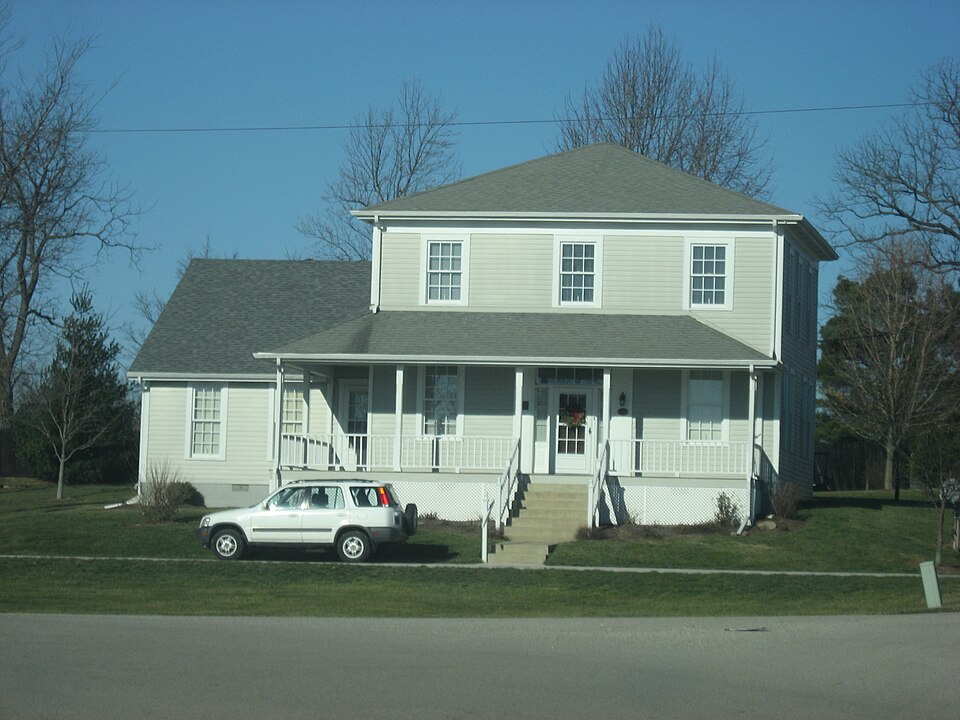
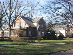
Photograph of Job Garner-Jacob W. Miller House
Photograph by Nyttend, Public domain. Via Wikimedia Commons.

Garner, Job-Miller, Jacob W., House

Listed on the National Register of Historic Places in 1986.

From the record

“Miller House is a historic home located at Harrison Township, Delaware County, Indiana. It was built about 1842, and is a two-story, square, Greek Revival style frame dwelling.”

Wikipedia article Job Garner-Jacob W. Miller House, CC BY-SA 4.0.

One of 47 National Register listings published here for Delaware County · listed in 1986 · category: Building.

Sources: the Wikipedia article · the case file at the National Archives · the National Register database, National Park Service
The listing

  • What is counted as historic. The nomination lists 1 building as contributing to the listing.
  • Listed as. Garner, Job--Miller, Jacob W., House - the National Register files a house under its owner's surname.
  • Address. Bethel Pike at CR 700 W, Bethel, 47342
  • When was it listed? June 1986
  • Category. building
  • Township. Harrison township
  • Architectural style. Greek Revival architecture
  • National Register reference number. 86001264 - the number the National Park Service assigned this property when it was listed, and the key its nomination file is catalogued under at the National Archives.

The ground it stands on

14,234 words

The chapter on Harrison Township in History of Delaware County, Indiana : with Illustrations and Biographical Sketches of Some of Its Prominent Men and Pioneers, published 1881 names Bethel. This is what it says, exactly as the scans read.

In the fall of 1842, Joshua Howell erected a mill on the banks of Big Kill Buck Creek, about a mile and a half below Bethel, in which he had a run of buhrs for grinding corn and supplying the neighborhood with meal. This was one of the primitive contrivances so often found in new settlements, and was only designed to subserve a baoe: (2 ary purpose.

Passage source: History of Delaware County, Indiana : with Illustrations and Biographical Sketches of Some of Its Prominent Men and Pioneers, published 1881.

In the year 1851, Jacob W. Miller completed a small brick storeroom adjoining his residence on the old Job Garner farm, and, in September of that year, went to Cincinnati, Ohio, and purchased a stock of merchandise, consisting of dry goods and groceries, which he hauled to his store in three wagons. He conducted a good trade here, renewing his stock from year to year until about 1855, when he sold the remnant of his stock to William Moore. During this time, he also served as Postmaster. Mr. Moore established himself at the village of Bethel, where he continued in trade about a year, and was succeeded by James K. Trimble, to whom Mr. Miller had the office of Postmaster transferred. Mr. Trimble sold his stock to Charles Kirk two or three years later, who continued to sell goods for several years longer. The office of Postmaster passed to Dr. Samuel E. Mitchell, the principal physician at that period, 3

Passage source: History of Delaware County, Indiana : with Illustrations and Biographical Sketches of Some of Its Prominent Men and Pioneers, published 1881.

Machine-read from a century-old scan, so expect the errors a machine makes: misspelled names, dropped words, stray characters.

Read the whole chapter on Harrison Township - 14,234 words on its settlement, mills, schools and churches.

Mines and quarries near this property

2 within 5 miles

Regional context, not property-specific evidence. The federal mineral resources record lists 2 workings within 5 miles of Garner, Job-Miller, Jacob W., House: 2 past producers. None of them still produces. What was taken out: Sand and Gravel, Construction, Limestone, Dimension. Distance is straight-line from the map coordinates, so a quarry counted here may appear on a neighbouring settlement's page as well.

Where SiteCommodity StatusRecorded
Buchanon Flagstones Co.LimestoneLimestone, DimensionPast Producer
Riddle Sand and Gravel PitSand and Gravel, ConstructionPast Producer

Every working recorded in Delaware County

Storms near this property

5 since 2001

Regional context, not property-specific evidence. The National Weather Service names Bethel, the town this property stands in, in 5 storm reports between 2001 and 2011: 5 thunderstorm wind. No death or injury is recorded in these reports. Each account below is quoted exactly as the forecast office filed it, from the NOAA Storm Events Database, and each date opens the federal record of that event.

WhenEvent Place namedHarm What the report says
June 2008Thunderstorm WindBethel$40,000Thunderstorm winds damaged the roof of Wes-Del High School and brought down tree limbs and utility lines in the immediate area. Other tree and utility line damage of a scattered nature was reported to the north from Gaston to Eaton and Shideler to Albany.
June 2008Thunderstorm WindBethel$10,000Thunderstorm winds blew a semi truck over on SR 69 at mile marker 46.
May 2011Thunderstorm WindBethel-A 70 mph thunderstorm wind gust was reported in this location.
June 2001Thunderstorm WindBethel-no account filed

Every storm recorded in Delaware County

Map coverage status

No historic map-sheet match is published for this property yet. That does not mean no map exists. This record needs a coordinate-quality review before it can be joined to a sheet boundary. Browse the county's mapped places while that work is pending.

Listed places nearby

6 within 8 miles

Other National Register properties close enough to walk or drive between, ordered by distance from this one. Both positions come from the same geocoding pass that matched these properties to their map sheets.

Photograph PropertyDistance Listed
Martin Hofherr Farm3.7 miles1992
Westwood Historic District6.5 miles1992
Forest Park Elementary School6.5 miles2023
Alva Kitselman House7.1 miles1994
Riverside Historic District7.2 miles1999
Hathaway-Parker House7.2 miles2022

Sources for this property

National Archives recordThe nomination case file for reference 86001264 in Record Group 79.
Wikipedia articleCommunity-written account of this property, licensed CC BY-SA.
Delaware CountyAll 47 listed properties in this county.

Provenance

  • Listing record. National Park Service National Register of Historic Places, listed-properties dataset, current to 2026-05-22.
  • Map join. Address geocoded through the United States Census geocoder, then tested against the published boundary of every sheet in the USGS Historical Topographic Map Collection.
  • How this page is made. Listing fields come from federal records; map-sheet coverage is a labelled coordinate-to-boundary calculation, not a source-field claim.
  • Mines and quarries. USGS Mineral Resources Data System (MRDS) https://mrdata.usgs.gov/mrds/ A work of the United States government, no copyright under 17 U.S.C. 105.
  • Storms. NOAA National Centers for Environmental Information, Storm Events Database https://www.ncei.noaa.gov/stormevents/ A work of the United States government, no copyright under 17 U.S.C. 105. Narratives are quoted verbatim from the National Weather Service report and are not edited or summarised.