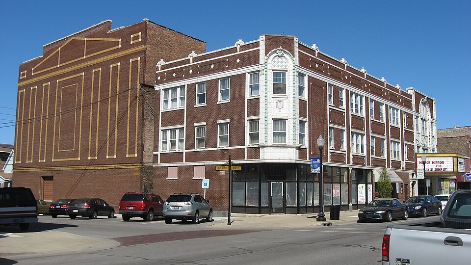
National Register reference number.87000069- the number the National Park Service assigned this property when it was listed, and the key its nomination file is catalogued under at the National Archives.
Mines and
quarries near this property
10 of 11 shown
Regional context, not property-specific
evidence. The federal mineral resources record lists
11 workings within 5 miles of Hoosier Theater Building: 4 producers, 4 plants, 2 unknowns, 1 past producer.
8 still produce. What was taken out: Sulfur, Limestone, General, Chromium, Stone, Crushed/Broken. Distance is straight-line from the
map coordinates, so a quarry counted here may appear on a neighbouring
settlement's page as well.
Regional context, not property-specific
evidence. The National Weather Service names
Whiting, the town this property stands in, in 19 storm reports between 1995 and 2025: 6 flood, 5 thunderstorm wind, 5 flash flood, 3 hail.
No death or injury is recorded in these reports. Each account below is quoted exactly as the forecast office
filed it, from the NOAA Storm Events Database, and each date
opens the federal record of that event.
Heavy rain fell across parts of far northwest Lake County causing significant flooding and flash flooding. In Hammond, numerous streets were flooded with cars stranded in the flood waters. At least 500 houses experienced some amount of flooding including basement flooding. The hardest hit area was roughly 3 square miles bounded by the Illinois/Indiana State line on the west, Detroit Street on the south, White Oak Avenue on the east and 137th Street on the north. Rainfall amounts included 4.79 inches in Hammond; 4.53 inches two miles west of East Chicago and 4.36 inches one mile north of Hammond.
Several instances of flash flooding took place around Gary, Hammond, Whiting, and East Chicago. A sewer storage facility exceeded capacity and overflowed. Multiple basements were flooded in Hammond. Up to three feet of water was reported on Indianapolis Blvd in Whiting from 120th to 129th Street. A portion of US-20 in East Chicago was closed due to flooding. Numerous reports of flooded basements, roads, and yards came out of the east side of Hammond and the west side of Gary. One private weather weather station in the area recorded 5.21 inches of rain while two others nearby recorded over three inches. An estimated 1,000 structures flooded around the area amounting to roughly $4 million in damages.
Golf ball- to ping-pong ball-size hail fell at Hammond. Half an inch to three-quarters inch hail and 54 mph winds occurred at Gary Airport. Tree limbs and power lines were downed throughout the northern part of the county.
Indiana DOT reported Route 41 (Calumet Avenue) was partially flooded at 129th Street due to a combination of rainfall and Lake Michigan extra-tropical storm surge.
Near Crown Point, Clark Street between 91st and 101st Streets was flooded and 121st Avenue near Iowa Street was flooded. In Hobart, Lakefront Park was flooded from Lake George. Near Highland, standing water was reported in one lane in each direction of Interstate 80/94. In Dyer, the intersection of 213 Street and Calumet Avenue was flooded. Near Winfield, 97th Avenue was flooded between Randolph and Clay Streets. North of Cedar Lake, 117th Avenue was flooded between Cline and Parrish Avenues. South of Lowell, Belshaw Road was flooded at Cedar Creek. In Schererville, multiple streets were flooded near Eagle Ridge Drive. North of Sumava Resorts, some lanes of Route 41 were closed due to flooding from the Kankakee River.
Many areas of Lake County were flooded with some roads flooded and closed. In Lake Station, a voluntary evacuation order was issued as the Deep River overflowed its banks and began to flood nearby homes. Storm total rainfall of 4.44 inches of rain was measured one mile north of Crown Point.
Heavy rain created street flooding in many areas across north central Lake County including Ruth Street at 77th Street in Schererville; 122nd Avenue in Crown Point and the intersection of 106th Avenue and Baker in Crown Point. Bell Road and 87th Avenue was also flooded in St. John. Storm total rainfall amounts included 3.52 inches three miles west southwest of Crown Point; 2.76 inches two miles east northeast of St. John; 2.04 inches one mile west southwest of Dyer and 1.91 inches about a mile and half east southeast of Merrillville.
A trained spotter was in Whiting Park along Lake Michigan when a severe line of thunderstorms moved through. Winds were estimated at 80 mph with a gustnado observed.
No historic map-sheet match is published
for this property yet. That does not mean no map exists. This record needs
a coordinate-quality review before it can be joined to a sheet boundary.
Browse the county's mapped places while that work is
pending.
Listed places nearby
6 within 8 miles
Other National Register properties close
enough to walk or drive between, ordered by distance from this one. Both
positions come from the same geocoding pass that matched these properties
to their map sheets.
Listing record. National Park Service National Register of Historic Places, listed-properties dataset, current to 2026-05-22.
Map join. Address geocoded through the United States Census geocoder, then tested against the published boundary of every sheet in the USGS Historical Topographic Map Collection.
How this page is made. Listing fields come from federal records; map-sheet coverage is a labelled coordinate-to-boundary calculation, not a source-field claim.
Mines and quarries. USGS Mineral Resources Data System (MRDS) https://mrdata.usgs.gov/mrds/ A work of the United States government, no copyright under 17 U.S.C. 105.
Storms. NOAA National Centers for Environmental Information, Storm Events Database https://www.ncei.noaa.gov/stormevents/ A work of the United States government, no copyright under 17 U.S.C. 105. Narratives are quoted verbatim from the National Weather Service report and are not edited or summarised.
 Block