
BlockBefore
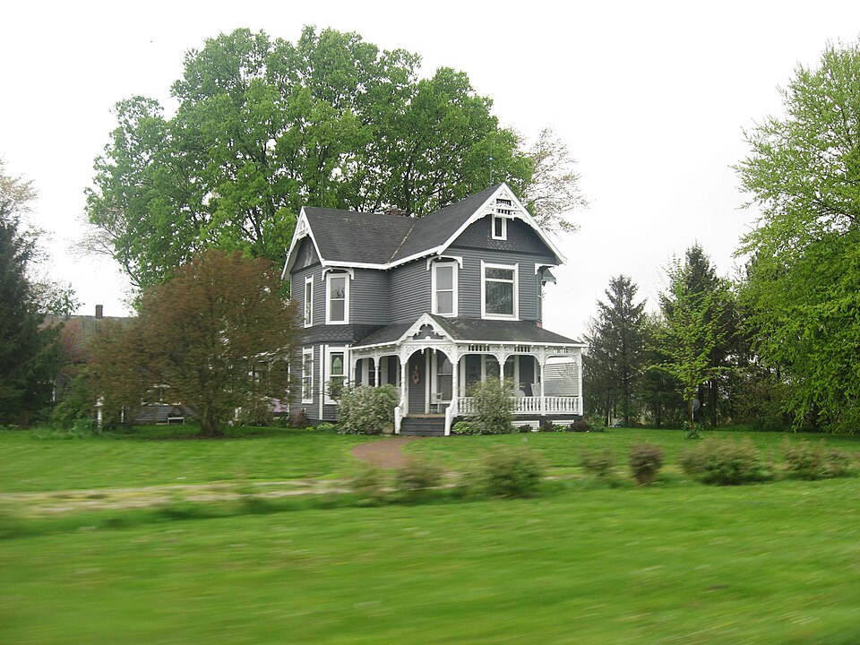
Photograph of Clinton F. Hesler Farm
Photograph by Nyttend, Public domain. Via Wikimedia Commons.

Clinton F. Hesler Farm

Listed on the National Register of Historic Places in 1989.

From the record

“Hesler Farm, also known as Clearview Farm, is a historic home and farm and national historic district located at Millcreek Township, Fountain County, Indiana. The farmhouse was built in 1896, and is a two-story, "T"-plan, Queen Anne style balloon frame dwelling.”

Wikipedia article Clinton F. Hesler Farm, CC BY-SA 4.0.

One of 19 National Register listings published here for Fountain County · listed in 1989 · category: District.

Sources: the Wikipedia article · the case file at the National Archives · the National Register database, National Park Service
The listing

  • What is counted as historic. The nomination lists 4 buildingss, 2 structuress as contributing to the listing.
  • Listed as. Hesler, Clinton F., Farm - the National Register files a house under its owner's surname.
  • Address. Co. Rd. 450 S. between 200 E. and 300 E., Veedersburg, 47987
  • When was it listed? July 1989
  • Category. district
  • Township. Millcreek township
  • National Register reference number. 89000770 - the number the National Park Service assigned this property when it was listed, and the key its nomination file is catalogued under at the National Archives.

The ground it stands on

13,616 words

This property stands in Millcreek Township. History of Fountain County : Together with Historic Notes on the Wabash Valley, Gleaned from Early Authors, Old Maps and Manuscripts, published 1881 gives that township a chapter of its own.

The chapter covers the township.

Machine-read from a century-old scan, so expect the errors a machine makes: misspelled names, dropped words, stray characters.

Read the whole chapter on Millcreek Township - 13,616 words on its settlement, mills, schools and churches.

Mines and quarries near this property

2 within 5 miles

Regional context, not property-specific evidence. The federal mineral resources record lists 2 workings within 5 miles of Clinton F. Hesler Farm: 2 unknowns. None of them still produces. What was taken out: Sand and Gravel, Construction. Distance is straight-line from the map coordinates, so a quarry counted here may appear on a neighbouring settlement's page as well.

Where SiteCommodity StatusRecorded
C. A. Miller Gravel PitSand and Gravel, ConstructionUnknown
F. I. Mitchell Gravel PitSand and Gravel, ConstructionUnknown

Every working recorded in Fountain County

Storms near this property

26 since 1996

Regional context, not property-specific evidence. The National Weather Service names Veedersburg, the town this property stands in, in 26 storm reports between 1996 and 2026: 14 thunderstorm wind, 8 hail, 2 tornado, 1 lightning. The reports record 1 death. Each account below is quoted exactly as the forecast office filed it, from the NOAA Storm Events Database, and each date opens the federal record of that event.

WhenEvent Place namedHarm What the report says
May 2004LightningVeedersburg1 killedA 24 year old male was hit by lightning on a baseball field and died shortly thereafter.
June 2023Thunderstorm WindVeedersburg$350,000Large tree downed by thunderstorm wind gusts on a house. Numerous other reports of downed trees across the county with over 2500 power outages.
August 2025Thunderstorm WindVeedersburg$30,000Thunderstorm winds downed power poles on West Public Service Road and blew metal roofing into fields on both sides of US Highway 136, one-eighth to one-quarter mile west of Interstate 74 overpass.
May 2019Thunderstorm WindVeedersburg$20,000Trees and utility lines were blown down due to damaging thunderstorm wind gusts. Scattered reports came in from around the county of this type of damage.
September 2011Thunderstorm WindVeedersburg$5,000Several trees, up to three feet in diameter, were downed due to damaging thunderstorm wind gusts.
August 2019Thunderstorm WindVeedersburg$1,000Multiple large tree limbs downed due to thunderstorm wind gusts.
April 2018Tornado (EF0)Veedersburg$1,000This EF-0 tornado, with a max wind speed of 75 mph, primarily went across cornfields while glancing two homesteads, where a few large tree branches were downed and one large trash dumpster blown over in a direction opposite from the environmental wind at the time.
June 2006Thunderstorm WindVeedersburg$1,000Trees and power lines downed.
October 1996Thunderstorm WindVeedersburg$500no account filed
August 2020Thunderstorm WindVeedersburg-A 67 mph thunderstorm wind gust was measured at this location.
August 2019Thunderstorm WindVeedersburg-This was a public report of an estimated 60 mph thunderstorm wind gust in this location.
June 2010Funnel CloudVeedersburg-Movement of the funnel cloud was to the southeast.
May 2006Thunderstorm WindVeedersburg-Trees were downed.
September 2005Thunderstorm WindVeedersburg-Trees were downed.
May 2004Tornado (F0)Veedersburg-State police reported a brief weak tornado touchdown in a field near Veedersburg.
March 2026HailVeedersburg-no account filed
May 2012HailVeedersburg-no account filed
March 2011HailVeedersburg-no account filed
June 2009HailVeedersburg-no account filed
September 2006HailVeedersburg-no account filed
July 2003Thunderstorm WindVeedersburg-no account filed
June 2002Thunderstorm WindVeedersburg-no account filed
May 2000Thunderstorm WindVeedersburg-no account filed
May 2000HailVeedersburg-no account filed
May 1998HailVeedersburg-no account filed
July 1996HailVeedersburg-no account filed

Every storm recorded in Fountain County

Map coverage status

No historic map-sheet match is published for this property yet. That does not mean no map exists. This record needs a coordinate-quality review before it can be joined to a sheet boundary. Browse the county's mapped places while that work is pending.

Listed places nearby

4 within 8 miles

Other National Register properties close enough to walk or drive between, ordered by distance from this one. Both positions come from the same geocoding pass that matched these properties to their map sheets.

Photograph PropertyDistance Listed
Veedersburg Clover Leaf Route Depot4.3 miles2020
Veedersburg First Christian Church4.5 miles2025
Cades Mill Covered Bridge5.1 miles2021
Wallace Covered Bridge6.5 miles2021

Sources for this property

National Archives recordThe nomination case file for reference 89000770 in Record Group 79.
Wikipedia articleCommunity-written account of this property, licensed CC BY-SA.
Fountain CountyAll 19 listed properties in this county.

Provenance

  • Listing record. National Park Service National Register of Historic Places, listed-properties dataset, current to 2026-05-22.
  • Map join. Address geocoded through the United States Census geocoder, then tested against the published boundary of every sheet in the USGS Historical Topographic Map Collection.
  • How this page is made. Listing fields come from federal records; map-sheet coverage is a labelled coordinate-to-boundary calculation, not a source-field claim.
  • Mines and quarries. USGS Mineral Resources Data System (MRDS) https://mrdata.usgs.gov/mrds/ A work of the United States government, no copyright under 17 U.S.C. 105.
  • Storms. NOAA National Centers for Environmental Information, Storm Events Database https://www.ncei.noaa.gov/stormevents/ A work of the United States government, no copyright under 17 U.S.C. 105. Narratives are quoted verbatim from the National Weather Service report and are not edited or summarised.