BlockBefore
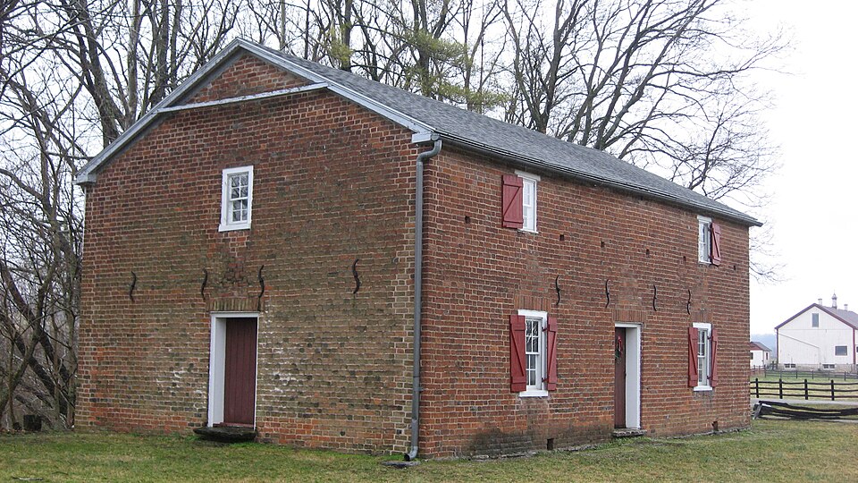
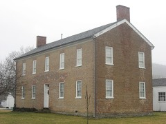
Photograph of Little Cedar Grove Baptist Church
Photograph by Nyttend, Public domain. Via Wikimedia Commons.

Little Cedar Grove Baptist Church

Listed on the National Register of Historic Places in 1990.

From the record

“Little Cedar Grove Baptist Church was organized in 1797 by some of the early Primitive Baptist settlers of Franklin County, Indiana. The historic church building, constructed in 1812, is the oldest church in the state of Indiana still standing on its original foundation.”

Wikipedia article Little Cedar Grove Baptist Church, CC BY-SA 4.0.

One of 13 National Register listings published here for Franklin County · listed in 1990 · category: Building.

Sources: the Wikipedia article · the case file at the National Archives · the National Register database, National Park Service
The listing

  • What is counted as historic. The nomination lists 1 building, 1 site as contributing to the listing.
  • Address. US 52 at Little Cedar Rd., Brookville, 47012
  • When was it listed? March 1990
  • Category. building
  • Township. Brookville township
  • National Register reference number. 90000366 - the number the National Park Service assigned this property when it was listed, and the key its nomination file is catalogued under at the National Archives.

What happened here

An account from the chapter on Brookville township. The inset identifies its exact source book and publication year.

From History of Franklin County, Indiana : Her People, Industries and Institutions, published 1915 - Brookville Township

Great Flood Of March 25, I913

The flood of March 25, 1913, was the greatest in volume of water, destruction of property and loss of life, of any that has ever visited this part of the White Water valley. Hundreds of thousands of dollars' worth of property was destroyed and fifteen lives lost. Six hundred people in Brookville were rendered homeless and scores of dwellings swept away and torn to pieces.

Read the rest of this passage

The ground it stands on

16,177 words

The chapter on Brookville Township in History of Franklin County, Indiana : Her People, Industries and Institutions, published 1915 names Brookville. This is what it says, exactly as the scans read.

The town of Brookville was platted August 8, 1808, by Thomas Manwarring and took its name from the middle name of one of the proprietors, Jesse Brooks Thomas, whose mother's maiden name was Brooks. At first it was called "Brooksville," but soon the "s" was dropped and ever since it has been Brookville. The plat was recorded January 8, 181 2. In 1820 Brookville was a military post and was garrisoned by a company of United States soldiers under command of Captain Grovenor of the regular army. In 1S23 the land office was established here with Lazarus Xoble as receiver. The office was first kept in a frame house on Court street and later in tlie building now occupied by Doctor Garrigues. The office was removed to Indianapolis in 1825.

Passage source: History of Franklin County, Indiana : Her People, Industries and Institutions, published 1915.

Of the first prime movers at Rrookville. it should be recorded in the annals of the place that Amos Butler, a native of Chester county. Pennsylvania, first entered land in Dearborn county in 1803. He had some means and after entering his land returned to Penn.sylvania. and upon his return found his lands overflowed with the waters of the Ohio river. He at once sought another location, and, coming to the present site of Brookville in the autumn of 180.] on foot, he decided to set his stakes here. As has been said, he remained here until 18 18. when he removed to Hanover, Indiana, where he died.

Passage source: History of Franklin County, Indiana : Her People, Industries and Institutions, published 1915.

Machine-read from a century-old scan, so expect the errors a machine makes: misspelled names, dropped words, stray characters.

Read the whole chapter on Brookville Township - 16,177 words on its settlement, mills, schools and churches.

Mines and quarries near this property

2 within 5 miles

Regional context, not property-specific evidence. The federal mineral resources record lists 2 workings within 5 miles of Little Cedar Grove Baptist Church: 2 producers. All of them still produce. What was taken out: Sand and Gravel, Construction. Distance is straight-line from the map coordinates, so a quarry counted here may appear on a neighbouring settlement's page as well.

Where SiteCommodity StatusRecorded
Franklin County Highway Dept.Sand and Gravel, ConstructionProducer
Harrison Sand & Gravel PitSand and Gravel, ConstructionProducer

Every working recorded in Franklin County

Storms near this property

60 since 1993

Regional context, not property-specific evidence. The National Weather Service names Brookville, the town this property stands in, in 60 storm reports between 1993 and 2026: 29 thunderstorm wind, 12 hail, 12 flood, 7 flash flood. No death or injury is recorded in these reports. Each account below is quoted exactly as the forecast office filed it, from the NOAA Storm Events Database, and each date opens the federal record of that event.

WhenEvent Place namedHarm What the report says
July 2021Flash FloodBrookville$100,000Water was flowing across a roadway and carrying debris. A few roads washout were also reported across central Franklin County.
July 2023Thunderstorm WindBrookville$10,000Numerous trees were downed across Franklin County.
July 2012Thunderstorm WindBrookville$10,000Several trees were downed, along with power lines due to damaging thunderstorm winds.
July 2002Thunderstorm WindBrookville$10,000Trees were blown down. A boat was capsized on Brookville Lake.
April 2024Thunderstorm WindBrookville$5,000Several trees were downed along U.S. Route 52.
August 2000Thunderstorm WindBrookville$5,000Trees and power lines downed.
July 1998Thunderstorm WindBrookville$5,000Trees downed.
June 1998Thunderstorm WindBrookville$5,000Numerous trees and power lines.
June 1995Thunderstorm WindBrookville$5,000Trees were downed, some on power lines.
July 2023Thunderstorm WindBrookville$4,000A few trees were downed in the Brookville area.
July 1996Thunderstorm WindBrookville$4,000no account filed
June 2022Thunderstorm WindBrookville$3,000A tree fell onto some wires along West Klein Street.
February 2006Thunderstorm WindBrookville$3,000Trees were downed.
June 2005Thunderstorm WindBrookville$3,000Trees were knocked down along US Route 52.
November 2005Thunderstorm WindBrookville$3,000Several trees were downed along Bath and Wolf Roads near Brookville.
June 2004Thunderstorm WindBrookville$3,000Trees were knocked down.
July 2003Thunderstorm WindBrookville$3,000Trees were downed near Brookville Lake and Cedar Grove.
July 2003Thunderstorm WindBrookville$3,000Trees were downed.
October 2001Thunderstorm WindBrookville$3,000A few trees were knocked down in town.
February 1999Thunderstorm WindBrookville$3,000Trees knocked down.
May 1999Thunderstorm WindBrookville$3,000Trees were blown down on St. Marys road.
July 1999Thunderstorm WindBrookville$3,000Numerous trees down.
April 1997Thunderstorm WindBrookville$3,000no account filed
April 2011Flash FloodBrookville$2,000Multiple roads were closed due to heavy rainfall.
August 2010Thunderstorm WindBrookville$2,000Trees and power poles were reported down due to damaging thunderstorm winds.
May 2004Thunderstorm WindBrookville$2,000One tree and several large limbs were downed.
July 2009Thunderstorm WindBrookville$1,000Large trees were reported down.
June 2000Flash FloodBrookville$1,000High water was over U.S. 52 on the east end of Brookville.
May 2019Thunderstorm WindBrookville$250A large branch was downed.
March 2026FloodBrookville-Levee Road was closed due to high water. Several additional roads were closed due to high water in the vicinity.
February 2026FloodBrookville-High water was reported across U.S. Route 52 and Landfill Road.
March 2023FloodBrookville-High water was reported across St. Marys Road.
February 2022FloodBrookville-High water was reported on St. Marys Road near Levee Road.
February 2022FloodBrookville-High water was reported on U.S. 52 just west of Franklin.
January 2019FloodBrookville-A road over Snail Creek was closed due to high water.
January 2019FloodBrookville-Levee Road near St Marys Road was closed due to high water.
January 2019FloodBrookville-High water closed Levee Road.
February 2019Flash FloodBrookville-Numerous roads were closed due to flooding.
February 2019FloodBrookville-High water was reported on Levee Rd along Snail Creek.
April 2019FloodBrookville-Law enforcement reported several creeks were flooded and some low water crossings were covered by water across the county.
May 2019FloodBrookville-High water was reported on several roads across the county.
November 2017Flash FloodBrookville-Several roads were closed in the Brookville area due to high water.
June 2016Thunderstorm WindBrookville-Wind speed was estimated by trained spotter.
July 2015FloodBrookville-High water was covering multiple roads in Brookville.
June 2014Thunderstorm WindBrookville-A few large limbs were downed in the area due to thunderstorm winds.
May 2006HailBrookville-Trees were also downed.
June 2003Flash FloodBrookville-High water was reported on Fox Run Road.
July 2001Flash FloodBrookville-Three to four feet of water reported on several roads
June 2025Thunderstorm WindBrookville-no account filed
July 2017HailBrookville-no account filed
April 2012HailBrookville-no account filed
April 2011HailBrookville-no account filed
May 2011HailBrookville-no account filed
April 2006HailBrookville-no account filed
May 2006HailBrookville-no account filed
April 1998HailBrookville-no account filed
March 1997HailBrookville-no account filed
May 1996HailBrookville-no account filed
April 1995HailBrookville-no account filed
April 1993HailBrookville-no account filed

Every storm recorded in Franklin County

Map coverage status

No historic map-sheet match is published for this property yet. That does not mean no map exists. This record needs a coordinate-quality review before it can be joined to a sheet boundary. Browse the county's mapped places while that work is pending.

Listed places nearby

5 within 8 miles

Other National Register properties close enough to walk or drive between, ordered by distance from this one. Both positions come from the same geocoding pass that matched these properties to their map sheets.

Photograph PropertyDistance Listed
Franklin County Seminary2.7 miles1974
Hermitage, The2.7 miles2004
Brookville Historic District2.9 miles1975
Cedar Grove Bridge3.2 miles2014
Salmon Turrell Farmstead7.7 miles2009

Sources for this property

National Archives recordThe nomination case file for reference 90000366 in Record Group 79.
Wikipedia articleCommunity-written account of this property, licensed CC BY-SA.
Franklin CountyAll 13 listed properties in this county.

Provenance

  • Listing record. National Park Service National Register of Historic Places, listed-properties dataset, current to 2026-05-22.
  • Map join. Address geocoded through the United States Census geocoder, then tested against the published boundary of every sheet in the USGS Historical Topographic Map Collection.
  • How this page is made. Listing fields come from federal records; map-sheet coverage is a labelled coordinate-to-boundary calculation, not a source-field claim.
  • Mines and quarries. USGS Mineral Resources Data System (MRDS) https://mrdata.usgs.gov/mrds/ A work of the United States government, no copyright under 17 U.S.C. 105.
  • Storms. NOAA National Centers for Environmental Information, Storm Events Database https://www.ncei.noaa.gov/stormevents/ A work of the United States government, no copyright under 17 U.S.C. 105. Narratives are quoted verbatim from the National Weather Service report and are not edited or summarised.