BlockBefore
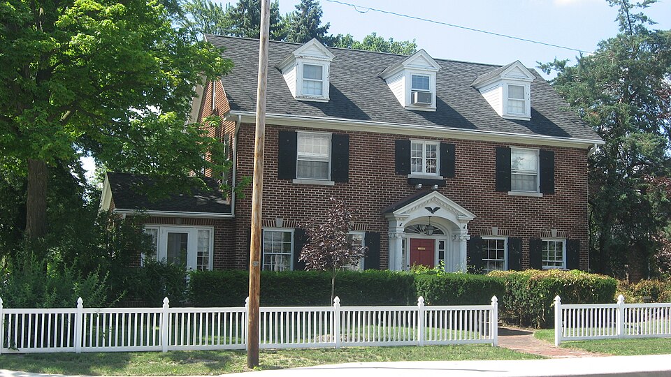
Photograph of Arthur Miller House
Photograph by Nyttend, Public domain. Via Wikimedia Commons.

Arthur Miller House

Listed on the National Register of Historic Places in 1992.

From the record

“Arthur Miller House, also known as the 253 East Market Guesthouse, is a historic home located at Nappanee, Indiana. It was built in 1922, and is a rectangular, three bay by two bay, Colonial Revival style brick dwelling.”

Wikipedia article Arthur Miller House, CC BY-SA 4.0.

One of 39 National Register listings published here for Elkhart County · listed in 1992 · category: Building.

Sources: the Wikipedia article · the case file at the National Archives · the National Register database, National Park Service
The listing

  • What is counted as historic. The nomination lists 1 building as contributing to the listing.
  • Listed as. Miller, Arthur, House - the National Register files a house under its owner's surname.
  • Address. 253 E. Market St., Nappanee, 46550
  • When was it listed? April 1992
  • Category. building
  • Township. Union township
  • Architectural style. Colonial Revival architecture
  • Architect. Clarence E. Frazier
  • National Register reference number. 92000184 - the number the National Park Service assigned this property when it was listed, and the key its nomination file is catalogued under at the National Archives.

The ground it stands on

28,158 words

The chapter on Union Township in History of Elkhart County, Indiana : Together with Sketches of Its Cities ... and Biographies of Representative Citizens : History of Indiana, Embracing Accounts of the Pre-historic Races .., published 1881 names Nappanee. This is what it says, exactly as the scans read.

The first ministers who preached through this section were the German Baptist, the Methodist, United Brethren, Mennonites and Regular Baptist. At present there are but three Church organizations in the township outside of the village of Nappanee. The first church was built by the Keformed a little east of Union Center, and was called "The Temple." The members have all left or died, and the building is long since gone. Tlie Regular Baptists were the next to erect a building. They have a very good house, on section 17. They have a good society here at present. The Mennonites have one church in the township, on section 19. Mr. Wisler is the pastor.

Passage source: History of Elkhart County, Indiana : Together with Sketches of Its Cities ... and Biographies of Representative Citizens : History of Indiana, Embracing Accounts of the Pre-historic Races .., published 1881.

Henry Gulp was born in Mahoning county, 0., Oct. 8, 1846. His father, Henry Culp, was born in Columbiana county, O., June 23,1820, and was married July 1, 1841, to Sarah Wanseller, who was born April 26, 1822, in Mahoning county. They had a family of 10 children, Liddie, Samuel (dec), George, Henry, Jacob (dec), John, Eli, Elizabeth, Sarah and Malinda. They left Ohio in 1857, coming to this tp. He had bought his land in November, 1851, buying 240 acres, and paying $750 for the lot. Previous to his moving here he had made several visits to this county, and had made some improvements on his land. He died on that farm- a few years ago. Had been a member of the Mennonite Church for a number of years. Henry, the subject of this sketch, is now living on the old homestead. He was married to Catharine Webber Aug. 7, 1873, who was born in Tuscarawas county, 0., Nov. 29, 1853, the daughter of Jacob and Catharine Webber, of Locke tp., and natives of Germany. Mr. and Mrs. Gulp's children are: Irene Bell, born June 5, 1874; Charles W., Oct. 12, 1875; Henry A., .July 19,1878; Eufns E., May 27, 1880. July 13,1880, Henry A. had three fingers on his right hand cut off with a rope and pulley while unloading haj^ in the barn. Mr. Culp has a good education, and for a number of years has followed teaching. At present he is farming. P. O., Nappanee.

Passage source: History of Elkhart County, Indiana : Together with Sketches of Its Cities ... and Biographies of Representative Citizens : History of Indiana, Embracing Accounts of the Pre-historic Races .., published 1881.

Machine-read from a century-old scan, so expect the errors a machine makes: misspelled names, dropped words, stray characters.

Read the whole chapter on Union Township - 28,158 words on its settlement, mills, schools and churches.

Storms near this property

18 since 1994

Regional context, not property-specific evidence. The National Weather Service names Nappanee, the town this property stands in, in 18 storm reports between 1994 and 2024: 12 thunderstorm wind, 4 hail, 2 tornado. The reports record 1 injury. Each account below is quoted exactly as the forecast office filed it, from the NOAA Storm Events Database, and each date opens the federal record of that event.

WhenEvent Place namedHarm What the report says
November 1998Thunderstorm WindNappanee1 hurt, $5,000ONE MAN WHILE DRIVING ALONG U.S. HIGHWAY 6 WAS SLIGHTLY INJURED WHEN A LARGE TREE LIMB FELL ONTO HIS CAR. THE VEHICLE SUSTAINED EXTENSIVE DAMAGE.
October 2007Tornado (EF3)Nappanee$11,000,000The tornado continued northeast out of Kosciusko County into the southeast side of Nappanee where the most extensive damage occurred. The width of the tornado decreased to one quarter mile and intensified just south of US-6 and County Road 7 as wind speeds increased to around 165 mph, in the upper range of the EF3 rating. The tornado went through an area populated by homes, restaurants, convenience stores and 3 RV plants, all of which sustained varying degrees of damage. Local officials reported that 459 buildings were damaged. Of these, 352 were homes with 52 of those being destroyed or uninhabitable. 81 businesses were damaged and 26 destroyed. A few minor injuries were also reported, mainly from people trapped in some of the houses and a few businesses. The tornado continued into the Blackstone subdivision where numerous homes were damaged or destroyed. The tornado continued to west of New Paris near the intersection of County Roads 46 and 17 where it lifted. Numerous vehicles of all varieties sustained severe damage. Damage is estimated around $11 million.
July 2024Thunderstorm WindNappanee$25,000Large tree down onto a home in Nappanee.
September 2011Tornado (EF0)Nappanee$10,000A NWS survey of damage and eyewitness reports of a possible tornado was performed near Nappanee. Four different eyewitnesses reported a tornado touch down at a business on the south side of US 6 and quickly track north across US 6, ending near County Road 54. Minor shingle and soffit damage was observed to 2 businesses. Small branches were also broken in the area. Eyewitnesses reported that branches and leaves were being bent upwards into the circulation but remained generally intact. Wind speed are estimated in the 70 to 75 mph range.
June 2021Thunderstorm WindNappanee$5,000Several tree limbs were blown down that caused some damage to the side of a residence. Also tree damage at the McCormick Creek Golf Course.
June 1994Thunderstorm WindNappanee$5,000Power lines were downed.
July 2022Thunderstorm WindNappanee-Widespread wind damage across Nappanee.
August 2020Thunderstorm WindNappanee-The public reported several large trees were blown down in Nappanee.
July 2018Thunderstorm WindNappanee-Local media reported a barn suffered mainly roof damage.
March 2017Thunderstorm WindNappanee-The public estimated wind gusts to 60 mph.
July 2014HailNappanee-The public posted pictures of hail slightly larger than the size of quarters on the office Facebook page.
June 2012Thunderstorm WindNappanee-A trained spotter reported a large tree down across the road, with power lines down in the area.
June 2009Thunderstorm WindNappanee-Pictures submitted to a South Bend television station indicated several large tree limbs being blown down in Nappanee.
July 2005Thunderstorm WindNappanee-Trees and tree limbs were blown down in and around Nappanee.
August 2000Thunderstorm WindNappanee-Large trees down.
June 2006HailNappanee-no account filed
June 1997HailNappanee-no account filed
April 1996HailNappanee-no account filed

Every storm recorded in Elkhart County

Map coverage status

No historic map-sheet match is published for this property yet. That does not mean no map exists. This record needs a coordinate-quality review before it can be joined to a sheet boundary. Browse the county's mapped places while that work is pending.

Listed places nearby

6 within 8 miles

Other National Register properties close enough to walk or drive between, ordered by distance from this one. Both positions come from the same geocoding pass that matched these properties to their map sheets.

Photograph PropertyDistance Listed
Frank and Katharine Coppes Houseunder 500 feet1990
Downtown Nappanee Historic Districtunder 500 feet1990
Nappaness Eastside Historic District0.1 miles2003
Nappanee West Park and Pavilion0.4 miles1994
Richard and Susan Pletcher House0.6 miles2020
Stahly-Nissley-Kuhns Farm0.9 miles1990

Sources for this property

National Archives recordThe nomination case file for reference 92000184 in Record Group 79.
Wikipedia articleCommunity-written account of this property, licensed CC BY-SA.
Elkhart CountyAll 39 listed properties in this county.

Provenance

  • Listing record. National Park Service National Register of Historic Places, listed-properties dataset, current to 2026-05-22.
  • Map join. Address geocoded through the United States Census geocoder, then tested against the published boundary of every sheet in the USGS Historical Topographic Map Collection.
  • How this page is made. Listing fields come from federal records; map-sheet coverage is a labelled coordinate-to-boundary calculation, not a source-field claim.
  • Storms. NOAA National Centers for Environmental Information, Storm Events Database https://www.ncei.noaa.gov/stormevents/ A work of the United States government, no copyright under 17 U.S.C. 105. Narratives are quoted verbatim from the National Weather Service report and are not edited or summarised.