BlockBefore
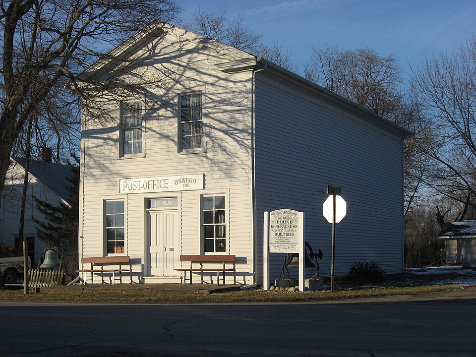
Photograph of John Pound Store
Photograph by Nyttend, Public domain. Via Wikimedia Commons.

John Pound Store

Listed on the National Register of Historic Places in 1992.

From the record

“John Pound Store is a historic commercial building located in Plain Township, Kosciusko County, Indiana. It was built in 1838, and is a two-story, rectangular Greek Revival style frame building with a front gable roof.”

Wikipedia article John Pound Store, CC BY-SA 4.0.

One of 17 National Register listings published here for Kosciusko County · listed in 1992 · category: Building.

Sources: the Wikipedia article · the case file at the National Archives · the National Register database, National Park Service


The listing

  • What is counted as historic. The nomination lists 1 building as contributing to the listing.
  • Listed as. Pound, John, Store - the National Register files a house under its owner's surname.
  • Address. Jct. of Armstrong Rd. and Second St., Oswego, 46582
  • When was it listed? June 1992
  • Category. building
  • Township. Plain township
  • Architectural style. Greek Revival architecture
  • National Register reference number. 92000672 - the number the National Park Service assigned this property when it was listed, and the key its nomination file is catalogued under at the National Archives.

Mines and quarries near this property

2 within 5 miles

Regional context, not property-specific evidence. The federal mineral resources record lists 2 workings within 5 miles of John Pound Store: 1 past producer, 1 producer. 1 still produces. What was taken out: Sand and Gravel, Construction. Distance is straight-line from the map coordinates, so a quarry counted here may appear on a neighbouring settlement's page as well.

Where SiteCommodity StatusRecorded
Fuller's Sand & Gravel PitSand and Gravel, ConstructionPast Producer
Leesburg Sand & GravelSand and Gravel, ConstructionProducer

Every working recorded in Kosciusko County

Storms near this property

37 since 1998

Regional context, not property-specific evidence. The National Weather Service names Oswego, the town this property stands in, in 37 storm reports between 1998 and 2025: 25 thunderstorm wind, 9 hail, 1 tornado, 1 flood. No death or injury is recorded in these reports. Each account below is quoted exactly as the forecast office filed it, from the NOAA Storm Events Database, and each date opens the federal record of that event.

WhenEvent Place namedHarm What the report says
July 2022Thunderstorm WindOswego$100,000Trees down on mobile homes around Chapman Lake. Reported via Facebook.
May 2025Thunderstorm WindOswego$40,000Large tree snapped at the base and fell onto N Kalorama Rd. A truck was crushed. A power pole was snapped.
July 2021LightningOswego$30,000Lightning strike caused structural fire that destroyed a garage and damaged a house.
May 2007Thunderstorm WindOswego$10,000A 12 inch diameter maple tree snapped off and fell onto a garage and power lines.
May 2007Thunderstorm WindOswego$10,000Two large trees at least 2 feet in diameter were snapped and hit the corner of a house.
March 1998Thunderstorm WindOswego$1,000trees blown down in town. shed destroyed.
July 2023HailOswego$1,000no account filed
July 2021Thunderstorm WindOswego-Wind gust estimated by off duty NWS employee.
July 2021Thunderstorm WindOswego-Numerous trees downed around Tippecanoe Lake.
July 2021Thunderstorm WindOswego-Numerous trees down.
May 2020HailOswego-Several quarter size hailstones noted by off duty NWS employee amongst mainly pea to penny size hail.
June 2020Thunderstorm WindOswego-Large branch split from a mostly healthy tree. Time estimated from radar.
June 2020Thunderstorm WindOswego-Large tree down on power lines on southeast side of Lake Tippecanoe. E County Road 650 N.
August 2020Thunderstorm WindOswego-An off duty NWS employee reported a large tree limb, over 2 feet in diameter, was blown down onto North County Road 300 East, south of East County Road 750 North. Rot was noted on the tree where it broke off.
May 2018HailOswego-Hail to the size of dimes was observed by an off duty NWS employee.
March 2017Thunderstorm WindOswego-An off duty NWS employee estimated wind gusts of 60 to 65 mph.
May 2015Thunderstorm WindOswego-Broadcast media reported a large gazebo was blown over and damaged.
June 2015Thunderstorm WindOswego-Several end segments of two center pivot irrigation systems were blown over and severely damaged.
June 2015Thunderstorm WindOswego-Multiple trees and powerlines down.
May 2015Thunderstorm WindOswego-A trained spotter estimated wind gusts to 65 mph with a wet microburst. Pea size hail was also observed.
July 2015FloodOswego-Reports of water on several roadways around Barbee Lake area. Some roads nearly impassable.
July 2014Thunderstorm WindOswego-An off duty NWS employee estimated wind gusts to 65 mph.
November 2013Tornado (EF1)Oswego-A survey of damage southwest of Oswego by a NWS Survey team revealed that a EF1 tornado produced damage along a roughly 1.7 mile path. Touchdown occurred in a harvested field southwest of the intersection of County Roads 450 North and 250 East. Several segments of a center pivot were flipped in this area. The tornado continued northeast crossing County Road 450 North, severely damaging 7 power poles, which were either snapped or bent at more than a 45 degree angle. One pole had 3 large transformers for the center pivot on it, with these being pushed on to the roadway. The tornado then impacted the Pines subdivision, northeast of 450 North and 250 East. Two to three dozen healthy pine trees between 30 and 50 feet tall were snapped or uprooted (DI: TS DOD: 4). One house was impacted on both sides with the roof being penetrated. Two vehicles had trees fall onto them, crushing them. The tornado moved through the remainder of the subdivision and adjacent properties with varying degrees of mainly roof and tree damage. The last noted damage involved a home on County Road 300 East, just south of Rader Road where moderate roof damage occurred and a narrow path of trees snapped in an adjacent wooded area. The tornado lifted shortly after this point prior to crossing Armstrong Road. Maximum wind speeds with the tornado are estimated at 95 mph.
November 2013Thunderstorm WindOswego-A off duty NWS employee reported a 12 inch diameter tree was twisted and split on the north side of Lake Tippecanoe. Other tree damage was found in the general area.
November 2013Thunderstorm WindOswego-Half of the east facing side of a older barn roof was blown off into an field to the north. A center pivot irrigation system in the same field has 2 segments flipped.
November 2013Thunderstorm WindOswego-Several pine trees and other varieties of trees were snapped just south of the Lake Tippecanoe Country Club.
September 2012HailOswego-An off duty NWS employee reported penny size hail fell for about a minute.
July 2011Thunderstorm WindOswego-An off duty NWS employee reproted a healthy 12 to 18 inch diameter tree down at the intersection of County Roads 400 East and 750 North.
June 2010Thunderstorm WindOswego-An off duty NWS employee reported trees and power lines down at the Lake Tippecanoe Country Club.
June 2010Thunderstorm WindOswego-An off duty NWS employee reported a two foot diameter maple tree was down across County Road 650 North. Power lines were also down in the area.
June 2010HailOswego-One inch hail with 55 to 60 mph wind gusts.
June 2008Thunderstorm WindOswego-A trained spotter reported a large tree being blown down blocking a cul-de-sac in Stanton Lakes Estates on the south side of Tippecanoe Lake.
August 2001Thunderstorm WindOswego-Trees blown down.
July 2015HailOswego-no account filed
June 2012HailOswego-no account filed
June 2008HailOswego-no account filed

Every storm recorded in Kosciusko County

Map coverage status

No historic map-sheet match is published for this property yet. That does not mean no map exists. This record needs a coordinate-quality review before it can be joined to a sheet boundary. Browse the county's mapped places while that work is pending.

Listed places nearby

6 within 8 miles

Other National Register properties close enough to walk or drive between, ordered by distance from this one. Both positions come from the same geocoding pass that matched these properties to their map sheets.

Photograph PropertyDistance Listed
Leesburg Historic District3.4 miles1993
Warner House-Warner Schoolhouse4.8 miles2023
DIXIE (sternwheeler)4.9 miles2009
Justin Zimmer House5.9 miles1991
Robert Orr Polygonal Barn6.0 miles1993
East Fort Wayne Street Historic District6.4 miles1993

Sources for this property

National Archives recordThe nomination case file for reference 92000672 in Record Group 79.
Wikipedia articleCommunity-written account of this property, licensed CC BY-SA.
Kosciusko CountyAll 17 listed properties in this county.

Provenance

  • Listing record. National Park Service National Register of Historic Places, listed-properties dataset, current to 2026-05-22.
  • Map join. Address geocoded through the United States Census geocoder, then tested against the published boundary of every sheet in the USGS Historical Topographic Map Collection.
  • How this page is made. Listing fields come from federal records; map-sheet coverage is a labelled coordinate-to-boundary calculation, not a source-field claim.
  • Mines and quarries. USGS Mineral Resources Data System (MRDS) https://mrdata.usgs.gov/mrds/ A work of the United States government, no copyright under 17 U.S.C. 105.
  • Storms. NOAA National Centers for Environmental Information, Storm Events Database https://www.ncei.noaa.gov/stormevents/ A work of the United States government, no copyright under 17 U.S.C. 105. Narratives are quoted verbatim from the National Weather Service report and are not edited or summarised.